

Saskatchewan Highway 5
Encyclopedia
This article focuses on the current designated Saskatchewan Highway 5, for Provincial Highway 5, Evergreen route portion, north west of Saskatoon see Saskatchewan Highway 16
.
Highway 5 is a major highway
in the Canadian
province of Saskatchewan
. It begins in downtown Saskatoon and runs eastward until the Manitoba
border, where it becomes Provincial Road 363. The highway is approximately 388 kilometres (241.1 mi) long. Between the early 1900s and 1970, Provincial Highway 5 extended approximately 630 kilometres (391.5 mi) in length. At this time it started in Lloydminster, Saskatchewan and traveled east to the Manitoba border. In the summer of 1970, the highway section between Lloydminster and Saskatoon was designated to be a portion of the northern Trans Canada Highway route, the Yellowhead
, shortening the highway length to 388 kilometres (241.1 mi).
Along the route are several heritage sites, an international bird watching area, saline lakes, as well as regional and provincial parks. Museums and historical markers commemorate the region's history along the highway.
and 12
), as 23rd Street East. Saskatoon is the most populous city located in central Saskatchewan
, Canada
, on the South Saskatchewan River
, with a metropolitan
population of 233,923. The highway starting terminus is the intersection of the Saskatoon Railway Station
a national historic site classified as a Designated Heritage Railway Station. The Fairbanks Morse Warehouse is a municipal heritage property along 23rd St. E. The highway turns north in downtown Saskatoon at the Saskatoon Transit
terminal which will soon be home to a $4.2 million transit terminal on 23rd Street between Second and Third Avenues. Along 25th Street, there is an historic marker commemorating the King Edward School building the first home of Saskatoon's city hall, and the Saskatoon World War memorial marker. The Meewasin Valley Trail
follows the South Saskatchewan River through Saskatoon which is visible when Highway 5 traverses the University Bridge
. At the top of the bridge is the University of Saskatchewan
's President's Residence which was constructed between 1910 and 1913.
East of the residence are the Memorial Gates
are a World War I memorial, the internment site of the Honourable Sir Frederick W. A. G. Haultain
's ashes,
the entrance to the Royal University Hospital
and University of Saskatchewan
. It becomes College Drive after crossing the river, and at km 4.4, the road diverges into a divided or twinned
highway with 2 lanes traveling in either direction across a meridian. Continuing east it intersects the Circle Drive city bypass route (Highway 16
) at an interchange that opened in 2006. After a signalized intersection with Central Avenue and an interchange with McKercher Drive, Highway 5 leaves Saskatoon's city limits at km 7, but the city is directly beside the highway until km 10, including a signalized intersection with the city's McOrmond Drive
.
According to the Atlas of Saskatchewan, the elevation around Saskatoon is between 500 to 600 m (1,640.4 to 1,968.5 ft). Leaving Saskatoon, travel is through a moist mixed grassland ecoregion
. Small Aspen groves surround sloughs which intersperse the glacial till landscape. The highway is paved between Saskatoon and Kamsack. Just outside the city limits, Highway 5 connects with Highway 41
at the site of a small commercial area that, as of 2007, included the Sundown Drive-In, one of Canada's last operational drive-in movie theatres. Highway 5 has been a divided highway through the College - Circle Dr. interchange remaining a divided highway until km 14.0. The remainder of the highway to the Manitoba border is an undivided highway. The communities of Strawberry Hills
, Discovery Ridge and Settler's Ridge are just off km 18 on Highway 5. At km 21, Highway 5 intersects Highway 316
.
Patience Lake
is located at km 24.3 and the Patience Lake potash mine is visible from Highway 5. "Patience Lake is a shallow, permanent, hypersaline lake east of Saskatoon in an area of extensive potash extraction. " The Patience Lake underground potash mine opened in 1975 was thereafter closed in 1987 due to extensive flooding. A new solution mine was reopened in 1988.
At km 41, it intersects Highway 671
, near the town of St. Denis
. At km 64, it intersects Highway 2
, where it begins a 6 kilometres (3.7 mi) concurrency
. Highway 5 continues east at km 70.
The town of Peterson is at km 76 and Highway 670
is at km 87. The ecoregion
changes to aspen parkland. Grasslands are resident on the upper slopes, and aspen groves on the lower areas. There tend to be more aspen groves in the aspen parkland as compared to the mixed grassland area. At km 109, the highway passes through the town of Dixon.
The city of Humboldt
is at km 115. Highway 5 also connects with Highway 20
in Humboldt. Humboldt is Saskatchewan
's newest city located 113 kilometres (70.2 mi) east of Saskatoon. Humboldt incorporated as a city in 2000. A new Humboldt tourist booth was opened in 1971 on the highway edge. Humboldt has many large murals depicting its German Catholic history located on building walls throughout the city. The Humboldt and District Museum and Gallery is located in a 1912 post office and customs office with its landmark tower clock which has been declared a national historic site.
The Carlton Trail Regional Economic Development Authority (REDA) coordinates and instigates economy in an area of rural municipalities (RM)
and towns in central Saskatchewan around Humboldt. The main industries of this area are agricultural, manufacturing, processing concerns as well as potash mining. A more recent industry to the area is tourism.
Situated 4 miles (6.4 km) west of Humboldt along Saskatchewan Highway 5 and two miles (3 km) south is the Kloppenburg Wildlife Refuge. North of the city is the Humboldt 18 hole grass green golf course on Highway 5. Original works by the painter, Count Berthold Von Imhoff, can be seen at churches located in Muenster and Humboldt.
The establishment of St. Peter’s Colony and Abbacy, Muenster, Saskatchewan has been designated as a Canadian National Historic Event on June 8, 2007, by the Minister of the Environment.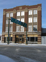 After Humboldt, Highway 5 passes through the town of Muenster
at km 123 and intersects with Highway 368
at km 125.
Highway 667
is at km 135, and the town of St. Gregor
is at km 136. It then passes through the town of Englefeld
(km 147). The village of Englefeld has a 600 pounds (272.2 kg) hog which was built to celebrate the 25th Annual Hogfest celebration.
The historic Wood Mountain - Fort Qu'Appelle Trail is marked with a point of interest marker. McNab Regional Park is located south of Watson
featuring pool and golf course. Watson is located at the concurrency of Highway 5 and Highway 6
, the CanAm Highway
. At the intersection with Highway 6
is Watson
(km 156). Watson (Vossen, NWT
) is known as the Industrial Crossroads of Saskatchewan being the midpoint between Regina, Saskatchewan
, and Saskatoon. Watson celebrated its first Santa Claus Day in 1922, and has erected a 25 feet (7.6 m)-high Santa Claus to commemorate this event.
.jpg) Highway 5 then passes through Wimmer (km 165), and Quill Lake
Highway 5 then passes through Wimmer (km 165), and Quill Lake
(km 175). The village of Quill Lake features a large statue of a Canada Goose located at the intersection of Highway 5 and Main Street.
The Highway 5 - Highway 35
junction features a historical plaque which commemorates the Touchwood Hills Hudson's Bay Company fur trade post established in 1879. The Carlton Trail and telegraph line are also remembered at this site where only a portion of the trail and the post cellar depression remain.
The highway continues east meeting with Highway 640
(km 176), Clair (km 191), and Paswegin
(km 199). It enters the town of Wadena
and intersects with Highway 35
at km 210. Wadena Wildlife Wetlands and Wadena Museum and Nature Centre are features of Wadena, the Northern Gateway to the Quill Lakes International Bird Area.
Wadena Wildlife Wetlands and Wadena Museum and Nature Centre are features of Wadena, the Northern Gateway to the Quill Lakes International Bird Area. These communities along with Quill Lake, “Goose Capital of Saskatchewan”, are all part of the Quill Lakes communities of Quill Lake.
Highway 5's next minor intersections are at Kylemore
and Highway 665
(km 222), Kuroki
and Highway 38
(km 232), Highway 310
(km 234), Margo
(km 244), Highway 617
and Invermay (km 256). Good Spirit REDA extends from Carlton Trail REDA to the Manitoba border, with its focus being tourism. The REDA is an agriculture based area around Good Spirit Provincial Park. Highway 755
connects with Rama (km 268) and Theodore. Theodore features the Theodore Heritage Museum and Whitesand regional park. The highway continues on through Dernic (km 278), Highway 47
and Buchanan
(km 286). Good Spirit Lake Provincial Park is located south of Buchanan and south west of Canora. Camping facilities provide access to beaches, lake and sand dunes. Highway 5 continues through the small hamlet of Tiny and intersects with Highway 664
(km 299). To the north of Highway 664is the Sturgis ski hill, as well as small heritage museums in both Sturgis and Preeceville. The junction with Highway 651
is at km 309. The town of Canora
, “Heart of Good Spirit Country” , is at km 311, where Highway 5 has a 2 km concurrency with Highway 9
, the Saskota flyway. "Lesia", a 25 feet (7.6 m) statue of a traditionally dressed Ukrainian woman offering bread and salt to travelers at Canora. Also within Canora are the Canora Station House Museum, Ukrainian Heritage Museum and Canada's Only Toy and Autograph Museum.
Ukrainian Orthodox Heritage Church of the Holy Trinity in Canora was designated a heritage site in 1984 by the town of Canora and it underwent restoration.
In the Good Spirit REDA, Canora features a flax straw processing plant, manufacturing plant, and meat processing plant.
The next few intersections on Highway 5 are at Highway 650
and Ross Junction (km 319), Mikado
(km 326), and Veregin
and Highway 637
(km 339). The town of Kamsack, at km 352, is the last major town that Highway 5 passes through. Within Kamsack is the Kamsack Power House Museum which features local artifacts and historic memorabilia.
The National Doukhobour Heritage Village is a historical attraction at Verigin.
Highway 5 also intersects Highway 8
near Kamsack. The highway is paved between Saskatoon and Kamsack, and gravel and unpaved through Togo and onwards to the Manitoba border.
To the north of Highway 5, and east of Kamsack is the Duck Mountain Provincial Park. This height of land location features Madge Lake, camping, fishing, and horse stables. The highest elevation is near the Manitoba border near Duck Mountain. Highway 5 travels south of Duck Mountain which has an elevation of between 700 to 800 m (2,296.6 to 2,624.7 ft). Highway 5 then intersects Highway 57
at km 360. From Highway 57, the highway turns south and meanders to the southeast as it passes the access to the town of Coté (km 365) and through the towns of Runnymede
(km 374) and Togo
(km 387), where it also intersects Highway 357
and Highway 369
. The Manitoba
border is at km 388, where Highway 5 becomes Provincial Road 363.
via Humboldt and Battleford, intersecting the future location of Highway 5 at Humboldt. The Dominion Government Telegraph Line was constructed in 1875, which was parallel to the future Highway 5. Both Red River Cart trail and telegraph line were abandoned in the 1920s.
In 1925, Provincial Highway 5, the Evergreen Route, followed the surveyed rail line route of the Canadian Northern Railway, later the Canadian National Railway
. Provincial Highway 5 had a western terminus at Lloydminster
located on the Alberta
- Saskatchewan
border. When the province was surveyed, the road evolved from a dirt road to a gravel road. This was finally improved to an all weather road known as Provincial Highway 5 from the Alberta
–Saskatchewan border bypassing Saskatoon to the north, and continuing on to the Manitoba
–Saskatchewan border. Just as the rail line went through Aberdeen, Warman, and Langham, so too did Provincial Highway 5. In 1925, access from Saskatoon to Provincial Highway 5 was via Provincial Highway 12 which was a route due north of the city. The other connection was Provincial Highway 27 which traveled east and north from Saskatoon connecting to Provincial Highway 5 at the junction located at the town of Aberdeen. In the late 1950s and 1960s, the highway was straightened and widened. During this process, the current Saskatchewan Highway 5 connected Humboldt and Saskatoon in a more direct west and east highway. The old place names of Warman, Aberdeen, Vonda, Prudhomme, Dana, Bruno, and Carmel located on Provincial Highway 5 were no longer place names along Saskatchewan Highway 5. Now the Highway 17 concurrency
was the only north-south stretch between Humboldt and Saskatoon and Meacham
the only place name. On August 15, 1970 the Yellowhead was opened for the northern Trans-Canada route and the north western half of Provincial Highway 5 between Saskatoon and Lloydminster was designated as Saskatchewan Highway 16
, the Yellowhead route.
Travel along the Provincial Highway 5 before the 1940s would have been traveling on the square following the township road allowances, barbed wire fencing and rail lines. As the surveyed township roads were the easiest to travel, the first highway
was designed on 90-degree, right-angle corners as the distance traversed the prairie along range roads and township roads. 1926 Saskatchewan map
Highway 5 was constructed through Englefeld in 1961. John Koenig was one of the first residents of Englefeld to own a car, a Ford touring car purchased in the 1920s.
crossing lights were installed on Highway 5 at the east end of Humboldt. At the junction of Highway 20
and Highway 5, there were traffic lights installed in 1973. West Humboldt properties announced in the fall of 2008 that The Quill Centre will be opened in the fall of 2009 along Highway 5.
Jan 3, 1910, was the first meeting of the RM of Blucher 343. In 1911, early homesteaders could choose to pay taxes at $9.00 per quarter section of land or working off $4.00 of this expense by constructing roads. A labourer and two horse team could earn 50 cents an hour and a four horse team with a driver was allotted 70 cents an hour.
A resurfacing improvement project was undertaken for an 11.7 kilometres (7.3 mi) stretch between Mikado and Canora. The $1 million dollar project was completed the summer of 2001. In the summer of 2000, 13.1 kilometres (8.1 mi) received resurfacing improvements between Verigin and Mikado. In February 2003, the Department of Highways
awarded a tender to resurface 8 kilometres (5 mi) from Quill Lake and eastward. "We are maintaining our focus on building better highways. Work on this $
940,000 resurfacing project ... should be complete within two weeks", said Highways and Transportation Minister Mark Wartman.
Saskatchewan Highway 16
Highway 16 is a provincial paved highway in the Canadian province of Saskatchewan. It is the Saskatchewan section of the Yellowhead Highway, and also the Trans-Canada Highway Yellowhead section. The main purpose of this highway is to connect Saskatchewan with Canadian cities such as Edmonton and...
.
Highway 5 is a major highway
Highway
A highway is any public road. In American English, the term is common and almost always designates major roads. In British English, the term designates any road open to the public. Any interconnected set of highways can be variously referred to as a "highway system", a "highway network", or a...
in the Canadian
Canada
Canada is a North American country consisting of ten provinces and three territories. Located in the northern part of the continent, it extends from the Atlantic Ocean in the east to the Pacific Ocean in the west, and northward into the Arctic Ocean...
province of Saskatchewan
Saskatchewan
Saskatchewan is a prairie province in Canada, which has an area of . Saskatchewan is bordered on the west by Alberta, on the north by the Northwest Territories, on the east by Manitoba, and on the south by the U.S. states of Montana and North Dakota....
. It begins in downtown Saskatoon and runs eastward until the Manitoba
Manitoba
Manitoba is a Canadian prairie province with an area of . The province has over 110,000 lakes and has a largely continental climate because of its flat topography. Agriculture, mostly concentrated in the fertile southern and western parts of the province, is vital to the province's economy; other...
border, where it becomes Provincial Road 363. The highway is approximately 388 kilometres (241.1 mi) long. Between the early 1900s and 1970, Provincial Highway 5 extended approximately 630 kilometres (391.5 mi) in length. At this time it started in Lloydminster, Saskatchewan and traveled east to the Manitoba border. In the summer of 1970, the highway section between Lloydminster and Saskatoon was designated to be a portion of the northern Trans Canada Highway route, the Yellowhead
Saskatchewan Highway 16
Highway 16 is a provincial paved highway in the Canadian province of Saskatchewan. It is the Saskatchewan section of the Yellowhead Highway, and also the Trans-Canada Highway Yellowhead section. The main purpose of this highway is to connect Saskatchewan with Canadian cities such as Edmonton and...
, shortening the highway length to 388 kilometres (241.1 mi).
Along the route are several heritage sites, an international bird watching area, saline lakes, as well as regional and provincial parks. Museums and historical markers commemorate the region's history along the highway.
Travel route
Highway 5 begins near downtown Saskatoon at Idylwyld Drive North (Highway 11Saskatchewan Highway 11
Highway 11 is a major north-south highway in Saskatchewan, Canada that connects the province's three largest cities: Regina, Saskatoon and Prince Albert. It is a structural pavement major arterial highway which is approximately long. It is also known as the Louis Riel Trail after the 19th century...
and 12
Saskatchewan Highway 12
Highway 12 is a major highway in the Canadian province of Saskatchewan. It begins in Saskatoon at the intersection of Idylwyld Drive and 22nd Street, initially running north on Idylwyld concurrently with Highway 11. Just outside Saskatoon's northern city limits, Highway 11 branches off and Highway...
), as 23rd Street East. Saskatoon is the most populous city located in central Saskatchewan
Saskatchewan
Saskatchewan is a prairie province in Canada, which has an area of . Saskatchewan is bordered on the west by Alberta, on the north by the Northwest Territories, on the east by Manitoba, and on the south by the U.S. states of Montana and North Dakota....
, Canada
Canada
Canada is a North American country consisting of ten provinces and three territories. Located in the northern part of the continent, it extends from the Atlantic Ocean in the east to the Pacific Ocean in the west, and northward into the Arctic Ocean...
, on the South Saskatchewan River
South Saskatchewan River
The South Saskatchewan River is a major river in Canada that flows through the provinces of Alberta and Saskatchewan....
, with a metropolitan
Metropolitan area
The term metropolitan area refers to a region consisting of a densely populated urban core and its less-populated surrounding territories, sharing industry, infrastructure, and housing. A metropolitan area usually encompasses multiple jurisdictions and municipalities: neighborhoods, townships,...
population of 233,923. The highway starting terminus is the intersection of the Saskatoon Railway Station
Saskatoon Railway Station (Canadian Pacific)
The Saskatoon Railway Station is a National Historic Site of Canada in Saskatoon, Saskatchewan, Canada which was officially declared on December 19, 1994 as having national historical significance. There is protected area status on this Château style station site. Saskatoon earned the nickname...
a national historic site classified as a Designated Heritage Railway Station. The Fairbanks Morse Warehouse is a municipal heritage property along 23rd St. E. The highway turns north in downtown Saskatoon at the Saskatoon Transit
Saskatoon Transit
Saskatoon Transit is the public transport arm of the City of Saskatoon, Saskatchewan, Canada. It operates a fleet of diesel buses. A total of 23 bus routes serve every area of the city, carrying approximately 11 million passengers in 2008...
terminal which will soon be home to a $4.2 million transit terminal on 23rd Street between Second and Third Avenues. Along 25th Street, there is an historic marker commemorating the King Edward School building the first home of Saskatoon's city hall, and the Saskatoon World War memorial marker. The Meewasin Valley Trail
Meewasin Valley Authority
The Meewasin Valley Authority is a conservation organization created by the Provincial Government of Saskatchewan in Canada and is dedicated to conserving the cultural and natural resources of the South Saskatchewan River Valley. The authorities activities include education, development and...
follows the South Saskatchewan River through Saskatoon which is visible when Highway 5 traverses the University Bridge
University Bridge (Saskatoon)
University Bridge spans the South Saskatchewan River between Clarence Avenue and College Drive on the east shore with 25th Street on the west in Saskatoon, Saskatchewan Canada. The bridge is also known as the 25th Street Bridge and is a major commuter route between the two halves of Saskatoon...
. At the top of the bridge is the University of Saskatchewan
University of Saskatchewan
The University of Saskatchewan is a Canadian public research university, founded in 1907, and located on the east side of the South Saskatchewan River in Saskatoon, Saskatchewan, Canada. An "Act to establish and incorporate a University for the Province of Saskatchewan" was passed by the...
's President's Residence which was constructed between 1910 and 1913.
East of the residence are the Memorial Gates
Memorial Gates (University of Saskatchewan)
Memorial Gates are a military memorial which are part of the University of Saskatchewan, City of Saskatoon, Saskatchewan. These Gates were first planned as the entrance gates to the University Campus...
are a World War I memorial, the internment site of the Honourable Sir Frederick W. A. G. Haultain
Frederick W. A. G. Haultain
Sir Frederick William Alpin Gordon Haultain was a lawyer and a long serving Canadian politician and judge. His career in provincial and territorial legislatures stretched into four decades...
's ashes,
the entrance to the Royal University Hospital
Royal University Hospital
Royal University Hospital, often abbreviated RUH, is one of three hospitals in Saskatoon, Saskatchewan. It is located on the University of Saskatchewan campus. RUH is a teaching hospital and closely tied to the College of Medicine within the university. It was opened on May 14, 1955 by...
and University of Saskatchewan
University of Saskatchewan
The University of Saskatchewan is a Canadian public research university, founded in 1907, and located on the east side of the South Saskatchewan River in Saskatoon, Saskatchewan, Canada. An "Act to establish and incorporate a University for the Province of Saskatchewan" was passed by the...
. It becomes College Drive after crossing the river, and at km 4.4, the road diverges into a divided or twinned
Dual carriageway
A dual carriageway is a class of highway with two carriageways for traffic travelling in opposite directions separated by a central reservation...
highway with 2 lanes traveling in either direction across a meridian. Continuing east it intersects the Circle Drive city bypass route (Highway 16
Saskatchewan Highway 16
Highway 16 is a provincial paved highway in the Canadian province of Saskatchewan. It is the Saskatchewan section of the Yellowhead Highway, and also the Trans-Canada Highway Yellowhead section. The main purpose of this highway is to connect Saskatchewan with Canadian cities such as Edmonton and...
) at an interchange that opened in 2006. After a signalized intersection with Central Avenue and an interchange with McKercher Drive, Highway 5 leaves Saskatoon's city limits at km 7, but the city is directly beside the highway until km 10, including a signalized intersection with the city's McOrmond Drive
McOrmond Drive (Saskatoon, Saskatchewan)
McOrmond Drive is a road serving the city of Saskatoon, Saskatchewan. It begins as a grid road at 8th Street East outside of Saskatoon, and runs through the Corman Park Rural Municipality, before turning into a minor arterial road at a signalized intersection at Highway 5 . The road was originally...
.
According to the Atlas of Saskatchewan, the elevation around Saskatoon is between 500 to 600 m (1,640.4 to 1,968.5 ft). Leaving Saskatoon, travel is through a moist mixed grassland ecoregion
Ecoregion
An ecoregion , sometimes called a bioregion, is an ecologically and geographically defined area that is smaller than an ecozone and larger than an ecosystem. Ecoregions cover relatively large areas of land or water, and contain characteristic, geographically distinct assemblages of natural...
. Small Aspen groves surround sloughs which intersperse the glacial till landscape. The highway is paved between Saskatoon and Kamsack. Just outside the city limits, Highway 5 connects with Highway 41
Saskatchewan Highway 41
Highway 41 is a highway in the Canadian province of Saskatchewan. It runs from Highway 5 in Saskatoon to Highway 6/Highway 3 in Melfort. Highway 41 is about . long....
at the site of a small commercial area that, as of 2007, included the Sundown Drive-In, one of Canada's last operational drive-in movie theatres. Highway 5 has been a divided highway through the College - Circle Dr. interchange remaining a divided highway until km 14.0. The remainder of the highway to the Manitoba border is an undivided highway. The communities of Strawberry Hills
Strawberry Hills, Saskatchewan
Strawberry Hills is a residential subdivision located in the rural municipality of Aberdeen No. 373, Saskatchewan. It is named after the Strawberry Hills upon which it sits, the hills having been named as a result of an abundance of wild strawberries to be found in the region.Strawberry Hills is...
, Discovery Ridge and Settler's Ridge are just off km 18 on Highway 5. At km 21, Highway 5 intersects Highway 316
Saskatchewan Highway 316
Highway 316 is a highway in the Canadian province of Saskatchewan which runs 29 km in length. It runs from Highway 16 near Clavet to Highway 5. Highway 316 is about 17 km long. This area is an industrial commercial area along Highway #316 which extends from Clavet north to the PCS Patience Lake...
.
Patience Lake
Patience Lake
Patience Lake is a lake in central Saskatchewan, Canada east of Saskatoon. The lake is located in the rural municipality of Blucher No. 343. The lake serves as a groundwater discharge region for higher elevations to the east and west....
is located at km 24.3 and the Patience Lake potash mine is visible from Highway 5. "Patience Lake is a shallow, permanent, hypersaline lake east of Saskatoon in an area of extensive potash extraction. " The Patience Lake underground potash mine opened in 1975 was thereafter closed in 1987 due to extensive flooding. A new solution mine was reopened in 1988.
At km 41, it intersects Highway 671
Saskatchewan Highway 671
Highway 671 is a highway in the Canadian province of Saskatchewan. It runs from Highway 5 near St. Denis to Highway 41. Highway 671 is about 30 km long....
, near the town of St. Denis
St. Denis, Saskatchewan
St. Denis is a community in Saskatchewan....
. At km 64, it intersects Highway 2
Saskatchewan Highway 2
Highway 2 is a provincial highway in the Canadian province of Saskatchewan. It is the longest Saskatchewan Highway, at 809 km . The highway is partially divided and undivided. However, only about near Moose Jaw, near Chamberlain, and near Prince Albert are divided highway...
, where it begins a 6 kilometres (3.7 mi) concurrency
Concurrency (road)
A concurrency, overlap, or coincidence in a road network is an instance of one physical road bearing two or more different highway, motorway, or other route numbers...
. Highway 5 continues east at km 70.
The town of Peterson is at km 76 and Highway 670
Saskatchewan Highway 670
Highway 670 is a highway in the Canadian province of Saskatchewan. It runs from Highway 2 near Young to Highway 16 near Viscount. Highway 670 is about 28 km long....
is at km 87. The ecoregion
Ecoregion
An ecoregion , sometimes called a bioregion, is an ecologically and geographically defined area that is smaller than an ecozone and larger than an ecosystem. Ecoregions cover relatively large areas of land or water, and contain characteristic, geographically distinct assemblages of natural...
changes to aspen parkland. Grasslands are resident on the upper slopes, and aspen groves on the lower areas. There tend to be more aspen groves in the aspen parkland as compared to the mixed grassland area. At km 109, the highway passes through the town of Dixon.
The city of Humboldt
Humboldt, Saskatchewan
Humboldt is a Canadian city located in the province of Saskatchewan, 113 km east of Saskatoon at the junction of Highway 5 and Highway 20. The city is surrounded by the Rural Municipality of Humboldt No...
is at km 115. Highway 5 also connects with Highway 20
Saskatchewan Highway 20
Highway 20 is a major road intended for travel by the public between Highway 11 Lumsden to Highway 3 at Birch Hills. Saskatchewan's main roadways are located in the central/southern geographical land area of rolling prairie and grass land in a western Canadian prairie province. This highway is one...
in Humboldt. Humboldt is Saskatchewan
Saskatchewan
Saskatchewan is a prairie province in Canada, which has an area of . Saskatchewan is bordered on the west by Alberta, on the north by the Northwest Territories, on the east by Manitoba, and on the south by the U.S. states of Montana and North Dakota....
's newest city located 113 kilometres (70.2 mi) east of Saskatoon. Humboldt incorporated as a city in 2000. A new Humboldt tourist booth was opened in 1971 on the highway edge. Humboldt has many large murals depicting its German Catholic history located on building walls throughout the city. The Humboldt and District Museum and Gallery is located in a 1912 post office and customs office with its landmark tower clock which has been declared a national historic site.
The Carlton Trail Regional Economic Development Authority (REDA) coordinates and instigates economy in an area of rural municipalities (RM)
Rural municipality
A rural municipality, often abbreviated RM, is a form of municipality in the Canadian provinces of Manitoba and Saskatchewan, perhaps best comparable to counties or townships in the western United States...
and towns in central Saskatchewan around Humboldt. The main industries of this area are agricultural, manufacturing, processing concerns as well as potash mining. A more recent industry to the area is tourism.
Situated 4 miles (6.4 km) west of Humboldt along Saskatchewan Highway 5 and two miles (3 km) south is the Kloppenburg Wildlife Refuge. North of the city is the Humboldt 18 hole grass green golf course on Highway 5. Original works by the painter, Count Berthold Von Imhoff, can be seen at churches located in Muenster and Humboldt.
The establishment of St. Peter’s Colony and Abbacy, Muenster, Saskatchewan has been designated as a Canadian National Historic Event on June 8, 2007, by the Minister of the Environment.
Muenster, Saskatchewan
- Education :Muenster is home to St. Peter's College, an affiliate of the University of Saskatchewan. It was originally founded by the Benedictine monks of St. Peter’s Abbey in 1921. The college offers a full first year of Arts and Sciences classes and senior classes in several disciplines...
at km 123 and intersects with Highway 368
Saskatchewan Highway 368
Highway 368 is a highway in the Canadian province of Saskatchewan. It runs from Highway 5 near Muenster to Highway 3 near Beatty. Highway 368 is about long....
at km 125.
Highway 667
Saskatchewan Highway 667
Highway 667 is a highway in the Canadian province of Saskatchewan. It runs from Highway 16 near Esk to Highway 5 near St. Gregor. Highway 667 is about 40 km long.-Intersections from south to north:...
is at km 135, and the town of St. Gregor
St. Gregor, Saskatchewan
-External links:********-Footnotes:...
is at km 136. It then passes through the town of Englefeld
Englefeld, Saskatchewan
- Economy :**- Arts and culture :Hog Fest - The Englefeld Hog Fest was originally organized by Father Florian Renneberg in 1972. The 40th annual fundraising event brought in 1270 people over July long weekend which included Canada day fireworks, carnival/farmers market festivities, culminating in...
(km 147). The village of Englefeld has a 600 pounds (272.2 kg) hog which was built to celebrate the 25th Annual Hogfest celebration.
The historic Wood Mountain - Fort Qu'Appelle Trail is marked with a point of interest marker. McNab Regional Park is located south of Watson
Watson, Saskatchewan
-History:Settlers began arriving in the early 1900s, many of them German American Catholics. The first post office in the area was established on April 1, 1904 and named named Vossen after its postmaster, Frank J. Vossen Jr. It was changed to Watson on May 1, 1906, in advance of the village's...
featuring pool and golf course. Watson is located at the concurrency of Highway 5 and Highway 6
Saskatchewan Highway 6
Highway 6 is a paved undivided major provincial highway in the Canadian province of Saskatchewan. It runs from Montana Highway 16 at the Saskatchewan border with the US near the Canada customs port of Regway to Highway 55 near Choiceland. Highway 6 is about long. The CanAm Highway comprises ...
, the CanAm Highway
CanAm Highway
CanAm Highway passes through these states in the United States; Texas, New Mexico, Colorado, Wyoming, South Dakota, North Dakota, as well as the province of Saskatchewan, Canada. The international Can-Am Highway travels along U.S. Route 85 and Interstate 25, connecting Mexico to Canada through...
. At the intersection with Highway 6
Saskatchewan Highway 6
Highway 6 is a paved undivided major provincial highway in the Canadian province of Saskatchewan. It runs from Montana Highway 16 at the Saskatchewan border with the US near the Canada customs port of Regway to Highway 55 near Choiceland. Highway 6 is about long. The CanAm Highway comprises ...
is Watson
Watson, Saskatchewan
-History:Settlers began arriving in the early 1900s, many of them German American Catholics. The first post office in the area was established on April 1, 1904 and named named Vossen after its postmaster, Frank J. Vossen Jr. It was changed to Watson on May 1, 1906, in advance of the village's...
(km 156). Watson (Vossen, NWT
Territorial evolution of Canada
The federation of Canada was created in 1867 when three colonies of British North America were united. One of these colonies split into two new provinces, three other colonies joined later...
) is known as the Industrial Crossroads of Saskatchewan being the midpoint between Regina, Saskatchewan
Regina, Saskatchewan
Regina is the capital city of the Canadian province of Saskatchewan. The city is the second-largest in the province and a cultural and commercial centre for southern Saskatchewan. It is governed by Regina City Council. Regina is the cathedral city of the Roman Catholic and Romanian Orthodox...
, and Saskatoon. Watson celebrated its first Santa Claus Day in 1922, and has erected a 25 feet (7.6 m)-high Santa Claus to commemorate this event.
Quill Lake, Saskatchewan
- History :Quill Lake was originally established as Lally, Saskatchewan, named after a railway official, of the day, later renamed Quill Lake to conform to the name of the post office. The site was originally the location of a log school house, as business started to develop around the sight the...
(km 175). The village of Quill Lake features a large statue of a Canada Goose located at the intersection of Highway 5 and Main Street.
The Highway 5 - Highway 35
Saskatchewan Highway 35
Highway 35 is a paved undivided provincial highway in the Canadian province of Saskatchewan. It runs from the US Border near Port of Oungre to a dead end near the north shore of Tobin Lake. Saskatchewan Highway 35 SK Hwy 35) is about long. The CanAm Highway comprises Saskatchewan Highways 35,...
junction features a historical plaque which commemorates the Touchwood Hills Hudson's Bay Company fur trade post established in 1879. The Carlton Trail and telegraph line are also remembered at this site where only a portion of the trail and the post cellar depression remain.
The highway continues east meeting with Highway 640
Saskatchewan Highway 640
Highway 640 is a highway in the Canadian province of Saskatchewan. It runs from south to north beginning at Saskatchewan Highway 364 near Edenwold and ending at Saskatchewan Highway 349 in Barrier Valley No. 397 between Archerwill and Naicam for a length of . Sk 640 intersects with Sk 16, the...
(km 176), Clair (km 191), and Paswegin
Paswegin, Saskatchewan
Paswegin is an unorganized area in Saskatchewan, Canada. It is located at kilometre 199 of highway 5, north of the Quill Lakes.-Climate:...
(km 199). It enters the town of Wadena
Wadena, Saskatchewan
Wadena is a town in the Canadian province of Saskatchewan, located east of Saskatoon, north of Fort Qu'Appelle and north-west of Yorkton on the eastern shore of the Quill Lakes. The town is known for its birdwatching opportunities, and hosts the Shorebirds and Friends Festival every year...
and intersects with Highway 35
Saskatchewan Highway 35
Highway 35 is a paved undivided provincial highway in the Canadian province of Saskatchewan. It runs from the US Border near Port of Oungre to a dead end near the north shore of Tobin Lake. Saskatchewan Highway 35 SK Hwy 35) is about long. The CanAm Highway comprises Saskatchewan Highways 35,...
at km 210. Wadena Wildlife Wetlands and Wadena Museum and Nature Centre are features of Wadena, the Northern Gateway to the Quill Lakes International Bird Area.
Wadena Wildlife Wetlands and Wadena Museum and Nature Centre are features of Wadena, the Northern Gateway to the Quill Lakes International Bird Area. These communities along with Quill Lake, “Goose Capital of Saskatchewan”, are all part of the Quill Lakes communities of Quill Lake.
Highway 5's next minor intersections are at Kylemore
Kylemore, Saskatchewan
Kylemore is an organized hamlet in the Canadian province of Saskatchewan, located 12 km east of Wadena, and approximately 250 km east of Saskatoon. Listed as a designated place by Statistics Canada, the hamlet had a population of 37 in the Canada 2006 Census....
and Highway 665
Saskatchewan Highway 665
Highway 665 is a highway in the Canadian province of Saskatchewan. It runs from Highway 5 near Kylemore to Highway 49. Highway 665 is about 28 km long....
(km 222), Kuroki
Kuroki, Saskatchewan
Kuroki is a hamlet in the Canadian province of Saskatchewan. It was named after the Japanese general Kuroki Tamemoto. Listed as a designated place by Statistics Canada, the hamlet had a population of 65 in the Canada 2006 Census.-History:...
and Highway 38
Saskatchewan Highway 38
Highway 38 is a highway in the northeast portion of the Canadian province of Saskatchewan, connecting Kuroki to Chelan in the north. The main feature along this highway is access to Greenwater Lake Provincial Park. This is a primary Saskatchewan highway maintained by the provincial government...
(km 232), Highway 310
Saskatchewan Highway 310
Highway 310 is a highway in the Canadian province of Saskatchewan. It runs from Highway 10/Highway 22 near Balcarres to Highway 5 near Kuroki. Highway 310 is about 130 km long.Highway 310 passes near the communities of Ituna and Foam Lake...
(km 234), Margo
Margo, Saskatchewan
-External links:********-Footnotes:...
(km 244), Highway 617
Saskatchewan Highway 617
Highway 617 is a highway in the Canadian province of Saskatchewan. It runs from Highway 22 near Endeavour to Highway 15 near Fairlight. The highway passes alongside the ghost town of Bateman. Highway 617 is about 56 km long....
and Invermay (km 256). Good Spirit REDA extends from Carlton Trail REDA to the Manitoba border, with its focus being tourism. The REDA is an agriculture based area around Good Spirit Provincial Park. Highway 755
Saskatchewan Highway 755
Highway 755 is a highway in the Canadian province of Saskatchewan. It runs from the Hazel Dell Access Road near Hazel Dell to Highway 47 near Preeceville. Highway 755 is about 25 km long....
connects with Rama (km 268) and Theodore. Theodore features the Theodore Heritage Museum and Whitesand regional park. The highway continues on through Dernic (km 278), Highway 47
Saskatchewan Highway 47
Highway 47 is a highway in the Canadian province of Saskatchewan. It runs from North Dakota Highway 40 at the Canada–United States border until Highway 49 near Preeceville...
and Buchanan
Buchanan, Saskatchewan
-External links:* *...
(km 286). Good Spirit Lake Provincial Park is located south of Buchanan and south west of Canora. Camping facilities provide access to beaches, lake and sand dunes. Highway 5 continues through the small hamlet of Tiny and intersects with Highway 664
Saskatchewan Highway 664
Highway 664 is a highway in the Canadian province of Saskatchewan. It runs Highway 5 near Tiny to Highway 9/Highway 49 near Sturgis. Highway 664 is about 32 km long....
(km 299). To the north of Highway 664is the Sturgis ski hill, as well as small heritage museums in both Sturgis and Preeceville. The junction with Highway 651
Saskatchewan Highway 651
Highway 651 is a highway in the Canadian province of Saskatchewan. It runs from Highway 52 to Highway 5 near Canora. Highway 651 is about 83 km long....
is at km 309. The town of Canora
Canora, Saskatchewan
Canora is a town located at the junction of highways No. 5 and 9 in east-central Saskatchewan, north of the city of Yorkton. Centrally located on the corners of four adjacent rural municipalities, the community is home to approximately 2,400 residents and draws upon a substantial trading area...
, “Heart of Good Spirit Country” , is at km 311, where Highway 5 has a 2 km concurrency with Highway 9
Saskatchewan Highway 9
Highway 9, Highway 9 is a provincial paved undivided highway in the Canadian province of Saskatchewan. It runs from North Dakota Highway 8 at the US border near Port of Northgate until it transitions into Provincial Road 283 at the Manitoba border...
, the Saskota flyway. "Lesia", a 25 feet (7.6 m) statue of a traditionally dressed Ukrainian woman offering bread and salt to travelers at Canora. Also within Canora are the Canora Station House Museum, Ukrainian Heritage Museum and Canada's Only Toy and Autograph Museum.
Ukrainian Orthodox Heritage Church of the Holy Trinity in Canora was designated a heritage site in 1984 by the town of Canora and it underwent restoration.
In the Good Spirit REDA, Canora features a flax straw processing plant, manufacturing plant, and meat processing plant.
The next few intersections on Highway 5 are at Highway 650
Saskatchewan Highway 650
Highway 650 is a highway in the Canadian province of Saskatchewan. It runs from Highway 9 near Gorlitz to Highway 5 near Ross Junction. Highway 650 is about 21 km long.Highway 650 also passes near the communities of Hamton and Donwell....
and Ross Junction (km 319), Mikado
Mikado, Saskatchewan
Mikado is a hamlet in the Canadian province of Saskatchewan. Listed as a designated place by Statistics Canada, the hamlet had a population of 56 in the Canada 2006 Census. The hamlet is part of the rural municipality of Sliding Hills No. 273....
(km 326), and Veregin
Veregin, Saskatchewan
Veregin is a village in the Canadian province of Saskatchewan. It is located 50 kilometres northeast of Yorkton, and some 10 km to the west of the nearest town, Kamsack.The Veregin railway station is served by Via Rail.- History :...
and Highway 637
Saskatchewan Highway 637
Highway 637 is a highway in the Canadian province of Saskatchewan. It runs from Highway 10 near Dunleath to Highway 8/Highway 49 near Norquay. Highway 637 is about 87 km long....
(km 339). The town of Kamsack, at km 352, is the last major town that Highway 5 passes through. Within Kamsack is the Kamsack Power House Museum which features local artifacts and historic memorabilia.
The National Doukhobour Heritage Village is a historical attraction at Verigin.
Highway 5 also intersects Highway 8
Saskatchewan Highway 8
Highway 8 is a highway in the Canadian province of Saskatchewan. It runs from North Dakota Highway 28 at the US border near Elmore until it transitions into Highway 982 just outside the Porcupine Provincial Forest...
near Kamsack. The highway is paved between Saskatoon and Kamsack, and gravel and unpaved through Togo and onwards to the Manitoba border.
To the north of Highway 5, and east of Kamsack is the Duck Mountain Provincial Park. This height of land location features Madge Lake, camping, fishing, and horse stables. The highest elevation is near the Manitoba border near Duck Mountain. Highway 5 travels south of Duck Mountain which has an elevation of between 700 to 800 m (2,296.6 to 2,624.7 ft). Highway 5 then intersects Highway 57
Saskatchewan Highway 57
Highway 57 is a highway in the Canadian province of Saskatchewan. It runs from Highway 5 east of Kamsack to the Manitoba border, where it transitions into PTH 57...
at km 360. From Highway 57, the highway turns south and meanders to the southeast as it passes the access to the town of Coté (km 365) and through the towns of Runnymede
Runnymede, Saskatchewan
Runnymede is a hamlet in the Canadian province of Saskatchewan. Listed as a designated place by Statistics Canada, the hamlet had a population of 15 in the Canada 2006 Census....
(km 374) and Togo
Togo, Saskatchewan
Togo is a village in the Canadian province of Saskatchewan.Togo is located 0.5 miles west of the Manitoba border and approximately 45 miles northeast of Yorkton....
(km 387), where it also intersects Highway 357
Saskatchewan Highway 357
Highway 357 is a highway in the Canadian province of Saskatchewan. It runs from Highway 8 to Highway 5 and Highway 369 near Togo. Highway 357 is about 20 km long....
and Highway 369
Saskatchewan Highway 369
Highway 369 is a highway in the Canadian province of Saskatchewan. It runs from Highway 10 near the Manitoba border to Highway 5 and Highway 357 near Togo. Highway 369 is about 21 km long....
. The Manitoba
Manitoba
Manitoba is a Canadian prairie province with an area of . The province has over 110,000 lakes and has a largely continental climate because of its flat topography. Agriculture, mostly concentrated in the fertile southern and western parts of the province, is vital to the province's economy; other...
border is at km 388, where Highway 5 becomes Provincial Road 363.
History
The early Red River cart trail traversed the North West Territory prairies between Portage La Prairie and EdmontonEdmonton
Edmonton is the capital of the Canadian province of Alberta and is the province's second-largest city. Edmonton is located on the North Saskatchewan River and is the centre of the Edmonton Capital Region, which is surrounded by the central region of the province.The city and its census...
via Humboldt and Battleford, intersecting the future location of Highway 5 at Humboldt. The Dominion Government Telegraph Line was constructed in 1875, which was parallel to the future Highway 5. Both Red River Cart trail and telegraph line were abandoned in the 1920s.
In 1925, Provincial Highway 5, the Evergreen Route, followed the surveyed rail line route of the Canadian Northern Railway, later the Canadian National Railway
Canadian National Railway
The Canadian National Railway Company is a Canadian Class I railway headquartered in Montreal, Quebec. CN's slogan is "North America's Railroad"....
. Provincial Highway 5 had a western terminus at Lloydminster
Lloydminster
Lloydminster is a Canadian city which has the unusual geographic distinction of straddling the provincial border between Alberta and Saskatchewan...
located on the Alberta
Alberta
Alberta is a province of Canada. It had an estimated population of 3.7 million in 2010 making it the most populous of Canada's three prairie provinces...
- Saskatchewan
Saskatchewan
Saskatchewan is a prairie province in Canada, which has an area of . Saskatchewan is bordered on the west by Alberta, on the north by the Northwest Territories, on the east by Manitoba, and on the south by the U.S. states of Montana and North Dakota....
border. When the province was surveyed, the road evolved from a dirt road to a gravel road. This was finally improved to an all weather road known as Provincial Highway 5 from the Alberta
Alberta
Alberta is a province of Canada. It had an estimated population of 3.7 million in 2010 making it the most populous of Canada's three prairie provinces...
–Saskatchewan border bypassing Saskatoon to the north, and continuing on to the Manitoba
Manitoba
Manitoba is a Canadian prairie province with an area of . The province has over 110,000 lakes and has a largely continental climate because of its flat topography. Agriculture, mostly concentrated in the fertile southern and western parts of the province, is vital to the province's economy; other...
–Saskatchewan border. Just as the rail line went through Aberdeen, Warman, and Langham, so too did Provincial Highway 5. In 1925, access from Saskatoon to Provincial Highway 5 was via Provincial Highway 12 which was a route due north of the city. The other connection was Provincial Highway 27 which traveled east and north from Saskatoon connecting to Provincial Highway 5 at the junction located at the town of Aberdeen. In the late 1950s and 1960s, the highway was straightened and widened. During this process, the current Saskatchewan Highway 5 connected Humboldt and Saskatoon in a more direct west and east highway. The old place names of Warman, Aberdeen, Vonda, Prudhomme, Dana, Bruno, and Carmel located on Provincial Highway 5 were no longer place names along Saskatchewan Highway 5. Now the Highway 17 concurrency
Concurrency (road)
A concurrency, overlap, or coincidence in a road network is an instance of one physical road bearing two or more different highway, motorway, or other route numbers...
was the only north-south stretch between Humboldt and Saskatoon and Meacham
Meacham, Saskatchewan
- See also :* List of communities in Saskatchewan* Villages of Saskatchewan-External links:*********-Footnotes:...
the only place name. On August 15, 1970 the Yellowhead was opened for the northern Trans-Canada route and the north western half of Provincial Highway 5 between Saskatoon and Lloydminster was designated as Saskatchewan Highway 16
Saskatchewan Highway 16
Highway 16 is a provincial paved highway in the Canadian province of Saskatchewan. It is the Saskatchewan section of the Yellowhead Highway, and also the Trans-Canada Highway Yellowhead section. The main purpose of this highway is to connect Saskatchewan with Canadian cities such as Edmonton and...
, the Yellowhead route.
Travel along the Provincial Highway 5 before the 1940s would have been traveling on the square following the township road allowances, barbed wire fencing and rail lines. As the surveyed township roads were the easiest to travel, the first highway
Roads in Saskatchewan
Saskatchewan, the middle of Canada's three prairie provinces, has an area of and population of 990,212 , mostly living in the southern half of the province....
was designed on 90-degree, right-angle corners as the distance traversed the prairie along range roads and township roads. 1926 Saskatchewan map
Highway 5 was constructed through Englefeld in 1961. John Koenig was one of the first residents of Englefeld to own a car, a Ford touring car purchased in the 1920s.
Upgrades
Canadian Pacific RailwayCanadian Pacific Railway
The Canadian Pacific Railway , formerly also known as CP Rail between 1968 and 1996, is a historic Canadian Class I railway founded in 1881 and now operated by Canadian Pacific Railway Limited, which began operations as legal owner in a corporate restructuring in 2001...
crossing lights were installed on Highway 5 at the east end of Humboldt. At the junction of Highway 20
Saskatchewan Highway 20
Highway 20 is a major road intended for travel by the public between Highway 11 Lumsden to Highway 3 at Birch Hills. Saskatchewan's main roadways are located in the central/southern geographical land area of rolling prairie and grass land in a western Canadian prairie province. This highway is one...
and Highway 5, there were traffic lights installed in 1973. West Humboldt properties announced in the fall of 2008 that The Quill Centre will be opened in the fall of 2009 along Highway 5.
Jan 3, 1910, was the first meeting of the RM of Blucher 343. In 1911, early homesteaders could choose to pay taxes at $9.00 per quarter section of land or working off $4.00 of this expense by constructing roads. A labourer and two horse team could earn 50 cents an hour and a four horse team with a driver was allotted 70 cents an hour.
A resurfacing improvement project was undertaken for an 11.7 kilometres (7.3 mi) stretch between Mikado and Canora. The $1 million dollar project was completed the summer of 2001. In the summer of 2000, 13.1 kilometres (8.1 mi) received resurfacing improvements between Verigin and Mikado. In February 2003, the Department of Highways
Ministry of Highways and Infrastructure (Saskatchewan)
The Ministry of Highways and Infrastructure or Highways and Infrastructure — Government of Saskatchewan Ministry of Highways is divided into the Operations, Policy and Programs, and Corporate Services Divisions and the Communications Branch. The ministry is the employer of over 1,476...
awarded a tender to resurface 8 kilometres (5 mi) from Quill Lake and eastward. "We are maintaining our focus on building better highways. Work on this $
Canadian dollar
The Canadian dollar is the currency of Canada. As of 2007, the Canadian dollar is the 7th most traded currency in the world. It is abbreviated with the dollar sign $, or C$ to distinguish it from other dollar-denominated currencies...
940,000 resurfacing project ... should be complete within two weeks", said Highways and Transportation Minister Mark Wartman.