
CanAm Highway
Encyclopedia
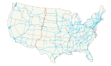
CanAm Highway passes through these states
in the United States
; Texas
, New Mexico
, Colorado
, Wyoming
, South Dakota
, North Dakota
, as well as the province
of Saskatchewan
, Canada
. The international Can-Am Highway travels along U.S. Route 85
and Interstate 25, connecting Mexico
to Canada
through the United States
. The CanAm highway in Canada comprises Saskatchewan Highways SK 35
, SK 39
, SK 6
, SK 3
, and SK 2
. The route continues south in Mexico as Mexican Federal Highway 45
, and north as SK 102
but are not labeled the CanAm highway.
NAFTA super corridors are a concept of huge transportation corridors connecting Mexico, United States, and Canada. The CanAm highway was a concept begun in the 1920s.
U.S. state
A U.S. state is any one of the 50 federated states of the United States of America that share sovereignty with the federal government. Because of this shared sovereignty, an American is a citizen both of the federal entity and of his or her state of domicile. Four states use the official title of...
in the United States
United States
The United States of America is a federal constitutional republic comprising fifty states and a federal district...
; Texas
Texas
Texas is the second largest U.S. state by both area and population, and the largest state by area in the contiguous United States.The name, based on the Caddo word "Tejas" meaning "friends" or "allies", was applied by the Spanish to the Caddo themselves and to the region of their settlement in...
, New Mexico
New Mexico
New Mexico is a state located in the southwest and western regions of the United States. New Mexico is also usually considered one of the Mountain States. With a population density of 16 per square mile, New Mexico is the sixth-most sparsely inhabited U.S...
, Colorado
Colorado
Colorado is a U.S. state that encompasses much of the Rocky Mountains as well as the northeastern portion of the Colorado Plateau and the western edge of the Great Plains...
, Wyoming
Wyoming
Wyoming is a state in the mountain region of the Western United States. The western two thirds of the state is covered mostly with the mountain ranges and rangelands in the foothills of the Eastern Rocky Mountains, while the eastern third of the state is high elevation prairie known as the High...
, South Dakota
South Dakota
South Dakota is a state located in the Midwestern region of the United States. It is named after the Lakota and Dakota Sioux American Indian tribes. Once a part of Dakota Territory, South Dakota became a state on November 2, 1889. The state has an area of and an estimated population of just over...
, North Dakota
North Dakota
North Dakota is a state located in the Midwestern region of the United States of America, along the Canadian border. The state is bordered by Canada to the north, Minnesota to the east, South Dakota to the south and Montana to the west. North Dakota is the 19th-largest state by area in the U.S....
, as well as the province
Province
A province is a territorial unit, almost always an administrative division, within a country or state.-Etymology:The English word "province" is attested since about 1330 and derives from the 13th-century Old French "province," which itself comes from the Latin word "provincia," which referred to...
of Saskatchewan
Saskatchewan
Saskatchewan is a prairie province in Canada, which has an area of . Saskatchewan is bordered on the west by Alberta, on the north by the Northwest Territories, on the east by Manitoba, and on the south by the U.S. states of Montana and North Dakota....
, Canada
Canada
Canada is a North American country consisting of ten provinces and three territories. Located in the northern part of the continent, it extends from the Atlantic Ocean in the east to the Pacific Ocean in the west, and northward into the Arctic Ocean...
. The international Can-Am Highway travels along U.S. Route 85
U.S. Route 85
U.S. Route 85 is a north–south United States highway that runs for in the Mountain - Northern Plains states of the United States. The southern terminus of the route is at the United States-Mexico border in El Paso, Texas, connecting with Mexican Federal Highway 45...
and Interstate 25, connecting Mexico
Mexico
The United Mexican States , commonly known as Mexico , is a federal constitutional republic in North America. It is bordered on the north by the United States; on the south and west by the Pacific Ocean; on the southeast by Guatemala, Belize, and the Caribbean Sea; and on the east by the Gulf of...
to Canada
Canada
Canada is a North American country consisting of ten provinces and three territories. Located in the northern part of the continent, it extends from the Atlantic Ocean in the east to the Pacific Ocean in the west, and northward into the Arctic Ocean...
through the United States
United States
The United States of America is a federal constitutional republic comprising fifty states and a federal district...
. The CanAm highway in Canada comprises Saskatchewan Highways SK 35
Saskatchewan Highway 35
Highway 35 is a paved undivided provincial highway in the Canadian province of Saskatchewan. It runs from the US Border near Port of Oungre to a dead end near the north shore of Tobin Lake. Saskatchewan Highway 35 SK Hwy 35) is about long. The CanAm Highway comprises Saskatchewan Highways 35,...
, SK 39
Saskatchewan Highway 39
Highway 39 is a provincial paved undivided highway located in the southern portion of the Canadian province of Saskatchewan connecting North Portal and Moose Jaw in the north. This is a primary Saskatchewan highway maintained by the provincial and national governments providing a major trucking...
, SK 6
Saskatchewan Highway 6
Highway 6 is a paved undivided major provincial highway in the Canadian province of Saskatchewan. It runs from Montana Highway 16 at the Saskatchewan border with the US near the Canada customs port of Regway to Highway 55 near Choiceland. Highway 6 is about long. The CanAm Highway comprises ...
, SK 3
Saskatchewan Highway 3
Highway 3 is a major provincial paved undivided highway in the Canadian province of Saskatchewan. It runs from the Alberta border, continues west as Alberta Highway 45 to the Manitoba border, and then continues east as Highway 77. Highway 3 is about 615 km long. The CanAm Highway comprises ...
, and SK 2
Saskatchewan Highway 2
Highway 2 is a provincial highway in the Canadian province of Saskatchewan. It is the longest Saskatchewan Highway, at 809 km . The highway is partially divided and undivided. However, only about near Moose Jaw, near Chamberlain, and near Prince Albert are divided highway...
. The route continues south in Mexico as Mexican Federal Highway 45
Mexican Federal Highway 45
Mexican Federal Highway 45 connects Ciudad Juárez, Chihuahua, to Panales, Hidalgo.It is located in the north of Mexico connecting Portezuelo in Hidalgo to Ciudad Juárez in Chihuahua...
, and north as SK 102
Saskatchewan Highway 102
Highway 102 is a highway in the Canadian province of Saskatchewan. It runs from Highway 2 at La Ronge and Lac La Ronge Provincial Park to Southend, at Reindeer Lake. Highway 102 is about 216 km long, the majority of which is gravel surface....
but are not labeled the CanAm highway.
History
North American Free Trade AgreementNorth American Free Trade Agreement
The North American Free Trade Agreement or NAFTA is an agreement signed by the governments of Canada, Mexico, and the United States, creating a trilateral trade bloc in North America. The agreement came into force on January 1, 1994. It superseded the Canada – United States Free Trade Agreement...
NAFTA super corridors are a concept of huge transportation corridors connecting Mexico, United States, and Canada. The CanAm highway was a concept begun in the 1920s.
Highway Links
See also
- U.S. Route 85U.S. Route 85U.S. Route 85 is a north–south United States highway that runs for in the Mountain - Northern Plains states of the United States. The southern terminus of the route is at the United States-Mexico border in El Paso, Texas, connecting with Mexican Federal Highway 45...
- SK 35Saskatchewan Highway 35Highway 35 is a paved undivided provincial highway in the Canadian province of Saskatchewan. It runs from the US Border near Port of Oungre to a dead end near the north shore of Tobin Lake. Saskatchewan Highway 35 SK Hwy 35) is about long. The CanAm Highway comprises Saskatchewan Highways 35,...
- SK 39Saskatchewan Highway 39Highway 39 is a provincial paved undivided highway located in the southern portion of the Canadian province of Saskatchewan connecting North Portal and Moose Jaw in the north. This is a primary Saskatchewan highway maintained by the provincial and national governments providing a major trucking...
- SK 6Saskatchewan Highway 6Highway 6 is a paved undivided major provincial highway in the Canadian province of Saskatchewan. It runs from Montana Highway 16 at the Saskatchewan border with the US near the Canada customs port of Regway to Highway 55 near Choiceland. Highway 6 is about long. The CanAm Highway comprises ...
- SK 3Saskatchewan Highway 3Highway 3 is a major provincial paved undivided highway in the Canadian province of Saskatchewan. It runs from the Alberta border, continues west as Alberta Highway 45 to the Manitoba border, and then continues east as Highway 77. Highway 3 is about 615 km long. The CanAm Highway comprises ...
- SK 2Saskatchewan Highway 2Highway 2 is a provincial highway in the Canadian province of Saskatchewan. It is the longest Saskatchewan Highway, at 809 km . The highway is partially divided and undivided. However, only about near Moose Jaw, near Chamberlain, and near Prince Albert are divided highway...