

San Joaquin (soil)
Encyclopedia
Insignia
Insignia or insigne pl -nia or -nias : a symbol or token of personal power, status or office, or of an official body of government or jurisdiction...
, the State Soil of the U.S. state
U.S. state
A U.S. state is any one of the 50 federated states of the United States of America that share sovereignty with the federal government. Because of this shared sovereignty, an American is a citizen both of the federal entity and of his or her state of domicile. Four states use the official title of...
of California
California
California is a state located on the West Coast of the United States. It is by far the most populous U.S. state, and the third-largest by land area...
.
The California Central Valley
California Central Valley
California's Central Valley is a large, flat valley that dominates the central portion of California. It is home to California's most productive agricultural efforts. The valley stretches approximately from northwest to southeast inland and parallel to the Pacific Ocean coast. Its northern half is...
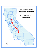
has more than 500,000 acres (2,000 km²) of San Joaquin soils, named for the south end of that valley. This series is the oldest continuously recognized soil series
Soil series
Soil series as established by the National Cooperative Soil Survey of the United States Department of Agriculture Natural Resources Conservation Service are a level of classification in the USDA Soil Taxonomy classification system hierarchy. The actual object of classification is the so-called...
within the State. It is one of California's Benchmark Soils, and a soil profile of it is displayed in the International Soil Reference and Information Centre
International Soil Reference and Information Centre
World Soil Information, established in 1964 is an independent foundation with a global mandate, funded by the Netherlands Government, and with a strategic association with Wageningen University and Research Centre.Our aims:...
's World Soil Museum.
The San Joaquin series became the Official State Soil on August 20, 1997, the result of efforts by students and teachers from Martin Luther King, Jr. Middle School in Madera, natural resource professionals, the Professional Soil Scientists Association of California, legislators, and various state universities.
These soils are used for irrigated crops
Crop (agriculture)
A crop is a non-animal species or variety that is grown to be harvested as food, livestock fodder, fuel or for any other economic purpose. Major world crops include maize , wheat, rice, soybeans, hay, potatoes and cotton. While the term "crop" most commonly refers to plants, it can also include...
, such as wheat
Wheat
Wheat is a cereal grain, originally from the Levant region of the Near East, but now cultivated worldwide. In 2007 world production of wheat was 607 million tons, making it the third most-produced cereal after maize and rice...
, rice
Rice
Rice is the seed of the monocot plants Oryza sativa or Oryza glaberrima . As a cereal grain, it is the most important staple food for a large part of the world's human population, especially in East Asia, Southeast Asia, South Asia, the Middle East, and the West Indies...
, figs
Ficus
Ficus is a genus of about 850 species of woody trees, shrubs, vines, epiphytes, and hemiepiphyte in the family Moraceae. Collectively known as fig trees or figs, they are native throughout the tropics with a few species extending into the semi-warm temperate zone. The Common Fig Ficus is a genus of...
, almonds, oranges
Orange (fruit)
An orange—specifically, the sweet orange—is the citrus Citrus × sinensis and its fruit. It is the most commonly grown tree fruit in the world....
, and grapes, and for pasture
Pasture
Pasture is land used for grazing. Pasture lands in the narrow sense are enclosed tracts of farmland, grazed by domesticated livestock, such as horses, cattle, sheep or swine. The vegetation of tended pasture, forage, consists mainly of grasses, with an interspersion of legumes and other forbs...
and urban development
City region
The term city region has been in use since about 1950 by urbanists, economists and urban planners to mean a metropolitan area and hinterland which has a shared and formal administrative government...
. San Joaquin soils formed in old alluvium
Alluvium
Alluvium is loose, unconsolidated soil or sediments, eroded, deposited, and reshaped by water in some form in a non-marine setting. Alluvium is typically made up of a variety of materials, including fine particles of silt and clay and larger particles of sand and gravel...
on hummocky topography. A cemented hardpan
Hardpan
In soil science, agriculture and gardening, hardpan or ouklip is a general term for a dense layer of soil, usually found below the uppermost topsoil layer. There are different types of hardpan, all sharing the general characteristic of being a distinct soil layer that is largely impervious to water...
a few feet beneath the surface restricts root
Root
In vascular plants, the root is the organ of a plant that typically lies below the surface of the soil. This is not always the case, however, since a root can also be aerial or aerating . Furthermore, a stem normally occurring below ground is not exceptional either...
s and water percolation.
San Joaquin soils are classified
Soil classification
Soil classification deals with the systematic categorization of soils based on distinguishing characteristics as well as criteria that dictate choices in use.- Overview :...
in USDA soil taxonomy
USDA soil taxonomy
USDA Soil Taxonomy developed by United States Department of Agriculture and the National Cooperative Soil Survey provides an elaborate classification of soil types according to several parameters and in several levels: Order, Suborder, Great Group, Subgroup, Family, and Series.- Example of...
as fine, mixed, active, thermic abruptic durixeralfs.
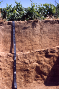
Soil profile
- Surface layer is brown loamSoil colorSoil colour does not affect the behavior and use of soil, however it can indicate the composition of the soil and give clues to the conditions that the soil is subjected to....
. - Upper subsoilSubsoilSubsoil, or substrata, is the layer of soil under the topsoil on the surface of the ground. The subsoil may include substances such as clay and/or sand that has only been partially broken down by air, sunlight, water, wind etc., to produce true soil...
is brown loam, lower subsoil is brown clay. - Substratum is light brown and brown, indurated duripan with 70 to 90 percent silica-sesquioxide cementation.
Legislative history
The billBill (proposed law)
A bill is a proposed law under consideration by a legislature. A bill does not become law until it is passed by the legislature and, in most cases, approved by the executive. Once a bill has been enacted into law, it is called an act or a statute....
that designated the San Joaquin Soil as the official State Soil of California (SB-389) began its journey through legislative channels of the California State Legislature
California State Legislature
The California State Legislature is the state legislature of the U.S. state of California. It is a bicameral body consisting of the lower house, the California State Assembly, with 80 members, and the upper house, the California State Senate, with 40 members...
early in 1997.
The energy that propelled the San Joaquin Soil to being formally designated the "Official State Soil" -- was that of Alex Lehman, who saw an opportunity to provide his Madera, California
Madera, California
Madera is a city in and the county seat of Madera County, California, United States. It is a principal city of the Madera–Chowchilla Metropolitan Statistical Area, which encompasses all of Madera County, and Metropolitan Fresno. It is located in California's San Joaquin Valley. As of the 2010...
Martin Luther King, Jr. Middle School
Middle school
Middle School and Junior High School are levels of schooling between elementary and high schools. Most school systems use one term or the other, not both. The terms are not interchangeable...
students with a meaningful endeavor which allowed an integrated curriculum approach. Mr. Lehman solicited the assistance of a State Senator, the Honorable Dick Monteith, as well as the Professional Soil Scientists Association of California (PSSAC). The concept to designate the San Joaquin Soil as the official soil of California began a number of years ago when Gordon Huntington, and several other PSSAC members suggested that designating an official State Soil would be a worthwhile goal of the association, which conducted research and prepared supporting documentation. Mr. Lehman and his students approached Senator Monteith with PSSAC's documentation, including appropriate maps and soil description. The students had also done their own research on other states already having an official state soil. Senator Monteith was impressed and agreed to assist with the class's project.
SB 389's journey began on February 14, 1997. It passed via amendment in the California State Senate
California State Senate
The California State Senate is the upper house of the California State Legislature. There are 40 state senators. The state legislature meets in the California State Capitol in Sacramento. The Lieutenant Governor is the ex officio President of the Senate and may break a tied vote...
on March 20, 1997 and the California State Assembly
California State Assembly
The California State Assembly is the lower house of the California State Legislature. There are 80 members in the Assembly, representing an approximately equal number of constituents, with each district having a population of at least 420,000...
on July 21, 1997. From there it went to the California Governor
Governor of California
The Governor of California is the chief executive of the California state government, whose responsibilities include making annual State of the State addresses to the California State Legislature, submitting the budget, and ensuring that state laws are enforced...
's desk and was signed into California Government Code
Statutory law
Statutory law or statute law is written law set down by a legislature or by a legislator .Statutes may originate with national, state legislatures or local municipalities...
on August 20, 1997 by Governor Pete Wilson
Pete Wilson
Peter Barton "Pete" Wilson is an American politician from California. Wilson, a Republican, served as the 36th Governor of California , the culmination of more than three decades in the public arena that included eight years as a United States Senator , eleven years as Mayor of San Diego and...
.
History of recognition
The history of recognition and the development of the San Joaquin soilSoil
Soil is a natural body consisting of layers of mineral constituents of variable thicknesses, which differ from the parent materials in their morphological, physical, chemical, and mineralogical characteristics...
dates from the turn of the 20th century. Field operations of the United States Soil Survey, now known as the National Cooperative Soil Survey
National Cooperative Soil Survey
The National Cooperative Soil Survey in the United States is a nation-wide partnership of federal, regional, state, and local agencies and institutions...
, began in 1899. The San Joaquin soil was initially documented and officially established in 1900 as one of the first four soil series
Soil series
Soil series as established by the National Cooperative Soil Survey of the United States Department of Agriculture Natural Resources Conservation Service are a level of classification in the USDA Soil Taxonomy classification system hierarchy. The actual object of classification is the so-called...
recognized in California by the survey All were considered to have agricultural importance. Since then, three of these series have either been dropped from the official listings or have been combined with other soil series
Soil series
Soil series as established by the National Cooperative Soil Survey of the United States Department of Agriculture Natural Resources Conservation Service are a level of classification in the USDA Soil Taxonomy classification system hierarchy. The actual object of classification is the so-called...
recognized at a later date. Thus, the San Joaquin soil is the oldest, continuously recognized soil series within the state. (More than 1,500 soil series are currently recognized in California.) Nearly one-half million acres (2,000 km²) of this soil have now been identified and mapped in many counties in California. With proper management, this soil has produced many millions of dollars of agricultural wealth for the state's economy. Knowledge of the San Joaquin soil's properties and characteristics has become increasingly important in suburban and urban development. As the science of soil
Soil science
Soil science is the study of soil as a natural resource on the surface of the earth including soil formation, classification and mapping; physical, chemical, biological, and fertility properties of soils; and these properties in relation to the use and management of soils.Sometimes terms which...
has advanced during this century, the concept of the San Joaquin soil has evolved, but has retained, as distinctive soil characteristics
Soil morphology
Soil morphology is the field observable attributes of the soil within the various soil horizons and the description of the kind and arrangement of the horizons. C.F...
, its reddish soil color
Soil color
Soil colour does not affect the behavior and use of soil, however it can indicate the composition of the soil and give clues to the conditions that the soil is subjected to....
and its strongly cemented subsoil
Subsoil
Subsoil, or substrata, is the layer of soil under the topsoil on the surface of the ground. The subsoil may include substances such as clay and/or sand that has only been partially broken down by air, sunlight, water, wind etc., to produce true soil...
hardpan that limits root and water penetration. Aside from the texture
Soil texture
Soil texture is a qualitative classification tool used in both the field and laboratory to determine classes for agricultural soils based on their physical texture. The classes are distinguished in the field by the 'textural feel' which can be further clarified by separating the relative...
and structure
Soil structure
Soil structure is determined by how individual soil granules clump or bind together and aggregate, and therefore, the arrangement of soil pores between them...
of the surface soil
Topsoil
Topsoil is the upper, outermost layer of soil, usually the top to . It has the highest concentration of organic matter and microorganisms and is where most of the Earth's biological soil activity occurs.-Importance:...
, the early descriptions of the San Joaquin soil paid little attention to the physical character of the subsoil
Subsoil
Subsoil, or substrata, is the layer of soil under the topsoil on the surface of the ground. The subsoil may include substances such as clay and/or sand that has only been partially broken down by air, sunlight, water, wind etc., to produce true soil...
above the hardpan
Hardpan
In soil science, agriculture and gardening, hardpan or ouklip is a general term for a dense layer of soil, usually found below the uppermost topsoil layer. There are different types of hardpan, all sharing the general characteristic of being a distinct soil layer that is largely impervious to water...
. The hardpan was expected to be encountered within a depth of 6 feet. The modern concept recognizes mainly a sandy loam surface soil overlying a finer textured subsoil that has a significant clay
Clay
Clay is a general term including many combinations of one or more clay minerals with traces of metal oxides and organic matter. Geologic clay deposits are mostly composed of phyllosilicate minerals containing variable amounts of water trapped in the mineral structure.- Formation :Clay minerals...
increase, at its upper boundary or within some part of the subsoil. The subsoil rests abruptly on a mainly silica-cemented hardpan at depths ranging from 20 to 40 inches. With these features, plus defined ranges of other surface and subsoil properties such as color
Soil color
Soil colour does not affect the behavior and use of soil, however it can indicate the composition of the soil and give clues to the conditions that the soil is subjected to....
, soil texture
Soil texture
Soil texture is a qualitative classification tool used in both the field and laboratory to determine classes for agricultural soils based on their physical texture. The classes are distinguished in the field by the 'textural feel' which can be further clarified by separating the relative...
, structure, consistence, pH
Soil pH
The soil pH is a measure of the acidity or basicity in soils. pH is defined as the negative logarithm of the activity of hydrogen ions in solution. It ranges from 0 to 14, with 7 being neutral. A pH below 7 is acidic and above 7 is basic. Soil pH is considered a master variable in soils as it...
, organic matter
Soil organic matter
Organic matter is matter that has come from a once-living organism; is capable of decay, or the product of decay; or is composed of organic compounds...
content, and inherent temperature and moisture characteristics, USDA soil taxonomy
USDA soil taxonomy
USDA Soil Taxonomy developed by United States Department of Agriculture and the National Cooperative Soil Survey provides an elaborate classification of soil types according to several parameters and in several levels: Order, Suborder, Great Group, Subgroup, Family, and Series.- Example of...
now places the San Joaquin series in a fine, mixed, thermic family of Abruptic Durixeralfs. The San Joaquin soil was first recognized in the survey of the Fresno Area in 1900.
At that time it was mapped as San Joaquin sandy loam on the "Red Formation" and characterized as being underlain by a "red sandstone hardpan." The soil was described as having a hog wallow (mound
Mound
A mound is a general term for an artificial heaped pile of earth, gravel, sand, rocks, or debris. The most common use is in reference to natural earthen formation such as hills and mountains, particularly if they appear artificial. The term may also be applied to any rounded area of topographically...
and swale
Swale (geographical feature)
A swale is a low tract of land, especially one that is moist or marshy. The term can refer to a natural landscape feature or a human-created one...
) relief
Topography
Topography is the study of Earth's surface shape and features or those ofplanets, moons, and asteroids...
. The depth to hardpan ranged from 1 foot to 6 feet. The cementing agent
Cement (geology)
The term cement in geology means the fine-grained minerals which bind the coarser-grained matrix in sedimentary rocks.Such cements are typically composed of calcite, quartz or clay minerals....
for the hard pan was thought to be ferric
Ferric
Ferric refers to iron-containing materials or compounds. In chemistry the term is reserved for iron with an oxidation number of +3, also denoted iron or Fe3+. On the other hand, ferrous refers to iron with oxidation number of +2, denoted iron or Fe2+...
hydrate
Hydrate
Hydrate is a term used in inorganic chemistry and organic chemistry to indicate that a substance contains water. The chemical state of the water varies widely between hydrates, some of which were so labeled before their chemical structure was understood....
with some lime
Lime (mineral)
Lime is a general term for calcium-containing inorganic materials, in which carbonates, oxides and hydroxides predominate. Strictly speaking, lime is calcium oxide or calcium hydroxide. It is also the name for a single mineral of the CaO composition, occurring very rarely...
carbonates and probably silica. About 74,500 acres (301 km²) were mapped. The San Joaquin soil was next mapped in the Modesto-Turlock Area in 1909. and was described as having a "brick red" surface layer that was underlain by a "ferruginous
Ferruginous
Ferruginous can refer to:* Iron oxide* Ferruginous bodies* Ferruginous Hawk* Ferruginous Duck...
hardpan" at depths of 15 to 60 inches. A red clay loam layer above the hardpan was recognized. About 90,000 acres (360 km²) were mapped. In 1911, the San Joaquin soil was mapped in the Madera
Madera County, California
Madera County is a county of the U.S. state of California, located in the Central Valley and the Sierra Nevada north of Fresno County. It comprises the Madera-Chowchilla, CA Metropolitan Statistical Area. As of the 2010 census the population was 150,865...
Area. The concept of the soil did not change in this survey. It was noted that the soil became saturated during the rainy season and became boggy and impassable except for well traveled roads. About 138,000 acres (558 km²) were mapped.The San Joaquin soil was again mapped in the 1914 update of the Fresno Area.
The concept of the soil did not change significantly from that of the original survey in 1900, but sandy loam and clay loam types were recognized. In addition, an increase in clay content of the subsoil above the hardpan was described in some places. Where the hardpan was less than 30 inches deep, it was noted that it was necessary to fracture the hardpan by blasting to grow fruit trees. There were about 127,000 acres (514 km²) mapped. In the 1915 Reconnaissance Soil Survey of the Sacramento Valley, California by L.C. Holmes, et al., heavier (finer) textures, either clay loams or clays, were described as normally intervening between the surface soil and the hardpan in the San Joaquin soil San Joaquin soils mapped in the Reconnaissance Soil Surveys of the San Joaquin Valley
San Joaquin Valley
The San Joaquin Valley is the area of the Central Valley of California that lies south of the Sacramento – San Joaquin River Delta in Stockton...
and Southern California
Southern California
Southern California is a megaregion, or megapolitan area, in the southern area of the U.S. state of California. Large urban areas include Greater Los Angeles and Greater San Diego. The urban area stretches along the coast from Ventura through the Southland and Inland Empire to San Diego...
in 1915 to 1919 were similarly described. San Joaquin soil identified in Southern California at that time have subsequently been correlated with other similar, but pedologically different soils.
During the 1920s and 1930s nine new soil survey
Soil survey
Soil survey, or soil mapping, is the process of classifying soil types and other soil properties in a given area and geo-encoding such information. It applies the principles of soil science, and draws heavily from geomorphology, theories of soil formation, physical geography, and analysis of...
s remapped, in greater detail, much of the area covered earlier by the Reconnaissance Soil Surveys of the San Joaquin and Sacramento Valleys. For the most part, but not entirely, these surveys confined their recognition of San Joaquin soils to those areas of reddish hardpan soils having a clayey subsoil resting on the hardpan. For a period of time, a very similar soil was recognized as the Rocklin series which differed from the San Joaquin series only in having thick, consolidated sediments beneath its hardpan, opposed to looser sediments beneath the San Joaquin hardpan. This was considered to be of practical importance in modifying these soils for deep rooted crops.
By the late 1930s and early 1940s, this concept was dropped and the Rocklin soil redefined as a reddish hardpan soil having a distinct subsoil above its hardpan, but lacking a clay pan. The character of the materials beneath the hardpans of either soil was no longer a differentiating feature since consistent determination in mapping was not feasible.The Soil Manual for the Eleventh Farm Credit District, USDA, dated September 1, 1941, described the following concept of the San Joaquin soil: "As mapped in the past (San Joaquin soil) probably included several series. As presently defined (this soil) occupies old terraces, fans
Alluvial fan
An alluvial fan is a fan-shaped deposit formed where a fast flowing stream flattens, slows, and spreads typically at the exit of a canyon onto a flatter plain. A convergence of neighboring alluvial fans into a single apron of deposits against a slope is called a bajada, or compound alluvial...
, and valley
Valley
In geology, a valley or dale is a depression with predominant extent in one direction. A very deep river valley may be called a canyon or gorge.The terms U-shaped and V-shaped are descriptive terms of geography to characterize the form of valleys...
plains of granitic origin, mainly on the east side of the San Joaquin and Sacramento Valleys. Topography
Topography
Topography is the study of Earth's surface shape and features or those ofplanets, moons, and asteroids...
- sloping to undulating with 'hog wallow' microrelief. Reddish brown topsoil over heavier (finer textured) subsoil containing an iron-cemented hardpan
Ferricrete
Ferricrete is a hard, erosion-resistant layer of material at the land surface that consists of near surface sediments cemented by iron oxide in to a duricrust. Ferricretes contains sediments and other non-indigenous materials, which have been transported from outside the immediate area in which it...
. Redder in the surface and denser hardpan than associated Madera soil. Used mostly for pasture
Pasture
Pasture is land used for grazing. Pasture lands in the narrow sense are enclosed tracts of farmland, grazed by domesticated livestock, such as horses, cattle, sheep or swine. The vegetation of tended pasture, forage, consists mainly of grasses, with an interspersion of legumes and other forbs...
and for dry-farmed grain
GRAIN
GRAIN is a small international non-profit organisation that works to support small farmers and social movements in their struggles for community-controlled and biodiversity-based food systems. Our support takes the form of independent research and analysis, networking at local, regional and...
. Some fruit
Fruit
In broad terms, a fruit is a structure of a plant that contains its seeds.The term has different meanings dependent on context. In non-technical usage, such as food preparation, fruit normally means the fleshy seed-associated structures of certain plants that are sweet and edible in the raw state,...
and other crops
Crop (agriculture)
A crop is a non-animal species or variety that is grown to be harvested as food, livestock fodder, fuel or for any other economic purpose. Major world crops include maize , wheat, rice, soybeans, hay, potatoes and cotton. While the term "crop" most commonly refers to plants, it can also include...
grown with fair success where irrigated."
Further description of a San Joaquin soil profile was given in the Soil Manual as follows: "The surface soil reported as a reddish brown, gritty sandy loam about 14 inches thick. The subsoil reported as a sticky and very plastic, brownish red sandy clay loam about 10 inches thick resting abruptly on a red or brownish red, indurated hardpan.The oldest official description of the San Joaquin Valley series, filed with the Soil Conservation Service, was dated January 1941, and revised August 1952. The concept was similar to that used by the Eleventh Farm Credit District except that the subsoil was described as a sandy clay with an abrupt upper and lower boundary. This was the first official description that approached the modern concept of the San Joaquin series. Subsequent field and laboratory studies have led to further revisions and to the present concept given in the 1996 series description.In 1983, the type location for the San Joaquin soil was relocated to a site north of Lodi, California
Lodi, California
Lodi is a city located in , in the northern portion of California's Central Valley. The population was 62,134 at the 2010 census. The California Department of Finance's population estimate as of January 1, 2011 is 62,473....
, in San Joaquin county. At that time, a monolith (a preserved 5 foot profile section) of the San Joaquin soil was prepared for this site and sent to the Netherlands World Soil Museum in Wageningen, Holland. Previously, the San Joaquin soil had been selected by the Soil Conservation Service as one of California's Benchmark Soils. "Benchmark Soils" is a nationwide listing of soil series considered representative of soils in Major Land Resource Areas (MLRA) in the United States.Modern soil survey maps now show the distribution of San Joaquin Soil of California in Fresno
Fresno County, California
Fresno County is a county located in the Central Valley of the U.S. state of California, south of Stockton and north of Bakersfield. As of the 2010 census, it is the tenth most populous county in California with a population of 930,450, and the sixth largest in size with an area of . The county...
, Madera
Madera County, California
Madera County is a county of the U.S. state of California, located in the Central Valley and the Sierra Nevada north of Fresno County. It comprises the Madera-Chowchilla, CA Metropolitan Statistical Area. As of the 2010 census the population was 150,865...
, Mariposa
Mariposa County, California
Mariposa County is a county in the U.S. state of California, located in the western foothills of the Sierra Nevada mountains. It lies north of Fresno, east of Merced, and southeast of Stockton. As of the 2010 census, the population was 18,251 up from 17,130 at the 2000 census...
, Merced
Merced County, California
Merced County , is a county located in the Central Valley of the U.S. state of California, north of Fresno and southeast of San Jose. As of the 2010 census, the population was 255,793, up from 210,554 at the 2000 census. The county seat is Merced...
, Placer
Placer County, California
Placer County is a county located in both the Sacramento Valley and Sierra Nevada regions of the U.S. state of California, in what is known as the Gold Country. It stretches from the suburbs of Sacramento to Lake Tahoe and the Nevada border. Because of the expansion of the Greater Sacramento,...
, Sacramento
Sacramento County, California
Sacramento County is a county in the U.S. state of California. Its county seat is Sacramento, which is also the state capital. As of 2010 the county had a population of 1,418,788....
, San Joaquin
San Joaquin County, California
San Joaquin County is a county located in Central Valley of the U.S. state of California, just east of the San Francisco Bay Area. As of the 2010 census, the population was 685,306. The county seat is Stockton.-History:...
, Stanislaus
Stanislaus County, California
Stanislaus County is a county located in the Central Valley of the U.S. state of California. As the price of housing has increased in the San Francisco Bay Area, many people who work in the southern reaches of the Bay Area have opted for the longer commute and moved to Stanislaus County for the...
, Sutter
Sutter County, California
Sutter County is a county located along the Sacramento River in the Central Valley of the U.S. state of California, north of state capital Sacramento. Sutter County is part of the Greater Sacramento CSA....
, Tulare
Tulare County, California
Tulare County is a county located in the Central Valley of the U.S. state of California, south of Fresno. Sequoia National Park is located in the county, as are part of Kings Canyon National Park, in its northeast corner , and part of Mount Whitney, on its eastern border...
, and Yuba
Yuba County, California
Yuba County is a county located in the U.S. state of California's Central Valley, north of Sacramento, along the Feather River. As of the 2010 census, its population was 72,155. The county seat is Marysville. Yuba County is part of the Greater Sacramento area.-History:Yuba County was one of the...
Counties. They are also located in Butte County
Butte County, California
Butte County is a county located in the Central Valley of the US state of California, north of the state capital of Sacramento. As of the 2010 census, it had a population of 220,000. The county seat is Oroville. Butte County is the "Land of Natural Wealth and Beauty."Butte County is watered by the...
, by an older soil survey.
See also
- AlfisolsAlfisolsAlfisols are a soil order in USDA soil taxonomy. Alfisols form in semiarid to humid areas, typically under a hardwood forest cover. They have a clay-enriched subsoil and relatively high native fertility. "Alf" refers to aluminium and iron . Because of their productivity and abundance, the...
- List of U.S. state soils
- Pedology (soil study)Pedology (soil study)Pedology is the study of soils in their natural environment. It is one of two main branches of soil science, the other being edaphology...
- Soil types
- List of State Soil Science Associations