
Soil survey
Encyclopedia
Soil survey, or soil mapping, is the process of classifying soil type
s and other soil properties in a given area and geo-encoding such information. It applies the principles of soil science
, and draws heavily from geomorphology
, theories of soil formation
, physical geography
, and analysis of vegetation
and land use
patterns. Primary data for the soil survey are acquired by field sampling and by remote sensing
. Remote sensing principally uses aerial photography
but LiDAR
and other digital techniques steadily gaining in popularity. In the past, a soil scientist would take hard-copies of aerial photography, topo-sheets, and mapping keys into the field with them. Today, a growing number of soil scientists are bring a rugidized tablet computer
and GPS into the field with them. The tablet may be loaded with digital aerial photos, LiDAR, topography, soil geodatabases, mapping keys, and more.
The term soil survey may also be used as a noun to describe the published results. In the United States
, these surveys were once published in book form for individual counties by the National Cooperative Soil Survey
. Today, soil surveys are no longer published in book form; they are published to the web and accessed on NRCS Web Soil Survey where a person can create a custom soil survey. This allows for rapid flow of the latest soil information to the user. In the past it could take years to publish a paper soil survey. Today it takes only moments for changes to go live to the public. Also, the most current soil survey data is made available at NRCS Soil Data Mart for high end GIS users such as professional consulting companies and universities.
The information in a soil survey can be used by farmer
s and ranchers to help determine whether a particular soil type is suited for crops
or livestock
and what type of soil management
might be required. An architect
or engineer
might use the engineering properties of a soil to determine whether or not it was suitable for a certain type of construction. A homeowner may even use the information for maintaining or constructing their garden, yard, or home.
.
Soil type
In terms of soil texture, soil type usually refers to the different sizes of mineral particles in a particular sample. Soil is made up in part of finely ground rock particles, grouped according to size as sand, silt and clay...
s and other soil properties in a given area and geo-encoding such information. It applies the principles of soil science
Soil science
Soil science is the study of soil as a natural resource on the surface of the earth including soil formation, classification and mapping; physical, chemical, biological, and fertility properties of soils; and these properties in relation to the use and management of soils.Sometimes terms which...
, and draws heavily from geomorphology
Geomorphology
Geomorphology is the scientific study of landforms and the processes that shape them...
, theories of soil formation
Pedogenesis
Pedogenesis is the science and study of the processes that lead to the formation of soil ' and first explored by the Russian geologist Vasily Dokuchaev , the so called grandfather of soil science, who determined that soil formed over time as a consequence of...
, physical geography
Physical geography
Physical geography is one of the two major subfields of geography. Physical geography is that branch of natural science which deals with the study of processes and patterns in the natural environment like the atmosphere, biosphere and geosphere, as opposed to the cultural or built environment, the...
, and analysis of vegetation
Vegetation
Vegetation is a general term for the plant life of a region; it refers to the ground cover provided by plants. It is a general term, without specific reference to particular taxa, life forms, structure, spatial extent, or any other specific botanical or geographic characteristics. It is broader...
and land use
Land use
Land use is the human use of land. Land use involves the management and modification of natural environment or wilderness into built environment such as fields, pastures, and settlements. It has also been defined as "the arrangements, activities and inputs people undertake in a certain land cover...
patterns. Primary data for the soil survey are acquired by field sampling and by remote sensing
Remote sensing
Remote sensing is the acquisition of information about an object or phenomenon, without making physical contact with the object. In modern usage, the term generally refers to the use of aerial sensor technologies to detect and classify objects on Earth by means of propagated signals Remote sensing...
. Remote sensing principally uses aerial photography
Aerial photography
Aerial photography is the taking of photographs of the ground from an elevated position. The term usually refers to images in which the camera is not supported by a ground-based structure. Cameras may be hand held or mounted, and photographs may be taken by a photographer, triggered remotely or...
but LiDAR
LIDAR
LIDAR is an optical remote sensing technology that can measure the distance to, or other properties of a target by illuminating the target with light, often using pulses from a laser...
and other digital techniques steadily gaining in popularity. In the past, a soil scientist would take hard-copies of aerial photography, topo-sheets, and mapping keys into the field with them. Today, a growing number of soil scientists are bring a rugidized tablet computer
Tablet computer
A tablet computer, or simply tablet, is a complete mobile computer, larger than a mobile phone or personal digital assistant, integrated into a flat touch screen and primarily operated by touching the screen...
and GPS into the field with them. The tablet may be loaded with digital aerial photos, LiDAR, topography, soil geodatabases, mapping keys, and more.
The term soil survey may also be used as a noun to describe the published results. In the United States
United States
The United States of America is a federal constitutional republic comprising fifty states and a federal district...
, these surveys were once published in book form for individual counties by the National Cooperative Soil Survey
National Cooperative Soil Survey
The National Cooperative Soil Survey in the United States is a nation-wide partnership of federal, regional, state, and local agencies and institutions...
. Today, soil surveys are no longer published in book form; they are published to the web and accessed on NRCS Web Soil Survey where a person can create a custom soil survey. This allows for rapid flow of the latest soil information to the user. In the past it could take years to publish a paper soil survey. Today it takes only moments for changes to go live to the public. Also, the most current soil survey data is made available at NRCS Soil Data Mart for high end GIS users such as professional consulting companies and universities.
The information in a soil survey can be used by farmer
Farmer
A farmer is a person engaged in agriculture, who raises living organisms for food or raw materials, generally including livestock husbandry and growing crops, such as produce and grain...
s and ranchers to help determine whether a particular soil type is suited for crops
Agronomy
Agronomy is the science and technology of producing and using plants for food, fuel, feed, fiber, and reclamation. Agronomy encompasses work in the areas of plant genetics, plant physiology, meteorology, and soil science. Agronomy is the application of a combination of sciences like biology,...
or livestock
Livestock
Livestock refers to one or more domesticated animals raised in an agricultural setting to produce commodities such as food, fiber and labor. The term "livestock" as used in this article does not include poultry or farmed fish; however the inclusion of these, especially poultry, within the meaning...
and what type of soil management
Soil management
Soil management concerns all operations, practices and treatments used to protect soil and enhance its performance.-Practices:Soil management practices that affect soil quality:...
might be required. An architect
Architect
An architect is a person trained in the planning, design and oversight of the construction of buildings. To practice architecture means to offer or render services in connection with the design and construction of a building, or group of buildings and the space within the site surrounding the...
or engineer
Engineer
An engineer is a professional practitioner of engineering, concerned with applying scientific knowledge, mathematics and ingenuity to develop solutions for technical problems. Engineers design materials, structures, machines and systems while considering the limitations imposed by practicality,...
might use the engineering properties of a soil to determine whether or not it was suitable for a certain type of construction. A homeowner may even use the information for maintaining or constructing their garden, yard, or home.
Soil survey components
Typical information in a published county soil survey includes the following:- a brief overview of the county's geography
- a general soil map with a brief description of each of the major soil types found in the county along with their characteristics
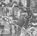
- detailed aerial photographs with specific soil types outlined and indexed
- photographs of some of the typical soils found in the area
- tables containing general information about the various soils such as total area, comparisons of production of typical crops and common range plantsPasturePasture is land used for grazing. Pasture lands in the narrow sense are enclosed tracts of farmland, grazed by domesticated livestock, such as horses, cattle, sheep or swine. The vegetation of tended pasture, forage, consists mainly of grasses, with an interspersion of legumes and other forbs...
. They also include extensive interpretations for Land use planningLand use planningLand-use planning is the term used for a branch of public policy encompassing various disciplines which seek to order and regulate land use in an efficient and ethical way, thus preventing land-use conflicts. Governments use land-use planning to manage the development of land within their...
such as limitations for dwellings with and without basements, shallow excavations, small commercial buildings, septic tank adsorptions, suitability for development, construction, and water management. - tables containing specific physical, chemical, and engineering properties such as soil depth, soil textureSoil textureSoil texture is a qualitative classification tool used in both the field and laboratory to determine classes for agricultural soils based on their physical texture. The classes are distinguished in the field by the 'textural feel' which can be further clarified by separating the relative...
, particle size and distribution, plasticityPlasticity (physics)In physics and materials science, plasticity describes the deformation of a material undergoing non-reversible changes of shape in response to applied forces. For example, a solid piece of metal being bent or pounded into a new shape displays plasticity as permanent changes occur within the...
, permeabilityPermeability (fluid)Permeability in fluid mechanics and the earth sciences is a measure of the ability of a porous material to allow fluids to pass through it.- Units :...
, available water capacityAvailable water capacityAvailable water capacity or available water content is the range of available water that can be stored in soil and be available for growing crops....
, shrink-swell potentialShrink-swell capacityThe Shrink-swell capacity of clay refers to the extent to which a clay will expand when wet and retract when dry. Soil that is problematic due to high capacity is known as shrink-swell soil, or expansive soil.-Description:...
, corrosionCorrosionCorrosion is the disintegration of an engineered material into its constituent atoms due to chemical reactions with its surroundings. In the most common use of the word, this means electrochemical oxidation of metals in reaction with an oxidant such as oxygen...
properties, and erodibilityErosionErosion is when materials are removed from the surface and changed into something else. It only works by hydraulic actions and transport of solids in the natural environment, and leads to the deposition of these materials elsewhere...
.
External links
- A Compendium of On-Line Soil Survey Information
- NRCS Web Soil Survey Inventory of the soil resource across the U.S.
- NRCS Soil Data Mart
- NRCS Helping People Understand Soils
- California Online Soil Survey
- Texas Soil Surveys, hosted by the Portal to Texas History
- Soil Maps of the world European Digital Archive on the Soil Maps of the world
- Historical Soil Surveys of South Carolina at the University of South Carolina Library's Digital Collections Page
.