
River Rivelin
Encyclopedia
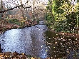
The River Rivelin is a river
in South Yorkshire
, England
.
It rises on the Hallam
moors, north west of Sheffield, and on the outskirts of Sheffield joins the River Loxley
(at Malin Bridge
). The Rivelin Valley, through which the river flows, is a three and a half mile long woodland valley which includes the popular Rivelin Valley Nature Trail that was created in 1967. The valley has farmland on its gentler upper slopes .
A relatively fast flowing river (it drops 80 metres between Rivelin Mill Bridge and Malin Bridge), the Rivelin is fed by a constant release of water from the nearby moorland peat. Its flow was exploited for centuries as a power source, driving the water wheels of up to twenty industries (forges, metal-working and flour mills) along its course.
for deer
hunting. It was known as Rivelin Chase or Firth and covered thousands of acres on the western upland outskirts of the parish of Sheffield. In 1637 John Harrison after surveying the area declared that the firth had an area of 6863 acres (2,777.4 ha). 5531 acres (2,238.3 ha) of this was within Sheffield Parish with the rest in the Parish of Bradfield.
. By 1830 there were two waterwheels powering three grinding stones, however problems with the water supply in the summer meant that the mill was often not working at full capacity. The mill continued operating until the 1930s after which the buildings quickly fell into disrepair and were demolished in the early 1950s with a small car parking area now occupying the site. The dam wall was damaged in 1967 by dredging work and eventually collapsed in March 2001. The RVCG and Sheffield Council filled in the pond and created a new one nearby with a pond dipping platform. The official opening was on 17 May 2007.
and Kingfisher
.
for fishermen; the surrounding area has a large variety of wildlife and there is a picnic area.
in 1874 for using non-union labour.
making farming tools before becoming a wire mill in 1901. In the 1920s it was converted to electrical power. It was one of the last mills in the valley to close as it was still working in the 1950s. The area around the dam has been upgraded for recreational use with a small car park and bench seating. The dam is popular with fishermen and has a large colony of waterfowl
.
s which were greatly commended and won a gold medal at The Great Exhibition
of 1851. It is said that the anvil at Gretna Green
was made by the Mousehole Forge. Production ceased in 1933 and part of the forge is now a private house.
due to the water backing up the valley. The mill stopped production in 1933 with the buildings being demolished in August 1935 for public safety.
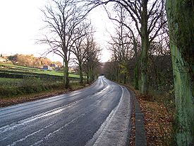
and Rivelin Mill Bridge to connect with the main Sheffield to Manchester
road, now the A57
. Prior to this the valley had no road, just a series of cart tracks connecting the various industrial mills. The building of the road was proposed in 1905 by the local water board, which owned the land; the Duke of Norfolk
also donated 4.5 hectares of his land in the area for the project. Work started in November 1905 and provided employment for 176 unemployed men. The unemployment rate was particularly high at the time and the opportunity to provide work was a contributing factor in making the decision to build the road. Raw materials for the construction of the road were provided by Clough Field quarry on the southern slopes of the valley below Crosspool
. Over 700 lime trees
were purchased from Dixon’s of Chester
in 1906 at a cost of £147. The limes were planted to line the road for a distance of 3.5 miles (5.6 km), making it the second longest lime tree avenue in Britain. The road was opened on 1 September 1907, although work was not completed until June 1908. The final cost of construction was £30,000. Local people quickly christened the road “The New Road”, a name which was still being used many years later. The success of the project in providing work for the unemployed prompted Sheffield Corporation
to press ahead with plans to connect the new road with the Sheffield suburbs of Crookes
and Walkley
. Rivelin Valley Road is now designated as the A6101.
The valley was especially loved by the "corn law rhymer" Ebenezer Elliott
. There is a rock by the side of Black Brook with his name carved on it where he was renowned to sit and appreciate nature. Elliott wrote the lyrical poem
"Farewell To Rivelin" in honour of the valley, with the lines:
. The rocks re-emerge three kilometres further down the valley above the Rivelin Hotel or "The Rivelin" on Tofts Lane. This is the only public house
in the rural part of the valley; the premises were formerly farm buildings before being converted into a pub. Another public house, The Holly Bush, is situated further down the valley, closer to Malin Bridge. One of the most distinguished buildings in the valley is the former King Edward VII Hospital
, a Grade II listed building, the hospital closed in 1992 and has now been converted into apartments. St Michael's Cemetery
, a Catholic
burial ground is situated at the Malin Bridge end of the valley.
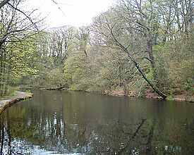
The Rivelin Dams
are two water storage facilities situated in the upper part of the valley just off the A57 road. They provide drinking water for the west and south-west areas of Sheffield. The lower reservoir was built in 1845; it has a surface area of 12 hectares and holds 115,000,000 gallons of water. The smaller upper reservoir was constructed in 1848; it has an area of four hectares and holds 48,400,000 gallons. The Rivelin Water Treatment Works are situated below the reservoirs.
In April 1761, tablets dating from the Roman period were found in the Rivelin Valley south of Stannington
, close to the likely course of the Templeborough
to Brough-on-Noe road. In addition there have been finds dating from the Roman
period on Walkley Bank Road, which leads on to the valley bottom.
River
A river is a natural watercourse, usually freshwater, flowing towards an ocean, a lake, a sea, or another river. In a few cases, a river simply flows into the ground or dries up completely before reaching another body of water. Small rivers may also be called by several other names, including...
in South Yorkshire
South Yorkshire
South Yorkshire is a metropolitan county in the Yorkshire and the Humber region of England. It has a population of 1.29 million. It consists of four metropolitan boroughs: Barnsley, Doncaster, Rotherham, and City of Sheffield...
, England
England
England is a country that is part of the United Kingdom. It shares land borders with Scotland to the north and Wales to the west; the Irish Sea is to the north west, the Celtic Sea to the south west, with the North Sea to the east and the English Channel to the south separating it from continental...
.
It rises on the Hallam
Hallam
-Places:* Hallamshire, an area in South Yorkshire, England; the source of the name for:** Hallam F.C. - a non-league football club in Sheffield.** Hallam FM, a radio station based in Sheffield.** Royal Hallamshire Hospital...
moors, north west of Sheffield, and on the outskirts of Sheffield joins the River Loxley
River Loxley
The River Loxley is a river in the City of Sheffield South Yorkshire, England. Its source is a series of streams which rise some to the north-west of Sheffield on Bradfield Moors, and converge at Low Bradfield...
(at Malin Bridge
Malin Bridge
Malin Bridge is a suburb of the city of Sheffield, England. It is located at grid reference and stands 2½ miles north-west of the city centre where the rivers Loxley and Rivelin meet...
). The Rivelin Valley, through which the river flows, is a three and a half mile long woodland valley which includes the popular Rivelin Valley Nature Trail that was created in 1967. The valley has farmland on its gentler upper slopes .
A relatively fast flowing river (it drops 80 metres between Rivelin Mill Bridge and Malin Bridge), the Rivelin is fed by a constant release of water from the nearby moorland peat. Its flow was exploited for centuries as a power source, driving the water wheels of up to twenty industries (forges, metal-working and flour mills) along its course.
Medieval times
In medieval times the Rivelin valley was part of a large tract of land set aside by the Lords of HallamshireHallamshire
Hallamshire is the historical name for an area of South Yorkshire, England, in the current city of Sheffield.The origin of the name is uncertain. The English Place-Name Society describe "Hallam" originating from a formation meaning "on the rocks"...
for deer
Deer
Deer are the ruminant mammals forming the family Cervidae. Species in the Cervidae family include white-tailed deer, elk, moose, red deer, reindeer, fallow deer, roe deer and chital. Male deer of all species and female reindeer grow and shed new antlers each year...
hunting. It was known as Rivelin Chase or Firth and covered thousands of acres on the western upland outskirts of the parish of Sheffield. In 1637 John Harrison after surveying the area declared that the firth had an area of 6863 acres (2,777.4 ha). 5531 acres (2,238.3 ha) of this was within Sheffield Parish with the rest in the Parish of Bradfield.
Industrial past
The Valley possesses 21 artificially created ponds, testament to the twenty mills which were once present on the river. Though most of the mills and forges no longer exist, the ponds which used to feed them do, thanks to the support of the Rivelin Valley Conservation Group (RVCG) and Yorkshire Water. Some of the more famous mills (from west to east) are as follows:Rivelin Corn Mill
The mostly westerly site, stands at the foot of Rails Road. This mill dates from 1600 when it was owned by Gilbert Talbot, 7th Earl of ShrewsburyGilbert Talbot, 7th Earl of Shrewsbury
Gilbert Talbot, 7th Earl of Shrewsbury, 7th Earl of Waterford, KG was was a peer in the peerage of England.He was the eldest surviving son of George Talbot, 6th Earl of Shrewsbury, by the latter's first marriage to Gertrude Manners, daughter of the first Earl of Rutland.In 1568, Gilbert was...
. By 1830 there were two waterwheels powering three grinding stones, however problems with the water supply in the summer meant that the mill was often not working at full capacity. The mill continued operating until the 1930s after which the buildings quickly fell into disrepair and were demolished in the early 1950s with a small car parking area now occupying the site. The dam wall was damaged in 1967 by dredging work and eventually collapsed in March 2001. The RVCG and Sheffield Council filled in the pond and created a new one nearby with a pond dipping platform. The official opening was on 17 May 2007.
Wolf Wheel
Was built around 1722 and had one of the largest wheels in the valley with a diameter of 15 feet (4.6 m). It was owned by the Windle brothers between 1818 and 1852 who used it for grinding knives and razors, after which it was sold to the Water Company. The mill was in regular use until 1918, but a survey in 1934 revealed that the internal machinery had been dismantled. The pond that served the Wolf Wheel is still in fine condition and has received much attention from the RVCG. It is one of four dams that are used by fishermen in the valley and surrounding wildlife includes DragonflyDragonfly
A dragonfly is a winged insect belonging to the order Odonata, the suborder Epiprocta or, in the strict sense, the infraorder Anisoptera . It is characterized by large multifaceted eyes, two pairs of strong transparent wings, and an elongated body...
and Kingfisher
Kingfisher
Kingfishers are a group of small to medium sized brightly coloured birds in the order Coraciiformes. They have a cosmopolitan distribution, with most species being found in the Old World and Australia...
.
Hind Wheel Mill
This is oldest mill in the valley with a recorded date of 1581 when Thomas Hind, Robert Webster and John Swynden were the owners paying £1 per year rent. It was completely rebuilt around 1820 with production coming around 1930. In October 1936 "The Sheffield Daily Independent" reported that the building had completely disappeared. The present day Round Pond which served the mill is one of the most popular in the area being stocked with troutTrout
Trout is the name for a number of species of freshwater and saltwater fish belonging to the Salmoninae subfamily of the family Salmonidae. Salmon belong to the same family as trout. Most salmon species spend almost all their lives in salt water...
for fishermen; the surrounding area has a large variety of wildlife and there is a picnic area.
Nether Cut Wheel
Situated near the “S” bend on the A6101, the Nether Cut was the last mill to work in the valley; it was still grinding scythes until 1939 and was not demolished until 1956. The mill suffered some unrest and damage during the Sheffield OutragesSheffield Outrages
Sheffield's early success in steel production had involved long working hours, in desperately unpleasant conditions which offered little or no safety protection. quotes a local doctor, Dr. Knight, regarding the so-called "Grinder's Asthma" suffered by the Sheffield cutlery workers in the mid 19th...
in 1874 for using non-union labour.
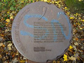
Walkley Bank Tilt
This began as a mill making cutlery around 1750. From 1762 it was a tilt forgeTrip hammer
A trip hammer, also known as a helve hammer, is a massive powered hammer used in:* agriculture to facilitate the labor of pounding, decorticating and polishing of grain;...
making farming tools before becoming a wire mill in 1901. In the 1920s it was converted to electrical power. It was one of the last mills in the valley to close as it was still working in the 1950s. The area around the dam has been upgraded for recreational use with a small car park and bench seating. The dam is popular with fishermen and has a large colony of waterfowl
Waterfowl
Waterfowl are certain wildfowl of the order Anseriformes, especially members of the family Anatidae, which includes ducks, geese, and swans....
.
Mousehole Forge
Located close to Malin Bridge, the forge dates back to 1628 when it was known for iron smelting and bar production. However the forge became world famous for producing anvilAnvil
An anvil is a basic tool, a block with a hard surface on which another object is struck. The inertia of the anvil allows the energy of the striking tool to be transferred to the work piece. In most cases the anvil is used as a forging tool...
s which were greatly commended and won a gold medal at The Great Exhibition
The Great Exhibition
The Great Exhibition of the Works of Industry of all Nations or The Great Exhibition, sometimes referred to as the Crystal Palace Exhibition in reference to the temporary structure in which it was held, was an international exhibition that took place in Hyde Park, London, from 1 May to 15 October...
of 1851. It is said that the anvil at Gretna Green
Gretna Green
Gretna Green is a village in the south of Scotland famous for runaway weddings. It is in Dumfries and Galloway, near the mouth of the River Esk and was historically the first village in Scotland, following the old coaching route from London to Edinburgh. Gretna Green has a railway station serving...
was made by the Mousehole Forge. Production ceased in 1933 and part of the forge is now a private house.
Grogham Wheel
This was the last mill in the valley before the Rivelin's confluence with the River Loxley. It had two waterwheels, with the largest known as “Groggy” being the biggest in the valley. The mill ground files and cutlery and was the only one in the valley to be damaged by the Great Sheffield FloodGreat Sheffield Flood
Not to be confused with the floods in Sheffield in 2007.The Great Sheffield Flood was a flood that devastated parts of Sheffield, England, on 11 March 1864, when the Dale Dyke Dam broke.- Collapse of Dale Dyke Dam :...
due to the water backing up the valley. The mill stopped production in 1933 with the buildings being demolished in August 1935 for public safety.
Rivelin Valley Road
Rivelin Valley Road was built in 1907 between Malin BridgeMalin Bridge
Malin Bridge is a suburb of the city of Sheffield, England. It is located at grid reference and stands 2½ miles north-west of the city centre where the rivers Loxley and Rivelin meet...
and Rivelin Mill Bridge to connect with the main Sheffield to Manchester
Manchester
Manchester is a city and metropolitan borough in Greater Manchester, England. According to the Office for National Statistics, the 2010 mid-year population estimate for Manchester was 498,800. Manchester lies within one of the UK's largest metropolitan areas, the metropolitan county of Greater...
road, now the A57
A57 road
The A57 is a major road in England. It runs east from Liverpool to Lincoln, via Warrington, Cadishead, Irlam, Patricroft, Eccles, Salford and Manchester, then through the Pennines over the Snake Pass , around the Ladybower Reservoir, through Sheffield and past Worksop...
. Prior to this the valley had no road, just a series of cart tracks connecting the various industrial mills. The building of the road was proposed in 1905 by the local water board, which owned the land; the Duke of Norfolk
Duke of Norfolk
The Duke of Norfolk is the premier duke in the peerage of England, and also, as Earl of Arundel, the premier earl. The Duke of Norfolk is, moreover, the Earl Marshal and hereditary Marshal of England. The seat of the Duke of Norfolk is Arundel Castle in Sussex, although the title refers to the...
also donated 4.5 hectares of his land in the area for the project. Work started in November 1905 and provided employment for 176 unemployed men. The unemployment rate was particularly high at the time and the opportunity to provide work was a contributing factor in making the decision to build the road. Raw materials for the construction of the road were provided by Clough Field quarry on the southern slopes of the valley below Crosspool
Crosspool
Crosspool is a suburb of the City of Sheffield, South Yorkshire, England, located west of the city centre. It is a Middle class residential area in an elevated position above the Porter and Rivelin valleys and stands at around 200 metres above sea level...
. Over 700 lime trees
Tilia
Tilia is a genus of about 30 species of trees native throughout most of the temperate Northern Hemisphere. The greatest species diversity is found in Asia, and the genus also occurs in Europe and eastern North America, but not western North America...
were purchased from Dixon’s of Chester
Chester
Chester is a city in Cheshire, England. Lying on the River Dee, close to the border with Wales, it is home to 77,040 inhabitants, and is the largest and most populous settlement of the wider unitary authority area of Cheshire West and Chester, which had a population of 328,100 according to the...
in 1906 at a cost of £147. The limes were planted to line the road for a distance of 3.5 miles (5.6 km), making it the second longest lime tree avenue in Britain. The road was opened on 1 September 1907, although work was not completed until June 1908. The final cost of construction was £30,000. Local people quickly christened the road “The New Road”, a name which was still being used many years later. The success of the project in providing work for the unemployed prompted Sheffield Corporation
Sheffield City Council
Sheffield City Council is the city council for the metropolitan borough of Sheffield in South Yorkshire, England. It consists of 84 councillors, elected to represent 28 wards, each with three councillors...
to press ahead with plans to connect the new road with the Sheffield suburbs of Crookes
Crookes
Crookes ward—which includes the districts of Crookes, Steelbank, Crosspool, and Sandygate —is one of the 28 electoral wards in City of Sheffield, England. It is located in the western part of the city and covers an area of 3.9 km2...
and Walkley
Walkley
Walkley is an electoral ward in Sheffield, South Yorkshire, England.Walkley ward—which includes the districts of Netherthorpe, Upperthorpe, Walkley and parts of Neepsend—is one of the 28 electoral wards in City of Sheffield, England. It is located in the northwestern part of the city...
. Rivelin Valley Road is now designated as the A6101.
The valley was especially loved by the "corn law rhymer" Ebenezer Elliott
Ebenezer Elliott
Ebenezer Elliott was an English poet, known as the Corn Law rhymer.-Early life:Elliott was born at the New Foundry, Masbrough, in the Parish of Rotherham, Yorkshire. His father, was an extreme Calvinist and a strong Radical, and was engaged in the iron trade...
. There is a rock by the side of Black Brook with his name carved on it where he was renowned to sit and appreciate nature. Elliott wrote the lyrical poem
Lyric poetry
Lyric poetry is a genre of poetry that expresses personal and emotional feelings. In the ancient world, lyric poems were those which were sung to the lyre. Lyric poems do not have to rhyme, and today do not need to be set to music or a beat...
"Farewell To Rivelin" in honour of the valley, with the lines:
- Beautiful river! goldenly shining,
- Where, with the cistus, woodbines are twining,
- Birklands around thee, mountains above thee,
- Rivelin wildest! Do I not love thee.
Significant landmarks
As well as industrial heritage, the valley is home to much wildlife, now protected by the Rivelin Valley Conservation Group. The upper part of the valley is flanked to the north by Rivelin RocksRivelin Rocks
Rivelin Rocks are a gritstone edge or escarpment that are situated in the upper Rivelin Valley at grid reference , 9 km west of Sheffield just off the A57 road in the county of South Yorkshire, England, United Kingdom.- Overview :...
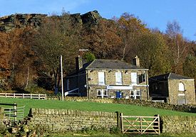
. The rocks re-emerge three kilometres further down the valley above the Rivelin Hotel or "The Rivelin" on Tofts Lane. This is the only public house
Public house
A public house, informally known as a pub, is a drinking establishment fundamental to the culture of Britain, Ireland, Australia and New Zealand. There are approximately 53,500 public houses in the United Kingdom. This number has been declining every year, so that nearly half of the smaller...
in the rural part of the valley; the premises were formerly farm buildings before being converted into a pub. Another public house, The Holly Bush, is situated further down the valley, closer to Malin Bridge. One of the most distinguished buildings in the valley is the former King Edward VII Hospital
King Edward VII Orthopaedic Hospital, Sheffield
The King Edward VII Orthopaedic Hospital is a former hospital in the Rivelin Valley area of Sheffield, England. The hospital closed in 1992 and the building has been converted into residential apartments....
, a Grade II listed building, the hospital closed in 1992 and has now been converted into apartments. St Michael's Cemetery
St Michael's Cemetery, Sheffield
St Michael’s Cemetery is a Catholic burial ground in the Rivelin Valley area of Sheffield, South Yorkshire, England. The cemetery stands on a steep hillside on the south side of Rivelin Valley Road at its junction with Rivelin Road and Hollins Lane.-History:...
, a Catholic
Catholic
The word catholic comes from the Greek phrase , meaning "on the whole," "according to the whole" or "in general", and is a combination of the Greek words meaning "about" and meaning "whole"...
burial ground is situated at the Malin Bridge end of the valley.
The Rivelin Dams
Rivelin Dams
Rivelin Dams are a pair of water storage reservoirs situated in the upper part of the Rivelin Valley, eight km west of Sheffield in South Yorkshire, England. The dams are owned by Yorkshire Water and provide water to 319,000 people as well as compensation water for the River Rivelin...
are two water storage facilities situated in the upper part of the valley just off the A57 road. They provide drinking water for the west and south-west areas of Sheffield. The lower reservoir was built in 1845; it has a surface area of 12 hectares and holds 115,000,000 gallons of water. The smaller upper reservoir was constructed in 1848; it has an area of four hectares and holds 48,400,000 gallons. The Rivelin Water Treatment Works are situated below the reservoirs.
In April 1761, tablets dating from the Roman period were found in the Rivelin Valley south of Stannington
Stannington
Stannington Ward—which includes the districts of Loxley, Stannington, and Worrall, and also the small villages of Dungworth, High Bradfield, and Low Bradfield—is one of the 28 electoral wards in City of Sheffield, England. It is located in the western part of the city and covers an area...
, close to the likely course of the Templeborough
Templeborough
Templeborough is a suburb of Rotherham, South Yorkshire, England. The area takes its name from the remains of the Roman fort found there which were mistakenly believed to be that of a Roman Temple.-Roman fort:...
to Brough-on-Noe road. In addition there have been finds dating from the Roman
Roman Britain
Roman Britain was the part of the island of Great Britain controlled by the Roman Empire from AD 43 until ca. AD 410.The Romans referred to the imperial province as Britannia, which eventually comprised all of the island of Great Britain south of the fluid frontier with Caledonia...
period on Walkley Bank Road, which leads on to the valley bottom.