
River Cart
Encyclopedia
The River Cart is a tributary
of the River Clyde
, Scotland
, which it joins from the west roughly midway between the towns of Erskine
and Renfrew.
The River Cart itself is very short, being formed from the confluence
of the Black Cart Water (from the west) and the White Cart Water (from the south east) and is only 0.75 mile (1 km) long. The River Cart and its tributary the White Cart Water were navigable as far as the Seedhill Craigs at Paisley
; and, as with the River Clyde, various improvements were made to this river navigation.
In 1840 the 0.50 mile (0.8 km) Forth and Cart Canal
was opened, linking the Forth and Clyde Canal
, at Whitecrook
near Clydebank
, to the River Clyde, opposite the mouth of the River Cart. The aim was to provide a direct link between Paisley, Port Dundas
, Edinburgh
, and the Firth of Forth
.
in Lochwinnoch
, Renfrewshire
. From there, it flows northeast to Johnstone
; and then under the M8 motorway at Blackstoun, where it is joined by the River Gryfe
. The river then flows parallel with the main runway of Glasgow International Airport
; passing under the A8 at Renfrew by means of a stone bridge
, where it joins the White Cart Water.
 The White Cart Water originates on the edge of Eaglesham
moor in East Renfrewshire
. It then flows northwards around the south of East Kilbride
to Waterfoot
. The river forms the boundary between East Renfrewshire
and South Lanarkshire
here before running through the centre of the village of Busby
after which it runs around the western side of Clarkston
and Netherlee
where it crosses the Glasgow
city boundary into Linn Park, heading downstream to Cathcart
. Here, the river turns west, flowing through Pollokshaws
and cutting through Pollok Country Park
, under the M77 motorway towards Crookston
, where it is joined by the River Levern
. From Crookston, the river passes the grounds of Leverndale Hospital and then crosses into Renfrewshire
and flows through the farmlands of Hawkhead
, parallel with the Paisley Canal
railway line. On entering the town of Paisley, the river falls over rapids called The Hammills, and flows under two roads, to emerge in the town centre at Paisley Abbey
. It then passes under Gauze Street, the Piazza Shopping Centre and Paisley Gilmour Street railway station
where it emerges from the Abercorn Bridge, a wide, high arch
ed red sandstone
bridge at Old Sneddon Street. From there it runs, mostly hidden from view, towards Glasgow International Airport and Renfrew.
In the town of Paisley the White Cart is joined by a number of tributary streams including the Lady Burn, the St Mirin Burn, the Sneddon Burn and the Espedair Burn. Just outside the burgh boundary, close to Glasgow Airport, the river meets with the Abbot's Burn.
The Greenock
Road (A8), between Inchinnan
and Renfrew, passes over the White Cart Water by means of the Swing Bridge. The White Cart Water then joins with the Black Cart Water, just downstream of the bridge, to become the River Cart.
Robert Burns
' poem The Gallant Weaver mentions the River Cart.
A major flood alleviation scheme is currently under construction by Glasgow City Council to protect vulnerable property on the south side of Glasgow. Designed by Halcrow
the scheme will be the largest flood alleviation project undertaken in Scotland.
has a medieval drain, belonging to the monastery
, which was rediscovered in the 1990s; and excavated by archaeologists. The abbey/monastery drain linked with the White Cart Water both upstream and downstream of the abbey, near to where the Town Hall now stands. The White Cart Water provided both drinking water for the monastery and was used to flush away kitchen
waste and the latrine
s.
A further Act of Parliament
was obtained by the Cart Trust for the river's improvement in 1787, in response to pressure from Paisley's shipbuilders. This led to some improvements around Inchinnan. The first steamer
serviceto Paisley, provided by the Prince of Orange, started in July 1815.
The original Swing Bridge, at Inchinnan, on the Turn Pike
road, now the A8, was opened in 1838; the mechanism for swing bridge was made by Barr and McNab of the Abercorn Foundry, Paisley. A year earlier the, Scotch gauge
, Paisley and Renfrew Railway
had opened between Paisley Hamilton Street
and Renfrew Wharf. The railway was intended to both enhance the capabilities of the River Cart navigation as well as competing against it for goods and passenger traffic. The Cart Trust later went bankrupt.
The Forth and Cart Canal
, opened in 1840, together with the Forth and Clyde Canal
, was intended to provide a direct link between Paisley, Port Dundas
, Edinburgh
, and the Firth of Forth
, without the need to go down the River Clyde to Bowling
and return along the Forth and Clyde Canal to almost the starting point. Its aim was to bring coal
to Paisley.
In January 1866 the Paisley and Renfrew Railway was temporarily closed. When it reopened as a Standard gauge
railway it was linked to the Glasgow and Paisley Joint Railway
at Arkleston Junction
. As a result Hamilton Street station closed.
Paisley's harbour was extended and the re-opening in April 1891 was celebrated by a fleet of steamers sailing from Paisley to Rothesay
.
, attempts were made to buy out the bankrupt Cart Trust; but they resisted these attempts.
The swing bridge at Inchinnan was replaced by the present bridge in 1923; it was made by Sir William Arrol & Co.
It lifts vertically so it is more of a Bascule bridge
than a Swing bridge, but it is still known as the swing bridge. It is still capable of opening, as the Babcock and Wilcox
(now Doosan Babcock
) factory at Renfrew requires the capability to move large loads by river.
Sir William Arrol and Co also made the pedestrian
lifting bridge across the White Cart Water at Carlile Quay (off New Sneddon Street) but this has been disabled from lifting for over 30 years and has been closed to traffic since 1997, the structure being deemed unsafe.
An Act of Parliament was obtained in 1938 by the Ministry of Transport
, the Admiralty
and the Ministry of Shipping. A harbour was built at Laigh Park (Laighpark harbour) at which large cargo boats / ship
s could load and unload; it was linked to the Paisley and Renfrew Railway. This was used extensively during World War II
. Carlile Quay being used for smaller boats. The navigation lights were also upgraded.
The harbour fell into disuse in the 1960s and has been used as a scrapyard for many decades. Carlile Quay has been landscaped, refurbished and made more attractive to pedestrians. Apartment buildings and houses have been built on the vacant site adjacent to the quay.
and industrial effluent
had been discharged untreated into the River Cart via its tributaries: the St Mirin Burn, the Lady Burn, the Sneddon Burn, the Espedair Burn, etc. By 1870 this had led to many complaints about smells and epidemic
s.
"Intercepting sewers" were therefore built on either side of the St Mirin burn to intercept the sewage and discharge it directly into the White Cart Water. Whilst this helped clean up Paisley it did not clean up the River Cart. It led to complaints from Johnstone
, Renfrew
and Glasgow
and calls by them for Paisley to provide a sewage treatment farm. Johnstone, Bridge of Weir
, Lochwinnoch
and Glasgow already had sewage treatment farms. Glasgow's works had begun operations in 1894.
Land at Laigh Park was bought for this purpose between the first and second World Wars although construction work did not start until 1949 with the works opening in 1952. The sewage works were linked to the intercepting sewers and took all of Paisley's sewage and industrial effluent for treatment.
Tributary
A tributary or affluent is a stream or river that flows into a main stem river or a lake. A tributary does not flow directly into a sea or ocean...
of the River Clyde
River Clyde
The River Clyde is a major river in Scotland. It is the ninth longest river in the United Kingdom, and the third longest in Scotland. Flowing through the major city of Glasgow, it was an important river for shipbuilding and trade in the British Empire....
, Scotland
Scotland
Scotland is a country that is part of the United Kingdom. Occupying the northern third of the island of Great Britain, it shares a border with England to the south and is bounded by the North Sea to the east, the Atlantic Ocean to the north and west, and the North Channel and Irish Sea to the...
, which it joins from the west roughly midway between the towns of Erskine
Erskine
Erskine is a town in the council area of Renfrewshire, and historic county of the same name, in the west central Lowlands of Scotland.It lies on the southern bank of the River Clyde, providing the lowest crossing to the north bank of the river at Erskine Bridge connecting the town to Old Kilpatrick...
and Renfrew.
The River Cart itself is very short, being formed from the confluence
Confluence (geography)
In geography, a confluence is the meeting of two or more bodies of water. It usually refers to the point where two streams flow together, merging into a single stream...
of the Black Cart Water (from the west) and the White Cart Water (from the south east) and is only 0.75 mile (1 km) long. The River Cart and its tributary the White Cart Water were navigable as far as the Seedhill Craigs at Paisley
Paisley
Paisley is the largest town in the historic county of Renfrewshire in the west central Lowlands of Scotland and serves as the administrative centre for the Renfrewshire council area...
; and, as with the River Clyde, various improvements were made to this river navigation.
In 1840 the 0.50 mile (0.8 km) Forth and Cart Canal
Forth and Cart Canal
The Forth and Cart Canal was a short 0.5-mile link canal which provided a short cut between the Forth and Clyde Canal, at Whitecrook, and the River Clyde, opposite the mouth of the River Cart. It was intended to provide a transport link between the town of Paisley, the Firth of Forth and Port...
was opened, linking the Forth and Clyde Canal
Forth and Clyde Canal
The Forth and Clyde Canal crosses Scotland, providing a route for sea-going vessels between the Firth of Forth and the Firth of Clyde at the narrowest part of the Scottish Lowlands. The canal is 35 miles long and its eastern end is connected to the River Forth by a short stretch of the River...
, at Whitecrook
Whitecrook
Whitecrook is an area in the southeast of the town of Clydebank, West Dunbartonshire, Greater Glasgow, Scotland, UK. It occupies the area between the Forth and Clyde Canal to the north, and Glasgow Road to the southwest....
near Clydebank
Clydebank
Clydebank is a town in West Dunbartonshire, in the Central Lowlands of Scotland. Situated on the north bank of the River Clyde, Clydebank borders Dumbarton, the town with which it was combined to form West Dunbartonshire, as well as the town of Milngavie in East Dunbartonshire, and the Yoker and...
, to the River Clyde, opposite the mouth of the River Cart. The aim was to provide a direct link between Paisley, Port Dundas
Port Dundas
Port Dundas is an area of Glasgow, Scotland, located to the north of the city centre. It lies to the north of Cowcaddens, and to the west of Sighthill, with Hamiltonhill and Possilpark to the north-west.-History:...
, Edinburgh
Edinburgh
Edinburgh is the capital city of Scotland, the second largest city in Scotland, and the eighth most populous in the United Kingdom. The City of Edinburgh Council governs one of Scotland's 32 local government council areas. The council area includes urban Edinburgh and a rural area...
, and the Firth of Forth
Firth of Forth
The Firth of Forth is the estuary or firth of Scotland's River Forth, where it flows into the North Sea, between Fife to the north, and West Lothian, the City of Edinburgh and East Lothian to the south...
.
Black Cart Water
The Black Cart Water originates at Castle Semple LochCastle Semple Loch
Castle Semple Loch is a 1.5 mile long inland loch at Lochwinnoch in Renfrewshire, Scotland. Originally part of an estate of the same name, it is now administered by Clyde Muirshiel Regional Park as a watersports centre...
in Lochwinnoch
Lochwinnoch
Lochwinnoch is a village in the council area and historic county of Renfrewshire in the west central Lowlands of Scotland. Lying on the banks of Castle Semple Loch and the River Calder, Lochwinnoch is chiefly a residential dormitory village serving nearby urban centres such as Glasgow and Paisley...
, Renfrewshire
Renfrewshire
Renfrewshire is one of 32 council areas used for local government in Scotland. Located in the west central Lowlands, it is one of three council areas contained within the boundaries of the historic county of Renfrewshire, the others being Inverclyde to the west and East Renfrewshire to the east...
. From there, it flows northeast to Johnstone
Johnstone
Johnstone is a town in the council area of Renfrewshire and larger historic county of the same name in the west central Lowlands of Scotland.The town lies three miles west of neighbouring Paisley and twelve miles west of the centre of the city of Glasgow...
; and then under the M8 motorway at Blackstoun, where it is joined by the River Gryfe
River Gryfe
The River Gryfe or River Gryffe is a river and tributary of the Black Cart Water, running through the historic county of Renfrewshire and the modern council areas of Renfrewshire and Inverclyde in the west central Lowlands of Scotland, United Kingdom....
. The river then flows parallel with the main runway of Glasgow International Airport
Glasgow International Airport
Glasgow International Airport is an international airport in Scotland, located west of Glasgow city centre, near the towns of Paisley and Renfrew in Renfrewshire...
; passing under the A8 at Renfrew by means of a stone bridge
Bridge
A bridge is a structure built to span physical obstacles such as a body of water, valley, or road, for the purpose of providing passage over the obstacle...
, where it joins the White Cart Water.
White Cart Water
Eaglesham
Eaglesham , is a village and parish set in the west central Lowlands of Scotland - population 3,127 . Today it is chiefly a dormitory town for commuters to nearby Glasgow. The village is distinctive in being based around a large triangular green...
moor in East Renfrewshire
East Renfrewshire
East Renfrewshire is one of 32 council areas of Scotland. Until 1975 it formed part of the county of Renfrewshire for local government purposes along with the modern council areas of Renfrewshire and Inverclyde...
. It then flows northwards around the south of East Kilbride
East Kilbride
East Kilbride is a large suburban town in the South Lanarkshire council area, in the West Central Lowlands of Scotland. Designated as Scotland's first new town in 1947, it forms part of the Greater Glasgow conurbation...
to Waterfoot
Waterfoot, East Renfrewshire
Waterfoot is a small village in East Renfrewshire and South Lanarkshire, Scotland. It is situated on the B767 road between Clarkston and Eaglesham, which are approximately one mile north and south respectively, while Newton Mearns is about two miles to the west and East Kilbride about 3 miles to...
. The river forms the boundary between East Renfrewshire
East Renfrewshire
East Renfrewshire is one of 32 council areas of Scotland. Until 1975 it formed part of the county of Renfrewshire for local government purposes along with the modern council areas of Renfrewshire and Inverclyde...
and South Lanarkshire
South Lanarkshire
South Lanarkshire is one of 32 unitary council areas of Scotland, covering the southern part of the former county of Lanarkshire. It borders the south-east of the city of Glasgow and contains many of Glasgow's suburbs, commuter towns and smaller villages....
here before running through the centre of the village of Busby
Busby, East Renfrewshire
Busby is a village in East Renfrewshire, Scotland. Busby's close proximity to Glasgow effectively makes it a suburb of the city, though remains administratively separate. It lies on the White Cart Water south of Glasgow City Centre.-History:...
after which it runs around the western side of Clarkston
Clarkston, East Renfrewshire
Clarkston is a small town in East Renfrewshire, Scotland. Although it is administratively outside nearby Glasgow, Clarkston is geographically an outer suburb of the city and part of the Greater Glasgow conurbation....
and Netherlee
Netherlee
-Education:There is one non-denominational primary school in the area, Netherlee Primary School. It was opened in 1933 to serve the growing population and was extensively modernised and expanded in the 1990s. It currently has 25 classes and a roll of around 730. It is one of the highest ranked...
where it crosses the Glasgow
Glasgow
Glasgow is the largest city in Scotland and third most populous in the United Kingdom. The city is situated on the River Clyde in the country's west central lowlands...
city boundary into Linn Park, heading downstream to Cathcart
Cathcart
Cathcart is an area of Glasgow between Mount Florida, King's Park, Muirend and Newlands. The White Cart Water flows through Cathcart, downstream from Linn Park....
. Here, the river turns west, flowing through Pollokshaws
Pollokshaws
Pollokshaws is a district on the southside of the city of Glasgow, Scotland. The housing stock mostly consists of some sandstone tenement housing, tower blocks and modern brick tenement-style buildings...
and cutting through Pollok Country Park
Pollok Country Park
Pollok Country Park is a large country park located in Pollok, south Glasgow. Prior to the building of the M77 motorway it was the largest urban green space in Europe. In 2007 it was named the best park in Britain...
, under the M77 motorway towards Crookston
Crookston, Glasgow
Crookston is a residential suburb on the southwestern edge of the city of Glasgow, Scotland.Formerly a village in its own right, Crookston and its surrounding lands and castle , were named after the feudal Norman lord, Robert Croc, who was gifted the Levern valley in Renfrewshire by King David I...
, where it is joined by the River Levern
River Levern
The River Levern, also known as the Levern Water, is a small river in East Renfrewshire and Glasgow, Scotland.The Levern has its source in Long Loch, and for a few miles divides parts East Renfrewshire, passing the village of Neilston and town of Barrhead.The Levern Valley anciently formed part of...
. From Crookston, the river passes the grounds of Leverndale Hospital and then crosses into Renfrewshire
Renfrewshire
Renfrewshire is one of 32 council areas used for local government in Scotland. Located in the west central Lowlands, it is one of three council areas contained within the boundaries of the historic county of Renfrewshire, the others being Inverclyde to the west and East Renfrewshire to the east...
and flows through the farmlands of Hawkhead
Hawkhead, Paisley
Hawkhead is an area near Paisley in Renfrewshire, Scotland.It is the location of Hawkhead railway station on the Paisley Canal Line. It is near Dykebar. The former Hawkhead hospital for infectious diseases, which is now being converted to flats in a development called Hawkhead Village, was...
, parallel with the Paisley Canal
Paisley Canal Line
The Paisley Canal Railway line was originally a Glasgow and South Western Railway branch line running from Glasgow, Scotland, through three stations in Paisley, to North Johnstone...
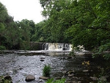
railway line. On entering the town of Paisley, the river falls over rapids called The Hammills, and flows under two roads, to emerge in the town centre at Paisley Abbey
Paisley Abbey
Paisley Abbey is a former Cluniac monastery, and current Church of Scotland parish kirk, located on the east bank of the White Cart Water in the centre of the town of Paisley, Renfrewshire, in west central Scotland.-History:...
. It then passes under Gauze Street, the Piazza Shopping Centre and Paisley Gilmour Street railway station
Paisley Gilmour Street railway station
Paisley Gilmour Street railway station is one of four stations serving the town of Paisley, Renfrewshire, Scotland . The station is managed by First ScotRail and is on the Ayrshire Coast Line, 12 km west of...
where it emerges from the Abercorn Bridge, a wide, high arch
Arch
An arch is a structure that spans a space and supports a load. Arches appeared as early as the 2nd millennium BC in Mesopotamian brick architecture and their systematic use started with the Ancient Romans who were the first to apply the technique to a wide range of structures.-Technical aspects:The...
ed red sandstone
Sandstone
Sandstone is a sedimentary rock composed mainly of sand-sized minerals or rock grains.Most sandstone is composed of quartz and/or feldspar because these are the most common minerals in the Earth's crust. Like sand, sandstone may be any colour, but the most common colours are tan, brown, yellow,...
bridge at Old Sneddon Street. From there it runs, mostly hidden from view, towards Glasgow International Airport and Renfrew.
In the town of Paisley the White Cart is joined by a number of tributary streams including the Lady Burn, the St Mirin Burn, the Sneddon Burn and the Espedair Burn. Just outside the burgh boundary, close to Glasgow Airport, the river meets with the Abbot's Burn.
The Greenock
Greenock
Greenock is a town and administrative centre in the Inverclyde council area in United Kingdom, and a former burgh within the historic county of Renfrewshire, located in the west central Lowlands of Scotland...
Road (A8), between Inchinnan
Inchinnan
Inchinnan is a small village in Renfrewshire, Scotland. The village is located on the main A8 road between Renfrew and Greenock, just southeast of the town of Erskine.-History:...
and Renfrew, passes over the White Cart Water by means of the Swing Bridge. The White Cart Water then joins with the Black Cart Water, just downstream of the bridge, to become the River Cart.
Robert Burns
Robert Burns
Robert Burns was a Scottish poet and a lyricist. He is widely regarded as the national poet of Scotland, and is celebrated worldwide...
' poem The Gallant Weaver mentions the River Cart.
A major flood alleviation scheme is currently under construction by Glasgow City Council to protect vulnerable property on the south side of Glasgow. Designed by Halcrow
Halcrow Group Limited
Halcrow Group Limited is an engineering consultancy company, based in the United Kingdom.Halcrow is one of the UK's leading consultancies, with a pedigree stretching back to 1868. The UK-based consultancy specialises in the provision of planning, design and management services for infrastructure...
the scheme will be the largest flood alleviation project undertaken in Scotland.
Medieval uses
Paisley AbbeyPaisley Abbey
Paisley Abbey is a former Cluniac monastery, and current Church of Scotland parish kirk, located on the east bank of the White Cart Water in the centre of the town of Paisley, Renfrewshire, in west central Scotland.-History:...
has a medieval drain, belonging to the monastery
Monastery
Monastery denotes the building, or complex of buildings, that houses a room reserved for prayer as well as the domestic quarters and workplace of monastics, whether monks or nuns, and whether living in community or alone .Monasteries may vary greatly in size – a small dwelling accommodating only...
, which was rediscovered in the 1990s; and excavated by archaeologists. The abbey/monastery drain linked with the White Cart Water both upstream and downstream of the abbey, near to where the Town Hall now stands. The White Cart Water provided both drinking water for the monastery and was used to flush away kitchen
Kitchen
A kitchen is a room or part of a room used for cooking and food preparation.In the West, a modern residential kitchen is typically equipped with a stove, a sink with hot and cold running water, a refrigerator and kitchen cabinets arranged according to a modular design. Many households have a...
waste and the latrine
Latrine
A latrine is a communal facility containing one or more commonly many toilets which may be simple pit toilets or in the case of the United States Armed Forces any toilet including modern flush toilets...
s.
River Cart Navigation improvement schemes
The River Cart and the White Cart Water are navigable to Paisley; being blocked in the 1960s, at Sneddon Street, by the aqueduct under the Piazza Shopping Centre.18th & 19th century improvements
The Paisley Beer Duties Act 1753 provided for "laying a duty of two pennies Scots, or one sixth part of a penny Sterling, on every Scots Pint of Ale and Beer which shall be brewed for sale, brought into, tapped or sold within the Town of Paisley and Liberties thereof, in the County of Renfrew, for improving the Navigation of the River Cart, and for other Purposes".A further Act of Parliament
Act of Parliament
An Act of Parliament is a statute enacted as primary legislation by a national or sub-national parliament. In the Republic of Ireland the term Act of the Oireachtas is used, and in the United States the term Act of Congress is used.In Commonwealth countries, the term is used both in a narrow...
was obtained by the Cart Trust for the river's improvement in 1787, in response to pressure from Paisley's shipbuilders. This led to some improvements around Inchinnan. The first steamer
Steamboat
A steamboat or steamship, sometimes called a steamer, is a ship in which the primary method of propulsion is steam power, typically driving propellers or paddlewheels...
serviceto Paisley, provided by the Prince of Orange, started in July 1815.
The original Swing Bridge, at Inchinnan, on the Turn Pike
Toll road
A toll road is a privately or publicly built road for which a driver pays a toll for use. Structures for which tolls are charged include toll bridges and toll tunnels. Non-toll roads are financed using other sources of revenue, most typically fuel tax or general tax funds...
road, now the A8, was opened in 1838; the mechanism for swing bridge was made by Barr and McNab of the Abercorn Foundry, Paisley. A year earlier the, Scotch gauge
Scotch gauge
Scotch gauge was the name given to a track gauge, that was adopted by early 19th century railways mainly in the Lanarkshire area of Scotland. It differed from the gauge of that was used on some early lines in England; and from the standard gauge of...
, Paisley and Renfrew Railway
Paisley and Renfrew Railway
The Paisley and Renfrew railway was a railway line from the town of Paisley to its neighbouring town Renfrew; and to the River Clyde at Renfrew wharf. The railway was built to the Scotch gauge of...
had opened between Paisley Hamilton Street
Paisley Hamilton Street railway station
Paisley railway station was an early railway station in Paisley, Renfrewshire, Scotland. It was built in 1837 by the Paisley and Renfrew Railway; and, together with the station at Renfrew Wharf, was one of two terminal stations on the line...
and Renfrew Wharf. The railway was intended to both enhance the capabilities of the River Cart navigation as well as competing against it for goods and passenger traffic. The Cart Trust later went bankrupt.
The Forth and Cart Canal
Forth and Cart Canal
The Forth and Cart Canal was a short 0.5-mile link canal which provided a short cut between the Forth and Clyde Canal, at Whitecrook, and the River Clyde, opposite the mouth of the River Cart. It was intended to provide a transport link between the town of Paisley, the Firth of Forth and Port...
, opened in 1840, together with the Forth and Clyde Canal
Forth and Clyde Canal
The Forth and Clyde Canal crosses Scotland, providing a route for sea-going vessels between the Firth of Forth and the Firth of Clyde at the narrowest part of the Scottish Lowlands. The canal is 35 miles long and its eastern end is connected to the River Forth by a short stretch of the River...
, was intended to provide a direct link between Paisley, Port Dundas
Port Dundas
Port Dundas is an area of Glasgow, Scotland, located to the north of the city centre. It lies to the north of Cowcaddens, and to the west of Sighthill, with Hamiltonhill and Possilpark to the north-west.-History:...
, Edinburgh
Edinburgh
Edinburgh is the capital city of Scotland, the second largest city in Scotland, and the eighth most populous in the United Kingdom. The City of Edinburgh Council governs one of Scotland's 32 local government council areas. The council area includes urban Edinburgh and a rural area...
, and the Firth of Forth
Firth of Forth
The Firth of Forth is the estuary or firth of Scotland's River Forth, where it flows into the North Sea, between Fife to the north, and West Lothian, the City of Edinburgh and East Lothian to the south...
, without the need to go down the River Clyde to Bowling
Bowling, Scotland
Bowling is a village in West Dunbartonshire, Scotland. It lies on the north bank of the Firth of Clyde, between the towns of Clydebank and Dumbarton. It is at one end of the Antonine Wall and therefore represents the extreme limit of the Roman Empire on the west coast of the island of Great Britain...
and return along the Forth and Clyde Canal to almost the starting point. Its aim was to bring coal
Coal
Coal is a combustible black or brownish-black sedimentary rock usually occurring in rock strata in layers or veins called coal beds or coal seams. The harder forms, such as anthracite coal, can be regarded as metamorphic rock because of later exposure to elevated temperature and pressure...
to Paisley.
In January 1866 the Paisley and Renfrew Railway was temporarily closed. When it reopened as a Standard gauge
Standard gauge
The standard gauge is a widely-used track gauge . Approximately 60% of the world's existing railway lines are built to this gauge...
railway it was linked to the Glasgow and Paisley Joint Railway
Glasgow and Paisley Joint Railway
The Glasgow and Paisley Joint Railway company was formed in 1837 to provide a railway link between Glasgow and Paisley, Scotland. It was promoted jointly by the Glasgow, Paisley and Greenock Railway and the Glasgow, Paisley, Kilmarnock and Ayr Railway....
at Arkleston Junction
Arkleston Junction
Arkleston Junction is a railway junction east of the town of Paisley, Renfrewshire, Scotland. The junction is one mile from Paisley Gilmour Street railway station and is heavily used by both passenger and freight traffic.-Post 1967-electrification:...
. As a result Hamilton Street station closed.
Paisley's harbour was extended and the re-opening in April 1891 was celebrated by a fleet of steamers sailing from Paisley to Rothesay
Rothesay, Argyll and Bute
The town of Rothesay is the principal town on the Isle of Bute, in the council area of Argyll and Bute, Scotland. It can be reached by ferry from Wemyss Bay which offers an onward rail link to Glasgow. At the centre of the town is Rothesay Castle, a ruined castle which dates back to the 13th...
.
20th century improvements
Further, unsuccessful, attempts were made to improve the River Cart at the start of the 20th century. In 1920, after the end of World War IWorld War I
World War I , which was predominantly called the World War or the Great War from its occurrence until 1939, and the First World War or World War I thereafter, was a major war centred in Europe that began on 28 July 1914 and lasted until 11 November 1918...
, attempts were made to buy out the bankrupt Cart Trust; but they resisted these attempts.
The swing bridge at Inchinnan was replaced by the present bridge in 1923; it was made by Sir William Arrol & Co.
Sir William Arrol & Co.
Sir William Arrol & Co. was a leading Scottish civil engineering business founded by William Arrol and based in Glasgow. It built some of the most famous bridges in the United Kingdom including the Forth Bridge and Tower Bridge in London.-Early history:...
It lifts vertically so it is more of a Bascule bridge
Bascule bridge
A bascule bridge is a moveable bridge with a counterweight that continuously balances the span, or "leaf," throughout the entire upward swing in providing clearance for boat traffic....
than a Swing bridge, but it is still known as the swing bridge. It is still capable of opening, as the Babcock and Wilcox
Babcock and Wilcox
The Babcock & Wilcox Company is a U.S.-based company that provides design, engineering, manufacturing, construction and facilities management services to nuclear, renewable, fossil power, industrial and government customers worldwide. B&W's boilers supply more than 300,000 megawatts of installed...
(now Doosan Babcock
Doosan Babcock
Doosan Babcock, is part of Doosan Power Systems Ltd a UK-based subsidiary of Doosan Heavy Industries & Construction. DPS is a power sector utility boiler OEM and after market services company, offering specialist services and technologies to clients in the nuclear power generation, fossil-fired...
) factory at Renfrew requires the capability to move large loads by river.
Sir William Arrol and Co also made the pedestrian
Pedestrian
A pedestrian is a person traveling on foot, whether walking or running. In some communities, those traveling using roller skates or skateboards are also considered to be pedestrians. In modern times, the term mostly refers to someone walking on a road or footpath, but this was not the case...
lifting bridge across the White Cart Water at Carlile Quay (off New Sneddon Street) but this has been disabled from lifting for over 30 years and has been closed to traffic since 1997, the structure being deemed unsafe.
An Act of Parliament was obtained in 1938 by the Ministry of Transport
Department for Transport
In the United Kingdom, the Department for Transport is the government department responsible for the English transport network and a limited number of transport matters in Scotland, Wales and Northern Ireland which are not devolved...
, the Admiralty
Admiralty
The Admiralty was formerly the authority in the Kingdom of England, and later in the United Kingdom, responsible for the command of the Royal Navy...
and the Ministry of Shipping. A harbour was built at Laigh Park (Laighpark harbour) at which large cargo boats / ship
Ship
Since the end of the age of sail a ship has been any large buoyant marine vessel. Ships are generally distinguished from boats based on size and cargo or passenger capacity. Ships are used on lakes, seas, and rivers for a variety of activities, such as the transport of people or goods, fishing,...
s could load and unload; it was linked to the Paisley and Renfrew Railway. This was used extensively during World War II
World War II
World War II, or the Second World War , was a global conflict lasting from 1939 to 1945, involving most of the world's nations—including all of the great powers—eventually forming two opposing military alliances: the Allies and the Axis...
. Carlile Quay being used for smaller boats. The navigation lights were also upgraded.
The harbour fell into disuse in the 1960s and has been used as a scrapyard for many decades. Carlile Quay has been landscaped, refurbished and made more attractive to pedestrians. Apartment buildings and houses have been built on the vacant site adjacent to the quay.
Sewage
All of Paisley's sewageSewage
Sewage is water-carried waste, in solution or suspension, that is intended to be removed from a community. Also known as wastewater, it is more than 99% water and is characterized by volume or rate of flow, physical condition, chemical constituents and the bacteriological organisms that it contains...
and industrial effluent
Effluent
Effluent is an outflowing of water or gas from a natural body of water, or from a human-made structure.Effluent is defined by the United States Environmental Protection Agency as “wastewater - treated or untreated - that flows out of a treatment plant, sewer, or industrial outfall. Generally refers...
had been discharged untreated into the River Cart via its tributaries: the St Mirin Burn, the Lady Burn, the Sneddon Burn, the Espedair Burn, etc. By 1870 this had led to many complaints about smells and epidemic
Epidemic
In epidemiology, an epidemic , occurs when new cases of a certain disease, in a given human population, and during a given period, substantially exceed what is expected based on recent experience...
s.
"Intercepting sewers" were therefore built on either side of the St Mirin burn to intercept the sewage and discharge it directly into the White Cart Water. Whilst this helped clean up Paisley it did not clean up the River Cart. It led to complaints from Johnstone
Johnstone
Johnstone is a town in the council area of Renfrewshire and larger historic county of the same name in the west central Lowlands of Scotland.The town lies three miles west of neighbouring Paisley and twelve miles west of the centre of the city of Glasgow...
, Renfrew
Renfrew
-Local government:The town of Renfrew gave its name to a number of local government areas used at various times:*Renfrew a town to the west of Glasgow*Renfrewshire, the present unitary local council area in which Renfrew is situatated....
and Glasgow
Glasgow
Glasgow is the largest city in Scotland and third most populous in the United Kingdom. The city is situated on the River Clyde in the country's west central lowlands...
and calls by them for Paisley to provide a sewage treatment farm. Johnstone, Bridge of Weir
Bridge of Weir
Bridge of Weir is a village in within the Renfrewshire council area and wider historic county of Renfrewshire in the west central Lowlands of Scotland...
, Lochwinnoch
Lochwinnoch
Lochwinnoch is a village in the council area and historic county of Renfrewshire in the west central Lowlands of Scotland. Lying on the banks of Castle Semple Loch and the River Calder, Lochwinnoch is chiefly a residential dormitory village serving nearby urban centres such as Glasgow and Paisley...
and Glasgow already had sewage treatment farms. Glasgow's works had begun operations in 1894.
Land at Laigh Park was bought for this purpose between the first and second World Wars although construction work did not start until 1949 with the works opening in 1952. The sewage works were linked to the intercepting sewers and took all of Paisley's sewage and industrial effluent for treatment.
Water power
Both the Black Cart Water and the White Cart Water provided power to drive mills. The best preserved on the White Cart is Dripps Mill in Waterfoot, which still has two functioning 19th century waterwheels.See also
- Canals of the United KingdomCanals of the United KingdomThe canals of the United Kingdom are a major part of the network of inland waterways in the United Kingdom. They have a colourful history, from use for irrigation and transport, through becoming the focus of the Industrial Revolution, to today's role for recreational boating...
- History of the British canal systemHistory of the British canal systemThe British canal system of water transport played a vital role in the United Kingdom's Industrial Revolution at a time when roads were only just emerging from the medieval mud and long trains of pack horses were the only means of "mass" transit by road of raw materials and finished products The...
External links
- White Cart Walkway – Section of walk from Cathcart to Netherlee.
- Levern, Cart and Brock Burn – South Glasgow Rivers.