
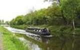
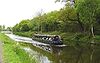
Forth and Clyde Canal
Encyclopedia
Firth of Forth
The Firth of Forth is the estuary or firth of Scotland's River Forth, where it flows into the North Sea, between Fife to the north, and West Lothian, the City of Edinburgh and East Lothian to the south...
and the Firth of Clyde
Firth of Clyde
The Firth of Clyde forms a large area of coastal water, sheltered from the Atlantic Ocean by the Kintyre peninsula which encloses the outer firth in Argyll and Ayrshire, Scotland. The Kilbrannan Sound is a large arm of the Firth of Clyde, separating the Kintyre Peninsula from the Isle of Arran.At...
at the narrowest part of the Scottish Lowlands
Scottish Lowlands
The Scottish Lowlands is a name given to the Southern half of Scotland.The area is called a' Ghalldachd in Scottish Gaelic, and the Lawlands ....
. The canal
Canal
Canals are man-made channels for water. There are two types of canal:#Waterways: navigable transportation canals used for carrying ships and boats shipping goods and conveying people, further subdivided into two kinds:...
is 35 miles (56 km) long and its eastern end is connected to the River Forth
River Forth
The River Forth , long, is the major river draining the eastern part of the central belt of Scotland.The Forth rises in Loch Ard in the Trossachs, a mountainous area some west of Stirling...
by a short stretch of the River Carron
River Carron (Forth)
The River Carron is a river in central Scotland. This river has given its name to towns in Falkirk, a variety of regional features, a type of cannon, a line of bathtubs, two warships and an island in the Southern Hemisphere.-River Carron:The river rises in the Campsie Fells before flowing into...
near Grangemouth
Grangemouth
Grangemouth is a town and former burgh in the council area of Falkirk, Scotland. The town lies in the Forth Valley, on the banks of the Firth of Forth, east of Falkirk, west of Bo'ness and south-east of Stirling. Grangemouth had a resident population of 17,906 according to the 2001...
. The highest section of the canal passes close to Kilsyth
Kilsyth
Kilsyth is a town of 10,100 roughly halfway between Glasgow and Stirling in North Lanarkshire, Scotland.-Location:...
and is fed by an aqueduct
Aqueduct
An aqueduct is a water supply or navigable channel constructed to convey water. In modern engineering, the term is used for any system of pipes, ditches, canals, tunnels, and other structures used for this purpose....
which gathers water from (the purpose built) Birkenburn Reservoir in the Kilsyth Hills, stored in another purpose-built reservoir
Reservoir
A reservoir , artificial lake or dam is used to store water.Reservoirs may be created in river valleys by the construction of a dam or may be built by excavation in the ground or by conventional construction techniques such as brickwork or cast concrete.The term reservoir may also be used to...
called Townhead near Banton, from where it feeds the canal via a feeder from the Shawend Burn near Craigmarloch. The canal continues past Twechar
Twechar
Twechar is a small former mining village in East Dunbartonshire, Scotland. It lies between the larger towns of Kirkintilloch and Kilsyth.The Forth and Clyde Canal runs close to the village to the north, and closely follows the line of the Antonine Wall...
, through Kirkintilloch
Kirkintilloch
Kirkintilloch is a town and former burgh in East Dunbartonshire, Scotland. It lies on the Forth and Clyde Canal, about eight miles northeast of central Glasgow...
and Bishopbriggs
Bishopbriggs
Bishopbriggs is a town in East Dunbartonshire, Scotland. The area was once part of the historic parish of Cadder - originally lands granted by King William the Lion to the Bishop of Glasgow, Jocelin, in 1180. It was later part of the county of Lanarkshire and subsequently an independent burgh from...
to the Maryhill
Maryhill
Maryhill is an area of the City of Glasgow in Scotland. Maryhill is a former burgh. The population of Maryhill is about 52,000. Maryhill stretches over along Maryhill Road...
area north of Glasgow
Glasgow
Glasgow is the largest city in Scotland and third most populous in the United Kingdom. The city is situated on the River Clyde in the country's west central lowlands...
city centre. A branch to Port Dundas
Port Dundas
Port Dundas is an area of Glasgow, Scotland, located to the north of the city centre. It lies to the north of Cowcaddens, and to the west of Sighthill, with Hamiltonhill and Possilpark to the north-west.-History:...
was built to secure the agreement and financial support of Glasgow merchants who feared losing business if the canal bypassed them completely. The western end of the canal connects to the River Clyde
River Clyde
The River Clyde is a major river in Scotland. It is the ninth longest river in the United Kingdom, and the third longest in Scotland. Flowing through the major city of Glasgow, it was an important river for shipbuilding and trade in the British Empire....
at Bowling
Bowling, Scotland
Bowling is a village in West Dunbartonshire, Scotland. It lies on the north bank of the Firth of Clyde, between the towns of Clydebank and Dumbarton. It is at one end of the Antonine Wall and therefore represents the extreme limit of the Roman Empire on the west coast of the island of Great Britain...
.
In 1840, a short 0.5 mile (0.8 km) canal, the Forth and Cart Canal
Forth and Cart Canal
The Forth and Cart Canal was a short 0.5-mile link canal which provided a short cut between the Forth and Clyde Canal, at Whitecrook, and the River Clyde, opposite the mouth of the River Cart. It was intended to provide a transport link between the town of Paisley, the Firth of Forth and Port...
was built to link the Forth and Clyde canal, at Whitecrook
Whitecrook
Whitecrook is an area in the southeast of the town of Clydebank, West Dunbartonshire, Greater Glasgow, Scotland, UK. It occupies the area between the Forth and Clyde Canal to the north, and Glasgow Road to the southwest....
, to the River Clyde
River Clyde
The River Clyde is a major river in Scotland. It is the ninth longest river in the United Kingdom, and the third longest in Scotland. Flowing through the major city of Glasgow, it was an important river for shipbuilding and trade in the British Empire....
, opposite the mouth of the River Cart
River Cart
The River Cart is a tributary of the River Clyde, Scotland, which it joins from the west roughly midway between the towns of Erskine and Renfrew....
.
Construction
It was designed by John SmeatonJohn Smeaton
John Smeaton, FRS, was an English civil engineer responsible for the design of bridges, canals, harbours and lighthouses. He was also a capable mechanical engineer and an eminent physicist...
. Construction started in 1768 and after delays due to funding problems was completed in 1790. The geologist
Geologist
A geologist is a scientist who studies the solid and liquid matter that constitutes the Earth as well as the processes and history that has shaped it. Geologists usually engage in studying geology. Geologists, studying more of an applied science than a theoretical one, must approach Geology using...
James Hutton
James Hutton
James Hutton was a Scottish physician, geologist, naturalist, chemical manufacturer and experimental agriculturalist. He is considered the father of modern geology...
became very involved in the canal between 1767 and 1774; he contributed his geological knowledge, made extended site inspections, and acted both as a shareholder and as a member of the management committee. The Union Canal
Union Canal (Scotland)
The Union Canal is a 31.5-mile canal in Scotland, from Lochrin Basin, Fountainbridge, Edinburgh to Falkirk, where it meets the Forth and Clyde Canal.-Location and features:...
was then constructed to link the eastern end of the canal to Edinburgh
Edinburgh
Edinburgh is the capital city of Scotland, the second largest city in Scotland, and the eighth most populous in the United Kingdom. The City of Edinburgh Council governs one of Scotland's 32 local government council areas. The council area includes urban Edinburgh and a rural area...
. Between 1789 and 1803 the canal was used for trials of William Symington
William Symington
William Symington was a Scottish engineer and inventor, and the builder of the first practical steamboat, the Charlotte Dundas.-Early life:...
's steamboat
Steamboat
A steamboat or steamship, sometimes called a steamer, is a ship in which the primary method of propulsion is steam power, typically driving propellers or paddlewheels...
s, culminating in the Charlotte Dundas
Charlotte Dundas
The Charlotte Dundas is regarded as the world's "first practical steamboat", the first towing steamboat and the boat that demonstrated the practicality of steam power for ships....
, the "first practical steamboat". The canal subsequently became a major route for Clyde puffer
Clyde puffer
The Clyde puffer is essentially a type of small steamboat which provided a vital supply link around the west coast and Hebrides islands of Scotland, stumpy little cargo ships that have achieved almost mythical status thanks largely to the short stories Neil Munro wrote about the Vital Spark and her...
s, many of which were constructed at Bowling.
In 1842 an Act of Parliament
Act of Parliament
An Act of Parliament is a statute enacted as primary legislation by a national or sub-national parliament. In the Republic of Ireland the term Act of the Oireachtas is used, and in the United States the term Act of Congress is used.In Commonwealth countries, the term is used both in a narrow...
was obtained authorising the Caledonian Railway
Caledonian Railway
The Caledonian Railway was a major Scottish railway company. It was formed in the early 19th century and it was absorbed almost a century later into the London, Midland and Scottish Railway, in the 1923 railway grouping, by means of the Railways Act 1921...
to take over the Forth and Clyde Canal along with the Forth and Cart Canal
Forth and Cart Canal
The Forth and Cart Canal was a short 0.5-mile link canal which provided a short cut between the Forth and Clyde Canal, at Whitecrook, and the River Clyde, opposite the mouth of the River Cart. It was intended to provide a transport link between the town of Paisley, the Firth of Forth and Port...
; although this did not take effect until 1853.
The canal was nationalised
Nationalization
Nationalisation, also spelled nationalization, is the process of taking an industry or assets into government ownership by a national government or state. Nationalization usually refers to private assets, but may also mean assets owned by lower levels of government, such as municipalities, being...
in 1948, along with the railway companies, and control passed to the British Transport Commission
British Transport Commission
The British Transport Commission was created by Clement Attlee's post-war Labour government as a part of its nationalisation programme, to oversee railways, canals and road freight transport in Great Britain...
. In 1962, the British Transport Commission was wound up, and control passed to the British Waterways Board.
Run down and revival
In 1963 the canal was closed rather than construct a motorway crossing, and so it became disused and semi-derelict. Canal locks in the FalkirkFalkirk
Falkirk is a town in the Central Lowlands of Scotland. It lies in the Forth Valley, almost midway between the two most populous cities of Scotland; north-west of Edinburgh and north-east of Glasgow....
area on the Union Canal
Union Canal (Scotland)
The Union Canal is a 31.5-mile canal in Scotland, from Lochrin Basin, Fountainbridge, Edinburgh to Falkirk, where it meets the Forth and Clyde Canal.-Location and features:...
near the connection to the Forth and Clyde canal had been filled in and built over in the 1930s.
As part of the Millennium
Millennium
A millennium is a period of time equal to one thousand years —from the Latin phrase , thousand, and , year—often but not necessarily related numerically to a particular dating system....
celebrations in 2000, National Lottery
National Lottery (United Kingdom)
The National Lottery is the state-franchised national lottery in the United Kingdom and the Isle of Man.It is operated by Camelot Group, to whom the licence was granted in 1994, 2001 and again in 2007. The lottery is regulated by the National Lottery Commission, and was established by the then...
funds were used to regenerate both canals. A boatlifting device, the Falkirk Wheel
Falkirk Wheel
The Falkirk Wheel is a rotating boat lift located in Scotland, UK,connecting the Forth and Clyde Canal with the Union Canal, opened in 2002. It is named after the nearby town of Falkirk which is in central Scotland...
, was built to connect the two canals and once more allow boats to travel from the Clyde or Glasgow to Edinburgh, with a new canal connection to the River Carron and hence the River Forth. The Falkirk Wheel opened on 27 May 2002 and is now a tourist attraction.
The Port Dundas branch has been re-connected to Pinkston Basin, which once formed the terminus of the Monkland Canal
Monkland Canal
The Monkland Canal was a 12.25-mile canal which connected the coal mining areas of Monklands to Glasgow in Scotland. It was opened in 1794, and included a steam-powered inclined plane at Blackhill. It was abandoned for navigation in 1942, but its culverted remains still supply water to the Forth...
, by the construction of 330 yards (301.8 m) of new canal and two locks. The project cost £5.6 million, and the first lock and intermediate basin were opened on 29 September 2006. Opening of the second lock was delayed by a dispute over land ownership.
Locks
There are 39 locks on the Forth & Clyde Canal, as follows:- 1 - ?
- 2 - Basin Moorings (Sea Lock)
- 3 - Carron Cut Lock
- 4 - Abbotshaugh Lock
- 5 - Bainsford Lock
- 6 - Grahamston Iron Works Lock
- 7 - Merchiston Lock
- 8 - Merers Lock
- 9 - Camelon Railway Lock
- 10 - CamelonCamelonCamelon is a large settlement within the Falkirk council area, Scotland. The village is in the Forth Valley, west of Falkirk, south of Larbert and east of Bonnybridge...
Lock - 11 - Rosebank Lock
- 12 - Camelon Lock No. 12
- 13 - Camelon Lock No. 13
- 14 - Camelon Lock No. 14
- 15 - Falkirk WheelFalkirk WheelThe Falkirk Wheel is a rotating boat lift located in Scotland, UK,connecting the Forth and Clyde Canal with the Union Canal, opened in 2002. It is named after the nearby town of Falkirk which is in central Scotland...
- 16 - Falkirk Bottom Lock No. 16
- 17 - Underwood Lock No. 17
- 18 - Allendale Lock No. 18
- 19 - Castlecary Lock No. 19
- 20 - Wyndford Lock No. 20 (SUMMIT LEVEL)
- 21 - MaryhillMaryhillMaryhill is an area of the City of Glasgow in Scotland. Maryhill is a former burgh. The population of Maryhill is about 52,000. Maryhill stretches over along Maryhill Road...
Top Lock No. 21 (SUMMIT LEVEL) - 22 - Maryhill Lock
- 23 - Maryhill Lock
- 24 - Maryhill Lock
- 25 - Maryhill Bottom Lock No. 25
- 26 - Kelvindale (Temple Lock No. 26)
- 27 - Temple Lock No. 27
- 28 - Cloberhill Top Lock No. 28
- 29 - Cloberhill Middle Lock No. 29
- 30 - Cloberhill Bottom Lock No. 30
- 31 - Cloberhill Lock No. 31
- 32 - Cloberhill Lock No. 32
- 33 - Boghouse Top Lock No. 33
- 34 - Boghouse Middle Lock No. 34
- 35 - Boghouse Lower Lock. 35
- 36 - No. 36
- Drop Lock - Dalmuir Drop Lock (constructed recently to take navigation below bridge)
- 37 - Old KilpatrickOld KilpatrickOld Kilpatrick is a village in West Dunbartonshire, Scotland.The village is on the north bank of the River Clyde immediately to the north of the Forth and Clyde Canal, three miles from Clydebank on the road to Dumbarton. The Great Western Road runs through Old Kilpatrick, and the next village to...
- 38 - Dalnottar Lock No. 37
- 39 - Bowling Lock No. 38
The overall ruling dimensions are length: 68 in 7 in (20.9 m); beam: 19 in 9 in (6.02 m); draught: 6 in 0 in (1.83 m); headroom: 9 in 1 in (2.77 m), but at the western end larger vessels may use the Bowling basin.
- Data sourced from www.waterscape.com
See also
- AuchinstarryAuchinstarryAuchinstarry is a village in North Lanarkshire, Scotland, UK, near to Kilsyth, Dullatur and Queenzieburn. It is the site of a Roman fort.Auchinstarry Basin is on the Forth and Clyde Canal, and a £1.2m regeneration project has created a mooring basin for boats with 56 pontoon berths, a hard standing...
and its new basin, a £1.2m regenerationUrban renewalUrban renewal is a program of land redevelopment in areas of moderate to high density urban land use. Renewal has had both successes and failures. Its modern incarnation began in the late 19th century in developed nations and experienced an intense phase in the late 1940s – under the rubric of...
project - Forth to Firth Canal PathwayForth to Firth Canal PathwayThe Firth to Forth canal pathway runs from the Firth of Clyde to Firth of Forth and is a long footpath and cycleway that runs across Scotland, between Bowling, west of Glasgow, and Lochrin Basin in Edinburgh. The path runs on the towpaths of the Forth & Clyde and Union Canals and is entirely off...
- Forth and Cart CanalForth and Cart CanalThe Forth and Cart Canal was a short 0.5-mile link canal which provided a short cut between the Forth and Clyde Canal, at Whitecrook, and the River Clyde, opposite the mouth of the River Cart. It was intended to provide a transport link between the town of Paisley, the Firth of Forth and Port...
- Falkirk HelixFalkirk Helix-Project Overview:The Helix project will transform under-used land between Falkirk and Grangemouth into a thriving urban greenspace covering some 300 hectares....
- World Canals ConferenceWorld Canals ConferenceThe World Canals Conference is an annual conference about canals and other waterways worldwide. The first conference took place in 1988, and the 2008 conference will be the twenty-first...
External links
- Environmental Advisory Service case study on Auchinstarry Basin
- The Forth & Clyde and Union Canals
- The Scotland Guide: Glasgow, The Forth and Clyde Canal - surveying the canal
- Falkirk Wheel
- The Falkirk Wheel - The Forth and Clyde Canal
- History of the Forth and Clyde Canal - Clyde Waterfront Heritage
- National Library of Scotland: SCOTTISH SCREEN ARCHIVE (archive films about the Forth and Clyde Canal)