

River Gryfe
Encyclopedia
The River Gryfe or River Gryffe is a river
and tributary of the Black Cart Water
, running through the historic county
of Renfrewshire
and the modern council area
s of Renfrewshire
and Inverclyde
in the west central Lowlands
of Scotland
, United Kingdom
.
It gives its name to the surrounding area of Gryffe Valley, also known as the former lordship of Strathgryfe
.
 The river emerges to the south west of the village of Kilmacolm
on the edge of the Duchal Woods. It is fed from a number of streams or burns on the moors
above the village including the Burnbank Water, Blacketty Water and the Mill Burn. Its main tributary is the Gryffe Water (or Gryfe Water) which flows through the village and begins at the Gryffe Reservoir
beside Loch Thom
.
It flows for approximately 16 miles to join the Black Cart
near Glasgow International Airport
beside the M8 motorway; passing through the villages of Bridge of Weir
, Crosslee
and Houston in Renfrewshire
and immediately to the north east of Quarrier's Village
, Inverclyde
.
The Gryfe was formerly used to supply water for powering water mills at Kilmacolm; and at Crosslee
, the latter fed via a lade (millstream) which left the River Gryfe near Bridge of Weir.
The river also supplied process water to ROF Bishopton
; the water was taken near where the Linwood Moss road joins the Houston Road. The Dargavel Burn, which rises north of Kilmacolm, joins the River Gryfe near the site of the former Houston (Georgetown) railway station
after flowing in a south-east direction through ROF Bishopton.
, a predecessor to the Ordnance Survey
maps of Great Britain
. However it seems that 'Gryfe' was the established usage until more recent times.
The 'Gryffe' name is becoming the predominant usage in the area, seen for example in new signposts showing the name of the river and the names of organisations such as the Gryffe Valley Rotary Club and Gryffe High School in Houston, Renfrewshire.
River
A river is a natural watercourse, usually freshwater, flowing towards an ocean, a lake, a sea, or another river. In a few cases, a river simply flows into the ground or dries up completely before reaching another body of water. Small rivers may also be called by several other names, including...
and tributary of the Black Cart Water
River Cart
The River Cart is a tributary of the River Clyde, Scotland, which it joins from the west roughly midway between the towns of Erskine and Renfrew....
, running through the historic county
Counties of Scotland
The counties of Scotland were the principal local government divisions of Scotland until 1975. Scotland's current lieutenancy areas and registration counties are largely based on them. They are often referred to as historic counties....
of Renfrewshire
Renfrewshire (historic)
Renfrewshire or the County of Renfrew is a registration county, the Lieutenancy area of the Lord Lieutenant of Renfrewshire, and one of the counties of Scotland used for local government until 1975. Renfrewshire is located in the West Central Lowlands of Scotland, south of the River Clyde,...
and the modern council area
Council Area
A Council Area is one of the areas defined in Schedule 1 of the Local Government etc. Act 1994 and is under the control of one of the local authorities in Scotland created by that Act.-Legislation :1889...
s of Renfrewshire
Renfrewshire
Renfrewshire is one of 32 council areas used for local government in Scotland. Located in the west central Lowlands, it is one of three council areas contained within the boundaries of the historic county of Renfrewshire, the others being Inverclyde to the west and East Renfrewshire to the east...
and Inverclyde
Inverclyde
Inverclyde is one of 32 council areas used for local government in Scotland. Together with the Renfrewshire and East Renfrewshire council areas, Inverclyde forms part of the historic county of Renfrewshire - which current exists as a registration county and lieutenancy area - located in the west...
in the west central Lowlands
Central Lowlands
The Central Lowlands or Midland Valley is a geologically defined area of relatively low-lying land in southern Scotland. It consists of a rift valley between the Highland Boundary Fault to the north and the Southern Uplands Fault to the south...
of Scotland
Scotland
Scotland is a country that is part of the United Kingdom. Occupying the northern third of the island of Great Britain, it shares a border with England to the south and is bounded by the North Sea to the east, the Atlantic Ocean to the north and west, and the North Channel and Irish Sea to the...
, United Kingdom
United Kingdom
The United Kingdom of Great Britain and Northern IrelandIn the United Kingdom and Dependencies, other languages have been officially recognised as legitimate autochthonous languages under the European Charter for Regional or Minority Languages...
.
It gives its name to the surrounding area of Gryffe Valley, also known as the former lordship of Strathgryfe
Strathgryfe
Strathgryffe or Gryffe Valley is a strath or wide valley centred on the River Gryffe in the west central Lowlands of Scotland....
.
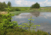
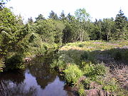
Flow
Kilmacolm
Kilmacolm is a village and civil parish in the Inverclyde council area and the historic county of Renfrewshire in the west central Lowlands of Scotland. It lies on the northern slope of the Gryffe Valley south-east of Greenock and around west of the city of Glasgow...
on the edge of the Duchal Woods. It is fed from a number of streams or burns on the moors
Moorland
Moorland or moor is a type of habitat, in the temperate grasslands, savannas, and shrublands biome, found in upland areas, characterised by low-growing vegetation on acidic soils and heavy fog...
above the village including the Burnbank Water, Blacketty Water and the Mill Burn. Its main tributary is the Gryffe Water (or Gryfe Water) which flows through the village and begins at the Gryffe Reservoir
Gryffe Reservoir
The Gryffe Reservoirs are two reservoirs, known as Gryffe No. 1 and Gryffe No. 2, located in Inverclyde in the west central Lowlands of Scotland....
beside Loch Thom
Loch Thom
Loch Thom is a reservoir which since 1827 has provided a water supply to the town of Greenock in Inverclyde, Scotland. It is named after the civil engineer Robert Thom who designed the scheme which created the reservoir and delivered water via a long aqueduct known as The Cut...
.
It flows for approximately 16 miles to join the Black Cart
River Cart
The River Cart is a tributary of the River Clyde, Scotland, which it joins from the west roughly midway between the towns of Erskine and Renfrew....
near Glasgow International Airport
Glasgow International Airport
Glasgow International Airport is an international airport in Scotland, located west of Glasgow city centre, near the towns of Paisley and Renfrew in Renfrewshire...
beside the M8 motorway; passing through the villages of Bridge of Weir
Bridge of Weir
Bridge of Weir is a village in within the Renfrewshire council area and wider historic county of Renfrewshire in the west central Lowlands of Scotland...
, Crosslee
Crosslee
Crosslee is a small village lying on the bank of the River Gryffe in the parish of Houston and Killellan, Renfrewshire. It lies around half a mile south of the old village centre of Houston and immediately west of Craigends, although residential development has removed any significant open space...
and Houston in Renfrewshire
Renfrewshire
Renfrewshire is one of 32 council areas used for local government in Scotland. Located in the west central Lowlands, it is one of three council areas contained within the boundaries of the historic county of Renfrewshire, the others being Inverclyde to the west and East Renfrewshire to the east...
and immediately to the north east of Quarrier's Village
Quarrier's Village
Quarrier's Village is a small settlement in the civil parish of Kilmacolm in Inverclyde council area and the historic county of Renfrewshire in the west Central Lowlands of Scotland...
, Inverclyde
Inverclyde
Inverclyde is one of 32 council areas used for local government in Scotland. Together with the Renfrewshire and East Renfrewshire council areas, Inverclyde forms part of the historic county of Renfrewshire - which current exists as a registration county and lieutenancy area - located in the west...
.
The Gryfe was formerly used to supply water for powering water mills at Kilmacolm; and at Crosslee
Crosslee
Crosslee is a small village lying on the bank of the River Gryffe in the parish of Houston and Killellan, Renfrewshire. It lies around half a mile south of the old village centre of Houston and immediately west of Craigends, although residential development has removed any significant open space...
, the latter fed via a lade (millstream) which left the River Gryfe near Bridge of Weir.
The river also supplied process water to ROF Bishopton
ROF Bishopton
The Royal Ordnance Factory Bishopton was a UK Ministry of Supply, World War II, Explosive ROF. It is sited adjacent to the town of Bishopton, Renfrewshire, in Scotland....
; the water was taken near where the Linwood Moss road joins the Houston Road. The Dargavel Burn, which rises north of Kilmacolm, joins the River Gryfe near the site of the former Houston (Georgetown) railway station
Georgetown railway station
Georgetown railway station was a railway station serving the village of Houston, Renfrewshire, Scotland, originally as part of the Glasgow, Paisley and Greenock Railway and later owned by the Caledonian Railway.-History:...
after flowing in a south-east direction through ROF Bishopton.
Name
The name 'Gryff' is recorded in the Military Survey of Scotland 1747-1755, compiled by William RoyWilliam Roy
Major-General William Roy FRS was a Scottish military engineer, surveyor, and antiquarian. He was an innovator who applied new scientific discoveries and newly emerging technologies to the accurate geodetic mapping of Great Britain....
, a predecessor to the Ordnance Survey
Ordnance Survey
Ordnance Survey , an executive agency and non-ministerial government department of the Government of the United Kingdom, is the national mapping agency for Great Britain, producing maps of Great Britain , and one of the world's largest producers of maps.The name reflects its creation together with...
maps of Great Britain
Great Britain
Great Britain or Britain is an island situated to the northwest of Continental Europe. It is the ninth largest island in the world, and the largest European island, as well as the largest of the British Isles...
. However it seems that 'Gryfe' was the established usage until more recent times.
The 'Gryffe' name is becoming the predominant usage in the area, seen for example in new signposts showing the name of the river and the names of organisations such as the Gryffe Valley Rotary Club and Gryffe High School in Houston, Renfrewshire.
External links
- River Gryfe at the Gazetteer of Scotland.