
History of the British canal system
Encyclopedia
The British canal
system of water transport played a vital role in the United Kingdom
's Industrial Revolution
at a time when roads were only just emerging from the medieval mud and long trains of pack horses were the only means of "mass" transit by road of raw materials and finished products (it was no accident that amongst the first canal promoters were the pottery manufacturers of Staffordshire
). The UK was the first country to acquire a nationwide canal network.
 The canal system grew rapidly at first, and became an almost completely connected network
covering the South, Midlands
, and parts of the North of England and Wales
. There were canals in Scotland
, but they were not connected to the English canals or, generally, to each other (the main exception being the Monkland Canal
, the Union Canal
and the Forth and Clyde Canal
which connected the River Clyde
and Glasgow
to the River Forth
and Edinburgh
). As building techniques improved, older canals were improved by straightening, embankment
s, cuttings, tunnels, aqueduct
s, inclined plane
s, and boat lift
s, which together snipped many miles and locks
, and therefore, hours and cost, from journeys.
and the Manchester Ship Canal
. By the second half of the 19th century, many canals were increasingly becoming owned by railway companies
or competing with them, and many were in decline, with decreases in mile-ton charges in order to try and remain competitive. After this the less successful canals (particularly narrow-locked canals, whose boats could only carry about thirty ton
s) failed quickly.
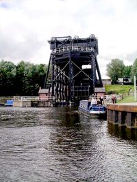
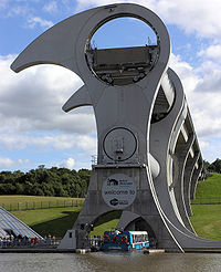 In the 1960s the infant canal leisure industry was only just sufficient to prevent the closure of the still-open canals, but then the pressure to maintain canals for leisure purposes increased. From the 1970s onwards, increasing numbers of closed canals were restored by enthusiast volunteers. The success of these projects has led to the funding and use of contractors to complete large restoration projects and complex civil engineering projects such as the restoration of the Victorian Anderton Boat Lift
and the new Falkirk Wheel
rotating lift.
and the Bedford and Milton Keynes Waterway.
were built in Roman
times as irrigation
canal
s or short connecting spurs between navigable rivers, such as the Foss Dyke
in Lincolnshire. See Roman Britain
.
towpaths for various rivers. These included the rivers Severn
, Witham
, Trent
and Yorkshire Ouse
.
, in 1515, to extend navigation on the River Stour
in Kent
, followed by the River Exe
in 1539, which led to the construction in 1566 of a new channel, the Exeter Canal
. Simple flash lock
s were provided to regulate the flow of water and allow loaded boats to pass through shallow waters by admitting a rush of water, but these were not purpose-built canals as we understand them today.
The transport system that existed before the canals were built consisted of either coastal shipping or horse
s and carts struggling along mostly un-surfaced mud roads (although there were some surfaced Turnpike
roads). There was also a small amount of traffic carried along navigable rivers. In the 17th century, as early industry started to expand, this transport situation was highly unsatisfactory. The restrictions of coastal shipping and river transport were obvious and horses and carts could only carry one or two ton
s of cargo at a time. The poor state of most of the roads meant that they could often become unusable after heavy rain. Because of the small loads that could be carried, supply of essential commodities such as coal
, and iron ore were limited, and this kept prices high and restricted economic growth. One horse-drawn canal barge could carry about thirty tonnes at a time, faster than road transport and at half the cost.
Some 29 river navigation improvements took place in the 16th and 17th centuries. The government of King James established the Oxford-Burcot Commission
in 1605 which began a system of locks and weirs on the River Thames that were opened between Oxford and Abingdon by 1635. In 1635 Sir Richard Weston
was appointed to develop the River Wey Navigation, making Guildford
accessible by 1653. In 1670 the Stamford Canal
opened, indistinguishable from 18th century examples with a dedicated cut and double-door locks. In 1699 legislation was passed to permit the Aire & Calder Navigation which was opened 1703, and the Trent Navigation which was built by George Hayne
and opened in 1712. Subsequently, the Kennet built by John Hore
opened in 1723, the Mersey and Irwell opened in 1725, and the Bristol Avon in 1727. John Smeaton
was the engineer of the Calder & Hebble
which opened in 1758, and a series of eight pound locks was built to replace flash locks on the River Thames between Maidenhead and Reading, beginning in 1772. The net effect of these was to bring most of England, with the notable exceptions of Birmingham and Staffordshire
, within 15 miles (24.1 km) of a waterway.
(which began in Britain during the mid-18th century) demanded an economic and reliable way to transport goods and commodities in large quantities.
By the early 18th century, river navigations such as the Aire and Calder Navigation
were becoming quite sophisticated, with pound locks and longer and longer "cuts" (some with intermediate locks) to avoid circuitous or difficult stretches of river. Eventually, the experience of building long multi-level cuts with their own locks gave rise to the idea of building a "pure" canal, a waterway designed on the basis of where goods needed to go, not where a river happened to be.
The claim for the first pure canal in the United Kingdom is debated between "Sankey" and "Bridgewater" supporters. Others say that neither of these deserve the title, and that other true canals such as the Newry Canal
in Northern Ireland
were constructed by Thomas Steers
before the Industrial Revolution's Canal Mania
.
, which connected St Helens
with the River Mersey
, is often claimed as the first modern "purely artificial" canal because although originally a scheme to make the Sankey Brook navigable, it included an entirely new artificial channel that was effectively a canal along the Sankey Brook valley. However, "Bridgewater" supporters point out that the last quarter-mile of the navigation is indeed a canalised stretch of the Brook, and that it was the Bridgewater Canal (less obviously associated with an existing river) that captured the popular imagination and inspired further canals.
, who owned a number of coal mines in northern England, wanted a reliable way to transport his coal to the rapidly industrialising city of Manchester
. He commissioned the engineer James Brindley
to build a canal to do just that. Brindley's design included an aqueduct
carrying the canal over the River Irwell
. This was an engineering wonder which immediately attracted tourists. The construction of this canal was funded entirely by the Duke and was called the Bridgewater Canal
. It opened in 1761, and was the first major British canal.
alongside the canal for the horse to walk along. This horse-drawn system proved to be highly economical and became standard across the British canal network. Commercial horse-drawn canal boats could be seen on the UK's canals until as late as the 1950s, although by then diesel powered boats, often towing a second unpowered boat, had become standard.
The canal boats could carry thirty tons at a time with only one horse pulling - more than ten times the amount of cargo per horse that was possible with a cart. Because of this huge increase in supply, the Bridgewater canal reduced the price of coal in Manchester by nearly two-thirds within just a year of its opening. The Bridgewater was also a huge financial success, with it earning what had been spent on its construction within just a few years.
saw an opportunity to bring bulky cargoes of clay to his factory doors, and to transport his fragile finished goods to market in Manchester, Birmingham or further afield by water, minimising breakages. Within just a few years of the Bridgewater's opening, an embryonic national canal network came into being, with the construction of canals such as the Oxford Canal
and the Trent & Mersey Canal.
The new canal system was both cause and effect of the rapid industrialisation of the British Midlands and north. The period between the 1770s and the 1830s is often referred to as the "Golden Age" of British canals.
For each canal, an Act of Parliament was necessary to authorise construction, and as people saw the high incomes achieved from canal tolls, canal proposals came to be put forward by investors interested in profiting from dividends, at least as much as by people whose businesses would profit from cheaper transport of raw materials and finished goods.
In a further development, there was often out-and-out speculation, where people would try to buy shares in a newly floated company simply to sell them on for an immediate profit, regardless of whether the canal was ever profitable, or even built. During this period of "canal mania
", huge sums were invested in canal building, and although many schemes came to nothing, the canal system rapidly expanded to nearly 4,000 miles (over 6,400 kilometres) in length, with essentially no external competition.
Many rival canal companies were formed, often competing bitterly. Perhaps the best example of the inefficiencies caused by these rivalries is Worcester Bar
in Birmingham, a point where the Worcester and Birmingham Canal
and the Birmingham Canal Navigations Main Line
were only seven feet apart, with no technical reasons why the canals could not be connected. For many years, a dispute about tolls meant that goods travelling through Birmingham had to be transhipped from boats in one canal to boats in the other.
to serve the families working on the river and the canals. This boat was St Thomas' first chapel of ease
; it was donated by H. Ward, a local coal merchant, and used until it sank in 1868. It was replaced by a chapel dedicated to St Nicholas
, which remained in use until 1892.
Others tried to care for the boat people. Mary Ward (1885–1972) acted as a nurse for decades from the rope shop at Stoke Bruerne
.
in 1776. These locks were 72 feet 7 inches (22.1 m) long by 7 feet 6 inches (2.3 m) wide. The narrow width was perhaps set by the fact that he was only able to build Harecastle Tunnel
to accommodate 7 feet (2.1 m) wide boats.
His next locks were wider. He built locks 72 feet 7 inches (22.1 m) long by 15 feet (4.6 m) wide when he extended the Bridgewater canal to Runcorn
, where the canal's only locks lowered boats to the River Mersey.
The narrow locks on the Trent and Mersey limited the size of the boats (which came to be called narrowboat
s), and thus limited the quantity of the cargo they could carry to around thirty tonnes. This decision would in later years make the canal network economically uncompetitive for freight transport, and by the mid 20th century it was no longer possible to work a thirty tonne load economically.
. The Trent and Mersey Canal was the first part of this ambitious network, but although he and his assistants surveyed the whole potential system, he did not live to see it completed - coal was finally transported from the Midlands to the Thames at Oxford
in January 1790, eighteen years after his death. Development of the network was left to other engineers, such as Thomas Telford
, whose Ellesmere Canal
helped link the Severn and the Mersey.
The bulk of the canal system was built in the industrial Midlands
and the north of England
, where navigable rivers most needed extending and connecting, and heavy cargoes of manufactured goods, raw materials or coal most needed carrying. Most of the traffic on the canal network was internal. However the network linked with coastal port
cities such as London, Liverpool
, and Bristol
, where cargo could be exchanged with sea going ships for import and export.
and West Midlands
regions contain a dense network of canals.
The great manufacturing cities of Manchester and Birmingham
were major economic drivers for the 'canal mania' which reached its peak in 1793, and both benefited from a network of canals, most of which survive.
In the industrial conurbation of Birmingham and the Black Country
, a dense network of nearly one hundred and sixty miles of canals, dubbed the Birmingham Canal Navigations
(BCN) was constructed to serve the network of industries.
A similarly dense network of canals was constructed in the Greater Manchester
area, serving the local textile industries: The Bridgewater
, Rochdale
and Ashton
canals, were examples of these.
Manchester had a canal connection to the nearby port of Liverpool via the Leeds and Liverpool Canal
. However, in the nineteenth century Manchester's merchants became dissatisfied with the poor service and high charges offered by the Liverpool docks, and the near-monopoly of the railways. They decided to bypass the Liverpool monopoly on coastal trade by converting a section of the Irwell
into the Manchester Ship Canal
, which opened in 1894, turning Manchester into an inland port in its own right.
Birmingham's canals linked to the national network in several directions. To the north several trunk cross-country canals, linking Birmingham to Manchester were constructed, including the Trent and Mersey and Shropshire Union Canal
. The Coventry Canal
, the Oxford Canal, and what is now the Grand Union Canal
linked southwards to London. And to the south west, the Worcester & Birmingham and Staffordshire & Worcestershire
canals linked to the River Severn.
towns and cities such as Leeds
, Sheffield
, Bradford
and Huddersfield
develop large textile
and coal mining industries, which required an efficient transport system. As early as the late 17th century, the Aire and Calder
and Calder and Hebble
navigations had been canalised, allowing navigation from Leeds to the Humber Estuary, whereas the River Don Navigation
connected Sheffield to the Humber.
Later in the 18th century, the Leeds and Liverpool Canal
was constructed, creating an east-west link, giving access to the port at Liverpool allowing export of finished goods. The Rochdale
and Huddersfield Broad
and Narrow
canals connected to Manchester.
The East Midlands
cities of Nottingham
and Leicester
were connected to the national network via the canalised River Trent and River Soar
, whilst Leicester had a connection to London via the Grand Union Canal
.
, served by already-navigable rivers like the Thames
and the River Lea, (which was canalised). It needed canals only to take goods in and out from seagoing ships, where such rivers were unavailable.
As early as 1790 London was linked to the national network via the River Thames and the Oxford Canal. A more direct route between London and the national canal network; the Grand Junction Canal
opened in 1805.
Apart from this, relatively few canals were built in London itself; the few that were included the Regent's Canal
and the now defunct Grand Surrey
and Croydon
canals.
To the south of London, the Wey and Arun Canal
linked London to Portsmouth
. However the canal was a financial failure and closed in 1871.
 The South West of England
had several east-west cross-country canals, which connected the River Thames
to the River Severn and the River Avon
, allowing the cities of Bristol
and Bath to be connected to London: These were Thames and Severn Canal
which linked to the Stroudwater Navigation
, the Kennet and Avon Canal
and the Wilts and Berks Canal
, which linked to these three rivers; all of these linked into the national canal system via the Oxford Canal and the River Severn (via the Worcester & Birmingham and Staffordshire & Worcestershire
canals). All of these east-west canals fell derelict in the early 20th century, and only the Kennet and Avon is today navigable, having been restored.
A few self-contained canals, not connected to the national system, were built in Devon
and Cornwall
, such as the Bude Canal
and the St. Columb Canal
. The same was true for South Wales
, with several isolated canals running along the South Wales Valleys
. These included the Swansea Canal
, the Neath and Tennant Canal
, the Glamorganshire Canal
and the Monmouthshire & Brecon Canal
. Nearly all of these canals were constructed to serve local industries, and fell derelict when faced with competition from other modes of transport.
and the Union Canal
connected the major cities in the industrial Central Belt
; they also provide a short cut for boats to cross between the west and the east without a sea voyage. The Caledonian Canal
provided a similar function in the Highlands
of Scotland. The Crinan Canal
avoided the need for a long diversion around the Kintyre
peninsula
, and the Glasgow, Paisley and Johnstone Canal
was intended to link these three places directly to the west coast of Scotland, but never reached beyond Johnstone
. The Monkland Canal
was conceived in 1769 by tobacco merchants and other entrepreneurs as a way of bringing cheap coal into Glasgow from the coalfields of the Monklands area.
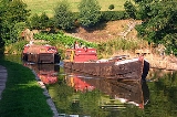
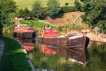
In winter special icebreaker boats with reinforced hulls would be used to break the ice. The boats used on canals were a mixed bunch, but on the narrow canals the 7 feet (2.1 m) wide narrowboat was the standard. On the broad canals they were joined by wider boats which often derived from the type used on connecting rivers. All boats on the canals were horsedrawn and either worked "fly" or "standard". Flyboats carried cargo and sometimes passengers at relatively high speed day and night. These boats were crewed by four men, who operated a watch system whereby two men worked while the other two slept. Horses were changed regularly. Standard working involved travelling largely in daylight hours, with crews swapping boats so as to sleep at home most nights. The boats were owned and operated by individual carriers, or by carrying companies who would pay the helmsman a wage depending on the distance travelled, and the amount of cargo.
Canal companies were unable to compete against the speed of the new railways, and in order to survive they had to slash their prices. This put an end to the huge profits that canal companies had enjoyed before the coming of the railways, and also had an effect on the boatmen who faced a big drop in wages. Flyboat working virtually ceased, as it could not compete with the railways on speed and the boatmen found they could only afford to keep their families by taking them with them on the boats. This became standard practice across the canal system, with in many cases families with several children living in tiny boat cabins, creating a considerable community of boat people. Though this community ostensibly had much in common with Gypsies both communities strongly resisted any such comparison, and surviving boat people feel deeply insulted if described as 'water gypsies'.
By the 1850s the railway system had become well established and the amount of cargo carried on the canals had fallen by nearly two-thirds, lost mostly to railway competition. In many cases struggling canal companies were bought out by railway companies. Sometimes this was a tactical move by railway companies to gain ground in their competitors' territory, but sometimes canal companies were bought out, either to close them down and remove competition or to build a railway on the line of the canal. A notable example of this is the Croydon Canal
. Larger canal companies survived independently and were able to continue to make profits. The canals survived through the 19th century largely by occupying the niches in the transport market that the railways had missed, or by supplying local markets such as the coal-hungry factories and mills of the big cities.
Overall, the canals adapted to the appearance of railways and in 1900 the canal network differed little from its extent in 1830.
s, compared to the thirty to one hundred tonnes that was possible on the much narrower British canals. As it is economic to transport freight by canal only if this is done in bulk, the widening ensured that in many of these countries, canal freight transport is still economically viable.
This canal modernisation never occurred on a large scale in the UK, mainly because of the power of the railway companies who owned most of the canals and saw no reason to invest in a competing, and from their point of view obsolete, form of transport. In view of this attitude, there was little point in the non-railway owned canals modernising, since they controlled only parts of the system. The only significant exception to this was the modernisation carried out on the Grand Union Canal
in the 1930s. Thus almost uniquely in Europe, many of the UK's canals remain as they have been since the 18th and 19th century: mostly operated with narrowboats less than 7 feet (2.3 m) wide and 70 feet (23 m) long (although in parts of the country slightly larger canals were constructed, called 'broad' or 'wide' canals, which could take boats that were 14 feet (4.3 m) wide and 70 feet (21.3 m) long). A major exception to this stagnation was the Manchester Ship Canal, newly built in the 1890s using the existing River Irwell
and River Mersey, to take ocean-going ships into the centre of Manchester via its neighbour Salford.
and Second World Wars and still carried a substantial amount of freight until the early 1950s. The final blow was delivered by technological change.
Most of the canal system and inland waterways were nationalised in 1948, along with the railways, under the British Transport Commission
, whose subsidiary Docks and Inland Waterways Executive managed them into the 1950s. A report in 1955 by the British Transport Commission
placed the canals in the UK into three categories according to their economic prospects; waterways to be developed, waterways to be retained, and waterways having insufficient commercial prospects to justify their retention for navigation. During the 1950s and 1960s freight transport on the canals declined rapidly in the face of mass road transport, and several more canals were abandoned during this period. Most of the traffic on the canals by this time was in coal delivered to waterside factories which had no other convenient access. In the 1950s and 60s these factories either switched to using other fuels, often because of the Clean Air Act
of 1956, or closed completely. The last carrying contract, to a jam factory near London, ended in 1971.
Under the Transport Act of 1962, the canals were transferred in 1963 to the British Waterways Board (BWB), now British Waterways
, and the railways to the British Railways Board
(BRB). In the same year a remarkably harsh winter saw many boats frozen into their moorings, and unable to move for weeks at a time. This was one of the reasons given for the decision by BWB to formally cease their commercial carrying on the canals. By this time the canal network had shrunk to just two thousand miles (3,000 kilometres), half the size it was at its peak in the early 19th century. However, the basic network was still intact; many of the closures were of duplicate routes or branches.
classified the nationalised waterways as:
British Waterways Board was required, under the Act, to keep Commercial Waterways, mainly in the north-east, fit for commercial use; and Cruising Waterways fit for cruising. However, these obligations were subject to the caveat of being by the most economical means. There was no requirement to maintain Remainder waterways or keep them in a navigable condition; they were to be treated in the most economic way possible, which could mean abandonment. British Waterways could also change the classification of an existing waterway. Parts, or all, of a Remainder Waterway canal could also be transferred to local authorities, etc.; and this transfer could, as happened, allow roads and motorways to be built over them, mitigating the need to provide (expensive) accommodation bridges or aqueducts. The act also allowed local authorities to contribute to the upkeep of Remainder Waterways.
by L. T. C. Rolt
and Robert Aickman
has helped revive interest in the UK's canals to the point where they are a major leisure destination.
Since the formation of the Basingstoke Canal Purchasing Committee in March 1949, waterway restoration
organisations have returned many hundreds of miles of abandoned and remainder canals to use, and work is still ongoing to save many more. Many restoration projects have been led by local canal societies or trusts, who were initially formed to fight the closure of a remainder waterway or to save an abandoned canal from further decay. They now work with local authorities and landowners to develop restoration plans and secure funding. The physical work is sometimes done by contractors, sometimes by volunteers. In 1970 the Waterway Recovery Group
was formed to co-ordinate volunteer efforts on canals and river navigations throughout the United Kingdom.
British Waterways
has come to see the economic and social potential of canalside development, and moved from hostility towards restoration, through neutrality, towards a supportive stance. Whilst British Waterways is now broadly supportive of restoration, its official policy is that it will not take on support of newly restored navigations unless they come with a sufficient dowry to pay for their ongoing upkeep. In effect, this means either reclassifying the Remainder Waterway as a Cruising Waterway or entering into an agreement for another body to maintain the waterway.
There has also been a movement to redevelop canals in inner city areas, such as Birmingham, Manchester, Salford and Sheffield, which have both numerous waterways and urban blight. In these cities, waterways redevelopment provides a focus for successful commercial/residential developments such as Gas Street Basin
in Birmingham, Castlefield
Basin and Salford Quays
in Manchester, Victoria Quays
in Sheffield. However, these developments are sometimes controversial. In 2005 environmentalists complained that housing developments on London's waterways threatened the vitality of the canal system.
Canal
Canals are man-made channels for water. There are two types of canal:#Waterways: navigable transportation canals used for carrying ships and boats shipping goods and conveying people, further subdivided into two kinds:...
system of water transport played a vital role in the United Kingdom
United Kingdom of Great Britain and Ireland
The United Kingdom of Great Britain and Ireland was the formal name of the United Kingdom during the period when what is now the Republic of Ireland formed a part of it....
's Industrial Revolution
Industrial Revolution
The Industrial Revolution was a period from the 18th to the 19th century where major changes in agriculture, manufacturing, mining, transportation, and technology had a profound effect on the social, economic and cultural conditions of the times...
at a time when roads were only just emerging from the medieval mud and long trains of pack horses were the only means of "mass" transit by road of raw materials and finished products (it was no accident that amongst the first canal promoters were the pottery manufacturers of Staffordshire
Staffordshire
Staffordshire is a landlocked county in the West Midlands region of England. For Eurostat purposes, the county is a NUTS 3 region and is one of four counties or unitary districts that comprise the "Shropshire and Staffordshire" NUTS 2 region. Part of the National Forest lies within its borders...
). The UK was the first country to acquire a nationwide canal network.
Overview
Transport network
A transport network, or transportation network in American English, is typically a network of roads, streets, pipes, aqueducts, power lines, or nearly any structure which permits either vehicular movement or flow of some commodity....
covering the South, Midlands
English Midlands
The Midlands, or the English Midlands, is the traditional name for the area comprising central England that broadly corresponds to the early medieval Kingdom of Mercia. It borders Southern England, Northern England, East Anglia and Wales. Its largest city is Birmingham, and it was an important...
, and parts of the North of England and Wales
Wales
Wales is a country that is part of the United Kingdom and the island of Great Britain, bordered by England to its east and the Atlantic Ocean and Irish Sea to its west. It has a population of three million, and a total area of 20,779 km²...
. There were canals in Scotland
Scotland
Scotland is a country that is part of the United Kingdom. Occupying the northern third of the island of Great Britain, it shares a border with England to the south and is bounded by the North Sea to the east, the Atlantic Ocean to the north and west, and the North Channel and Irish Sea to the...
, but they were not connected to the English canals or, generally, to each other (the main exception being the Monkland Canal
Monkland Canal
The Monkland Canal was a 12.25-mile canal which connected the coal mining areas of Monklands to Glasgow in Scotland. It was opened in 1794, and included a steam-powered inclined plane at Blackhill. It was abandoned for navigation in 1942, but its culverted remains still supply water to the Forth...
, the Union Canal
Union Canal (Scotland)
The Union Canal is a 31.5-mile canal in Scotland, from Lochrin Basin, Fountainbridge, Edinburgh to Falkirk, where it meets the Forth and Clyde Canal.-Location and features:...
and the Forth and Clyde Canal
Forth and Clyde Canal
The Forth and Clyde Canal crosses Scotland, providing a route for sea-going vessels between the Firth of Forth and the Firth of Clyde at the narrowest part of the Scottish Lowlands. The canal is 35 miles long and its eastern end is connected to the River Forth by a short stretch of the River...
which connected the River Clyde
River Clyde
The River Clyde is a major river in Scotland. It is the ninth longest river in the United Kingdom, and the third longest in Scotland. Flowing through the major city of Glasgow, it was an important river for shipbuilding and trade in the British Empire....
and Glasgow
Glasgow
Glasgow is the largest city in Scotland and third most populous in the United Kingdom. The city is situated on the River Clyde in the country's west central lowlands...
to the River Forth
River Forth
The River Forth , long, is the major river draining the eastern part of the central belt of Scotland.The Forth rises in Loch Ard in the Trossachs, a mountainous area some west of Stirling...
and Edinburgh
Edinburgh
Edinburgh is the capital city of Scotland, the second largest city in Scotland, and the eighth most populous in the United Kingdom. The City of Edinburgh Council governs one of Scotland's 32 local government council areas. The council area includes urban Edinburgh and a rural area...
). As building techniques improved, older canals were improved by straightening, embankment
Embankment (transportation)
To keep a road or railway line straight or flat, and where the comparative cost or practicality of alternate solutions is prohibitive, the land over which the road or rail line will travel is built up to form an embankment. An embankment is therefore in some sense the opposite of a cutting, and...
s, cuttings, tunnels, aqueduct
Aqueduct
An aqueduct is a water supply or navigable channel constructed to convey water. In modern engineering, the term is used for any system of pipes, ditches, canals, tunnels, and other structures used for this purpose....
s, inclined plane
Canal inclined plane
An inclined plane is a system used on some canals for raising boats between different water levels. Boats may be conveyed afloat, in caissons, or may be carried in cradles or slings. It can be considered as a specialised type of cable railway....
s, and boat lift
Boat lift
A boat lift, ship lift, or lift lock is a machine for transporting boats between water at two different elevations, and is an alternative to the canal lock and the canal inclined plane....
s, which together snipped many miles and locks
Lock (water transport)
A lock is a device for raising and lowering boats between stretches of water of different levels on river and canal waterways. The distinguishing feature of a lock is a fixed chamber in which the water level can be varied; whereas in a caisson lock, a boat lift, or on a canal inclined plane, it is...
, and therefore, hours and cost, from journeys.
18th century
Canals came into being because the Industrial Revolution (which began in Britain during the mid-18th century) demanded an economic and reliable way to transport goods and commodities in large quantities. Some 29 river navigation improvements took place in the 16th and 17th centuries starting with the Thames locks and the River Wey Navigation.19th century
The 19th century saw some major new canals such as the Caledonian CanalCaledonian Canal
The Caledonian Canal is a canal in Scotland that connects the Scottish east coast at Inverness with the west coast at Corpach near Fort William. It was constructed in the early nineteenth century by engineer Thomas Telford, and is a sister canal of the Göta Canal in Sweden, also constructed by...
and the Manchester Ship Canal
Manchester Ship Canal
The Manchester Ship Canal is a river navigation 36 miles long in the North West of England. Starting at the Mersey Estuary near Liverpool, it generally follows the original routes of the rivers Mersey and Irwell through the historic counties of Cheshire and Lancashire. Several sets of locks lift...
. By the second half of the 19th century, many canals were increasingly becoming owned by railway companies
Railway company
A railway company or railroad company is an entity that operates a railroad track and/or trains. Such a company can either be private or public...
or competing with them, and many were in decline, with decreases in mile-ton charges in order to try and remain competitive. After this the less successful canals (particularly narrow-locked canals, whose boats could only carry about thirty ton
Ton
The ton is a unit of measure. It has a long history and has acquired a number of meanings and uses over the years. It is used principally as a unit of weight, and as a unit of volume. It can also be used as a measure of energy, for truck classification, or as a colloquial term.It is derived from...
s) failed quickly.
20th century
The 20th century brought competition from road-haulage, and only the strongest canals survived until the Second World War. After the war decline of trade on all remaining canals was rapid, and by the mid 1960s only a token traffic was left, even on the widest and most industrial waterways.Anderton Boat Lift
The Anderton Boat Lift near the village of Anderton, Cheshire, in north-west England provides a vertical link between two navigable waterways: the River Weaver and the Trent and Mersey Canal....
and the new Falkirk Wheel
Falkirk Wheel
The Falkirk Wheel is a rotating boat lift located in Scotland, UK,connecting the Forth and Clyde Canal with the Union Canal, opened in 2002. It is named after the nearby town of Falkirk which is in central Scotland...
rotating lift.
21st century
Restoration projects by volunteer-led groups continue. There is now a substantial network of interconnecting, fully navigable canals across the country. In places, serious plans are in progress by the Environment Agency and British Waterways Board for building new canals to expand the network, link isolated sections, and create new leisure opportunities for navigating 'canal rings', for example: the Fens Waterways LinkFens Waterways Link
The Fens Waterways Link is a project to improve recreational boating opportunities in the counties of Cambridgeshire and Lincolnshire, England. By a combination of improvements to existing waterways and the construction of new links a circular route between Lincoln, Peterborough, Ely and Boston is...
and the Bedford and Milton Keynes Waterway.
Early history
The first British canalsCanals of the United Kingdom
The canals of the United Kingdom are a major part of the network of inland waterways in the United Kingdom. They have a colourful history, from use for irrigation and transport, through becoming the focus of the Industrial Revolution, to today's role for recreational boating...
were built in Roman
Roman Empire
The Roman Empire was the post-Republican period of the ancient Roman civilization, characterised by an autocratic form of government and large territorial holdings in Europe and around the Mediterranean....
times as irrigation
Irrigation
Irrigation may be defined as the science of artificial application of water to the land or soil. It is used to assist in the growing of agricultural crops, maintenance of landscapes, and revegetation of disturbed soils in dry areas and during periods of inadequate rainfall...
canal
Canal
Canals are man-made channels for water. There are two types of canal:#Waterways: navigable transportation canals used for carrying ships and boats shipping goods and conveying people, further subdivided into two kinds:...
s or short connecting spurs between navigable rivers, such as the Foss Dyke
Foss Dyke
The Foss Dyke, or Fossdyke, connects the River Trent at Torksey to Lincoln, the county town of Lincolnshire, and may be the oldest canal in England that is still in use. It is usually thought to have been built around 120 AD by the Romans, but there is no consensus among authors...
in Lincolnshire. See Roman Britain
Roman Britain
Roman Britain was the part of the island of Great Britain controlled by the Roman Empire from AD 43 until ca. AD 410.The Romans referred to the imperial province as Britannia, which eventually comprised all of the island of Great Britain south of the fluid frontier with Caledonia...
.
Middle Ages
A spate of building projects, such as castles, monasteries and churches, led to the improvement of rivers for the transportation of building materials. Various Acts of Parliament were passed regulating transportation of goods, tolls and horseHorse
The horse is one of two extant subspecies of Equus ferus, or the wild horse. It is a single-hooved mammal belonging to the taxonomic family Equidae. The horse has evolved over the past 45 to 55 million years from a small multi-toed creature into the large, single-toed animal of today...
towpaths for various rivers. These included the rivers Severn
River Severn
The River Severn is the longest river in Great Britain, at about , but the second longest on the British Isles, behind the River Shannon. It rises at an altitude of on Plynlimon, Ceredigion near Llanidloes, Powys, in the Cambrian Mountains of mid Wales...
, Witham
River Witham
The River Witham is a river, almost entirely in the county of Lincolnshire, in the east of England. It rises south of Grantham close to South Witham, at SK8818, passes Lincoln at SK9771 and at Boston, TF3244, flows into The Haven, a tidal arm of The Wash, near RSPB Frampton Marsh...
, Trent
River Trent
The River Trent is one of the major rivers of England. Its source is in Staffordshire on the southern edge of Biddulph Moor. It flows through the Midlands until it joins the River Ouse at Trent Falls to form the Humber Estuary, which empties into the North Sea below Hull and Immingham.The Trent...
and Yorkshire Ouse
River Ouse, Yorkshire
The River Ouse is a river in North Yorkshire, England. The river is formed from the River Ure at Cuddy Shaw Reach near Linton-on-Ouse, about 6 miles downstream of the confluence of the River Swale with the River Ure...
.
Post-medieval transport systems
In the post-medieval period some natural waterways were 'canalised' or improved for boat traffic, in the 16th century. The first Act of Parliament was obtained by the City of CanterburyCanterbury
Canterbury is a historic English cathedral city, which lies at the heart of the City of Canterbury, a district of Kent in South East England. It lies on the River Stour....
, in 1515, to extend navigation on the River Stour
River Stour, Kent
The River Stour is the river in Kent, England that flows into the English Channel at Pegwell Bay. Above Plucks Gutter, where the Little Stour joins it, the river is normally known as the Great Stour. The upper section of the river, above its confluence with the East Stour at Ashford is sometimes...
in Kent
Kent
Kent is a county in southeast England, and is one of the home counties. It borders East Sussex, Surrey and Greater London and has a defined boundary with Essex in the middle of the Thames Estuary. The ceremonial county boundaries of Kent include the shire county of Kent and the unitary borough of...
, followed by the River Exe
River Exe
The River Exe in England rises near the village of Simonsbath, on Exmoor in Somerset, near the Bristol Channel coast, but flows more or less directly due south, so that most of its length lies in Devon. It reaches the sea at a substantial ria, the Exe Estuary, on the south coast of Devon...
in 1539, which led to the construction in 1566 of a new channel, the Exeter Canal
Exeter Canal
The Exeter Ship Canal, sometimes just called the Exeter Canal, downstream of Exeter, Devon, England was built in the 1560s which means it pre-dates the "canal mania" period and is one of the oldest artificial waterways in the UK.-History:...
. Simple flash lock
Flash lock
Early locks were designed with a single gate, known as a flash lock or staunch lock. The earliest European references to what were clearly flash locks were in Roman times....
s were provided to regulate the flow of water and allow loaded boats to pass through shallow waters by admitting a rush of water, but these were not purpose-built canals as we understand them today.
The transport system that existed before the canals were built consisted of either coastal shipping or horse
Horse
The horse is one of two extant subspecies of Equus ferus, or the wild horse. It is a single-hooved mammal belonging to the taxonomic family Equidae. The horse has evolved over the past 45 to 55 million years from a small multi-toed creature into the large, single-toed animal of today...
s and carts struggling along mostly un-surfaced mud roads (although there were some surfaced Turnpike
Turnpike trust
Turnpike trusts in the United Kingdom were bodies set up by individual Acts of Parliament, with powers to collect road tolls for maintaining the principal highways in Britain from the 17th but especially during the 18th and 19th centuries...
roads). There was also a small amount of traffic carried along navigable rivers. In the 17th century, as early industry started to expand, this transport situation was highly unsatisfactory. The restrictions of coastal shipping and river transport were obvious and horses and carts could only carry one or two ton
Ton
The ton is a unit of measure. It has a long history and has acquired a number of meanings and uses over the years. It is used principally as a unit of weight, and as a unit of volume. It can also be used as a measure of energy, for truck classification, or as a colloquial term.It is derived from...
s of cargo at a time. The poor state of most of the roads meant that they could often become unusable after heavy rain. Because of the small loads that could be carried, supply of essential commodities such as coal
Coal
Coal is a combustible black or brownish-black sedimentary rock usually occurring in rock strata in layers or veins called coal beds or coal seams. The harder forms, such as anthracite coal, can be regarded as metamorphic rock because of later exposure to elevated temperature and pressure...
, and iron ore were limited, and this kept prices high and restricted economic growth. One horse-drawn canal barge could carry about thirty tonnes at a time, faster than road transport and at half the cost.
Some 29 river navigation improvements took place in the 16th and 17th centuries. The government of King James established the Oxford-Burcot Commission
Oxford-Burcot Commission
The Oxford-Burcot Commission was the first Commission concerned with the management of the River Thames, appointed by an Act of Parliament of 1605 by James I to make the stretch of river from Burcot to Oxford navigable. The Commission took responsibility for the management of the River Thames...
in 1605 which began a system of locks and weirs on the River Thames that were opened between Oxford and Abingdon by 1635. In 1635 Sir Richard Weston
Richard Weston (1591-1652)
Sir Richard III Weston was an English canal builder and agricultural improver. He instigated the construction of the Wey Navigation one of the first man-made navigations in Britain and introduced new plants and systems of crop rotation....
was appointed to develop the River Wey Navigation, making Guildford
Guildford
Guildford is the county town of Surrey. England, as well as the seat for the borough of Guildford and the administrative headquarters of the South East England region...
accessible by 1653. In 1670 the Stamford Canal
Stamford Canal
-New plans:The river Welland is not currently navigable above Crowland but plans for the Fens Waterways Link include a new link upstream of here to above the Dog in a doublet sluice on the River Nene. There are currently no plans to restore navigation to Stamford....
opened, indistinguishable from 18th century examples with a dedicated cut and double-door locks. In 1699 legislation was passed to permit the Aire & Calder Navigation which was opened 1703, and the Trent Navigation which was built by George Hayne
George Hayne
George Hayne was a merchant and entrepreneur who was responsible for the creation of the Trent Navigation in England and hence the development of Burton upon Trent as the pre-eminent beer brewing and exporting town....
and opened in 1712. Subsequently, the Kennet built by John Hore
John Hore
John Hore was an English navigation engineer notable for engineering the River Kennet navigation in 1718.Born in Newbury, Berkshire to a line of maltsters, worked alongside his father. When his father acquired part-ownership of the River Kennet, he also invested...
opened in 1723, the Mersey and Irwell opened in 1725, and the Bristol Avon in 1727. John Smeaton
John Smeaton
John Smeaton, FRS, was an English civil engineer responsible for the design of bridges, canals, harbours and lighthouses. He was also a capable mechanical engineer and an eminent physicist...
was the engineer of the Calder & Hebble
Calder and Hebble Navigation
The Calder and Hebble Navigation is a Broad inland waterway in West Yorkshire, England, which has remained navigable since it was opened.-History:...
which opened in 1758, and a series of eight pound locks was built to replace flash locks on the River Thames between Maidenhead and Reading, beginning in 1772. The net effect of these was to bring most of England, with the notable exceptions of Birmingham and Staffordshire
History of Staffordshire
The historic county of Staffordshire included Wolverhampton, Walsall, and West Bromwich, these three being removed in 1974 to the new county of West Midlands. The resulting administrative area of Staffordshire has a narrow southwards protrusion that runs west of West Midlands to the border of...
, within 15 miles (24.1 km) of a waterway.
The Industrial Revolution
The modern canal system was mainly a product of the 18th century and early 19th century. It came into being because the Industrial RevolutionIndustrial Revolution
The Industrial Revolution was a period from the 18th to the 19th century where major changes in agriculture, manufacturing, mining, transportation, and technology had a profound effect on the social, economic and cultural conditions of the times...
(which began in Britain during the mid-18th century) demanded an economic and reliable way to transport goods and commodities in large quantities.
By the early 18th century, river navigations such as the Aire and Calder Navigation
Aire and Calder Navigation
The Aire and Calder Navigation is a river and canal system of the River Aire and the River Calder in the metropolitan county of West Yorkshire, England. The first improvements to the rivers above Knottingley were completed in 1704 when the Aire was made navigable to Leeds and the Calder to...
were becoming quite sophisticated, with pound locks and longer and longer "cuts" (some with intermediate locks) to avoid circuitous or difficult stretches of river. Eventually, the experience of building long multi-level cuts with their own locks gave rise to the idea of building a "pure" canal, a waterway designed on the basis of where goods needed to go, not where a river happened to be.
The claim for the first pure canal in the United Kingdom is debated between "Sankey" and "Bridgewater" supporters. Others say that neither of these deserve the title, and that other true canals such as the Newry Canal
Newry Canal
The Newry Canal, located in Northern Ireland, was built to link the Tyrone coalfields to the Irish Sea at Carlingford Lough near Newry.-History:...
in Northern Ireland
Northern Ireland
Northern Ireland is one of the four countries of the United Kingdom. Situated in the north-east of the island of Ireland, it shares a border with the Republic of Ireland to the south and west...
were constructed by Thomas Steers
Thomas Steers
Thomas Steers was thought to have been born in 1672 in Kent and died in 1750. He was England's first major civil engineer and built many canals, the world's first commercial wet dock, the Old Dock at Liverpool, and a theatre...
before the Industrial Revolution's Canal Mania
Canal Mania
Canal Mania is a term used to describe an intense period of canal building in England and Wales between the 1790s and 1810s, and the speculative frenzy that accompanied it in the early 1790s.-Background:...
.
The Sankey Brook Navigation
The Sankey Brook NavigationSankey Canal
The Sankey Canal, which is also known as the Sankey Brook Navigation and the St Helens Canal, is a canal in Cheshire, extending into Merseyside, in the northwest of England, connecting St Helens with the River Mersey...
, which connected St Helens
St Helens, Merseyside
St Helens is a large town in Merseyside, England. It is the largest settlement and administrative centre of the Metropolitan Borough of St Helens with a population of just over 100,000, part of an urban area with a total population of 176,843 at the time of the 2001 Census...
with the River Mersey
River Mersey
The River Mersey is a river in North West England. It is around long, stretching from Stockport, Greater Manchester, and ending at Liverpool Bay, Merseyside. For centuries, it formed part of the ancient county divide between Lancashire and Cheshire....
, is often claimed as the first modern "purely artificial" canal because although originally a scheme to make the Sankey Brook navigable, it included an entirely new artificial channel that was effectively a canal along the Sankey Brook valley. However, "Bridgewater" supporters point out that the last quarter-mile of the navigation is indeed a canalised stretch of the Brook, and that it was the Bridgewater Canal (less obviously associated with an existing river) that captured the popular imagination and inspired further canals.
The Bridgewater Canal
In the mid-eighteenth century the 3rd Duke of BridgewaterFrancis Egerton, 3rd Duke of Bridgewater
Francis Egerton, 3rd Duke of Bridgewater , known as Lord Francis Egerton until 1748, was a British nobleman, the younger son of the 1st Duke...
, who owned a number of coal mines in northern England, wanted a reliable way to transport his coal to the rapidly industrialising city of Manchester
Manchester
Manchester is a city and metropolitan borough in Greater Manchester, England. According to the Office for National Statistics, the 2010 mid-year population estimate for Manchester was 498,800. Manchester lies within one of the UK's largest metropolitan areas, the metropolitan county of Greater...
. He commissioned the engineer James Brindley
James Brindley
James Brindley was an English engineer. He was born in Tunstead, Derbyshire, and lived much of his life in Leek, Staffordshire, becoming one of the most notable engineers of the 18th century.-Early life:...
to build a canal to do just that. Brindley's design included an aqueduct
Aqueduct
An aqueduct is a water supply or navigable channel constructed to convey water. In modern engineering, the term is used for any system of pipes, ditches, canals, tunnels, and other structures used for this purpose....
carrying the canal over the River Irwell
River Irwell
The River Irwell is a long river which flows through the Irwell Valley in the counties of Lancashire and Greater Manchester in North West England. The river's source is at Irwell Springs on Deerplay Moor, approximately north of Bacup, in the parish of Cliviger, Lancashire...
. This was an engineering wonder which immediately attracted tourists. The construction of this canal was funded entirely by the Duke and was called the Bridgewater Canal
Bridgewater Canal
The Bridgewater Canal connects Runcorn, Manchester and Leigh, in North West England. It was commissioned by Francis Egerton, 3rd Duke of Bridgewater, to transport coal from his mines in Worsley to Manchester...
. It opened in 1761, and was the first major British canal.
Horse drawn canal transport
The new canals proved highly successful. The boats on the canal were horse-drawn with a towpathTowpath
A towpath is a road or trail on the bank of a river, canal, or other inland waterway. The purpose of a towpath is to allow a land vehicle, beasts of burden, or a team of human pullers to tow a boat, often a barge...
alongside the canal for the horse to walk along. This horse-drawn system proved to be highly economical and became standard across the British canal network. Commercial horse-drawn canal boats could be seen on the UK's canals until as late as the 1950s, although by then diesel powered boats, often towing a second unpowered boat, had become standard.
The canal boats could carry thirty tons at a time with only one horse pulling - more than ten times the amount of cargo per horse that was possible with a cart. Because of this huge increase in supply, the Bridgewater canal reduced the price of coal in Manchester by nearly two-thirds within just a year of its opening. The Bridgewater was also a huge financial success, with it earning what had been spent on its construction within just a few years.
The Golden Age
This success proved the viability of canal transport, and soon industrialists in many other parts of the country wanted canals. After the Bridgewater canal, the early canals were built by groups of private individuals with an interest in improving communications. In Staffordshire the famous potter Josiah WedgwoodJosiah Wedgwood
Josiah Wedgwood was an English potter, founder of the Wedgwood company, credited with the industrialization of the manufacture of pottery. A prominent abolitionist, Wedgwood is remembered for his "Am I Not A Man And A Brother?" anti-slavery medallion. He was a member of the Darwin–Wedgwood family...
saw an opportunity to bring bulky cargoes of clay to his factory doors, and to transport his fragile finished goods to market in Manchester, Birmingham or further afield by water, minimising breakages. Within just a few years of the Bridgewater's opening, an embryonic national canal network came into being, with the construction of canals such as the Oxford Canal
Oxford Canal
The Oxford Canal is a narrow canal in central England linking Oxford with Coventry via Banbury and Rugby. It connects with the River Thames at Oxford, to the Grand Union Canal at the villages of Braunston and Napton-on-the-Hill, and to the Coventry Canal at Hawkesbury Junction in Bedworth just...
and the Trent & Mersey Canal.
The new canal system was both cause and effect of the rapid industrialisation of the British Midlands and north. The period between the 1770s and the 1830s is often referred to as the "Golden Age" of British canals.
For each canal, an Act of Parliament was necessary to authorise construction, and as people saw the high incomes achieved from canal tolls, canal proposals came to be put forward by investors interested in profiting from dividends, at least as much as by people whose businesses would profit from cheaper transport of raw materials and finished goods.
In a further development, there was often out-and-out speculation, where people would try to buy shares in a newly floated company simply to sell them on for an immediate profit, regardless of whether the canal was ever profitable, or even built. During this period of "canal mania
Canal Mania
Canal Mania is a term used to describe an intense period of canal building in England and Wales between the 1790s and 1810s, and the speculative frenzy that accompanied it in the early 1790s.-Background:...
", huge sums were invested in canal building, and although many schemes came to nothing, the canal system rapidly expanded to nearly 4,000 miles (over 6,400 kilometres) in length, with essentially no external competition.
Many rival canal companies were formed, often competing bitterly. Perhaps the best example of the inefficiencies caused by these rivalries is Worcester Bar
Gas Street Basin
Gas Street Basin is a canal basin in the centre of Birmingham, England, where the Worcester and Birmingham Canal meets the BCN Main Line. It is located on Gas Street, off Broad Street, and between the Mailbox and Brindleyplace canal-side developments....
in Birmingham, a point where the Worcester and Birmingham Canal
Worcester and Birmingham Canal
The Worcester and Birmingham Canal is a canal linking Birmingham and Worcester in England. It starts in Worcester, as an 'offshoot' of the River Severn and ends in Gas Street Basin in Birmingham. It is long....
and the Birmingham Canal Navigations Main Line
BCN Main Line
The BCN Main Line, or Birmingham Canal Navigations Main Line describes the evolving route of the Birmingham Canal between Birmingham and Wolverhampton in England....
were only seven feet apart, with no technical reasons why the canals could not be connected. For many years, a dispute about tolls meant that goods travelling through Birmingham had to be transhipped from boats in one canal to boats in the other.
The people
At this period, whole families lived aboard the boats. They were often marginalised from land-based society. The church of St Thomas the Martyr, Oxford, under the curacy of John Jones, acquired in 1839 an innovative "Boatman's Floating Chapel", a houseboatHouseboat
A houseboat is a boat that has been designed or modified to be used primarily as a human dwelling. Some houseboats are not motorized, because they are usually moored, kept stationary at a fixed point and often tethered to land to provide utilities...
to serve the families working on the river and the canals. This boat was St Thomas' first chapel of ease
Chapel of ease
A chapel of ease is a church building other than the parish church, built within the bounds of a parish for the attendance of those who cannot reach the parish church conveniently....
; it was donated by H. Ward, a local coal merchant, and used until it sank in 1868. It was replaced by a chapel dedicated to St Nicholas
Saint Nicholas
Saint Nicholas , also called Nikolaos of Myra, was a historic 4th-century saint and Greek Bishop of Myra . Because of the many miracles attributed to his intercession, he is also known as Nikolaos the Wonderworker...
, which remained in use until 1892.
Others tried to care for the boat people. Mary Ward (1885–1972) acted as a nurse for decades from the rope shop at Stoke Bruerne
Stoke Bruerne
Stoke Bruerne is a small village and civil parish in South Northamptonshire, England about north of Milton Keynes and south of Northampton.-History:...
.
Standard locks
For reasons of economy and the constraints of 18th century engineering technology, the early canals were built to a narrow width. The standard for the dimensions of narrow canal locks was set by Brindley with his first canal locks, those on the Trent and Mersey CanalTrent and Mersey Canal
The Trent and Mersey Canal is a in the East Midlands, West Midlands, and North West of England. It is a "narrow canal" for the vast majority of its length, but at the extremities—east of Burton upon Trent and west of Middlewich—it is a wide canal....
in 1776. These locks were 72 feet 7 inches (22.1 m) long by 7 feet 6 inches (2.3 m) wide. The narrow width was perhaps set by the fact that he was only able to build Harecastle Tunnel
Harecastle Tunnel
Harecastle Tunnel is a canal tunnel on the Trent and Mersey Canal at Kidsgrove in Staffordshire. It is made up of two separate, parallel, tunnels described as Brindley and the later Telford after the engineers that constructed them. Today only the Telford tunnel is navigable...
to accommodate 7 feet (2.1 m) wide boats.
His next locks were wider. He built locks 72 feet 7 inches (22.1 m) long by 15 feet (4.6 m) wide when he extended the Bridgewater canal to Runcorn
Runcorn
Runcorn is an industrial town and cargo port within the borough of Halton in the ceremonial county of Cheshire, England. In 2009, its population was estimated to be 61,500. The town is on the southern bank of the River Mersey where the estuary narrows to form Runcorn Gap. Directly to the north...
, where the canal's only locks lowered boats to the River Mersey.
The narrow locks on the Trent and Mersey limited the size of the boats (which came to be called narrowboat
Narrowboat
A narrowboat or narrow boat is a boat of a distinctive design, made to fit the narrow canals of Great Britain.In the context of British Inland Waterways, "narrow boat" refers to the original working boats built in the 18th, 19th, and 20th centuries for carrying goods on the narrow canals...
s), and thus limited the quantity of the cargo they could carry to around thirty tonnes. This decision would in later years make the canal network economically uncompetitive for freight transport, and by the mid 20th century it was no longer possible to work a thirty tonne load economically.
Geography
Brindley believed it would be possible to use canals to link the four great rivers of England: the Mersey, Trent, Severn and ThamesRiver Thames
The River Thames flows through southern England. It is the longest river entirely in England and the second longest in the United Kingdom. While it is best known because its lower reaches flow through central London, the river flows alongside several other towns and cities, including Oxford,...
. The Trent and Mersey Canal was the first part of this ambitious network, but although he and his assistants surveyed the whole potential system, he did not live to see it completed - coal was finally transported from the Midlands to the Thames at Oxford
Oxford
The city of Oxford is the county town of Oxfordshire, England. The city, made prominent by its medieval university, has a population of just under 165,000, with 153,900 living within the district boundary. It lies about 50 miles north-west of London. The rivers Cherwell and Thames run through...
in January 1790, eighteen years after his death. Development of the network was left to other engineers, such as Thomas Telford
Thomas Telford
Thomas Telford FRS, FRSE was a Scottish civil engineer, architect and stonemason, and a noted road, bridge and canal builder.-Early career:...
, whose Ellesmere Canal
Ellesmere Canal
The Ellesmere Canal was a canal in England and Wales, originally planned to link the Rivers Mersey, Dee, and Severn, by running from Netherpool to Shrewsbury. The canal that was eventually constructed was very different from what was originally envisioned...
helped link the Severn and the Mersey.
The bulk of the canal system was built in the industrial Midlands
English Midlands
The Midlands, or the English Midlands, is the traditional name for the area comprising central England that broadly corresponds to the early medieval Kingdom of Mercia. It borders Southern England, Northern England, East Anglia and Wales. Its largest city is Birmingham, and it was an important...
and the north of England
Northern England
Northern England, also known as the North of England, the North or the North Country, is a cultural region of England. It is not an official government region, but rather an informal amalgamation of counties. The southern extent of the region is roughly the River Trent, while the North is bordered...
, where navigable rivers most needed extending and connecting, and heavy cargoes of manufactured goods, raw materials or coal most needed carrying. Most of the traffic on the canal network was internal. However the network linked with coastal port
Port
A port is a location on a coast or shore containing one or more harbors where ships can dock and transfer people or cargo to or from land....
cities such as London, Liverpool
Liverpool
Liverpool is a city and metropolitan borough of Merseyside, England, along the eastern side of the Mersey Estuary. It was founded as a borough in 1207 and was granted city status in 1880...
, and Bristol
Bristol
Bristol is a city, unitary authority area and ceremonial county in South West England, with an estimated population of 433,100 for the unitary authority in 2009, and a surrounding Larger Urban Zone with an estimated 1,070,000 residents in 2007...
, where cargo could be exchanged with sea going ships for import and export.
The West Midlands and the North West of England
The North WestNorth West England
North West England, informally known as The North West, is one of the nine official regions of England.North West England had a 2006 estimated population of 6,853,201 the third most populated region after London and the South East...
and West Midlands
West Midlands (region)
The West Midlands is an official region of England, covering the western half of the area traditionally known as the Midlands. It contains the second most populous British city, Birmingham, and the larger West Midlands conurbation, which includes the city of Wolverhampton and large towns of Dudley,...
regions contain a dense network of canals.
The great manufacturing cities of Manchester and Birmingham
Birmingham
Birmingham is a city and metropolitan borough in the West Midlands of England. It is the most populous British city outside the capital London, with a population of 1,036,900 , and lies at the heart of the West Midlands conurbation, the second most populous urban area in the United Kingdom with a...
were major economic drivers for the 'canal mania' which reached its peak in 1793, and both benefited from a network of canals, most of which survive.
In the industrial conurbation of Birmingham and the Black Country
Black Country
The Black Country is a loosely defined area of the English West Midlands conurbation, to the north and west of Birmingham, and to the south and east of Wolverhampton. During the industrial revolution in the 19th century this area had become one of the most intensely industrialised in the nation...
, a dense network of nearly one hundred and sixty miles of canals, dubbed the Birmingham Canal Navigations
Birmingham Canal Navigations
Birmingham Canal Navigations is a network of navigable canals connecting Birmingham, Wolverhampton, and the eastern part of the Black Country...
(BCN) was constructed to serve the network of industries.
A similarly dense network of canals was constructed in the Greater Manchester
Greater Manchester
Greater Manchester is a metropolitan county in North West England, with a population of 2.6 million. It encompasses one of the largest metropolitan areas in the United Kingdom and comprises ten metropolitan boroughs: Bolton, Bury, Oldham, Rochdale, Stockport, Tameside, Trafford, Wigan, and the...
area, serving the local textile industries: The Bridgewater
Bridgewater Canal
The Bridgewater Canal connects Runcorn, Manchester and Leigh, in North West England. It was commissioned by Francis Egerton, 3rd Duke of Bridgewater, to transport coal from his mines in Worsley to Manchester...
, Rochdale
Rochdale Canal
The Rochdale Canal is a navigable "broad" canal in northern England, part of the connected system of the canals of Great Britain. The "Rochdale" in its name refers to the town of Rochdale, Greater Manchester, through which the canal passes....
and Ashton
Ashton Canal
The Ashton Canal is a canal built in Greater Manchester in North West England.-Route:The Ashton leaves the Rochdale Canal at Ducie St. Junction in central Manchester, and climbs for through 18 locks, passing through Ancoats, Holt Town, Bradford-with-Beswick, Clayton, Openshaw, Droylsden,...
canals, were examples of these.
Manchester had a canal connection to the nearby port of Liverpool via the Leeds and Liverpool Canal
Leeds and Liverpool Canal
The Leeds and Liverpool Canal is a canal in Northern England, linking the cities of Leeds and Liverpool. Over a distance of , it crosses the Pennines, and includes 91 locks on the main line...
. However, in the nineteenth century Manchester's merchants became dissatisfied with the poor service and high charges offered by the Liverpool docks, and the near-monopoly of the railways. They decided to bypass the Liverpool monopoly on coastal trade by converting a section of the Irwell
River Irwell
The River Irwell is a long river which flows through the Irwell Valley in the counties of Lancashire and Greater Manchester in North West England. The river's source is at Irwell Springs on Deerplay Moor, approximately north of Bacup, in the parish of Cliviger, Lancashire...
into the Manchester Ship Canal
Manchester Ship Canal
The Manchester Ship Canal is a river navigation 36 miles long in the North West of England. Starting at the Mersey Estuary near Liverpool, it generally follows the original routes of the rivers Mersey and Irwell through the historic counties of Cheshire and Lancashire. Several sets of locks lift...
, which opened in 1894, turning Manchester into an inland port in its own right.
Birmingham's canals linked to the national network in several directions. To the north several trunk cross-country canals, linking Birmingham to Manchester were constructed, including the Trent and Mersey and Shropshire Union Canal
Shropshire Union Canal
The Shropshire Union Canal is a navigable canal in England; the Llangollen and Montgomery canals are the modern names of branches of the Shropshire Union system and lie partially in Wales....
. The Coventry Canal
Coventry Canal
The Coventry Canal is a navigable narrow canal in the Midlands of England.It starts in Coventry and ends 38 miles north at Fradley Junction, just north of Lichfield, where it joins the Trent and Mersey Canal...
, the Oxford Canal, and what is now the Grand Union Canal
Grand Union Canal
The Grand Union Canal in England is part of the British canal system. Its main line connects London and Birmingham, stretching for 137 miles with 166 locks...
linked southwards to London. And to the south west, the Worcester & Birmingham and Staffordshire & Worcestershire
Staffordshire and Worcestershire Canal
The Staffordshire and Worcestershire Canal is a narrow navigable canal in the English Midlands, passing through the counties of Staffordshire and Worcestershire....
canals linked to the River Severn.
Yorkshire and the East of England
The industrial revolution saw YorkshireYorkshire
Yorkshire is a historic county of northern England and the largest in the United Kingdom. Because of its great size in comparison to other English counties, functions have been increasingly undertaken over time by its subdivisions, which have also been subject to periodic reform...
towns and cities such as Leeds
Leeds
Leeds is a city and metropolitan borough in West Yorkshire, England. In 2001 Leeds' main urban subdivision had a population of 443,247, while the entire city has a population of 798,800 , making it the 30th-most populous city in the European Union.Leeds is the cultural, financial and commercial...
, Sheffield
Sheffield
Sheffield is a city and metropolitan borough of South Yorkshire, England. Its name derives from the River Sheaf, which runs through the city. Historically a part of the West Riding of Yorkshire, and with some of its southern suburbs annexed from Derbyshire, the city has grown from its largely...
, Bradford
Bradford
Bradford lies at the heart of the City of Bradford, a metropolitan borough of West Yorkshire, in Northern England. It is situated in the foothills of the Pennines, west of Leeds, and northwest of Wakefield. Bradford became a municipal borough in 1847, and received its charter as a city in 1897...
and Huddersfield
Huddersfield
Huddersfield is a large market town within the Metropolitan Borough of Kirklees, in West Yorkshire, England, situated halfway between Leeds and Manchester. It lies north of London, and south of Bradford, the nearest city....
develop large textile
Textile
A textile or cloth is a flexible woven material consisting of a network of natural or artificial fibres often referred to as thread or yarn. Yarn is produced by spinning raw fibres of wool, flax, cotton, or other material to produce long strands...
and coal mining industries, which required an efficient transport system. As early as the late 17th century, the Aire and Calder
Aire and Calder Navigation
The Aire and Calder Navigation is a river and canal system of the River Aire and the River Calder in the metropolitan county of West Yorkshire, England. The first improvements to the rivers above Knottingley were completed in 1704 when the Aire was made navigable to Leeds and the Calder to...
and Calder and Hebble
Calder and Hebble Navigation
The Calder and Hebble Navigation is a Broad inland waterway in West Yorkshire, England, which has remained navigable since it was opened.-History:...
navigations had been canalised, allowing navigation from Leeds to the Humber Estuary, whereas the River Don Navigation
River Don Navigation
The River Don Navigation was the result of early efforts to make the River Don in South Yorkshire, England, navigable between Fishlake and Sheffield...
connected Sheffield to the Humber.
Later in the 18th century, the Leeds and Liverpool Canal
Leeds and Liverpool Canal
The Leeds and Liverpool Canal is a canal in Northern England, linking the cities of Leeds and Liverpool. Over a distance of , it crosses the Pennines, and includes 91 locks on the main line...
was constructed, creating an east-west link, giving access to the port at Liverpool allowing export of finished goods. The Rochdale
Rochdale Canal
The Rochdale Canal is a navigable "broad" canal in northern England, part of the connected system of the canals of Great Britain. The "Rochdale" in its name refers to the town of Rochdale, Greater Manchester, through which the canal passes....
and Huddersfield Broad
Huddersfield Broad Canal
The Huddersfield Broad Canal is a wide-locked navigable canal in Yorkshire in northern England.The waterway is 3¾ miles long and has 9 wide locks...
and Narrow
Huddersfield Narrow Canal
The Huddersfield Narrow Canal is an inland waterway in northern England. It runs just under from Lock 1E at the rear of the University of Huddersfield campus, near Aspley Basin at Huddersfield to the junction with the Ashton Canal at Whitelands Basin in Ashton-under-Lyne...
canals connected to Manchester.
The East Midlands
East Midlands
The East Midlands is one of the regions of England, consisting of most of the eastern half of the traditional region of the Midlands. It encompasses the combined area of Nottinghamshire, Derbyshire, Leicestershire, Rutland, Northamptonshire and most of Lincolnshire...
cities of Nottingham
Nottingham
Nottingham is a city and unitary authority in the East Midlands of England. It is located in the ceremonial county of Nottinghamshire and represents one of eight members of the English Core Cities Group...
and Leicester
Leicester
Leicester is a city and unitary authority in the East Midlands of England, and the county town of Leicestershire. The city lies on the River Soar and at the edge of the National Forest...
were connected to the national network via the canalised River Trent and River Soar
River Soar
The River Soar is a tributary of the River Trent in the English East Midlands.-Description:It rises near Hinckley in Leicestershire and is joined by the River Sence near Enderby before flowing through Leicester , Barrow-on-Soar, beside Loughborough and Kegworth, before joining the Trent near...
, whilst Leicester had a connection to London via the Grand Union Canal
Grand Union Canal (old)
The Grand Union Canal was a canal in England from Foxton, Leicestershire on the Leicester and Northampton canal to Buckby on the Grand Junction Canal...
.
London and the South East
By contrast, London was a portPort
A port is a location on a coast or shore containing one or more harbors where ships can dock and transfer people or cargo to or from land....
, served by already-navigable rivers like the Thames
River Thames
The River Thames flows through southern England. It is the longest river entirely in England and the second longest in the United Kingdom. While it is best known because its lower reaches flow through central London, the river flows alongside several other towns and cities, including Oxford,...
and the River Lea, (which was canalised). It needed canals only to take goods in and out from seagoing ships, where such rivers were unavailable.
As early as 1790 London was linked to the national network via the River Thames and the Oxford Canal. A more direct route between London and the national canal network; the Grand Junction Canal
Grand Junction Canal
The Grand Junction Canal is a canal in England from Braunston in Northamptonshire to the River Thames at Brentford, with a number of branches. The mainline was built between 1793 and 1805, to improve the route from the Midlands to London, by-passing the upper reaches of the River Thames near Oxford...
opened in 1805.
Apart from this, relatively few canals were built in London itself; the few that were included the Regent's Canal
Regent's Canal
Regent's Canal is a canal across an area just north of central London, England. It provides a link from the Paddington arm of the Grand Union Canal, just north-west of Paddington Basin in the west, to the Limehouse Basin and the River Thames in east London....
and the now defunct Grand Surrey
Grand Surrey Canal
The Grand Surrey Canal was a canal constructed in south London, England during the early 19th century. It opened to the Old Kent Road in 1807, to Camberwell in 1810, and to Peckham in 1826. Its main cargo was timber. It closed progressively from the 1940s, with all but the Greenland Dock closing in...
and Croydon
Croydon Canal
The Croydon Canal ran from Croydon, via Forest Hill, to the Grand Surrey Canal at New Cross in south London, England. It opened in 1809, and closed in 1836, making it the first canal to be formally abandoned by an Act of Parliament.-History:...
canals.
To the south of London, the Wey and Arun Canal
Wey and Arun Canal
The Wey and Arun Canal is a 23-mile-long canal in the south of England, between the River Wey at Shalford, Surrey and the River Arun at Pallingham, in West Sussex...
linked London to Portsmouth
Portsmouth
Portsmouth is the second largest city in the ceremonial county of Hampshire on the south coast of England. Portsmouth is notable for being the United Kingdom's only island city; it is located mainly on Portsea Island...
. However the canal was a financial failure and closed in 1871.
South Wales and South West England
South West England
South West England is one of the regions of England defined by the Government of the United Kingdom for statistical and other purposes. It is the largest such region in area, covering and comprising Bristol, Gloucestershire, Somerset, Dorset, Wiltshire, Devon, Cornwall and the Isles of Scilly. ...
had several east-west cross-country canals, which connected the River Thames
River Thames
The River Thames flows through southern England. It is the longest river entirely in England and the second longest in the United Kingdom. While it is best known because its lower reaches flow through central London, the river flows alongside several other towns and cities, including Oxford,...
to the River Severn and the River Avon
River Avon, Bristol
The River Avon is an English river in the south west of the country. To distinguish it from a number of other River Avons in Britain, this river is often also known as the Lower Avon or Bristol Avon...
, allowing the cities of Bristol
Bristol
Bristol is a city, unitary authority area and ceremonial county in South West England, with an estimated population of 433,100 for the unitary authority in 2009, and a surrounding Larger Urban Zone with an estimated 1,070,000 residents in 2007...
and Bath to be connected to London: These were Thames and Severn Canal
Thames and Severn Canal
The Thames and Severn Canal is a canal in Gloucestershire in the south of England, which was completed in 1789. It was conceived as part of a canal route from Bristol to London. At its eastern end, it connects to the River Thames at Inglesham Lock near Lechlade, while at its western end, it...
which linked to the Stroudwater Navigation
Stroudwater Navigation
The Stroudwater Navigation is a canal linking Stroud to the Severn Estuary in England and Wales. It was authorised in 1776, although part had already been built, as the Proprietors thought that an Act of Parliament obtained in 1730 gave them the necessary powers. It opened in 1779, and was a...
, the Kennet and Avon Canal
Kennet and Avon Canal
The Kennet and Avon Canal is a waterway in southern England with an overall length of , made up of two lengths of navigable river linked by a canal. The name is commonly used to refer to the entire length of the navigation rather than solely to the central canal section...
and the Wilts and Berks Canal
Wilts and Berks Canal
The Wilts & Berks Canal is a canal in the historic counties of Wiltshire and Berkshire, England, linking the Kennet and Avon Canal at Semington, near Melksham, to the River Thames at Abingdon. The North Wilts Canal merged with it to become a branch to the Thames and Severn Canal at Latton near...
, which linked to these three rivers; all of these linked into the national canal system via the Oxford Canal and the River Severn (via the Worcester & Birmingham and Staffordshire & Worcestershire
Staffordshire and Worcestershire Canal
The Staffordshire and Worcestershire Canal is a narrow navigable canal in the English Midlands, passing through the counties of Staffordshire and Worcestershire....
canals). All of these east-west canals fell derelict in the early 20th century, and only the Kennet and Avon is today navigable, having been restored.
A few self-contained canals, not connected to the national system, were built in Devon
Devon
Devon is a large county in southwestern England. The county is sometimes referred to as Devonshire, although the term is rarely used inside the county itself as the county has never been officially "shired", it often indicates a traditional or historical context.The county shares borders with...
and Cornwall
Cornwall
Cornwall is a unitary authority and ceremonial county of England, within the United Kingdom. It is bordered to the north and west by the Celtic Sea, to the south by the English Channel, and to the east by the county of Devon, over the River Tamar. Cornwall has a population of , and covers an area of...
, such as the Bude Canal
Bude Canal
The Bude Canal was a canal built to serve the hilly hinterland in the Devon and Cornwall border territory in the United Kingdom, chiefly to bring lime-bearing sand for agricultural fertiliser. The Bude Canal system was one of the most unusual in Britain....
and the St. Columb Canal
St. Columb Canal
St Columb Canal sometimes referred to as Edyvean's Canal, was first proposed by the Cornish engineer, John Edyvean in 1773. His idea was to run a canal from Mawgan Porth through parishes inland and to return to Newquay. Its purpose was to import sea-sand, seaweed and stone for manuring to improve...
. The same was true for South Wales
South Wales
South Wales is an area of Wales bordered by England and the Bristol Channel to the east and south, and Mid Wales and West Wales to the north and west. The most densely populated region in the south-west of the United Kingdom, it is home to around 2.1 million people and includes the capital city of...
, with several isolated canals running along the South Wales Valleys
South Wales Valleys
The South Wales Valleys are a number of industrialised valleys in South Wales, stretching from eastern Carmarthenshire in the west to western Monmouthshire in the east and from the Heads of the Valleys in the north to the lower-lying, pastoral country of the Vale of Glamorgan and the coastal plain...
. These included the Swansea Canal
Swansea Canal
The Swansea Canal was a canal constructed by the Swansea Canal Navigation Company between 1794 and 1798, running for some from Swansea to Hen Neuadd, Abercraf in South Wales. It was steeply graded, and 36 locks were needed to enable it to rise over its length...
, the Neath and Tennant Canal
Neath and Tennant Canal
The Neath and Tennant Canals are two independent but linked canals in South Wales that are usually regarded as a single canal. The Neath Canal was opened from Glynneath to Melincryddan, to the south of Neath, in 1795 and extended to Giants Grave in 1799, in order to provide better shipping...
, the Glamorganshire Canal
Glamorganshire Canal
The Glamorganshire Canal was a canal in south Wales, UK, running from Merthyr Tydfil to Cardiff. Construction started in 1790, and the 25 miles of canal was fully opened by 1794. Its primary purpose was to enable the Merthyr iron industries to transport their goods, and it later served the coal...
and the Monmouthshire & Brecon Canal
Monmouthshire & Brecon Canal
The Monmouthshire and Brecon Canal is a small network of canals in South Wales. For most of its length it runs through the Brecon Beacons National Park, and its present rural character and tranquillity belies its original purpose as an industrial corridor for coal and iron, which were brought to...
. Nearly all of these canals were constructed to serve local industries, and fell derelict when faced with competition from other modes of transport.
Scotland
Within Scotland, the Forth and Clyde CanalForth and Clyde Canal
The Forth and Clyde Canal crosses Scotland, providing a route for sea-going vessels between the Firth of Forth and the Firth of Clyde at the narrowest part of the Scottish Lowlands. The canal is 35 miles long and its eastern end is connected to the River Forth by a short stretch of the River...
and the Union Canal
Union Canal (Scotland)
The Union Canal is a 31.5-mile canal in Scotland, from Lochrin Basin, Fountainbridge, Edinburgh to Falkirk, where it meets the Forth and Clyde Canal.-Location and features:...
connected the major cities in the industrial Central Belt
Central Belt
The Central Belt of Scotland is a common term used to describe the area of highest population density within Scotland. Despite the name, it is not geographically central but is nevertheless situated at the 'waist' of Scotland on a conventional map and the term 'central' is used in many local...
; they also provide a short cut for boats to cross between the west and the east without a sea voyage. The Caledonian Canal
Caledonian Canal
The Caledonian Canal is a canal in Scotland that connects the Scottish east coast at Inverness with the west coast at Corpach near Fort William. It was constructed in the early nineteenth century by engineer Thomas Telford, and is a sister canal of the Göta Canal in Sweden, also constructed by...
provided a similar function in the Highlands
Highland (council area)
Highland is a council area in the Scottish Highlands and is the largest local government area in both Scotland and the United Kingdom as a whole. It shares borders with the council areas of Moray, Aberdeenshire, Perth and Kinross, and Argyll and Bute. Their councils, and those of Angus and...
of Scotland. The Crinan Canal
Crinan Canal
The Crinan canal is a canal in the west of Scotland. It takes its name from the village of Crinan at its westerly end. Nine miles long, it connects the village of Ardrishaig on Loch Gilp with the Sound of Jura, providing a navigable route between the Clyde and the Inner Hebrides, without the need...
avoided the need for a long diversion around the Kintyre
Kintyre
Kintyre is a peninsula in western Scotland, in the southwest of Argyll and Bute. The region stretches approximately 30 miles , from the Mull of Kintyre in the south, to East Loch Tarbert in the north...
peninsula
Peninsula
A peninsula is a piece of land that is bordered by water on three sides but connected to mainland. In many Germanic and Celtic languages and also in Baltic, Slavic and Hungarian, peninsulas are called "half-islands"....
, and the Glasgow, Paisley and Johnstone Canal
Glasgow, Paisley and Johnstone Canal
The Glasgow, Paisley and Ardrossan Canal was a canal in the west of Scotland, running between Glasgow, Paisley and Johnstone which later became a railway. Despite the name, the canal was never completed down to Ardrossan, the termini being Port Eglinton in Glasgow and Thorn Brae in Johnstone...
was intended to link these three places directly to the west coast of Scotland, but never reached beyond Johnstone
Johnstone
Johnstone is a town in the council area of Renfrewshire and larger historic county of the same name in the west central Lowlands of Scotland.The town lies three miles west of neighbouring Paisley and twelve miles west of the centre of the city of Glasgow...
. The Monkland Canal
Monkland Canal
The Monkland Canal was a 12.25-mile canal which connected the coal mining areas of Monklands to Glasgow in Scotland. It was opened in 1794, and included a steam-powered inclined plane at Blackhill. It was abandoned for navigation in 1942, but its culverted remains still supply water to the Forth...
was conceived in 1769 by tobacco merchants and other entrepreneurs as a way of bringing cheap coal into Glasgow from the coalfields of the Monklands area.
Operations
On the majority of British canals the canal-owning companies did not own or run a fleet of boats, since this was usually prohibited by the Acts of Parliament setting them up to prevent monopolies developing. Instead they charged private operators tolls to use the canal. These tolls were also usually regulated by the Acts. From these tolls they would try, with varying degrees of success, to maintain the canal, pay back initial loans and pay dividends to their shareholders.In winter special icebreaker boats with reinforced hulls would be used to break the ice. The boats used on canals were a mixed bunch, but on the narrow canals the 7 feet (2.1 m) wide narrowboat was the standard. On the broad canals they were joined by wider boats which often derived from the type used on connecting rivers. All boats on the canals were horsedrawn and either worked "fly" or "standard". Flyboats carried cargo and sometimes passengers at relatively high speed day and night. These boats were crewed by four men, who operated a watch system whereby two men worked while the other two slept. Horses were changed regularly. Standard working involved travelling largely in daylight hours, with crews swapping boats so as to sleep at home most nights. The boats were owned and operated by individual carriers, or by carrying companies who would pay the helmsman a wage depending on the distance travelled, and the amount of cargo.
Railway competition
From about 1840 railways began to be a threat to canals, as they could not only carry more than the canals but could transport people and goods far more quickly than the walking pace of the canal boats. Most of the investment that had previously gone into canal building was diverted into railway building.Canal companies were unable to compete against the speed of the new railways, and in order to survive they had to slash their prices. This put an end to the huge profits that canal companies had enjoyed before the coming of the railways, and also had an effect on the boatmen who faced a big drop in wages. Flyboat working virtually ceased, as it could not compete with the railways on speed and the boatmen found they could only afford to keep their families by taking them with them on the boats. This became standard practice across the canal system, with in many cases families with several children living in tiny boat cabins, creating a considerable community of boat people. Though this community ostensibly had much in common with Gypsies both communities strongly resisted any such comparison, and surviving boat people feel deeply insulted if described as 'water gypsies'.
By the 1850s the railway system had become well established and the amount of cargo carried on the canals had fallen by nearly two-thirds, lost mostly to railway competition. In many cases struggling canal companies were bought out by railway companies. Sometimes this was a tactical move by railway companies to gain ground in their competitors' territory, but sometimes canal companies were bought out, either to close them down and remove competition or to build a railway on the line of the canal. A notable example of this is the Croydon Canal
Croydon Canal
The Croydon Canal ran from Croydon, via Forest Hill, to the Grand Surrey Canal at New Cross in south London, England. It opened in 1809, and closed in 1836, making it the first canal to be formally abandoned by an Act of Parliament.-History:...
. Larger canal companies survived independently and were able to continue to make profits. The canals survived through the 19th century largely by occupying the niches in the transport market that the railways had missed, or by supplying local markets such as the coal-hungry factories and mills of the big cities.
Overall, the canals adapted to the appearance of railways and in 1900 the canal network differed little from its extent in 1830.
Limited modernisation to broad canals
During the 19th century in much of continental Europe the canal systems of many countries such as France, Germany and the Netherlands were drastically modernised and widened to take much larger boats, often able to transport up to two thousand tonneTonne
The tonne, known as the metric ton in the US , often put pleonastically as "metric tonne" to avoid confusion with ton, is a metric system unit of mass equal to 1000 kilograms. The tonne is not an International System of Units unit, but is accepted for use with the SI...
s, compared to the thirty to one hundred tonnes that was possible on the much narrower British canals. As it is economic to transport freight by canal only if this is done in bulk, the widening ensured that in many of these countries, canal freight transport is still economically viable.
This canal modernisation never occurred on a large scale in the UK, mainly because of the power of the railway companies who owned most of the canals and saw no reason to invest in a competing, and from their point of view obsolete, form of transport. In view of this attitude, there was little point in the non-railway owned canals modernising, since they controlled only parts of the system. The only significant exception to this was the modernisation carried out on the Grand Union Canal
Grand Union Canal
The Grand Union Canal in England is part of the British canal system. Its main line connects London and Birmingham, stretching for 137 miles with 166 locks...
in the 1930s. Thus almost uniquely in Europe, many of the UK's canals remain as they have been since the 18th and 19th century: mostly operated with narrowboats less than 7 feet (2.3 m) wide and 70 feet (23 m) long (although in parts of the country slightly larger canals were constructed, called 'broad' or 'wide' canals, which could take boats that were 14 feet (4.3 m) wide and 70 feet (21.3 m) long). A major exception to this stagnation was the Manchester Ship Canal, newly built in the 1890s using the existing River Irwell
River Irwell
The River Irwell is a long river which flows through the Irwell Valley in the counties of Lancashire and Greater Manchester in North West England. The river's source is at Irwell Springs on Deerplay Moor, approximately north of Bacup, in the parish of Cliviger, Lancashire...
and River Mersey, to take ocean-going ships into the centre of Manchester via its neighbour Salford.
20th century nationalisation
The canal network gradually declined. During the early 20th century, especially in the 1920s and 1930s, many canals, mostly in rural areas, were abandoned due to falling traffic, caused mainly by competition from road transport. However the main network saw brief surges in use during the FirstWorld War I
World War I , which was predominantly called the World War or the Great War from its occurrence until 1939, and the First World War or World War I thereafter, was a major war centred in Europe that began on 28 July 1914 and lasted until 11 November 1918...
and Second World Wars and still carried a substantial amount of freight until the early 1950s. The final blow was delivered by technological change.
Most of the canal system and inland waterways were nationalised in 1948, along with the railways, under the British Transport Commission
British Transport Commission
The British Transport Commission was created by Clement Attlee's post-war Labour government as a part of its nationalisation programme, to oversee railways, canals and road freight transport in Great Britain...
, whose subsidiary Docks and Inland Waterways Executive managed them into the 1950s. A report in 1955 by the British Transport Commission
British Transport Commission
The British Transport Commission was created by Clement Attlee's post-war Labour government as a part of its nationalisation programme, to oversee railways, canals and road freight transport in Great Britain...
placed the canals in the UK into three categories according to their economic prospects; waterways to be developed, waterways to be retained, and waterways having insufficient commercial prospects to justify their retention for navigation. During the 1950s and 1960s freight transport on the canals declined rapidly in the face of mass road transport, and several more canals were abandoned during this period. Most of the traffic on the canals by this time was in coal delivered to waterside factories which had no other convenient access. In the 1950s and 60s these factories either switched to using other fuels, often because of the Clean Air Act
Clean Air Act
A Clean Air Act is one of a number of pieces of legislation relating to the reduction of airborne contaminants, smog and air pollution in general. The use by governments to enforce clean air standards has contributed to an improvement in human health and longer life spans...
of 1956, or closed completely. The last carrying contract, to a jam factory near London, ended in 1971.
Under the Transport Act of 1962, the canals were transferred in 1963 to the British Waterways Board (BWB), now British Waterways
British Waterways
British Waterways is a statutory corporation wholly owned by the government of the United Kingdom, serving as the navigation authority in England, Scotland and Wales for the vast majority of the canals as well as a number of rivers and docks...
, and the railways to the British Railways Board
British Railways Board
The British Railways Board was a nationalised industry in the United Kingdom that existed from 1962 to 2001. From its foundation until 1997, it was responsible for most railway services in Great Britain, trading under the brand names British Railways and, from 1965, British Rail...
(BRB). In the same year a remarkably harsh winter saw many boats frozen into their moorings, and unable to move for weeks at a time. This was one of the reasons given for the decision by BWB to formally cease their commercial carrying on the canals. By this time the canal network had shrunk to just two thousand miles (3,000 kilometres), half the size it was at its peak in the early 19th century. However, the basic network was still intact; many of the closures were of duplicate routes or branches.
Transport Act 1968
The Transport Act 1968Transport Act 1968
The Transport Act 1968 was an Act of the Parliament of the United Kingdom. The main provisions made changes to the structure of nationally owned bus companies, created passenger transport authorities and executives to take over public transport in large conurbations.-National Bus Company:The Act...
classified the nationalised waterways as:
- Commercial - Waterways that could still support commercial traffic;
- Cruising - Waterways that had a potential for leisure use, such as cruising, fishing and recreational use;
- Remainder - Waterways that no potential commercial or leisure use could be seen for.
British Waterways Board was required, under the Act, to keep Commercial Waterways, mainly in the north-east, fit for commercial use; and Cruising Waterways fit for cruising. However, these obligations were subject to the caveat of being by the most economical means. There was no requirement to maintain Remainder waterways or keep them in a navigable condition; they were to be treated in the most economic way possible, which could mean abandonment. British Waterways could also change the classification of an existing waterway. Parts, or all, of a Remainder Waterway canal could also be transferred to local authorities, etc.; and this transfer could, as happened, allow roads and motorways to be built over them, mitigating the need to provide (expensive) accommodation bridges or aqueducts. The act also allowed local authorities to contribute to the upkeep of Remainder Waterways.
Restoration
Though commercial use of the UK's canals declined after World War II, recreational use gradually increased as people had more leisure time and disposable income. The establishment in 1946 of a group called the Inland Waterways AssociationInland Waterways Association
The Inland Waterways Association was formed in 1946 as a registered charity in the United Kingdom to campaign for the conservation, use, maintenance, restoration and sensitive development of British Canals and river navigations....
by L. T. C. Rolt
L. T. C. Rolt
Lionel Thomas Caswall Rolt was a prolific English writer and the biographer of major civil engineering figures including Isambard Kingdom Brunel and Thomas Telford...
and Robert Aickman
Robert Aickman
Robert Fordyce Aickman was an English conservationist and writer of fiction and nonfiction. As a writer, he is best known for his supernatural fiction, which he described as "strange stories".-Life:...
has helped revive interest in the UK's canals to the point where they are a major leisure destination.
Since the formation of the Basingstoke Canal Purchasing Committee in March 1949, waterway restoration
Waterway restoration
Waterway restoration is the activity of restoring a canal or river, including special features such as warehouse buildings, locks, boat lifts, and boats. In the United Kingdom, Canada and the United States, the focus of waterway restoration is on improving navigability, while in Australia the term...
organisations have returned many hundreds of miles of abandoned and remainder canals to use, and work is still ongoing to save many more. Many restoration projects have been led by local canal societies or trusts, who were initially formed to fight the closure of a remainder waterway or to save an abandoned canal from further decay. They now work with local authorities and landowners to develop restoration plans and secure funding. The physical work is sometimes done by contractors, sometimes by volunteers. In 1970 the Waterway Recovery Group
Waterway Recovery Group
The Waterway Recovery Group , founded in 1970, is the national co-ordinating body for voluntary labour on the inland waterways of the United Kingdom.-Activities:...
was formed to co-ordinate volunteer efforts on canals and river navigations throughout the United Kingdom.
British Waterways
British Waterways
British Waterways is a statutory corporation wholly owned by the government of the United Kingdom, serving as the navigation authority in England, Scotland and Wales for the vast majority of the canals as well as a number of rivers and docks...
has come to see the economic and social potential of canalside development, and moved from hostility towards restoration, through neutrality, towards a supportive stance. Whilst British Waterways is now broadly supportive of restoration, its official policy is that it will not take on support of newly restored navigations unless they come with a sufficient dowry to pay for their ongoing upkeep. In effect, this means either reclassifying the Remainder Waterway as a Cruising Waterway or entering into an agreement for another body to maintain the waterway.
There has also been a movement to redevelop canals in inner city areas, such as Birmingham, Manchester, Salford and Sheffield, which have both numerous waterways and urban blight. In these cities, waterways redevelopment provides a focus for successful commercial/residential developments such as Gas Street Basin
Gas Street Basin
Gas Street Basin is a canal basin in the centre of Birmingham, England, where the Worcester and Birmingham Canal meets the BCN Main Line. It is located on Gas Street, off Broad Street, and between the Mailbox and Brindleyplace canal-side developments....
in Birmingham, Castlefield
Castlefield
Castlefield is an inner city area of Manchester, in North West England. The conservation area which bears its name is bounded by the River Irwell, Quay Street, Deansgate and the Chester Road. It was the site of the Roman era fort of Mamucium or Mancunium which gave its name to Manchester...
Basin and Salford Quays
Salford Quays
Salford Quays is an area of Salford in Greater Manchester, England, near the end of the Manchester Ship Canal. Previously the site of Manchester Docks, it became one of the first and largest urban regeneration projects in the United Kingdom following the closure of the dockyards in...
in Manchester, Victoria Quays
Victoria Quays
Victoria Quays is a large canal basin in Sheffield, England. It was constructed 1816–1819 as the terminus of the Sheffield Canal and includes the former coal yards of the Manchester, Sheffield and Lincolnshire Railway...
in Sheffield. However, these developments are sometimes controversial. In 2005 environmentalists complained that housing developments on London's waterways threatened the vitality of the canal system.
See also
- Canals of the United KingdomCanals of the United KingdomThe canals of the United Kingdom are a major part of the network of inland waterways in the United Kingdom. They have a colourful history, from use for irrigation and transport, through becoming the focus of the Industrial Revolution, to today's role for recreational boating...
for a list of the UK's canals - Canals of IrelandCanals of Ireland*Boyne Navigation*Broharris Canal*Coalisland Canal *Dukart's Canal*Grand Canal*Lacy's Canal*Lagan Canal*Lecarrow Canal*Newry Canal*Royal Canal*Shannon-Erne Waterway*Strabane Canal*Ulster Canal...
of a list of canals throughout Ireland - Tooley's BoatyardTooley's BoatyardTooley's Boatyard is a boatyard on the Oxford Canal in the centre of the town of Banbury, Oxfordshire, England.The opening of the Oxford Canal from Hawkesbury Junction to Banbury on 30 March 1778 gave the town a cheap and reliable supply of Warwickshire coal. In 1787, the Oxford Canal was extended...
- British canal history in maps by the late Dr. Mike Stevens