
Interstate 787
Encyclopedia
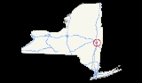
Interstate 787 is an auxiliary Interstate Highway in the U.S. state
of New York
. I-787 is the main highway for those traveling into and out of downtown Albany
. The southern terminus is at the Interstate 87/New York State Thruway
exit 23 toll plaza southwest of downtown Albany
. The northern terminus of the route is unclear, with some sources placing the terminus at 8th Street in Troy
, creating an overlap with NY 7
between Green Island
and Troy. Other documents show I-787 as terminating at its interchange with NY 7 and NY 787
in the town of Colonie. Regardless, the route is 10.16 miles (16.35 km) long if extended to Troy, or 9.55 miles (15.37 km) excluding the NY 7 overlap.
North of NY 7, the right-of-way of I-787 continues north as NY 787
to the city of Cohoes
.
 I-787 officially begins at the toll barrier for I-87/Thruway exit 23; however, a short 0.57 mile (0.9173238 km) spur between U.S. Route 9W and the interchange connecting I-787 to the Thruway, designated as NY 912S, an unsigned reference route, is signed as I-787. At the east end of the interchange (exit 1) with I-87, I-787 northbound merges with NY 912S, progressing due east for a short distance before curving to the northeast ahead of the Delaware and Hudson Railway
mainline near exit 2 (NY 32
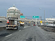
). Past NY 32, I-787 parallels the Hudson River
as it heads northward into the heart of downtown Albany, featuring a pair of exits with U.S. Route 9 and U.S. Route 20 at a massive interchange southeast of the Empire State Plaza
on the west bank of the Hudson.
North of downtown Albany, I-787 interchanges with Interstate 90 at exit 5 prior to crossing into Menands
and meeting NY 32 once more at exit 6 by way of a trumpet interchange. The ramp from the trumpet to NY 32, a 0.28 mile (0.4506152 km) long roadway, is designated as unsigned NY 913T. Farther north in Menands, I-787 intersects NY 378
(exit 7) by way of a near-cloverleaf interchange
. In Watervliet
, I-787 has one interchange with 23rd Street (exit 8) before reaching another near-cloverleaf interchange with NY 7 and NY 787 (exit 9) in Green Island. From this point, I-787's alignment becomes uncertain.
 The northern terminus of I-787 is unclear. Appendix E of the 2008 New York State Department of Transportation
(NYSDOT) Traffic Data Report places the terminus at 8th Street in Troy, creating an overlap with NY 7
across the Hudson River
via the Collar City Bridge
. Additionally, there are shields for I-787 on the Collar City Bridge
east of the Hudson River
. Other sources, including the National Highway System
map of Albany published by the Federal Highway Administration
and NYSDOT's official description of signed routes in New York State, identifies the terminus as the NY 7 / NY 787
interchange near Green Island. Contemporary maps of the Albany area also lack I-787 shields on the Collar City Bridge, signing the roadway only as NY 7.
According to the NYSDOT traffic counts, I-787 is 10.16 miles (16.35 km) long; by limiting I-787 to the section between the Thruway and NY 7, the length is reduced to 9.55 miles (15.37 km).
. The portion of the highway between I-90 and NY 378
was completed by 1971; the rest of I-787 south of 23rd Street in Watervliet was built and open to traffic by 1973. The ramps from the South Mall Arterial
were opened in 1974. An extension of the freeway north to Arch Street near Green Island
was completed by 1977. By 1980, the majority of modern exit 9 was completed even though the Collar City Bridge
and the "Alternate Route 7" freeway had yet to be constructed. The Collar City Bridge over the Hudson River
was built in 1981, connecting the pre-existing ramps at exit 9 to downtown Troy
.
When I-787 was first planned, its northern terminus was at U.S. Route 4 in Troy. On January 1, 1970, the I-787 designation was truncated westward to what is now exit 9 near Green Island while the then-proposed Collar City Bridge became (albeit on paper) part of Interstate 88
, a new highway extending from Binghamton to Troy by way of the Susquehanna Expressway and Alternate Route 7. The extension of I-88 never materialized as Alternate Route 7 ended up becoming a realignment of NY 7 when it was completed in the 1980s.
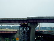 In 2005, an elevated section of the northbound exit 3 off ramp slipped off its supports, causing temporary closure of the ramp and causing disruption of the flow of traffic into the Empire State Plaza
. The ramp connects I-787 with the South Mall Arterial
. Initially, most roads and ramps near or under the elevated highway were closed, but once temporary piers were in place, most roads reopened. A detour was set up to allow northbound traffic to enter the Plaza, but it required crossing the Hudson River
over the Dunn Memorial Bridge
and traveling through the city of Rensselaer
to get back on the bridge, allowing access into the Plaza. The slip caused the south end of a simple span of the overpass to drop about 2 foot (0.6096 m). The pier stands 80 feet (24.4 m) tall at the slippage point. Nobody was hurt, but the woman that discovered the drop was shaken.
|rowspan=12|Albany
|rowspan=8|Albany
|0.00
|
|
|Southbound exit and northbound entrance; signed as exit 1 southbound
|-
|0.32
|1
|
|Unnumbered exit southbound
|-
|0.94
|2
|
|
|-
|1.97
|3A
|
|Signed as exit 3 northbound
|-
|2.40
|3B
|
|Signed as exit 4 northbound
|-
|
|4B
|
|Northbound exit is part of exit 4
|-
|
|4A
|Colonie Street, Columbia Street
|No northbound entrance; northbound exit is part of exit 4
|-
|3.36
|5
|
|
|-
|rowspan=2|Menands
|4.20
|6
|
|
|-
|6.27
|7
|, Menands
|Signed as exits 7E (east) and 7W (west); serves Hudson Valley Community College
and Joseph L. Bruno Stadium
|-
|Watervliet
|8.91
|8
|23rd Street – Watervliet
, Green Island
|Connects to NY 2
|-
|Colonie
|9.55
|9W
|
|South end of NY 7 overlap
|-
|rowspan=2|Rensselaer
|rowspan=2|Troy
|
|
|Downtown Troy
|Northbound exit and southbound entrance; connects to US 4
|-
|10.16
|9E
|
|Northbound exit and southbound entrance
U.S. state
A U.S. state is any one of the 50 federated states of the United States of America that share sovereignty with the federal government. Because of this shared sovereignty, an American is a citizen both of the federal entity and of his or her state of domicile. Four states use the official title of...
of New York
New York
New York is a state in the Northeastern region of the United States. It is the nation's third most populous state. New York is bordered by New Jersey and Pennsylvania to the south, and by Connecticut, Massachusetts and Vermont to the east...
. I-787 is the main highway for those traveling into and out of downtown Albany
Albany, New York
Albany is the capital city of the U.S. state of New York, the seat of Albany County, and the central city of New York's Capital District. Roughly north of New York City, Albany sits on the west bank of the Hudson River, about south of its confluence with the Mohawk River...
. The southern terminus is at the Interstate 87/New York State Thruway
New York State Thruway
The New York State Thruway is a system of limited-access highways located within the state of New York in the United States. The system, known officially as the Governor Thomas E. Dewey Thruway for former New York Governor Thomas E. Dewey, is operated by the New York State Thruway Authority and...
exit 23 toll plaza southwest of downtown Albany
Albany, New York
Albany is the capital city of the U.S. state of New York, the seat of Albany County, and the central city of New York's Capital District. Roughly north of New York City, Albany sits on the west bank of the Hudson River, about south of its confluence with the Mohawk River...
. The northern terminus of the route is unclear, with some sources placing the terminus at 8th Street in Troy
Troy, New York
Troy is a city in the US State of New York and the seat of Rensselaer County. Troy is located on the western edge of Rensselaer County and on the eastern bank of the Hudson River. Troy has close ties to the nearby cities of Albany and Schenectady, forming a region popularly called the Capital...
, creating an overlap with NY 7
New York State Route 7
New York State Route 7 is a 180-mile long New York State Highway that runs from the New York/Pennsylvania border south of Binghamton, New York to the New York/Vermont border east of Hoosick. Most of the road runs along the Susquehanna Valley, closely paralleling Interstate 88 throughout...
between Green Island
Green Island, New York
Green Island is a coterminous town and village in Albany County, New York, USA some 8 miles north of Albany, New York. Green Island is one of only five such town-village amalgams in New York. The population was 2,620 at the 2010 census...
and Troy. Other documents show I-787 as terminating at its interchange with NY 7 and NY 787
New York State Route 787
New York State Route 787 is a state highway in Albany County, New York, in the United States. It is a superhighway extension of I-787, continuing northward from the underpass at exit 9 for NY 7 near Green Island to downtown Cohoes at NY 32...
in the town of Colonie. Regardless, the route is 10.16 miles (16.35 km) long if extended to Troy, or 9.55 miles (15.37 km) excluding the NY 7 overlap.
North of NY 7, the right-of-way of I-787 continues north as NY 787
New York State Route 787
New York State Route 787 is a state highway in Albany County, New York, in the United States. It is a superhighway extension of I-787, continuing northward from the underpass at exit 9 for NY 7 near Green Island to downtown Cohoes at NY 32...
to the city of Cohoes
Cohoes, New York
Cohoes is an incorporated city located at the northeast corner of Albany County in the US state of New York. It is called the "Spindle City" because of the importance of textile production to its growth. As of the 2010 census, the city population was 16,168...
.
Route description
Delaware and Hudson Railway
The Delaware and Hudson Railway is a railroad that operates in the northeastern United States. Since 1991 it has been a subsidiary of the Canadian Pacific Railway, although CPR has assumed all operations and the D&H does not maintain any locomotives or rolling stock.It was formerly an important...
mainline near exit 2 (NY 32
New York State Route 32
New York State Route 32 is a north–south state highway that extends for through the Hudson Valley and Capital District regions of the U.S. state of New York. It is a two-lane surface road for nearly its entire length, with few divided and no limited-access sections. From Harriman to Albany,...
). Past NY 32, I-787 parallels the Hudson River
Hudson River
The Hudson is a river that flows from north to south through eastern New York. The highest official source is at Lake Tear of the Clouds, on the slopes of Mount Marcy in the Adirondack Mountains. The river itself officially begins in Henderson Lake in Newcomb, New York...
as it heads northward into the heart of downtown Albany, featuring a pair of exits with U.S. Route 9 and U.S. Route 20 at a massive interchange southeast of the Empire State Plaza
Empire State Plaza
The Governor Nelson A. Rockefeller Empire State Plaza is a complex of several state government buildings in downtown Albany, New York....
on the west bank of the Hudson.
North of downtown Albany, I-787 interchanges with Interstate 90 at exit 5 prior to crossing into Menands
Menands, New York
Menands is a village in Albany County, New York, United States. The population was 3,990 at the 2010 census. The village is named after Louis Menand...
and meeting NY 32 once more at exit 6 by way of a trumpet interchange. The ramp from the trumpet to NY 32, a 0.28 mile (0.4506152 km) long roadway, is designated as unsigned NY 913T. Farther north in Menands, I-787 intersects NY 378
New York State Route 378
New York State Route 378 is a state highway in the Capital District of New York in the United States. It runs from Loudonville to Troy and traverses the Hudson River via the Menands Bridge. NY 378 once connected to Menands Road in the village of Menands; however, Menands Road has since...
(exit 7) by way of a near-cloverleaf interchange
Cloverleaf interchange
A cloverleaf interchange is a two-level interchange in which left turns, reverse direction in left-driving regions, are handled by ramp roads...
. In Watervliet
Watervliet, New York
Watervliet is a city in Albany County in the US state of New York. The population was 10,254 as of the 2010 census. Watervliet is north of Albany, the capital of the state, and is bordered on the north, west, and south by the town of Colonie. The city is also known as "the Arsenal City".- History...
, I-787 has one interchange with 23rd Street (exit 8) before reaching another near-cloverleaf interchange with NY 7 and NY 787 (exit 9) in Green Island. From this point, I-787's alignment becomes uncertain.
Northern terminus
New York State Department of Transportation
The New York State Department of Transportation is responsible for the development and operation of highways, railroads, mass transit systems, ports, waterways and aviation facilities in the U.S...
(NYSDOT) Traffic Data Report places the terminus at 8th Street in Troy, creating an overlap with NY 7
New York State Route 7
New York State Route 7 is a 180-mile long New York State Highway that runs from the New York/Pennsylvania border south of Binghamton, New York to the New York/Vermont border east of Hoosick. Most of the road runs along the Susquehanna Valley, closely paralleling Interstate 88 throughout...
across the Hudson River
Hudson River
The Hudson is a river that flows from north to south through eastern New York. The highest official source is at Lake Tear of the Clouds, on the slopes of Mount Marcy in the Adirondack Mountains. The river itself officially begins in Henderson Lake in Newcomb, New York...
via the Collar City Bridge
Collar City Bridge
The Collar City Bridge carries NY 7 across the Hudson River connecting Colonie, New York with Troy, by way of passing over Green Island...
. Additionally, there are shields for I-787 on the Collar City Bridge
Collar City Bridge
The Collar City Bridge carries NY 7 across the Hudson River connecting Colonie, New York with Troy, by way of passing over Green Island...
east of the Hudson River
Hudson River
The Hudson is a river that flows from north to south through eastern New York. The highest official source is at Lake Tear of the Clouds, on the slopes of Mount Marcy in the Adirondack Mountains. The river itself officially begins in Henderson Lake in Newcomb, New York...
. Other sources, including the National Highway System
National Highway System (United States)
The National Highway System is a network of strategic highways within the United States, including the Interstate Highway System and other roads serving major airports, ports, rail or truck terminals, railway stations, pipeline terminals and other strategic transport facilities.Individual states...
map of Albany published by the Federal Highway Administration
Federal Highway Administration
The Federal Highway Administration is a division of the United States Department of Transportation that specializes in highway transportation. The agency's major activities are grouped into two "programs," the Federal-aid Highway Program and the Federal Lands Highway Program...
and NYSDOT's official description of signed routes in New York State, identifies the terminus as the NY 7 / NY 787
New York State Route 787
New York State Route 787 is a state highway in Albany County, New York, in the United States. It is a superhighway extension of I-787, continuing northward from the underpass at exit 9 for NY 7 near Green Island to downtown Cohoes at NY 32...
interchange near Green Island. Contemporary maps of the Albany area also lack I-787 shields on the Collar City Bridge, signing the roadway only as NY 7.
According to the NYSDOT traffic counts, I-787 is 10.16 miles (16.35 km) long; by limiting I-787 to the section between the Thruway and NY 7, the length is reduced to 9.55 miles (15.37 km).
History
Construction began in the early 1960s on the first segment of I-787 from Interstate 87 to Bassett Street. It was completed and opened to traffic in the mid-1960s. By 1968, construction had begun on the remainder of I-787 south of WatervlietWatervliet, New York
Watervliet is a city in Albany County in the US state of New York. The population was 10,254 as of the 2010 census. Watervliet is north of Albany, the capital of the state, and is bordered on the north, west, and south by the town of Colonie. The city is also known as "the Arsenal City".- History...
. The portion of the highway between I-90 and NY 378
New York State Route 378
New York State Route 378 is a state highway in the Capital District of New York in the United States. It runs from Loudonville to Troy and traverses the Hudson River via the Menands Bridge. NY 378 once connected to Menands Road in the village of Menands; however, Menands Road has since...
was completed by 1971; the rest of I-787 south of 23rd Street in Watervliet was built and open to traffic by 1973. The ramps from the South Mall Arterial
South Mall Arterial
The South Mall Arterial is a short expressway built in the early 1960's in Albany, New York, United States. It runs west from the interchange between Interstate 787, U.S. Route 9, and U.S. Route 20, at the west end of the Dunn Memorial Bridge, and runs under the Empire State Plaza...
were opened in 1974. An extension of the freeway north to Arch Street near Green Island
Green Island, New York
Green Island is a coterminous town and village in Albany County, New York, USA some 8 miles north of Albany, New York. Green Island is one of only five such town-village amalgams in New York. The population was 2,620 at the 2010 census...
was completed by 1977. By 1980, the majority of modern exit 9 was completed even though the Collar City Bridge
Collar City Bridge
The Collar City Bridge carries NY 7 across the Hudson River connecting Colonie, New York with Troy, by way of passing over Green Island...
and the "Alternate Route 7" freeway had yet to be constructed. The Collar City Bridge over the Hudson River
Hudson River
The Hudson is a river that flows from north to south through eastern New York. The highest official source is at Lake Tear of the Clouds, on the slopes of Mount Marcy in the Adirondack Mountains. The river itself officially begins in Henderson Lake in Newcomb, New York...
was built in 1981, connecting the pre-existing ramps at exit 9 to downtown Troy
Troy, New York
Troy is a city in the US State of New York and the seat of Rensselaer County. Troy is located on the western edge of Rensselaer County and on the eastern bank of the Hudson River. Troy has close ties to the nearby cities of Albany and Schenectady, forming a region popularly called the Capital...
.
When I-787 was first planned, its northern terminus was at U.S. Route 4 in Troy. On January 1, 1970, the I-787 designation was truncated westward to what is now exit 9 near Green Island while the then-proposed Collar City Bridge became (albeit on paper) part of Interstate 88
Interstate 88 (east)
Interstate 88 is an intrastate Interstate Highway entirely within the U.S. state of New York. Its western end is at Interstate 81 in Binghamton and its eastern end is at Interstate 90 in Schenectady. It serves as an important connector route from Albany to Binghamton, Elmira , and...
, a new highway extending from Binghamton to Troy by way of the Susquehanna Expressway and Alternate Route 7. The extension of I-88 never materialized as Alternate Route 7 ended up becoming a realignment of NY 7 when it was completed in the 1980s.
Empire State Plaza
The Governor Nelson A. Rockefeller Empire State Plaza is a complex of several state government buildings in downtown Albany, New York....
. The ramp connects I-787 with the South Mall Arterial
South Mall Arterial
The South Mall Arterial is a short expressway built in the early 1960's in Albany, New York, United States. It runs west from the interchange between Interstate 787, U.S. Route 9, and U.S. Route 20, at the west end of the Dunn Memorial Bridge, and runs under the Empire State Plaza...
. Initially, most roads and ramps near or under the elevated highway were closed, but once temporary piers were in place, most roads reopened. A detour was set up to allow northbound traffic to enter the Plaza, but it required crossing the Hudson River
Hudson River
The Hudson is a river that flows from north to south through eastern New York. The highest official source is at Lake Tear of the Clouds, on the slopes of Mount Marcy in the Adirondack Mountains. The river itself officially begins in Henderson Lake in Newcomb, New York...
over the Dunn Memorial Bridge
Dunn Memorial Bridge
The Dunn Memorial Bridge, officially known as the Private Parker F. Dunn Memorial Bridge, carries US 9 and US 20 across the Hudson River between Albany, New York and Rensselaer, New York. Completed in 1967 to replace an earlier span bearing the same name, the highway bridge has a steel girder...
and traveling through the city of Rensselaer
Rensselaer, New York
Rensselaer is a city in Rensselaer County, New York, United States, and is located on the Hudson River directly opposite Albany. As of the 2010 census, the city population was 9,392; in 1920, it was 10,832. The name is from Kiliaen van Rensselaer, the original landowner of the region in New...
to get back on the bridge, allowing access into the Plaza. The slip caused the south end of a simple span of the overpass to drop about 2 foot (0.6096 m). The pier stands 80 feet (24.4 m) tall at the slippage point. Nobody was hurt, but the woman that discovered the drop was shaken.
Future
In recent years, various proposals have been developed to completely overhaul Interstate 787, due to the fact that its current configuration cuts off the City of Albany from its downtown waterfront, thus curtailing economic growth of the region. One of these is to bury the interstate under its current footprint, the other is to elevate the highway (still in its current footprint), in order for locals to gain easier access to the Hudson River.Exit list
|-|rowspan=12|Albany
Albany County, New York
Albany County is a county located in the U.S. state of New York, and is part of the Albany-Schenectady-Troy Metropolitan Statistical Area. The name is from the title of the Duke of York and Albany, who became James II of England . As of the 2010 census, the population was 304,204...
|rowspan=8|Albany
Albany, New York
Albany is the capital city of the U.S. state of New York, the seat of Albany County, and the central city of New York's Capital District. Roughly north of New York City, Albany sits on the west bank of the Hudson River, about south of its confluence with the Mohawk River...
|0.00
|
|
|Southbound exit and northbound entrance; signed as exit 1 southbound
|-
|0.32
|1
|
|Unnumbered exit southbound
|-
|0.94
|2
|
|
|-
|1.97
|3A
|
|Signed as exit 3 northbound
|-
|2.40
|3B
|
|Signed as exit 4 northbound
|-
|
|4B
|
|Northbound exit is part of exit 4
|-
|
|4A
|Colonie Street, Columbia Street
|No northbound entrance; northbound exit is part of exit 4
|-
|3.36
|5
|
|
|-
|rowspan=2|Menands
Menands, New York
Menands is a village in Albany County, New York, United States. The population was 3,990 at the 2010 census. The village is named after Louis Menand...
|4.20
|6
|
|
|-
|6.27
|7
|, Menands
|Signed as exits 7E (east) and 7W (west); serves Hudson Valley Community College
Hudson Valley Community College
Hudson Valley Community College, a SUNY associated two-year college, is located in Troy in Rensselaer County, New York. Although about eighty percent of the students are from the local area, the remainder are from other parts of New York, other states and from some 30 countries around the...
and Joseph L. Bruno Stadium
Joseph L. Bruno Stadium
Joseph L. Bruno Stadium is a stadium in North Greenbush, New York. It is primarily used for baseball and is the home field of the Tri-City Valley Cats minor league baseball team...
|-
|Watervliet
Watervliet, New York
Watervliet is a city in Albany County in the US state of New York. The population was 10,254 as of the 2010 census. Watervliet is north of Albany, the capital of the state, and is bordered on the north, west, and south by the town of Colonie. The city is also known as "the Arsenal City".- History...
|8.91
|8
|23rd Street – Watervliet
Watervliet, New York
Watervliet is a city in Albany County in the US state of New York. The population was 10,254 as of the 2010 census. Watervliet is north of Albany, the capital of the state, and is bordered on the north, west, and south by the town of Colonie. The city is also known as "the Arsenal City".- History...
, Green Island
Green Island, New York
Green Island is a coterminous town and village in Albany County, New York, USA some 8 miles north of Albany, New York. Green Island is one of only five such town-village amalgams in New York. The population was 2,620 at the 2010 census...
|Connects to NY 2
|-
|Colonie
Colonie (town), New York
Colonie is a town in Albany County, New York, United States. It is the most populous suburb of Albany, New York, and is the third largest town in area in Albany County, occupying about 11% of the county. Several hamlets exist within the town. As of the 2010 census, the town had a total population...
|9.55
|9W
|
|South end of NY 7 overlap
|-
|rowspan=2|Rensselaer
|rowspan=2|Troy
|
|
|Downtown Troy
|Northbound exit and southbound entrance; connects to US 4
|-
|10.16
|9E
|
|Northbound exit and southbound entrance
See also
- New York State Route 787 for grade level intersections to the north.
- New York State Route 910F (Fuller Road Alternate), which was intended to connect to I-787 at I-87 and US 9W.
External links
- Capital Highways - I-787 (Chris Jordan)
- Interstate 787 Exit Listing