
New York State Route 43
Encyclopedia
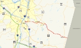
New York State Route 43 (NY 43) is a state highway
in Rensselaer County, New York
, United States
. It extends for 24 miles (38.62 km) from Interstate 90 (I-90) exit 8 in North Greenbush
to the Massachusetts
state line, where it continues into Williamstown
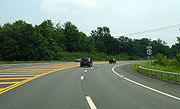
as Massachusetts Route 43. Most of NY 43 is a two-lane highway that passes through a mixture of rural and residential areas; however, its westernmost 2 miles (3.2 km) between I-90 and U.S. Route 4 (US 4) is a four-lane divided highway
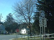
. NY 43 has an overlap with NY 66
in Sand Lake
and intersects NY 22
in Stephentown
.
When NY 43 was first assigned in the 1920s, it began near the village of Schoharie
and ended in downtown Albany
. Initially, the portion of modern NY 43 east of Averill Park was designated as part of New York State Route 7 in 1924. It was renumbered to New York State Route 45 by 1926 and became part of an extended NY 43 as part of the 1930 renumbering of state highways in New York. NY 43 was originally routed on Broadway and Washington Avenue in Rensselaer; however, it was rerouted to use 3rd Avenue and US 4 instead in the late 1960s.
In the early 1970s, the route was truncated to consist only of the portion east of the Hudson River
. NY 43's former routing west to Schoharie was redesignated NY 443
as a result. NY 43 was realigned slightly in the late 1990s to serve the new exit 8 on I-90. Its former routing into Rensselaer on 3rd Avenue is now partly NY 151
and unsigned NY 915E
.
in western Rensselaer County
. The route heads northeastward as a four-lane divided highway
through a small forest separating NY 43 from a pair of residential neighborhoods. NY 43 provides access to these neighborhoods at an intersection with Washington Avenue. Past this junction, the highway turns eastward to meet US 4 in the hamlet of Defreestville. NY 43 narrows to two lanes roughly 0.25 mile (0.402335 km) east of US 4 and continues eastward through a densely populated area of North Greenbush.
 East of Lape Road (County Route 66 or CR 66), the amount of development along NY 43 begins to decline and give way to small, open fields located amongst forested areas. However, as NY 43 enters the town of Sand Lake
, the number of homes and businesses on the highway rises once more. The level of development reaches its greatest point in West Sand Lake
, a community centered around NY 43's junction with NY 150
. NY 43 continues on, passing through residential areas of Sand Lake as it intersects NY 351
and heads eastward to Averill Park. The route meets NY 66
east of the community, and the two routes overlap for 3 miles (5 km) southeastward along the eastern shores of the small Glass and Crooked Lakes. NY 43 and NY 66 split just after crossing into the town of Nassau
near the southern edge of Crooked Lake.
NY 43 heads southeastward from NY 66, passing through mostly rural, forested areas as it proceeds toward the Massachusetts
state line. Most of the development along the final stretch of the route is concentrated in the small communities along the route. It passes through Dunham Hollow and enters the town of Stephentown
as it serves the hamlet of West Stephentown. NY 43 continues through forested areas of Stephentown to Stephentown Center, denoted by a cluster of homes near the intersection of NY 43 and Newton Road.
From Stephentown Center, the route heads southeast to the community of Stephentown situated 2 miles (3.2 km) west of the state line. NY 43 serves as the main commercial strip through the hamlet, which is the largest location on the route since Averill Park. Here, NY 43 intersects NY 22
at a junction that features sharp corners for commuters turning onto NY 43 from NY 22. Past NY 22, NY 43 heads southeast through mostly open fields and lightly populated areas to the Massachusetts state line, where the roadway becomes Route 43 upon crossing into Williamstown, Massachusetts
.
 In 1908, the New York State Legislature created a system of unsigned legislative route
s across the state of New York
. Two of the routes created at this time were Route 7, which extended from the Pennsylvania
state line south of Binghamton
to Albany
via Oneonta, Cobleskill, Berne
, and New Scotland
, and Route 24, a highway extending from the east bank of the Hudson River
in Rensselaer
to the Massachusetts
state line near Mount Lebanon by way of Averill Park and Nassau
. In the vicinity of Rensselaer, Route 21 was routed on 3rd Avenue, 3rd Avenue Extension, North Greenbush Road, and West Sand Lake Road.
When the first set of posted routes in New York were assigned in 1924, a highway connecting Route 21 in Averill Park to the Massachusetts state line at Stephentown
was designated as part of NY 7, a route that continued northwest from Averill Park to Troy
on modern NY 66
. By 1926, the portion of old legislative Route 7 from Central Bridge to East Berne was designated as part of NY 43, a new route extending from Central Bridge to downtown Albany via East Berne, Clarksville, and Delmar
, while NY 7 was renumbered to NY 45.
north of Schoharie
. Meanwhile, NY 45 was reassigned to another highway in Orange County
. The portion of former NY 45 from Troy to Averill Park became part of NY 66 while the remainder became an eastward extension of NY 43. The extended NY 43 was now concurrent
with US 9 and US 20 along Madison Avenue from Delaware Avenue to Rensselaer, where it followed Broadway and Washington Avenue to US 4 in Defreestville. The route continued east to Averill Park on what had been legislative Route 21.
 NY 43 was extended slightly following the construction of a new alignment for NY 30 near Central Bridge in the early 1940s. NY 30 now left its old alignment southeast of Central Bridge and bypassed the community to the east. The former routing of NY 30 into Central Bridge became an extension of NY 43, which overlapped NY 30 between the new alignment and Schoharie. When NY 30A
replaced NY 148 in the late 1950s, the short piece of NY 43 near Central Bridge became part of NY 30A and NY 43 was truncated back to NY 30 near Schoharie. In the late 1960s, NY 43 was rerouted through downtown Rensselaer to follow 3rd Avenue (previously NY 381) east to US 4. From there, NY 43 overlapped US 4 northward to Defreestville, where it rejoined its previous alignment.
NY 43 was truncated on its western end to the junction of 3rd Avenue and Broadway in downtown Rensselaer in the early 1970s, eliminating the overlap with US 9 and US 20 through Albany. Its former routing from Schoharie to Albany was renumbered to NY 443
. NY 43 remained on 3rd Avenue up to the late 1990s when it was rerouted to follow a new highway to I-90 exit 8 west of Defreestville. The realignment eliminated the overlap with US 4 and also took NY 43 outside of the Rensselaer city limits for the first time since being extended across the Hudson River
in 1930. The former alignment of NY 43 along 3rd Street from Broadway to Barracks Road became part of NY 151
; the remainder was designated NY 915E
, an unsigned reference route.
State highway
State highway, state road or state route can refer to one of three related concepts, two of them related to a state or provincial government in a country that is divided into states or provinces :#A...
in Rensselaer County, New York
Rensselaer County, New York
Rensselaer County is a county in the U.S. state of New York. As of the 2010 census, the population was 159,429. Its name is in honor of the family of Kiliaen van Rensselaer, the original Dutch owner of the land in the area. Its county seat is Troy...
, United States
United States
The United States of America is a federal constitutional republic comprising fifty states and a federal district...
. It extends for 24 miles (38.62 km) from Interstate 90 (I-90) exit 8 in North Greenbush
North Greenbush, New York
North Greenbush is a town in Rensselaer County, New York, United States. North Greenbush is located in the western part of the county. The population was 10,805 at the 2000 census....
to the Massachusetts
Massachusetts
The Commonwealth of Massachusetts is a state in the New England region of the northeastern United States of America. It is bordered by Rhode Island and Connecticut to the south, New York to the west, and Vermont and New Hampshire to the north; at its east lies the Atlantic Ocean. As of the 2010...
state line, where it continues into Williamstown
Williamstown, Massachusetts
Williamstown is a town in Berkshire County, in the northwest corner of Massachusetts. It shares a border with Vermont to the north and New York to the west. It is part of the Pittsfield, Massachusetts Metropolitan Statistical Area. The population was 7,754 at the 2010 census...
as Massachusetts Route 43. Most of NY 43 is a two-lane highway that passes through a mixture of rural and residential areas; however, its westernmost 2 miles (3.2 km) between I-90 and U.S. Route 4 (US 4) is a four-lane divided highway
Divided Highway
Divided Highway is a compilation album by American rock band The Doobie Brothers, released in 2003. . All tracks are taken from the albums Cycles and Brotherhood .-Track listing:...
. NY 43 has an overlap with NY 66
New York State Route 66
New York State Route 66 is a state highway in the Capital District of New York in the United States. The route begins at an intersection with NY 23B in the Columbia County city of Hudson and ends at a junction with NY 2 in the Rensselaer County city of Troy...
in Sand Lake
Sand Lake, New York
Sand Lake is a town in Rensselaer County, New York, United States. As of the 2000 census, the town had a population of 7,987. The Capital District Regional Planning Commission indicates it to be 8,336 as of September 2010. The town is in the south-central part of the county...
and intersects NY 22
New York State Route 22
New York State Route 22 is a north–south state highway in eastern New York in the United States. It runs parallel to the state's eastern edge from the outskirts of New York City to a short distance south of the Canadian border. At , it is the state's longest north–south route and...
in Stephentown
Stephentown, New York
Stephentown is a town in Rensselaer County, New York, United States. The population was 2,873 at the 2000 census. The town is named after Stephen Van Rensselaer. The town is in the southeast corner of the county...
.
When NY 43 was first assigned in the 1920s, it began near the village of Schoharie
Schoharie (village), New York
Schoharie is a village in Schoharie County, New York, USA. The population was 1,030 at the 2000 census. It is the county seat of Schoharie County...
and ended in downtown Albany
Albany, New York
Albany is the capital city of the U.S. state of New York, the seat of Albany County, and the central city of New York's Capital District. Roughly north of New York City, Albany sits on the west bank of the Hudson River, about south of its confluence with the Mohawk River...
. Initially, the portion of modern NY 43 east of Averill Park was designated as part of New York State Route 7 in 1924. It was renumbered to New York State Route 45 by 1926 and became part of an extended NY 43 as part of the 1930 renumbering of state highways in New York. NY 43 was originally routed on Broadway and Washington Avenue in Rensselaer; however, it was rerouted to use 3rd Avenue and US 4 instead in the late 1960s.
In the early 1970s, the route was truncated to consist only of the portion east of the Hudson River
Hudson River
The Hudson is a river that flows from north to south through eastern New York. The highest official source is at Lake Tear of the Clouds, on the slopes of Mount Marcy in the Adirondack Mountains. The river itself officially begins in Henderson Lake in Newcomb, New York...
. NY 43's former routing west to Schoharie was redesignated NY 443
New York State Route 443
New York State Route 443 is an east–west state highway in the Capital District of New York in the United States. The route begins at an intersection with NY 30 in the town of Schoharie and ends later at a junction with U.S. Route 9W and US 20 in the city of Albany...
as a result. NY 43 was realigned slightly in the late 1990s to serve the new exit 8 on I-90. Its former routing into Rensselaer on 3rd Avenue is now partly NY 151
New York State Route 151
New York State Route 151 is an state highway located in Rensselaer County, New York, in the United States. Its western terminus is at an interchange with U.S. Route 9 and US 20 in Rensselaer, and its eastern terminus is at a junction with NY 150 in Shivers Corners, a hamlet...
and unsigned NY 915E
New York State Route 915E
New York State Route 915E is an unsigned reference route designation for Third Avenue Extension in East Greenbush, located in Rensselaer County, New York, in the United States. The east–west highway extends for from an intersection with NY 151 east of the Rensselaer city limits to a...
.
Route description
NY 43 begins at an interchange with I-90 (exit 8) in the town of North GreenbushNorth Greenbush, New York
North Greenbush is a town in Rensselaer County, New York, United States. North Greenbush is located in the western part of the county. The population was 10,805 at the 2000 census....
in western Rensselaer County
Rensselaer County, New York
Rensselaer County is a county in the U.S. state of New York. As of the 2010 census, the population was 159,429. Its name is in honor of the family of Kiliaen van Rensselaer, the original Dutch owner of the land in the area. Its county seat is Troy...
. The route heads northeastward as a four-lane divided highway
Divided Highway
Divided Highway is a compilation album by American rock band The Doobie Brothers, released in 2003. . All tracks are taken from the albums Cycles and Brotherhood .-Track listing:...
through a small forest separating NY 43 from a pair of residential neighborhoods. NY 43 provides access to these neighborhoods at an intersection with Washington Avenue. Past this junction, the highway turns eastward to meet US 4 in the hamlet of Defreestville. NY 43 narrows to two lanes roughly 0.25 mile (0.402335 km) east of US 4 and continues eastward through a densely populated area of North Greenbush.
Sand Lake, New York
Sand Lake is a town in Rensselaer County, New York, United States. As of the 2000 census, the town had a population of 7,987. The Capital District Regional Planning Commission indicates it to be 8,336 as of September 2010. The town is in the south-central part of the county...
, the number of homes and businesses on the highway rises once more. The level of development reaches its greatest point in West Sand Lake
West Sand Lake, New York
West Sand Lake is a hamlet in Rensselaer County, New York, United States. The population was 2,439 at the 2000 census. The community is located in the northwest corner of the town of Sand Lake.- Past residents of note :...
, a community centered around NY 43's junction with NY 150
New York State Route 150
New York State Route 150 is a north–south state highway in Rensselaer County, New York, United States. The southern terminus of the route is at NY 9J in Castleton-on-Hudson...
. NY 43 continues on, passing through residential areas of Sand Lake as it intersects NY 351
New York State Route 351
New York State Route 351 is a north–south state highway in central Rensselaer County, New York, in the United States. It extends for from an intersection with NY 43 in the Sand Lake hamlet of West Sand Lake to a junction with NY 2 in the Brunswick hamlet of Cropseyville...
and heads eastward to Averill Park. The route meets NY 66
New York State Route 66
New York State Route 66 is a state highway in the Capital District of New York in the United States. The route begins at an intersection with NY 23B in the Columbia County city of Hudson and ends at a junction with NY 2 in the Rensselaer County city of Troy...
east of the community, and the two routes overlap for 3 miles (5 km) southeastward along the eastern shores of the small Glass and Crooked Lakes. NY 43 and NY 66 split just after crossing into the town of Nassau
Nassau (town), New York
Nassau is a town in Rensselaer County, New York, USA. The population was 4,818 at the 2000 census.The Town of Nassau is at the southern border of the county.- History :The region was first settled around 1760....
near the southern edge of Crooked Lake.
NY 43 heads southeastward from NY 66, passing through mostly rural, forested areas as it proceeds toward the Massachusetts
Massachusetts
The Commonwealth of Massachusetts is a state in the New England region of the northeastern United States of America. It is bordered by Rhode Island and Connecticut to the south, New York to the west, and Vermont and New Hampshire to the north; at its east lies the Atlantic Ocean. As of the 2010...
state line. Most of the development along the final stretch of the route is concentrated in the small communities along the route. It passes through Dunham Hollow and enters the town of Stephentown
Stephentown, New York
Stephentown is a town in Rensselaer County, New York, United States. The population was 2,873 at the 2000 census. The town is named after Stephen Van Rensselaer. The town is in the southeast corner of the county...
as it serves the hamlet of West Stephentown. NY 43 continues through forested areas of Stephentown to Stephentown Center, denoted by a cluster of homes near the intersection of NY 43 and Newton Road.
From Stephentown Center, the route heads southeast to the community of Stephentown situated 2 miles (3.2 km) west of the state line. NY 43 serves as the main commercial strip through the hamlet, which is the largest location on the route since Averill Park. Here, NY 43 intersects NY 22
New York State Route 22
New York State Route 22 is a north–south state highway in eastern New York in the United States. It runs parallel to the state's eastern edge from the outskirts of New York City to a short distance south of the Canadian border. At , it is the state's longest north–south route and...
at a junction that features sharp corners for commuters turning onto NY 43 from NY 22. Past NY 22, NY 43 heads southeast through mostly open fields and lightly populated areas to the Massachusetts state line, where the roadway becomes Route 43 upon crossing into Williamstown, Massachusetts
Williamstown, Massachusetts
Williamstown is a town in Berkshire County, in the northwest corner of Massachusetts. It shares a border with Vermont to the north and New York to the west. It is part of the Pittsfield, Massachusetts Metropolitan Statistical Area. The population was 7,754 at the 2010 census...
.
Origins and designation
Legislative route
In United States, a legislative route or legislative highway is a highway defined by laws passed in a state legislature. The numbering of such highways may or may not correspond to the numbers familiar to the public as part of the state, U.S. highway, and Interstate highway systems...
s across the state of New York
New York
New York is a state in the Northeastern region of the United States. It is the nation's third most populous state. New York is bordered by New Jersey and Pennsylvania to the south, and by Connecticut, Massachusetts and Vermont to the east...
. Two of the routes created at this time were Route 7, which extended from the Pennsylvania
Pennsylvania
The Commonwealth of Pennsylvania is a U.S. state that is located in the Northeastern and Mid-Atlantic regions of the United States. The state borders Delaware and Maryland to the south, West Virginia to the southwest, Ohio to the west, New York and Ontario, Canada, to the north, and New Jersey to...
state line south of Binghamton
Binghamton, New York
Binghamton is a city in the Southern Tier of New York in the United States. It is near the Pennsylvania border, in a bowl-shaped valley at the confluence of the Susquehanna and Chenango Rivers...
to Albany
Albany, New York
Albany is the capital city of the U.S. state of New York, the seat of Albany County, and the central city of New York's Capital District. Roughly north of New York City, Albany sits on the west bank of the Hudson River, about south of its confluence with the Mohawk River...
via Oneonta, Cobleskill, Berne
Berne, New York
Berne is a town in Albany County, New York, United States. The population was 2,794 at the 2010 census. The town is at the west border of Albany County.- History :...
, and New Scotland
New Scotland, New York
New Scotland is a town in Albany County, New York, United States. The population was 8,648 at the 2010 census.The town is southwest of Albany, New York, the state capital. New Scotland is centrally located in the county.-History:...
, and Route 24, a highway extending from the east bank of the Hudson River
Hudson River
The Hudson is a river that flows from north to south through eastern New York. The highest official source is at Lake Tear of the Clouds, on the slopes of Mount Marcy in the Adirondack Mountains. The river itself officially begins in Henderson Lake in Newcomb, New York...
in Rensselaer
Rensselaer, New York
Rensselaer is a city in Rensselaer County, New York, United States, and is located on the Hudson River directly opposite Albany. As of the 2010 census, the city population was 9,392; in 1920, it was 10,832. The name is from Kiliaen van Rensselaer, the original landowner of the region in New...
to the Massachusetts
Massachusetts
The Commonwealth of Massachusetts is a state in the New England region of the northeastern United States of America. It is bordered by Rhode Island and Connecticut to the south, New York to the west, and Vermont and New Hampshire to the north; at its east lies the Atlantic Ocean. As of the 2010...
state line near Mount Lebanon by way of Averill Park and Nassau
Nassau (village), New York
Nassau is a village located in the Town of Nassau in Rensselaer County, New York, USA. The population was 1,161 at the 2000 census.The Village of Nassau is in the south part of the county in the Town of Nassau...
. In the vicinity of Rensselaer, Route 21 was routed on 3rd Avenue, 3rd Avenue Extension, North Greenbush Road, and West Sand Lake Road.
When the first set of posted routes in New York were assigned in 1924, a highway connecting Route 21 in Averill Park to the Massachusetts state line at Stephentown
Stephentown, New York
Stephentown is a town in Rensselaer County, New York, United States. The population was 2,873 at the 2000 census. The town is named after Stephen Van Rensselaer. The town is in the southeast corner of the county...
was designated as part of NY 7, a route that continued northwest from Averill Park to Troy
Troy, New York
Troy is a city in the US State of New York and the seat of Rensselaer County. Troy is located on the western edge of Rensselaer County and on the eastern bank of the Hudson River. Troy has close ties to the nearby cities of Albany and Schenectady, forming a region popularly called the Capital...
on modern NY 66
New York State Route 66
New York State Route 66 is a state highway in the Capital District of New York in the United States. The route begins at an intersection with NY 23B in the Columbia County city of Hudson and ends at a junction with NY 2 in the Rensselaer County city of Troy...
. By 1926, the portion of old legislative Route 7 from Central Bridge to East Berne was designated as part of NY 43, a new route extending from Central Bridge to downtown Albany via East Berne, Clarksville, and Delmar
Delmar, New York
Delmar is a hamlet in the town of Bethlehem, Albany County, New York. A census-designated place has been established since 1980 by the US Bureau of Census for tabulating the population of what the census has defined as the boundaries of the urbanized area in and around Delmar. The population was...
, while NY 7 was renumbered to NY 45.
Changes in routing
In the 1930 renumbering of state highways in New York, NY 43 was truncated slightly on its western end to begin at a junction with the new NY 30New York State Route 30
New York State Route 30 is a state highway in the central part of New York in the United States. It extends for from an interchange with NY 17 in the Southern Tier to the Canadian border in the state's North Country, where it continues into Quebec as Route 138. On a regional level,...
north of Schoharie
Schoharie (village), New York
Schoharie is a village in Schoharie County, New York, USA. The population was 1,030 at the 2000 census. It is the county seat of Schoharie County...
. Meanwhile, NY 45 was reassigned to another highway in Orange County
Orange County, New York
Orange County is a county located in the U.S. state of New York. It is part of the Poughkeepsie–Newburgh–Middletown, NY Metropolitan Statistical Area and is located at the northern reaches of the New York metropolitan area. The county sits in the state's scenic Mid-Hudson Region of the Hudson Valley...
. The portion of former NY 45 from Troy to Averill Park became part of NY 66 while the remainder became an eastward extension of NY 43. The extended NY 43 was now concurrent
Concurrency (road)
A concurrency, overlap, or coincidence in a road network is an instance of one physical road bearing two or more different highway, motorway, or other route numbers...
with US 9 and US 20 along Madison Avenue from Delaware Avenue to Rensselaer, where it followed Broadway and Washington Avenue to US 4 in Defreestville. The route continued east to Averill Park on what had been legislative Route 21.
New York State Route 30A
New York State Route 30A is a state highway in the Capital District of New York in the United States. It serves as a westerly alternate route of NY 30 from near the Schoharie County village of Schoharie to the Fulton County hamlet of Riceville, south of the village of Mayfield...
replaced NY 148 in the late 1950s, the short piece of NY 43 near Central Bridge became part of NY 30A and NY 43 was truncated back to NY 30 near Schoharie. In the late 1960s, NY 43 was rerouted through downtown Rensselaer to follow 3rd Avenue (previously NY 381) east to US 4. From there, NY 43 overlapped US 4 northward to Defreestville, where it rejoined its previous alignment.
NY 43 was truncated on its western end to the junction of 3rd Avenue and Broadway in downtown Rensselaer in the early 1970s, eliminating the overlap with US 9 and US 20 through Albany. Its former routing from Schoharie to Albany was renumbered to NY 443
New York State Route 443
New York State Route 443 is an east–west state highway in the Capital District of New York in the United States. The route begins at an intersection with NY 30 in the town of Schoharie and ends later at a junction with U.S. Route 9W and US 20 in the city of Albany...
. NY 43 remained on 3rd Avenue up to the late 1990s when it was rerouted to follow a new highway to I-90 exit 8 west of Defreestville. The realignment eliminated the overlap with US 4 and also took NY 43 outside of the Rensselaer city limits for the first time since being extended across the Hudson River
Hudson River
The Hudson is a river that flows from north to south through eastern New York. The highest official source is at Lake Tear of the Clouds, on the slopes of Mount Marcy in the Adirondack Mountains. The river itself officially begins in Henderson Lake in Newcomb, New York...
in 1930. The former alignment of NY 43 along 3rd Street from Broadway to Barracks Road became part of NY 151
New York State Route 151
New York State Route 151 is an state highway located in Rensselaer County, New York, in the United States. Its western terminus is at an interchange with U.S. Route 9 and US 20 in Rensselaer, and its eastern terminus is at a junction with NY 150 in Shivers Corners, a hamlet...
; the remainder was designated NY 915E
New York State Route 915E
New York State Route 915E is an unsigned reference route designation for Third Avenue Extension in East Greenbush, located in Rensselaer County, New York, in the United States. The east–west highway extends for from an intersection with NY 151 east of the Rensselaer city limits to a...
, an unsigned reference route.