

Protected areas of Wales
Encyclopedia
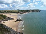
Many parts of Wales
are protected area
s, according to a number of designations. They include three national park
s, and five Areas of Outstanding Natural Beauty
.
.jpg)
Wales is home to three national park
s.
Snowdonia National Park was established in 1951 as the third National Park
in Britain, following the Peak District
and the Lake District
. It covers 827 square miles (2,141.9 km²), and has 37 miles (59.5 km) of coastline.
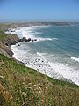
Pembrokeshire Coast National Park
() is a national park
along the Pembrokeshire
coast in West Wales
. It was established as a National Park in 1952, and is the only one in the United Kingdom
to have been designated primarily because of its spectacular coastline. It covers an area of 629 square kilometres (242.9 sq mi).
Brecon Beacons National Park (), founded in 1957, stretching from Llandeilo
in the west to Hay-on-Wye
in the east, covering 1344 square kilometres (518.9 sq mi) and encompassing four main regions – the Black Mountain
in the west, Fforest Fawr
and the Brecon Beacons in the centre, and the Black Mountains
in the east.
Five areas of outstanding natural beauty
(AONB) have been designated in Wales, one of which, the Wye Valley
AONB, straddles the Anglo-Welsh border
.
The Gower Peninsula
() is a peninsula
on the south west coast of Wales, on the north side of the Bristol Channel
in the southwest of the historic county of Glamorgan
. Referred to colloquially as 'the Gower', this was the first area in the United Kingdom to be designated as an AONB, in 1956, and covers 188 square kilometres (72.6 sq mi).
The Llŷn Peninsula
() extends 30 miles (48.3 km) into the Irish Sea
from north west Wales
, south west of the Isle of Anglesey. Much of the coastline and the ex-volcanic hills are part of the Llŷn AONB, confirming the peninsula as one of the most scientifically important in both Wales and Britain. The AONB was created in 1956, and covers 155 square kilometres (59.8 sq mi).
Anglesey
() was designated an AONB in 1966, in order to protect the aesthetic appeal and variety of the island's coastal landscape and habitats from inappropriate development. The AONB covers most of Anglesey’s 125 miles (201 km) coastline, as well as inland areas, such as Holyhead Mountain
and Mynydd Bodafon
. The AONB covers around 221 square kilometres (85.3 sq mi), about a third of the county, making it Wales' largest AONB.
The Wye Valley
AONB, designated in 1971, is an internationally important protected landscape straddling the border between England and Wales
. It is one of the most dramatic and scenic landscape areas in southern Britain. The River Wye
() is the fifth-longest river in the United Kingdom. The upper part of the river passes through the settlements of Rhayader
, Builth Wells
and Hay-on-Wye
, but the area designated as an AONB surrounds only the 58-mile stretch lower down the river, from just south of the city of Hereford
to Chepstow
.
The Clwydian Range
() is a series of hill
s and mountains in north east Wales that runs from Llandegla
in the south to Prestatyn
in the north, with the highest point being the popular Moel Famau
. It was designated as an AONB in 1985.
There are fourteen heritage coasts in Wales. They are "stretches of outstanding, undeveloped coast in England and Wales", which are not protected by law (except where covered by other protected areas), but are given special consideration by planning authorities. They are:
(SSSI) is a conservation designation
denoting a protected area
in the United Kingdom
. SSSIs are the basic building block of site-based nature conservation legislation
and most other legal nature/geological conservation designations in Great Britain
are based upon them, including National Nature Reserve
s, Ramsar Site
s, Special Protection Area
s, and Special Areas of Conservation
. Sites notified for their biological interest are known as Biological SSSIs, and those notified for geological or physiographic interest are Geological SSSIs. Many SSSIs are notified for both biological and geological interest.
Lists of SSSIs:
(SAC) is defined in the European Union
's Habitats Directive (92/43/EEC), also known as the Directive on the Conservation of Natural Habitats and of Wild Fauna and Flora. They are to protect the 220 habitats and approximately 1000 species listed in annex I and II of the directive which are considered to be of European interest following criteria given in the directive. They must be chosen from the Sites of Community Importance
by the State Members and designated SAC by an act assuring the conservation measures of the natural habitat.
(SPA) is a designation under the European Union
Directive on the Conservation of Wild Birds
. Under the Directive, Member States of the European Union
(EU) have a duty to safeguard the habitats
of migratory birds
and certain particularly threatened birds. Together with Special Areas of Conservation
(SACs), the SPAs form a network of protected sites across the EU, called Natura 2000
. Each SPA has an EU code – for example the Burry Inlet SPA has the code UK9015011.
Scheduled monuments in Wales are in the care of Cadw
, the historic environment service of the Welsh Assembly Government
.
s (LNR) have their origin in the recommendations of the Wild Life Conservation Special Committee (Conservation of Nature in England and Wales, Command 7122, 1947) which established the framework for nature conservation in the United Kingdom and suggested a national suite of protected areas comprising National Nature Reserves, Conservation Areas (which incorporated suggestions for Sites of Special Scientific Interest), National Parks, Geological Monuments, Local Nature Reserves and Local Educational Nature Reserves. There are now 73 LNRs in Wales, covering 55.6 square kilometres (21.5 sq mi).
Wales
Wales is a country that is part of the United Kingdom and the island of Great Britain, bordered by England to its east and the Atlantic Ocean and Irish Sea to its west. It has a population of three million, and a total area of 20,779 km²...
are protected area
Protected area
Protected areas are locations which receive protection because of their recognised natural, ecological and/or cultural values. There are several kinds of protected areas, which vary by level of protection depending on the enabling laws of each country or the regulations of the international...
s, according to a number of designations. They include three national park
National park
A national park is a reserve of natural, semi-natural, or developed land that a sovereign state declares or owns. Although individual nations designate their own national parks differently A national park is a reserve of natural, semi-natural, or developed land that a sovereign state declares or...
s, and five Areas of Outstanding Natural Beauty
Area of Outstanding Natural Beauty
An Area of Outstanding Natural Beauty is an area of countryside considered to have significant landscape value in England, Wales or Northern Ireland, that has been specially designated by the Countryside Agency on behalf of the United Kingdom government; the Countryside Council for Wales on...
.
National parks
Wales is home to three national park
National park
A national park is a reserve of natural, semi-natural, or developed land that a sovereign state declares or owns. Although individual nations designate their own national parks differently A national park is a reserve of natural, semi-natural, or developed land that a sovereign state declares or...
s.
Snowdonia National Park was established in 1951 as the third National Park
National parks of England and Wales
The national parks of England and Wales are areas of relatively undeveloped and scenic landscape that are designated under the National Parks and Access to the Countryside Act 1949...
in Britain, following the Peak District
Peak District
The Peak District is an upland area in central and northern England, lying mainly in northern Derbyshire, but also covering parts of Cheshire, Greater Manchester, Staffordshire, and South and West Yorkshire....
and the Lake District
Lake District
The Lake District, also commonly known as The Lakes or Lakeland, is a mountainous region in North West England. A popular holiday destination, it is famous not only for its lakes and its mountains but also for its associations with the early 19th century poetry and writings of William Wordsworth...
. It covers 827 square miles (2,141.9 km²), and has 37 miles (59.5 km) of coastline.
Pembrokeshire Coast National Park
Pembrokeshire Coast National Park
Pembrokeshire Coast National Park is a national park along the Pembrokeshire coast in West Wales.It was established as a National Park in 1952, and is the only one in the United Kingdom to have been designated primarily because of its spectacular coastline...
() is a national park
National parks of England and Wales
The national parks of England and Wales are areas of relatively undeveloped and scenic landscape that are designated under the National Parks and Access to the Countryside Act 1949...
along the Pembrokeshire
Pembrokeshire
Pembrokeshire is a county in the south west of Wales. It borders Carmarthenshire to the east and Ceredigion to the north east. The county town is Haverfordwest where Pembrokeshire County Council is headquartered....
coast in West Wales
West Wales
West Wales is the western area of Wales.Some definitions of West Wales include only Pembrokeshire, Ceredigion and Carmarthenshire, an area which historically comprised the Welsh principality of Deheubarth., an area called "South West Wales" in the Nomenclature of Territorial Units for Statistics....
. It was established as a National Park in 1952, and is the only one in the United Kingdom
United Kingdom
The United Kingdom of Great Britain and Northern IrelandIn the United Kingdom and Dependencies, other languages have been officially recognised as legitimate autochthonous languages under the European Charter for Regional or Minority Languages...
to have been designated primarily because of its spectacular coastline. It covers an area of 629 square kilometres (242.9 sq mi).
Brecon Beacons National Park (), founded in 1957, stretching from Llandeilo
Llandeilo
Llandeilo is a town in Carmarthenshire, Wales, situated at the crossing of the River Towy by the A483 on a 19th century stone bridge. Its population is 1,731.The town is served by Llandeilo railway station on the Heart of Wales Line.- Early history :...
in the west to Hay-on-Wye
Hay-on-Wye
Hay-on-Wye , often described as "the town of books", is a small market town and community in Powys, Wales.-Location:The town lies on the east bank of the River Wye and is within the Brecon Beacons National Park, just north of the Black Mountains...
in the east, covering 1344 square kilometres (518.9 sq mi) and encompassing four main regions – the Black Mountain
Black Mountain (range)
The Black Mountain is a mountain range in Mid and West Wales, straddling the county boundary between Carmarthenshire and Powys and forming the westernmost range of the Brecon Beacons National Park. Its highest point is Fan Brycheiniog at 802 metres or 2,631 ft. The Black Mountain also forms a part...
in the west, Fforest Fawr
Fforest Fawr
Fforest Fawr is the name given to an extensive upland area in the county of Powys, Wales. Formerly known as the 'Great Forest of Brecknock' in English, it was a royal hunting area for several centuries but is now used primarily for sheep grazing, forestry, water catchment and recreation...
and the Brecon Beacons in the centre, and the Black Mountains
Black Mountains, Wales
The Black Mountains are a group of hills spread across parts of Powys and Monmouthshire in southeast Wales, and extending across the national border into Herefordshire, England. They are the easternmost of the four ranges of hills that comprise the Brecon Beacons National Park, and are frequently...
in the east.
Areas of Outstanding Natural Beauty
Five areas of outstanding natural beauty
Area of Outstanding Natural Beauty
An Area of Outstanding Natural Beauty is an area of countryside considered to have significant landscape value in England, Wales or Northern Ireland, that has been specially designated by the Countryside Agency on behalf of the United Kingdom government; the Countryside Council for Wales on...
(AONB) have been designated in Wales, one of which, the Wye Valley
Wye Valley
The Wye Valley Area of Outstanding Natural Beauty is an internationally important protected landscape straddling the border between England and Wales. It is one of the most dramatic and scenic landscape areas in southern Britain....
AONB, straddles the Anglo-Welsh border
Wales–England border
The Wales–England border, between two of the countries of the United Kingdom, extends for about from the Dee estuary, in the north, to the Severn estuary in the south....
.
The Gower Peninsula
Gower Peninsula
Gower or the Gower Peninsula is a peninsula in south Wales, jutting from the coast into the Bristol Channel, and administratively part of the City and County of Swansea. Locally it is known as "Gower"...
() is a peninsula
Peninsula
A peninsula is a piece of land that is bordered by water on three sides but connected to mainland. In many Germanic and Celtic languages and also in Baltic, Slavic and Hungarian, peninsulas are called "half-islands"....
on the south west coast of Wales, on the north side of the Bristol Channel
Bristol Channel
The Bristol Channel is a major inlet in the island of Great Britain, separating South Wales from Devon and Somerset in South West England. It extends from the lower estuary of the River Severn to the North Atlantic Ocean...
in the southwest of the historic county of Glamorgan
Glamorgan
Glamorgan or Glamorganshire is one of the thirteen historic counties and a former administrative county of Wales. It was originally an early medieval kingdom of varying boundaries known as Glywysing until taken over by the Normans as a lordship. Glamorgan is latterly represented by the three...
. Referred to colloquially as 'the Gower', this was the first area in the United Kingdom to be designated as an AONB, in 1956, and covers 188 square kilometres (72.6 sq mi).
The Llŷn Peninsula
Llŷn Peninsula
The Llŷn Peninsula extends into the Irish Sea from north west Wales, south west of the Isle of Anglesey. It is part of the modern county and historic region of Gwynedd. The name is thought to be of Irish origin, and to have the same root Laigin in Irish as the word Leinster...
() extends 30 miles (48.3 km) into the Irish Sea
Irish Sea
The Irish Sea separates the islands of Ireland and Great Britain. It is connected to the Celtic Sea in the south by St George's Channel, and to the Atlantic Ocean in the north by the North Channel. Anglesey is the largest island within the Irish Sea, followed by the Isle of Man...
from north west Wales
Wales
Wales is a country that is part of the United Kingdom and the island of Great Britain, bordered by England to its east and the Atlantic Ocean and Irish Sea to its west. It has a population of three million, and a total area of 20,779 km²...
, south west of the Isle of Anglesey. Much of the coastline and the ex-volcanic hills are part of the Llŷn AONB, confirming the peninsula as one of the most scientifically important in both Wales and Britain. The AONB was created in 1956, and covers 155 square kilometres (59.8 sq mi).
Anglesey
Anglesey
Anglesey , also known by its Welsh name Ynys Môn , is an island and, as Isle of Anglesey, a county off the north west coast of Wales...
() was designated an AONB in 1966, in order to protect the aesthetic appeal and variety of the island's coastal landscape and habitats from inappropriate development. The AONB covers most of Anglesey’s 125 miles (201 km) coastline, as well as inland areas, such as Holyhead Mountain
Holyhead Mountain
Holyhead Mountain is the highest hill on Holy Island, Anglesey, and the highest in the county of Anglesey, north Wales. It lies about three kilometres west of the town of Holyhead, and slopes steeply down to the Irish Sea on two sides...
and Mynydd Bodafon
Mynydd Bodafon
Mynydd Bodafon is a mountain as the word "Mynydd" implies. However, it is actually only a hill in geographic terms, but is still the highest point on the island of Anglesey . Its summit is also known as Yr Arwydd...
. The AONB covers around 221 square kilometres (85.3 sq mi), about a third of the county, making it Wales' largest AONB.
The Wye Valley
Wye Valley
The Wye Valley Area of Outstanding Natural Beauty is an internationally important protected landscape straddling the border between England and Wales. It is one of the most dramatic and scenic landscape areas in southern Britain....
AONB, designated in 1971, is an internationally important protected landscape straddling the border between England and Wales
Wales
Wales is a country that is part of the United Kingdom and the island of Great Britain, bordered by England to its east and the Atlantic Ocean and Irish Sea to its west. It has a population of three million, and a total area of 20,779 km²...
. It is one of the most dramatic and scenic landscape areas in southern Britain. The River Wye
River Wye
The River Wye is the fifth-longest river in the UK and for parts of its length forms part of the border between England and Wales. It is important for nature conservation and recreation.-Description:...
() is the fifth-longest river in the United Kingdom. The upper part of the river passes through the settlements of Rhayader
Rhayader
Rhayader is a market town and community in Powys, Mid Wales. It has a population of 2,075, and is the first town on the banks of the River Wye, from its source on the Plynlimon range of the Cambrian Mountains....
, Builth Wells
Builth Wells
Builth Wells is a town in the county of Powys, within the historic boundaries of Brecknockshire, mid Wales, lying at the confluence of the River Wye and the River Irfon, in the Welsh of the Wye Valley. It has a population of 2,352....
and Hay-on-Wye
Hay-on-Wye
Hay-on-Wye , often described as "the town of books", is a small market town and community in Powys, Wales.-Location:The town lies on the east bank of the River Wye and is within the Brecon Beacons National Park, just north of the Black Mountains...
, but the area designated as an AONB surrounds only the 58-mile stretch lower down the river, from just south of the city of Hereford
Hereford
Hereford is a cathedral city, civil parish and county town of Herefordshire, England. It lies on the River Wye, approximately east of the border with Wales, southwest of Worcester, and northwest of Gloucester...
to Chepstow
Chepstow
Chepstow is a town in Monmouthshire, Wales, adjoining the border with Gloucestershire, England. It is located on the River Wye, close to its confluence with the River Severn, and close to the western end of the Severn Bridge on the M48 motorway...
.
The Clwydian Range
Clwydian Range
The Clwydian Range is a series of hills and mountains in north east Wales that runs from Llandegla in the south to Prestatyn in the north, with the highest point being the popular Moel Famau...
() is a series of hill
Hill
A hill is a landform that extends above the surrounding terrain. Hills often have a distinct summit, although in areas with scarp/dip topography a hill may refer to a particular section of flat terrain without a massive summit A hill is a landform that extends above the surrounding terrain. Hills...
s and mountains in north east Wales that runs from Llandegla
Llandegla
Llandegla or Llandegla-yn-Iâl is a village and community in the county of Denbighshire in Wales. In the 2001 census, the community had a population of 494.- Name :...
in the south to Prestatyn
Prestatyn
Prestatyn is a seaside resort, town and community in Denbighshire, North Wales. It is located on the Irish Sea coast, to the east of Rhyl. At the 2001 Census, Prestatyn had a population of 18,496.-Prehistory:...
in the north, with the highest point being the popular Moel Famau
Moel Famau
Moel Famau is the highest hill within the Clwydian Range on the border between Denbighshire and Flintshire in North Wales. The hill, which also gives its name to the Moel Famau country park, has been classed as an Area of Outstanding Natural Beauty since 1985...
. It was designated as an AONB in 1985.
Heritage Coast
There are fourteen heritage coasts in Wales. They are "stretches of outstanding, undeveloped coast in England and Wales", which are not protected by law (except where covered by other protected areas), but are given special consideration by planning authorities. They are:
- GlamorganGlamorganGlamorgan or Glamorganshire is one of the thirteen historic counties and a former administrative county of Wales. It was originally an early medieval kingdom of varying boundaries known as Glywysing until taken over by the Normans as a lordship. Glamorgan is latterly represented by the three...
Heritage Coast – 22.5 kilometres (14 mi) - Great OrmeGreat OrmeThe Great Orme is a prominent limestone headland on the north coast of Wales situated in Llandudno. It is referred to as Cyngreawdr Fynydd in a poem by the 12th century poet Gwalchmai ap Meilyr...
Heritage Coast - GowerGower PeninsulaGower or the Gower Peninsula is a peninsula in south Wales, jutting from the coast into the Bristol Channel, and administratively part of the City and County of Swansea. Locally it is known as "Gower"...
Heritage Coast - North Anglesey Heritage Coast – 28.6 kilometres (17.8 mi)
- Holyhead MountainHolyhead MountainHolyhead Mountain is the highest hill on Holy Island, Anglesey, and the highest in the county of Anglesey, north Wales. It lies about three kilometres west of the town of Holyhead, and slopes steeply down to the Irish Sea on two sides...
Anglesey Heritage Coast – 12.9 kilometres (8 mi) - Aberffraw Bay Anglesey Heritage Coast – 7.7 kilometres (4.8 mi)
- LlŷnLlynLlyn is the Welsh word for "lake" or, occasionally, "pond" or "pool". The word and its cognates in other Celtic languages , as well their derivatives—including lyn, lynn and lin—appear in many placenames throughout the current and former Celtic world, as, for example, in Dublin and King's...
Heritage Coast - South PembrokeshireSouth PembrokeshireSouth Pembrokeshire was one of six local government districts of Dyfed, Wales from 1974 to 1996.It was formed on April 1, 1974 under the Local Government Act 1972, from the following parts of the administrative county of Pembrokeshire:...
Heritage Coast - MarloesMarloesMarloes is a village in Pembrokeshire, West Wales. It is situated on the Marloes Peninsula 7 miles west of the port of Milford Haven and forms the westernmost tip of the southern shore of St Brides Bay. It is within part of the Pembrokeshire Coast National Park...
and DaleDale, PembrokeshireDale is a small village and community in Pembrokeshire, West Wales, located on the Dale Peninsula which forms the northern side of the entrance to Milford Haven estuary. The village has 205 inhabitants according to the 2001 census.-History:...
Pembrokeshire Heritage Coast - St Brides Bay Pembrokeshire Heritage Coast
- St Davids Peninsula Pembrokeshire Heritage Coast
- Dinas Head Pembrokeshire Heritage Coast
- St Dogmaels & Molygrove Pembrokeshire Heritage Coast
- CeredigionCeredigionCeredigion is a county and former kingdom in mid-west Wales. As Cardiganshire , it was created in 1282, and was reconstituted as a county under that name in 1996, reverting to Ceredigion a day later...
Heritage Coast – 35 kilometres (21.7 mi)
Sites of Special Scientific Interest
A Site of Special Scientific InterestSite of Special Scientific Interest
A Site of Special Scientific Interest is a conservation designation denoting a protected area in the United Kingdom. SSSIs are the basic building block of site-based nature conservation legislation and most other legal nature/geological conservation designations in Great Britain are based upon...
(SSSI) is a conservation designation
Conservation designation
A conservation designation is a name and/or acronym which explains the status of an area of land in terms of conservation or protection.-United Kingdom:*Area of Outstanding Natural Beauty *Environmentally Sensitive Area*Local Nature Reserve...
denoting a protected area
Protected area
Protected areas are locations which receive protection because of their recognised natural, ecological and/or cultural values. There are several kinds of protected areas, which vary by level of protection depending on the enabling laws of each country or the regulations of the international...
in the United Kingdom
United Kingdom
The United Kingdom of Great Britain and Northern IrelandIn the United Kingdom and Dependencies, other languages have been officially recognised as legitimate autochthonous languages under the European Charter for Regional or Minority Languages...
. SSSIs are the basic building block of site-based nature conservation legislation
Legislation
Legislation is law which has been promulgated by a legislature or other governing body, or the process of making it...
and most other legal nature/geological conservation designations in Great Britain
Great Britain
Great Britain or Britain is an island situated to the northwest of Continental Europe. It is the ninth largest island in the world, and the largest European island, as well as the largest of the British Isles...
are based upon them, including National Nature Reserve
National Nature Reserve
For details of National nature reserves in the United Kingdom see:*National Nature Reserves in England*National Nature Reserves in Northern Ireland*National Nature Reserves in Scotland*National Nature Reserves in Wales...
s, Ramsar Site
Ramsar Convention
The Ramsar Convention is an international treaty for the conservation and sustainable utilization of wetlands, i.e., to stem the progressive encroachment on and loss of wetlands now and in the future, recognizing the fundamental ecological functions of wetlands and their economic, cultural,...
s, Special Protection Area
Special Protection Area
A Special Protection Area or SPA is a designation under the European Union Directive on the Conservation of Wild Birds.Under the Directive, Member States of the European Union have a duty to safeguard the habitats of migratory birds and certain particularly threatened birds.Together with Special...
s, and Special Areas of Conservation
Special Area of Conservation
A Special Area of Conservation is defined in the European Union's Habitats Directive , also known as the Directive on the Conservation of Natural Habitats and of Wild Fauna and Flora...
. Sites notified for their biological interest are known as Biological SSSIs, and those notified for geological or physiographic interest are Geological SSSIs. Many SSSIs are notified for both biological and geological interest.
Lists of SSSIs:
- Brecknock
- Carmarthen & Dinefwr
- Ceredigion
- Clwyd
- East Gwynedd
- Gwent
- Mid & South Glamorgan
- Montgomery
- Preseli & South Pembrokeshire
- Radnor
- West Glamorgan
- West Gwynedd
Special Areas of Conservation
A Special Area of ConservationSpecial Area of Conservation
A Special Area of Conservation is defined in the European Union's Habitats Directive , also known as the Directive on the Conservation of Natural Habitats and of Wild Fauna and Flora...
(SAC) is defined in the European Union
European Union
The European Union is an economic and political union of 27 independent member states which are located primarily in Europe. The EU traces its origins from the European Coal and Steel Community and the European Economic Community , formed by six countries in 1958...
's Habitats Directive (92/43/EEC), also known as the Directive on the Conservation of Natural Habitats and of Wild Fauna and Flora. They are to protect the 220 habitats and approximately 1000 species listed in annex I and II of the directive which are considered to be of European interest following criteria given in the directive. They must be chosen from the Sites of Community Importance
Site of Community Importance
A Site of Community Importance is defined in the European Commission Habitats Directive as a site which, in the biogeographical region or regions to which it belongs, contributes significantly to the maintenance or restoration at a favourable conservation status of a natural habitat type or of a...
by the State Members and designated SAC by an act assuring the conservation measures of the natural habitat.
Special Protection Areas
A Special Protection AreaSpecial Protection Area
A Special Protection Area or SPA is a designation under the European Union Directive on the Conservation of Wild Birds.Under the Directive, Member States of the European Union have a duty to safeguard the habitats of migratory birds and certain particularly threatened birds.Together with Special...
(SPA) is a designation under the European Union
European Union
The European Union is an economic and political union of 27 independent member states which are located primarily in Europe. The EU traces its origins from the European Coal and Steel Community and the European Economic Community , formed by six countries in 1958...
Directive on the Conservation of Wild Birds
Birds Directive
The Birds Directive is a European Union directive adopted in 2009. It replaces Council Directive 79/409/EEC of 2 April 1979 on the conservation of wild birds which was modified several times and had become very unclear...
. Under the Directive, Member States of the European Union
European Union
The European Union is an economic and political union of 27 independent member states which are located primarily in Europe. The EU traces its origins from the European Coal and Steel Community and the European Economic Community , formed by six countries in 1958...
(EU) have a duty to safeguard the habitats
Habitat (ecology)
A habitat is an ecological or environmental area that is inhabited by a particular species of animal, plant or other type of organism...
of migratory birds
Bird migration
Bird migration is the regular seasonal journey undertaken by many species of birds. Bird movements include those made in response to changes in food availability, habitat or weather. Sometimes, journeys are not termed "true migration" because they are irregular or in only one direction...
and certain particularly threatened birds. Together with Special Areas of Conservation
Special Area of Conservation
A Special Area of Conservation is defined in the European Union's Habitats Directive , also known as the Directive on the Conservation of Natural Habitats and of Wild Fauna and Flora...
(SACs), the SPAs form a network of protected sites across the EU, called Natura 2000
Natura 2000
Natura 2000 is an ecological network of protected areas in the territory of the European Union.-Origins:In May 1992, the governments of the European Communities adopted legislation designed to protect the most seriously threatened habitats and species across Europe. This legislation is called the...
. Each SPA has an EU code – for example the Burry Inlet SPA has the code UK9015011.
Scheduled ancient monuments
Scheduled monuments in Wales are in the care of Cadw
Cadw
-Conservation and Protection:Many of Wales's great castles and other monuments, such as bishop's palaces, historic houses, and ruined abbeys, are now in Cadw's care. Cadw does not own them but is responsible for their upkeep and for making them accessible to the public...
, the historic environment service of the Welsh Assembly Government
Welsh Assembly Government
The Welsh Government is the devolved government of Wales. It is accountable to the National Assembly for Wales, the legislature which represents the interests of the people of Wales and makes laws for Wales...
.
Local Nature Reserves
Local Nature ReserveLocal Nature Reserve
Local nature reserve or LNR is a designation for nature reserves in the United Kingdom. The designation has its origin in the recommendations of the Wild Life Conservation Special Committee which established the framework for nature conservation in the United Kingdom and suggested a national suite...
s (LNR) have their origin in the recommendations of the Wild Life Conservation Special Committee (Conservation of Nature in England and Wales, Command 7122, 1947) which established the framework for nature conservation in the United Kingdom and suggested a national suite of protected areas comprising National Nature Reserves, Conservation Areas (which incorporated suggestions for Sites of Special Scientific Interest), National Parks, Geological Monuments, Local Nature Reserves and Local Educational Nature Reserves. There are now 73 LNRs in Wales, covering 55.6 square kilometres (21.5 sq mi).