

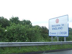
Wales–England border
Encyclopedia
Wales
Wales is a country that is part of the United Kingdom and the island of Great Britain, bordered by England to its east and the Atlantic Ocean and Irish Sea to its west. It has a population of three million, and a total area of 20,779 km²...
–England
England
England is a country that is part of the United Kingdom. It shares land borders with Scotland to the north and Wales to the west; the Irish Sea is to the north west, the Celtic Sea to the south west, with the North Sea to the east and the English Channel to the south separating it from continental...
border
Border
Borders define geographic boundaries of political entities or legal jurisdictions, such as governments, sovereign states, federated states and other subnational entities. Some borders—such as a state's internal administrative borders, or inter-state borders within the Schengen Area—are open and...
, between two of the countries of the United Kingdom
Countries of the United Kingdom
Countries of the United Kingdom is a term used to describe England, Northern Ireland, Scotland and Wales. These four countries together form the sovereign state of the United Kingdom of Great Britain and Northern Ireland, which is also described as a country. The alternative terms, constituent...
, extends for about 160 miles (257 km) from the Dee estuary
Dee Estuary
The Dee Estuary is a large estuary by means of which the River Dee flows into Liverpool Bay. The estuary starts near Shotton after a five miles 'canalised' section and the river soon swells to be several miles wide forming the boundary between the Wirral Peninsula in north-west England and...
, in the north, to the Severn estuary
Severn Estuary
The Severn Estuary is the estuary of the River Severn, the longest river in Great Britain. Its high tidal range means it has been at the centre of discussions in the UK regarding renewable energy.-Geography:...
in the south.
It has followed very broadly the same line since the 8th century, and in part generally follows the line of Offa's Dyke
Offa's Dyke
Offa's Dyke is a massive linear earthwork, roughly followed by some of the current border between England and Wales. In places, it is up to wide and high. In the 8th century it formed some kind of delineation between the Anglian kingdom of Mercia and the Welsh kingdom of Powys...
, a linear earthwork
Earthworks (archaeology)
In archaeology, earthwork is a general term to describe artificial changes in land level. Earthworks are often known colloquially as 'lumps and bumps'. Earthworks can themselves be archaeological features or they can show features beneath the surface...
. However, the modern boundary was essentially fixed in 1535, when the former marcher lordships which occupied the border area were abolished and new county
Counties of the United Kingdom
The counties of the United Kingdom are subnational divisions of the United Kingdom, used for the purposes of administrative, geographical and political demarcation. By the Middle Ages counties had become established as a unit of local government, at least in England. By the early 17th century all...
boundaries were created. The administrative boundary of Wales was confirmed in the Local Government Act 1972
Local Government Act 1972
The Local Government Act 1972 is an Act of Parliament in the United Kingdom that reformed local government in England and Wales on 1 April 1974....
, which was implemented in 1974. Whether Monmouthshire, created in 1535, was part of Wales, or an English county treated for most purposes as though it were Welsh, was also settled in 1974.
Geography
Salt marsh
A salt marsh is an environment in the upper coastal intertidal zone between land and salt water or brackish water, it is dominated by dense stands of halophytic plants such as herbs, grasses, or low shrubs. These plants are terrestrial in origin and are essential to the stability of the salt marsh...
es of the Dee estuary adjoining the Wirral Peninsula
Wirral Peninsula
Wirral or the Wirral is a peninsula in North West England. It is bounded by three bodies of water: to the west by the River Dee, forming a boundary with Wales, to the east by the River Mersey and to the north by the Irish Sea. Both terms "Wirral" and "the Wirral" are used locally , although the...
, across reclaimed land to the River Dee
River Dee, Wales
The River Dee is a long river in the United Kingdom. It travels through Wales and England and also forms part of the border between the two countries....
at Saltney
Saltney
Saltney is a small town in Flintshire, Wales. It is immediately to the west of the border with Cheshire in England and is contiguous with the Chester urban area.The name is derived from the former salt marshes on which it is built, lying on the River Dee...
just west of Chester
Chester
Chester is a city in Cheshire, England. Lying on the River Dee, close to the border with Wales, it is home to 77,040 inhabitants, and is the largest and most populous settlement of the wider unitary authority area of Cheshire West and Chester, which had a population of 328,100 according to the...
. It then loops south to include within England an area south-west of Chester, before rejoining the Dee, and then loops east of the river to include within Wales a large area known as Maelor
Maelor
Maelor is a border area of north-east Wales. It originated as a Cantref of the Kingdom of Powys, focused on Bangor-on-Dee.-History:The Maelor was first divided from the rest of Wales by the construction of Offa's Dyke in the eighth century, but was reclaimed for Wales during the reign of Stephen...
, formerly an exclave of Flintshire
Flintshire
Flintshire is a county in north-east Wales. It borders Denbighshire, Wrexham and the English county of Cheshire. It is named after the historic county of Flintshire, which had notably different borders...
, between Bangor-on-Dee
Bangor-on-Dee
Bangor-on-Dee is a local government community, the lowest tier of local government, part of Wrexham County Borough in Wales. It is a village in the ancient district of Maelor in Wales, situated on the banks of the River Dee...
(in Wales) and Whitchurch
Whitchurch, Shropshire
Whitchurch is a market town in Shropshire, England on the border between England and Wales. It is the oldest continuously inhabited town in Shropshire. According to the 2001 Census, the population of the town is 8,673, with a more recent estimate putting the population of the town at 8,934...
(in England). Returning to the River Dee as far as Chirk
Chirk
Chirk is a small town and local government community, the lowest tier of local government, part of Wrexham County Borough in Wales. It has a population of over 4,000....
, the boundary then loops to the west, following Offa's Dyke itself for about 2 miles, and including within England the town of Oswestry
Oswestry
Oswestry is a town and civil parish in Shropshire, England, close to the Welsh border. It is at the junction of the A5, A483, and A495 roads....
, before reaching the River Vyrnwy
River Vyrnwy
The River Vyrnwy is a river which flows through northern Powys, Wales, and Shropshire, England.The river used to be sourced from the many rivers and streams running off the mountains surrounding the Vyrnwy valley. However, since the Lake Vyrnwy dam was built in the 1880s, the river has flowed...
at Llanymynech
Llanymynech
Llanymynech is a village straddling the border between Montgomeryshire/Powys, Wales and Shropshire, England about 9 miles north of the Welsh town of Welshpool. The name is Welsh for "Church of the Monks"....
. It follows the Vyrnwy to its confluence with the River Severn
River Severn
The River Severn is the longest river in Great Britain, at about , but the second longest on the British Isles, behind the River Shannon. It rises at an altitude of on Plynlimon, Ceredigion near Llanidloes, Powys, in the Cambrian Mountains of mid Wales...
, and then continues southwards, rising over Long Mountain
Long Mountain (Powys)
The Long Mountain is a hill to the east of Welshpool in Powys, Wales. It rises to a height of 408m at Beacon Ring, where there is a hill fort.The Long Mountain extends from Forden in the southwest to Vennington in Shropshire to the northeast...
east of Welshpool
Welshpool
Welshpool is a town in Powys, Wales, or ancient county Montgomeryshire, from the Wales-England border. The town is low-lying on the River Severn; the Welsh language name Y Trallwng literally meaning 'the marshy or sinking land'...
. East of Montgomery
Montgomery, Powys
The historic county town of Montgomery in Powys, Wales lies just three miles from the English border in the Welsh Marches. It is best known for its castle, Montgomery Castle, begun in 1223, and its parish church, begun in 1227. However its origins go back much further, as seen by the Celtic Iron...
, the boundary again follows the line of Offa's Dyke for about 2 miles, before looping eastwards to include within Wales a large area near Churchstoke. It then runs westwards to the River Teme
River Teme
The River Teme rises in Mid Wales, south of Newtown in Powys, and flows through Knighton where it crosses the border into England down to Ludlow in Shropshire, then to the north of Tenbury Wells on the Shropshire/Worcestershire border there, on its way to join the River Severn south of Worcester...
, and follows the river south-eastwards through Knighton before turning south towards the River Lugg
River Lugg
The River Lugg , rises near Llangynllo, Powys. It flows through the border town of Presteigne, Wales then through Herefordshire, England, including the town of Leominster, south of which it is met by a tributary, the River Arrow, then to a confluence with the River Wye, which it joins at Mordiford,...
at Presteigne
Presteigne
Presteigne is a town and community in Powys, Wales. It was the county town of the historic county of Radnorshire, and is in the Diocese of Hereford...
, which is within Wales.
The boundary continues southwards across hills to the River Wye
River Wye
The River Wye is the fifth-longest river in the UK and for parts of its length forms part of the border between England and Wales. It is important for nature conservation and recreation.-Description:...
, and follows the river upstream for a short distance to Hay-on-Wye
Hay-on-Wye
Hay-on-Wye , often described as "the town of books", is a small market town and community in Powys, Wales.-Location:The town lies on the east bank of the River Wye and is within the Brecon Beacons National Park, just north of the Black Mountains...
, on the Welsh side of the border. It continues southwards and rises through and across the Black Mountains
Black Mountains, Wales
The Black Mountains are a group of hills spread across parts of Powys and Monmouthshire in southeast Wales, and extending across the national border into Herefordshire, England. They are the easternmost of the four ranges of hills that comprise the Brecon Beacons National Park, and are frequently...
, following the Hatterall Ridge
Hatterall Ridge
The Hatterrall Ridge is a ridge in the Black Mountains forming the border between Powys and Monmouthshire in Wales and Herefordshire in England. The ridge is about long, and is followed by the Offa's Dyke Path. On the west side of the ridge is the Vale of Ewyas, and on the east side is the...
past Llanthony
Llanthony
Llanthony is a village in Monmouthshire, south east Wales, United Kingdom.- Location :Llanthony is located in the Vale of Ewyas, a deep and long valley with glacial origins within the Black Mountains, Wales, seven miles north of Abergavenny and within the eastern section of the Brecon Beacons...
on the Welsh side and Longtown
Longtown, Herefordshire
Longtown is a linear village and civil parish in Herefordshire, England. The civil parish also includes the village of Clodock. In the 2001 census the population of the parish was 474.- Location :...
on the English side, to reach the River Monnow
River Monnow
The River Monnow flows through south-west Herefordshire, England and eastern Monmouthshire, Wales.- Border River :For much of its short length it marks the border between England and Wales before it joins the River Wye at Monmouth. The Wye is also half English from Monmouth until it meets the...
near Pandy
Pandy, Monmouthshire
Pandy, Monmouthshire is a hamlet in Monmouthshire, south east Wales, United Kingdom.- Location :Pandy is located five miles north of Abergavenny on the A465 road to Hereford immediately to the north of Llanfihangel Crucorney...
. It then generally follows the river, past Pontrilas
Pontrilas
Pontrilas is a village in south Herefordshire, England, half a mile from the border with Wales. It is in the parish of Kentchurch and lies midway between Hereford and Abergavenny....
(in England) and Skenfrith
Skenfrith
Skenfrith is a small village in Monmouthshire, south-east Wales, in the United Kingdom. It is located on the River Monnow, close to the border between Wales and England, about 6 miles north-west of Monmouth.- History and amenities :...
(in Wales), towards Monmouth
Monmouth
Monmouth is a town in southeast Wales and traditional county town of the historic county of Monmouthshire. It is situated close to the border with England, where the River Monnow meets the River Wye with bridges over both....
, looping eastwards to include the town itself and a surrounding area within Wales. At Redbrook
Redbrook
Redbrook is a village in Gloucestershire, England, adjoining the border with Monmouthshire, Wales. It is located on the River Wye and is within the Wye Valley Area of Outstanding Natural Beauty.- History :...
, the boundary again reaches the Wye, and follows the river southwards, past Tintern
Tintern
Tintern is a village on the west bank of the River Wye in Monmouthshire, Wales, close to the border with England, about 5 miles north of Chepstow...
and Chepstow
Chepstow
Chepstow is a town in Monmouthshire, Wales, adjoining the border with Gloucestershire, England. It is located on the River Wye, close to its confluence with the River Severn, and close to the western end of the Severn Bridge on the M48 motorway...
on the Welsh side, to its confluence with the Severn at the Severn Bridge
Severn Bridge
The Severn Bridge is a suspension bridge spanning the River Severn between South Gloucestershire, just north of Bristol, England, and Monmouthshire in South Wales, via Beachley, a peninsula between the River Severn and River Wye estuary. It is the original Severn road crossing between England and...
. The boundary then continues down the Severn estuary
Severn Estuary
The Severn Estuary is the estuary of the River Severn, the longest river in Great Britain. Its high tidal range means it has been at the centre of discussions in the UK regarding renewable energy.-Geography:...
towards the Bristol Channel
Bristol Channel
The Bristol Channel is a major inlet in the island of Great Britain, separating South Wales from Devon and Somerset in South West England. It extends from the lower estuary of the River Severn to the North Atlantic Ocean...
, with the small island of Flat Holm
Flat Holm
Flat Holm is a limestone island lying in the Bristol Channel approximately from Lavernock Point in the Vale of Glamorgan, but in the City and County of Cardiff. It includes the most southerly point of Wales....
being administered within Wales and the neighbouring island of Steep Holm
Steep Holm
Steep Holm is an English island lying in the Bristol Channel. The island covers at high tide, expanding to at mean low water. At its highest point it is above mean sea level. It lies within the historic boundaries of Somerset and administratively, it forms part of North Somerset...
within England.
Administrative boundary
The boundary passes between the current local authority principal areas of FlintshireFlintshire
Flintshire is a county in north-east Wales. It borders Denbighshire, Wrexham and the English county of Cheshire. It is named after the historic county of Flintshire, which had notably different borders...
, Wrexham
Wrexham (county borough)
Wrexham is a county borough centred on the town of Wrexham in north-east Wales. The county borough has a population of 130,200 inhabitants. Just under half of the population live either within the town of Wrexham or its surrounding conurbation of urban villages. The remainder living to the south...
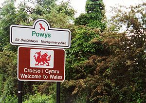
, Powys
Powys
Powys is a local-government county and preserved county in Wales.-Geography:Powys covers the historic counties of Montgomeryshire and Radnorshire, most of Brecknockshire , and a small part of Denbighshire — an area of 5,179 km², making it the largest county in Wales by land area.It is...
and Monmouthshire
Monmouthshire
Monmouthshire is a county in south east Wales. The name derives from the historic county of Monmouthshire which covered a much larger area. The largest town is Abergavenny. There are many castles in Monmouthshire .-Historic county:...
, in Wales; and Cheshire West and Chester
Cheshire West and Chester
Cheshire West and Chester is a unitary authority area with borough status, in the ceremonial county of Cheshire. It was established in April 2009 as part of the 2009 structural changes to local government in England, by virtue of an order under the Local Government and Public Involvement in Health...
, Shropshire
Shropshire Council
Shropshire Council is a unitary authority in Shropshire, United Kingdom.It replaced the former two-tier local government structure in the non-metropolitan county of Shropshire on 1 April 2009, which involved its immediate predecessor, Shropshire County Council, and five non-metropolitan districts -...
, Herefordshire
Herefordshire
Herefordshire is a historic and ceremonial county in the West Midlands region of England. For Eurostat purposes it is a NUTS 3 region and is one of three counties that comprise the "Herefordshire, Worcestershire and Gloucestershire" NUTS 2 region. It also forms a unitary district known as the...
and Forest of Dean
Forest of Dean (district)
Forest of Dean is a local government district in Gloucestershire, England, named after the Forest of Dean. Its council is based in Coleford. Other towns in the district include Cinderford, Newent and Tidenham....
district of Gloucestershire
Gloucestershire
Gloucestershire is a county in South West England. The county comprises part of the Cotswold Hills, part of the flat fertile valley of the River Severn, and the entire Forest of Dean....
, in England.
In relation to the historic counties, it passes between the historic counties of Flintshire
Flintshire (historic)
Flintshire , also known as the County of Flint, is one of thirteen historic counties, a vice-county and a former administrative county, which mostly lies on the north east coast of Wales....
, Denbighshire
Denbighshire (historic)
Historic Denbighshire is one of thirteen traditional counties in Wales, a vice-county and a former administrative county, which covers an area in north east Wales...
, Montgomeryshire
Montgomeryshire
Montgomeryshire, also known as Maldwyn is one of thirteen historic counties and a former administrative county of Wales. Montgomeryshire is still used as a vice-county for wildlife recording...
, Radnorshire
Radnorshire
Radnorshire is one of thirteen historic and former administrative counties of Wales. It is represented by the Radnorshire area of Powys, which according to the 2001 census, had a population of 24,805...
, Brecknockshire
Brecknockshire
Brecknockshire , also known as the County of Brecknock, Breconshire, or the County of Brecon is one of thirteen historic counties of Wales, and a former administrative county.-Geography:...
and Monmouthshire
Monmouthshire (historic)
Monmouthshire , also known as the County of Monmouth , is one of thirteen ancient counties of Wales and a former administrative county....
on the Welsh side; and Cheshire
Cheshire
Cheshire is a ceremonial county in North West England. Cheshire's county town is the city of Chester, although its largest town is Warrington. Other major towns include Widnes, Congleton, Crewe, Ellesmere Port, Runcorn, Macclesfield, Winsford, Northwich, and Wilmslow...
, Shropshire
Shropshire
Shropshire is a county in the West Midlands region of England. For Eurostat purposes, the county is a NUTS 3 region and is one of four counties or unitary districts that comprise the "Shropshire and Staffordshire" NUTS 2 region. It borders Wales to the west...
, Herefordshire
Herefordshire
Herefordshire is a historic and ceremonial county in the West Midlands region of England. For Eurostat purposes it is a NUTS 3 region and is one of three counties that comprise the "Herefordshire, Worcestershire and Gloucestershire" NUTS 2 region. It also forms a unitary district known as the...
and Gloucestershire
Gloucestershire
Gloucestershire is a county in South West England. The county comprises part of the Cotswold Hills, part of the flat fertile valley of the River Severn, and the entire Forest of Dean....
on the English side
Historic counties of England
The historic counties of England are subdivisions of England established for administration by the Normans and in most cases based on earlier Anglo-Saxon kingdoms and shires...
.
The border runs down the middle of Boundary Lane in Saltney
Saltney
Saltney is a small town in Flintshire, Wales. It is immediately to the west of the border with Cheshire in England and is contiguous with the Chester urban area.The name is derived from the former salt marshes on which it is built, lying on the River Dee...
dividing administrative/legislative responsibility between houses on one side of the street from the other, the only place on the border where this occurs.
History of the border
Origins
Before and during the RomanRoman Britain
Roman Britain was the part of the island of Great Britain controlled by the Roman Empire from AD 43 until ca. AD 410.The Romans referred to the imperial province as Britannia, which eventually comprised all of the island of Great Britain south of the fluid frontier with Caledonia...
occupation of Britain
Great Britain
Great Britain or Britain is an island situated to the northwest of Continental Europe. It is the ninth largest island in the world, and the largest European island, as well as the largest of the British Isles...
, all the native inhabitants of the island (other than the Pictish and Gaelic tribes of what is now modern day Scotland) spoke Brythonic languages
Brythonic languages
The Brythonic or Brittonic languages form one of the two branches of the Insular Celtic language family, the other being Goidelic. The name Brythonic was derived by Welsh Celticist John Rhys from the Welsh word Brython, meaning an indigenous Briton as opposed to an Anglo-Saxon or Gael...
, a sub-family of the Celtic languages
Celtic languages
The Celtic languages are descended from Proto-Celtic, or "Common Celtic"; a branch of the greater Indo-European language family...
, and were regarded as Britons. The clear geographical divide between the mountainous western areas of southern Britain and the generally lower-lying areas to the east was reflected in the pattern of Roman occupation. The main Roman military bases for the control of what became Wales
Roman Wales
The history of Wales in the Roman era began in AD 48 with a military invasion by the imperial governor of Roman Britain. The conquest would be completed by 78, and Roman rule would endure until the region was abandoned in 383 AD...
were beyond the mountains, at Deva
Deva Victrix
Deva Victrix, or simply Deva, was a legionary fortress and town in the Roman province of Britannia. The settlement evolved into Chester, the county town of Cheshire, England...
(Chester
Chester
Chester is a city in Cheshire, England. Lying on the River Dee, close to the border with Wales, it is home to 77,040 inhabitants, and is the largest and most populous settlement of the wider unitary authority area of Cheshire West and Chester, which had a population of 328,100 according to the...
), Viroconium
Viroconium
Viroconium Cornoviorum, or simply Viroconium , was a Roman town, one corner of which is now occupied by the small village of Wroxeter in the English county of Shropshire, about east-south-east of Shrewsbury...
(Wroxeter
Wroxeter
Wroxeter is a village in Shropshire, England. It forms part of the civil parish of Wroxeter and Uppington and is located in the Severn Valley about south-east of Shrewsbury.-History:...
, near Shrewsbury
Shrewsbury
Shrewsbury is the county town of Shropshire, in the West Midlands region of England. Lying on the River Severn, it is a civil parish home to some 70,000 inhabitants, and is the primary settlement and headquarters of Shropshire Council...
), and Isca Augusta
Isca Augusta
Isca Augusta was a Roman legionary fortress and settlement, the remains of which lie beneath parts of the present-day village of Caerleon on the northern outskirts of the city of Newport in South Wales.-Name:...
(Caerleon
Caerleon
Caerleon is a suburban village and community, situated on the River Usk in the northern outskirts of the city of Newport, South Wales. Caerleon is a site of archaeological importance, being the site of a notable Roman legionary fortress, Isca Augusta, and an Iron Age hill fort...
, near Newport
Newport
Newport is a city and unitary authority area in Wales. Standing on the banks of the River Usk, it is located about east of Cardiff and is the largest urban area within the historic county boundaries of Monmouthshire and the preserved county of Gwent...
), all located close to the later national border.
When the Roman garrison left around 410, the various parts of Britain were left to govern and defend themselves. The western area, later Wales
Wales
Wales is a country that is part of the United Kingdom and the island of Great Britain, bordered by England to its east and the Atlantic Ocean and Irish Sea to its west. It has a population of three million, and a total area of 20,779 km²...
, had become largely Christian
Christianity
Christianity is a monotheistic religion based on the life and teachings of Jesus as presented in canonical gospels and other New Testament writings...
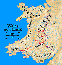
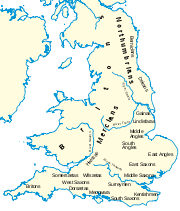
, and soon comprised a number of separate kingdoms, the largest being Gwynedd
Kingdom of Gwynedd
Gwynedd was one petty kingdom of several Welsh successor states which emerged in 5th-century post-Roman Britain in the Early Middle Ages, and later evolved into a principality during the High Middle Ages. It was based on the former Brythonic tribal lands of the Ordovices, Gangani, and the...
in the northwest and Powys in the east. Powys roughly coincided with the territory of the Celtic Cornovii
Cornovii
The Cornovii were a Celtic people of Iron Age and Roman Britain, who lived principally in the modern English counties of Cheshire, Shropshire, north Staffordshire, north Herefordshire and eastern parts of the Welsh county of Powys. Their capital in pre-Roman times was probably a hill fort on The...
tribe whose civitas or administrative centre during the Roman period was at Viroconium. Gwynedd, at the height of its power, extended as far east as the Dee estuary. Gradually, from the 5th century onwards, pagan
Paganism
Paganism is a blanket term, typically used to refer to non-Abrahamic, indigenous polytheistic religious traditions....
tribes from the east, including the Angles
Angles
The Angles is a modern English term for a Germanic people who took their name from the ancestral cultural region of Angeln, a district located in Schleswig-Holstein, Germany...
and Saxons
Saxons
The Saxons were a confederation of Germanic tribes originating on the North German plain. The Saxons earliest known area of settlement is Northern Albingia, an area approximately that of modern Holstein...
, conquered eastern and southern Britain, which later became England.
In the south, the Welsh kingdom of Gwent broadly covered the same area as the pre-Roman Silures
Silures
The Silures were a powerful and warlike tribe of ancient Britain, occupying approximately the counties of Monmouthshire, Breconshire and Glamorganshire of present day South Wales; and possibly Gloucestershire and Herefordshire of present day England...
, traditionally the area between the rivers Usk
River Usk
The River Usk rises on the northern slopes of the Black Mountain of mid-Wales, in the easternmost part of the Brecon Beacons National Park. Initially it flows north into Usk Reservoir, then east by Sennybridge to Brecon before turning southeast to flow by Talybont-on-Usk, Crickhowell and...
, Wye
River Wye
The River Wye is the fifth-longest river in the UK and for parts of its length forms part of the border between England and Wales. It is important for nature conservation and recreation.-Description:...
and the Severn estuary. It was centred at different times on Venta
Venta Silurum
Venta Silurum was a town in the Roman province of Britannia or Britain. Today it consists of remains in the village of Caerwent in Monmouthshire, south east Wales. Much of it has been archaeologically excavated and is on display to the public....
(Caerwent
Caerwent
Caerwent is a village and community in Monmouthshire, Wales. It is located about five miles west of Chepstow and eleven miles east of Newport, and was founded by the Romans as the market town of Venta Silurum, an important settlement of the Brythonic Silures tribe. The modern village is built...
), from which it derived its name, and Isca Augusta (Caerleon). Gwent generally allied with, and at various times was joined with, the smaller Welsh kingdom of Ergyng
Ergyng
Ergyng was a Welsh kingdom of the sub-Roman and early medieval period, between the 5th and 7th centuries. It was later referred to by the English as Archenfield.-Location:...
, centred in present-day southern Herefordshire west of the Wye (and deriving its name from the Roman town of Ariconium
Ariconium
Ariconium was a road station of Roman Britain mentioned in Iter XIII of the Iter Britanniarum of the Antonine Itineraries. It was located at Bury Hill in the parish of Weston under Penyard, about east of Ross on Wye, Herefordshire, and about southeast of Hereford. The site existed prior to the...
); and the larger kingdom of Glywysing in modern Glamorgan
Glamorgan
Glamorgan or Glamorganshire is one of the thirteen historic counties and a former administrative county of Wales. It was originally an early medieval kingdom of varying boundaries known as Glywysing until taken over by the Normans as a lordship. Glamorgan is latterly represented by the three...
. The name Glywysing may indicate that it was founded by a British native of Glevum
Glevum
Glevum was a Roman fort in Roman Britain that become "colonia" of retired legionaries in AD 97. Today it is known as Gloucester, located in the English county of Gloucestershire...
(Gloucester
Gloucester
Gloucester is a city, district and county town of Gloucestershire in the South West region of England. Gloucester lies close to the Welsh border, and on the River Severn, approximately north-east of Bristol, and south-southwest of Birmingham....
).
Battle of Mons Badonicus
The Battle of Mons Badonicus was a battle between a force of Britons and an Anglo-Saxon army, probably sometime between 490 and 517 AD. Though it is believed to have been a major political and military event, there is no certainty about its date, location or the details of the fighting...
, circa 500, could have been fought near Bath between the British, the victors, and Anglo-Saxons attempting to reach the Severn estuary, but its date and location are very uncertain and it may equally well have taken place in Somerset
Somerset
The ceremonial and non-metropolitan county of Somerset in South West England borders Bristol and Gloucestershire to the north, Wiltshire to the east, Dorset to the south-east, and Devon to the south-west. It is partly bounded to the north and west by the Bristol Channel and the estuary of the...
or Dorset
Dorset
Dorset , is a county in South West England on the English Channel coast. The county town is Dorchester which is situated in the south. The Hampshire towns of Bournemouth and Christchurch joined the county with the reorganisation of local government in 1974...
. However, it is more certain that the Anglo-Saxon kingdom of Wessex
Wessex
The Kingdom of Wessex or Kingdom of the West Saxons was an Anglo-Saxon kingdom of the West Saxons, in South West England, from the 6th century, until the emergence of a united English state in the 10th century, under the Wessex dynasty. It was to be an earldom after Canute the Great's conquest...
emerged in the 6th and 7th centuries in the upper Thames valley, Cotswolds
Cotswolds
The Cotswolds are a range of hills in west-central England, sometimes called the Heart of England, an area across and long. The area has been designated as the Cotswold Area of Outstanding Natural Beauty...
and Hampshire
Hampshire
Hampshire is a county on the southern coast of England in the United Kingdom. The county town of Hampshire is Winchester, a historic cathedral city that was once the capital of England. Hampshire is notable for housing the original birthplaces of the Royal Navy, British Army, and Royal Air Force...
areas. In 577, the Battle of Deorham
Battle of Deorham
The Battle of Deorham or Dyrham was fought in 577 between the West Saxons under Ceawlin and Cuthwine and the Britons of the West Country. The location, Deorham, is usually taken to refer to Dyrham in South Gloucestershire. The battle was a major victory for the West Saxons, who took three important...
in the southern Cotswolds was won by the Anglo-Saxons, and led to Wessex extending its control to the Severn estuary and the cities of Gloucester, Cirencester
Cirencester
Cirencester is a market town in east Gloucestershire, England, 93 miles west northwest of London. Cirencester lies on the River Churn, a tributary of the River Thames, and is the largest town in the Cotswold District. It is the home of the Royal Agricultural College, the oldest agricultural...
, and Bath. This severed the land link between the Britons of Wales and those of the south west peninsula
Dumnonia
Dumnonia is the Latinised name for the Brythonic kingdom in sub-Roman Britain between the late 4th and late 8th centuries, located in the farther parts of the south-west peninsula of Great Britain...
. By about 600, however, the area of modern Gloucestershire east of the Severn, as well as most of Worcestershire
Worcestershire
Worcestershire is a non-metropolitan county, established in antiquity, located in the West Midlands region of England. For Eurostat purposes it is a NUTS 3 region and is one of three counties that comprise the "Herefordshire, Worcestershire and Warwickshire" NUTS 2 region...
, was controlled by another group, the Hwicce
Hwicce
The Hwicce were one of the peoples of Anglo-Saxon England. The exact boundaries of their kingdom are uncertain, though it is likely that they coincided with those of the old Diocese of Worcester, founded in 679–80, the early bishops of which bore the title Episcopus Hwicciorum...
, who may have arisen from intermarriage between Anglo-Saxon and British leading families, possibly the successors to the pre-Roman Dobunni
Dobunni
The Dobunni were one of the Celtic tribes living in the British Isles prior to the Roman invasion of Britain. There are seven known references to the tribe in Roman histories and inscriptions. The latter part of the name possibly derives from Bune, a cup or vessel...
. The Hwicce came increasingly under Mercian hegemony.
At the Battle of Chester
Battle of Chester
The Battle of Chester was a major victory for the Anglo Saxons over the native Britons near the city of Chester, England in the early 7th century. Æthelfrith of Northumbria annihilated a combined force from the Welsh kingdoms of Powys, Rhôs and possibly Mercia...
in 616, the forces of Powys and other allied Brythonic kingdoms were defeated by the Northumbrians
Northumbria
Northumbria was a medieval kingdom of the Angles, in what is now Northern England and South-East Scotland, becoming subsequently an earldom in a united Anglo-Saxon kingdom of England. The name reflects the approximate southern limit to the kingdom's territory, the Humber Estuary.Northumbria was...
under Æthelfrith
Æthelfrith of Northumbria
Æthelfrith was King of Bernicia from c. 593 until c. 616; he was also, beginning c. 604, the first Bernician king to also rule Deira, to the south of Bernicia. Since Deira and Bernicia were the two basic components of what would later be defined as Northumbria, Æthelfrith can be considered, in...
. This divided the Britons of Wales from those in the uplands of northern England, including Lancashire
Lancashire
Lancashire is a non-metropolitan county of historic origin in the North West of England. It takes its name from the city of Lancaster, and is sometimes known as the County of Lancaster. Although Lancaster is still considered to be the county town, Lancashire County Council is based in Preston...
, Cumbria
Cumbria
Cumbria , is a non-metropolitan county in North West England. The county and Cumbria County Council, its local authority, came into existence in 1974 after the passage of the Local Government Act 1972. Cumbria's largest settlement and county town is Carlisle. It consists of six districts, and in...
, and south west Scotland
Southern Uplands
The Southern Uplands are the southernmost and least populous of mainland Scotland's three major geographic areas . The term is used both to describe the geographical region and to collectively denote the various ranges of hills within this region...
, an area which became known as "Yr Hen Ogledd
Hen Ogledd
Yr Hen Ogledd is a Welsh term used by scholars to refer to those parts of what is now northern England and southern Scotland in the years between 500 and the Viking invasions of c. 800, with particular interest in the Brythonic-speaking peoples who lived there.The term is derived from heroic...
" or "the Old North". Within a few decades, the Welsh became engaged in further defensive warfare against the increasingly powerful kingdom of Mercia
Mercia
Mercia was one of the kingdoms of the Anglo-Saxon Heptarchy. It was centred on the valley of the River Trent and its tributaries in the region now known as the English Midlands...
, based at Tamworth
Tamworth
Tamworth is a town and local government district in Staffordshire, England, located north-east of Birmingham city centre and north-west of London. The town takes its name from the River Tame, which flows through the town, as does the River Anker...
in what became the West Midlands
West Midlands (region)
The West Midlands is an official region of England, covering the western half of the area traditionally known as the Midlands. It contains the second most populous British city, Birmingham, and the larger West Midlands conurbation, which includes the city of Wolverhampton and large towns of Dudley,...
of England. The capital of Powys, Pengwern
Pengwern
Pengwern was a Brythonic settlement of sub-Roman Britain situated in what is now the English county of Shropshire, adjoining the modern Welsh border. It is generally regarded as being the early seat of the kings of Powys before its establishment at Mathrafal, further west, but the theory that it...
, at or near modern Shrewsbury, was conquered by Oswiu of Northumbria
Oswiu of Northumbria
Oswiu , also known as Oswy or Oswig , was a King of Bernicia. His father, Æthelfrith of Bernicia, was killed in battle, fighting against Rædwald, King of the East Angles and Edwin of Deira at the River Idle in 616...
in 656 when he had become overlord of the Mercians. Powys then withdrew from the lowland areas now in southern Cheshire
Cheshire
Cheshire is a ceremonial county in North West England. Cheshire's county town is the city of Chester, although its largest town is Warrington. Other major towns include Widnes, Congleton, Crewe, Ellesmere Port, Runcorn, Macclesfield, Winsford, Northwich, and Wilmslow...
, Shropshire
Shropshire
Shropshire is a county in the West Midlands region of England. For Eurostat purposes, the county is a NUTS 3 region and is one of four counties or unitary districts that comprise the "Shropshire and Staffordshire" NUTS 2 region. It borders Wales to the west...
and Herefordshire
Herefordshire
Herefordshire is a historic and ceremonial county in the West Midlands region of England. For Eurostat purposes it is a NUTS 3 region and is one of three counties that comprise the "Herefordshire, Worcestershire and Gloucestershire" NUTS 2 region. It also forms a unitary district known as the...
, which became known to Welsh poets as "The Paradise of Powys". The areas were occupied by Anglo-Saxon groups who became sub-kingdoms of Mercia, the Wreocensǣte or Wrekinset
Wrekinset
The Wreocensæte , sometimes anglicized as the Wrekinsets, were one of the peoples of Anglo-Saxon Britain. Their name approximates to "Wrekin-dwellers". It is also suggested that Wrexham also derived from Wreocensæte...
in the northern part of what became Shropshire
Shropshire
Shropshire is a county in the West Midlands region of England. For Eurostat purposes, the county is a NUTS 3 region and is one of four counties or unitary districts that comprise the "Shropshire and Staffordshire" NUTS 2 region. It borders Wales to the west...
, and the Magonsæte in the southern part. Further south, the area north west of the Severn later known as the Forest of Dean
Forest of Dean
The Forest of Dean is a geographical, historical and cultural region in the western part of the county of Gloucestershire, England. The forest is a roughly triangular plateau bounded by the River Wye to the west and north, the River Severn to the south, and the City of Gloucester to the east.The...
seems to have remained in British (that is, Welsh) hands until about 760.
Offa's Dyke
After Ine of Wessex
Ine of Wessex
Ine was King of Wessex from 688 to 726. He was unable to retain the territorial gains of his predecessor, Cædwalla, who had brought much of southern England under his control and expanded West Saxon territory substantially...
abdicated in 726, Æthelbald of Mercia established Mercia's hegemony over the Anglo-Saxons south of the Humber
Humber
The Humber is a large tidal estuary on the east coast of Northern England. It is formed at Trent Falls, Faxfleet, by the confluence of the tidal River Ouse and the tidal River Trent. From here to the North Sea, it forms part of the boundary between the East Riding of Yorkshire on the north bank...
. However, campaigns by Powys against Mercia led to the building of Wat's Dyke
Wat's Dyke
Wat's Dyke is a 40 mile earthwork running through the northern Welsh Marches from Basingwerk Abbey on the River Dee estuary, passing to the east of Oswestry and onto Maesbury in Shropshire, England...
, an earthwork boundary extending from the Severn
River Severn
The River Severn is the longest river in Great Britain, at about , but the second longest on the British Isles, behind the River Shannon. It rises at an altitude of on Plynlimon, Ceredigion near Llanidloes, Powys, in the Cambrian Mountains of mid Wales...
valley near Oswestry to the Dee at Basingwerk in what became Flintshire
Flintshire (historic)
Flintshire , also known as the County of Flint, is one of thirteen historic counties, a vice-county and a former administrative county, which mostly lies on the north east coast of Wales....
, perhaps to protect recently acquired lands. After Æthelbald was killed in 757, a brief civil war in Mercia then ended in victory for his distant cousin, Offa
Offa of Mercia
Offa was the King of Mercia from 757 until his death in July 796. The son of Thingfrith and a descendant of Eowa, Offa came to the throne after a period of civil war following the assassination of Æthelbald after defeating the other claimant Beornred. In the early years of Offa's reign it is likely...
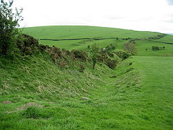
. As king, he rebuilt Mercia's hegemony over the southern English through military campaigns, and also caused the construction of Offa's Dyke, around the years 770/780.
Offa's Dyke
Offa's Dyke
Offa's Dyke is a massive linear earthwork, roughly followed by some of the current border between England and Wales. In places, it is up to wide and high. In the 8th century it formed some kind of delineation between the Anglian kingdom of Mercia and the Welsh kingdom of Powys...
is a massive linear earthwork, up to 65 feet (20 m) wide (including its surrounding ditch) and 8 feet (2.5 m) high. It is much larger and longer than Wat's Dyke, but runs roughly parallel to it. The earthwork was generally dug with the displaced soil piled into a bank on the Mercian (eastern) side, providing an open view into Wales and suggesting that it was built by Mercia to guard against attacks or raids from Powys. The late 9th-century writer Asser
Asser
Asser was a Welsh monk from St David's, Dyfed, who became Bishop of Sherborne in the 890s. About 885 he was asked by Alfred the Great to leave St David's and join the circle of learned men whom Alfred was recruiting for his court...
wrote that Offa "terrified all the neighbouring kings and provinces around him, and ... had a great dyke built between Wales and Mercia from sea to sea". In the mid-20th century, Sir Cyril Fox
Cyril Fox
Sir Cyril Fred Fox , born, Chippenham, Wiltshire, was an English archaeologist.Cyril Fox became keeper of archaeology at the National Museum of Wales...
completed a major survey of the Dyke and stated that it ran from the Dee to the Severn, as Asser suggested, but with gaps, especially in the Herefordshire area, where natural barriers of strong rivers or dense forests provided sufficient defence. More recent research by David Hill and Margaret Worthington concluded that there is little evidence for the Dyke stretching "from sea to sea", but that the earthwork built by Offa stretched some 64 miles (103 km) between Rushock Hill near Kington
Kington, Herefordshire
Kington is a market town and civil parish in Herefordshire, England. According to the 2001 census it had a population of 2,597.-Location:Kington is near the Wales-England border and, despite being on the western side of Offa's Dyke, has been English for over a thousand years. The town is in the...
in Herefordshire, and Treuddyn
Treuddyn
Treuddyn is a small village and community in Flintshire, Wales, located just off the A5104 road, around 4 miles south-east of Mold and 3 miles north-west of Caergwrle. The community includes the nearby village of Coed Talon, to the east, and Rhydtalog, to the south-west on the Denbighshire border...
in Flintshire. Earthworks in the far north and south, including sections overlooking the Wye valley
Wye Valley
The Wye Valley Area of Outstanding Natural Beauty is an internationally important protected landscape straddling the border between England and Wales. It is one of the most dramatic and scenic landscape areas in southern Britain....
and east of the Wye at Beachley
Beachley
Beachley is a village in Gloucestershire, England, near the border with Wales. It is located on a peninsula at the junction between the Rivers Wye and Severn, where the Severn Bridge ends and the smaller secondary bridge for the River Wye begins. The tidal drop here is one of the highest in the UK...
, may in their view have been built for different purposes at different times, although their conclusions are themselves disputed.
Offa's Dyke largely remained the frontier between the Welsh and English in later centuries. By the 9th century, the expanding power of Mercia led to it gaining control over Ergyng and nearby Hereford
Hereford
Hereford is a cathedral city, civil parish and county town of Herefordshire, England. It lies on the River Wye, approximately east of the border with Wales, southwest of Worcester, and northwest of Gloucester...
. The system of shires which was later to form the basis of local administration throughout England and eventually Wales originated in Wessex, where it became established during the 8th century. Wessex and Mercia gradually established an occasionally unstable alliance, with Wessex gaining the upper hand. According to Asser, the southern Welsh kings, including Hywel ap Rhys of Glywysing, commended themselves to Alfred the Great
Alfred the Great
Alfred the Great was King of Wessex from 871 to 899.Alfred is noted for his defence of the Anglo-Saxon kingdoms of southern England against the Vikings, becoming the only English monarch still to be accorded the epithet "the Great". Alfred was the first King of the West Saxons to style himself...
of Wessex in about 885. Alfred's son Edward the Elder
Edward the Elder
Edward the Elder was an English king. He became king in 899 upon the death of his father, Alfred the Great. His court was at Winchester, previously the capital of Wessex...
also secured homage from the Welsh, although sporadic border unrest continued. In the early 10th century, a document known as The Ordinance Concerning the Dunsaete records procedures for dealing with disputes between the English and the Welsh, and implies that areas west of the Wye in Archenfield
Archenfield
Archenfield is the historic English name for an area of southern and western Herefordshire in England. Since the Anglo-Saxons took over the region in the 8th century, it has stretched between the River Monnow and River Wye, but it derives from the once much larger Welsh kingdom of...
were still culturally Welsh. It stated that the English should only cross into the Welsh side, and vice versa, in the presence of an appointed man who had the responsibility of making sure that the foreigner was safely escorted back to the crossing point. In 926, Edward's successor Athelstan
Athelstan of England
Athelstan , called the Glorious, was the King of England from 924 or 925 to 939. He was the son of King Edward the Elder, grandson of Alfred the Great and nephew of Æthelflæd of Mercia...
, "King of the English", summoned the Welsh kings including Hywel Dda
Hywel Dda
Hywel Dda , was the well-thought-of king of Deheubarth in south-west Wales, who eventually came to rule Wales from Prestatyn to Pembroke. As a descendant of Rhodri Mawr, through his father Cadell, Hywel was a member of the Dinefwr branch of the dynasty and is also named Hywel ap Cadell...
of Deheubarth to a meeting at Hereford, and according to William of Malmesbury
William of Malmesbury
William of Malmesbury was the foremost English historian of the 12th century. C. Warren Hollister so ranks him among the most talented generation of writers of history since Bede, "a gifted historical scholar and an omnivorous reader, impressively well versed in the literature of classical,...
laid down the boundary between Wales and England, particularly the disputed southern stretch where he specified that the eastern bank of the Wye should form the boundary.
By the mid-eleventh century, most of Wales had become united under the king of Gwynedd
Gwynedd
Gwynedd is a county in north-west Wales, named after the old Kingdom of Gwynedd. Although the second biggest in terms of geographical area, it is also one of the most sparsely populated...
, Gruffudd ap Llywelyn. In 1055 he marched on Hereford and sacked the city. He also seized Morgannwg and Gwent, together with substantial territories east of Offa's Dyke, and raided as far as Chester and Leominster
Leominster
Leominster is a market town in Herefordshire, England, located approximately north of the city of Hereford and south of Ludlow, at...
. He claimed sovereignty over the whole of Wales, a claim recognised by the English, and historian John Davies
John Davies (historian)
John Davies is a Welsh historian, and a television and radio broadcaster.Davies was born in the Rhondda, Wales, and studied at both University College, Cardiff, and Trinity College, Cambridge. He is married with four children...
states that Gruffudd was "the only Welsh king ever to rule over the entire territory of Wales." However, his murder in 1063 left a power vacuum, and Harold Godwinson
Harold Godwinson
Harold Godwinson was the last Anglo-Saxon King of England.It could be argued that Edgar the Atheling, who was proclaimed as king by the witan but never crowned, was really the last Anglo-Saxon king...
, Earl of Hereford
Earl of Hereford
The title of Earl of Hereford was created six times in the Peerage of England. See also Duke of Hereford, Viscount Hereford. Dates indicate the years the person held the title for.-Earls of Hereford, First Creation :*Swegen Godwinson...
, and his brother Tostig, began a campaign of subjugation in Wales which continued until Harold was defeated at the Battle of Hastings
Battle of Hastings
The Battle of Hastings occurred on 14 October 1066 during the Norman conquest of England, between the Norman-French army of Duke William II of Normandy and the English army under King Harold II...
in 1066.
The March of Wales
Norman conquest of England
The Norman conquest of England began on 28 September 1066 with the invasion of England by William, Duke of Normandy. William became known as William the Conqueror after his victory at the Battle of Hastings on 14 October 1066, defeating King Harold II of England...
, King William
William I of England
William I , also known as William the Conqueror , was the first Norman King of England from Christmas 1066 until his death. He was also Duke of Normandy from 3 July 1035 until his death, under the name William II...
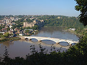
installed one of his most trusted confidants, William FitzOsbern, as Earl of Hereford. By 1071 he had started the building of Chepstow Castle
Chepstow Castle
Chepstow Castle , located in Chepstow, Monmouthshire in Wales, on top of cliffs overlooking the River Wye, is the oldest surviving post-Roman stone fortification in Britain...
, the first castle in Britain built of stone, near the mouth of the Wye. It served as a base from which the Normans continued to expand westward into south Wales
South Wales
South Wales is an area of Wales bordered by England and the Bristol Channel to the east and south, and Mid Wales and West Wales to the north and west. The most densely populated region in the south-west of the United Kingdom, it is home to around 2.1 million people and includes the capital city of...
, establishing a castle at Caerleon and extinguishing the Welsh kingdom of Gwent. William also installed Roger de Montgomerie at Shrewsbury, and Hugh d'Avranches at Chester, creating a new expansionist earldom in each case. In the Domesday Book
Domesday Book
Domesday Book , now held at The National Archives, Kew, Richmond upon Thames in South West London, is the record of the great survey of much of England and parts of Wales completed in 1086...
of 1086, Norman lands are recorded west of the Wye at Chepstow and Caldicot
Caldicot, Monmouthshire
Caldicot is a small town in Monmouthshire, southeast Wales, located between Chepstow and Newport, just off the busy M4 / M48 motorway corridor. The site adjoins the Caldicot Levels, on the north side of the Severn estuary. Caldicot has easy access by motorway and rail to Cardiff, and across the...
in the Gwent Levels ; over the whole of north east Wales as far west as the River Clwyd
River Clwyd
The River Clwyd is a river in North Wales which rises in the Clocaenog Forest northwest of Corwen.It flows due south until at Melin-y-Wig it veers northeastwards, tracking the A494 to Ruthin. Here it leaves the relatively narrow valley and enters a broad agricultural vale, the Vale of Clwyd...
, an area known to the Welsh as the Perfeddwlad
Perfeddwlad
Perfeddwlad, , , was a name adopted during the twelfth century for the territories in north-east Wales lying between the rivers Conwy and Dee, and comprised the cantrefi of Rhos, Rhufoniog, Dyffryn Clwyd and Tegeingl...
; and west of Offa's Dyke, especially in Powys where a new castle was named, after its lord, Montgomery.
Domesday Book
Domesday Book
Domesday Book , now held at The National Archives, Kew, Richmond upon Thames in South West London, is the record of the great survey of much of England and parts of Wales completed in 1086...
no doubt records the extent of English penetration into Wales. This suggests that Offa's Dyke still approximately represented the boundary between England and Wales. However, during the anarchy of Stephen
The Anarchy
The Anarchy or The Nineteen-Year Winter was a period of English history during the reign of King Stephen, which was characterised by civil war and unsettled government...
various Welsh princes were able to occupy lands beyond it, including Whittington, Shropshire
Whittington, Shropshire
Whittington is a village in north west Shropshire, England.The civil parish of Whittington has a population of 2,490 as of the 2001 census. The village of Whittington is in the centre of the parish, and two smaller villages, Hindford to the north-east and Babbinswood to the south, are also within...
(see Whittington Castle
Whittington Castle
Whittington Castle is a castle in northern Shropshire, England, owned and managed by the Whittington Castle Preservation Fund. The castle was originally a motte-and-bailey castle, but this was replaced in the 13th century by one with buildings around a courtyard whose exterior wall was the curtain...
) and Maelor Saesnaeg
Maelor
Maelor is a border area of north-east Wales. It originated as a Cantref of the Kingdom of Powys, focused on Bangor-on-Dee.-History:The Maelor was first divided from the rest of Wales by the construction of Offa's Dyke in the eighth century, but was reclaimed for Wales during the reign of Stephen...
, hitherto in England. These lands were brought under English lordship by Henry II of England
Henry II of England
Henry II ruled as King of England , Count of Anjou, Count of Maine, Duke of Normandy, Duke of Aquitaine, Duke of Gascony, Count of Nantes, Lord of Ireland and, at various times, controlled parts of Wales, Scotland and western France. Henry, the great-grandson of William the Conqueror, was the...
, but became Marcher lordships, and so part of Wales. This involved a loss of direct rule by the English crown.
Over the next four centuries, Norman lords established mostly small lordships, at times numbering over 150, between the Dee and Severn and further west. The precise dates and means of formation of the lordships varied, as did their size. Hundreds of small castles, mostly of the motte and bailey type, were built in the border area in the 12th and 13th centuries, predominantly by Norman lords as assertions of power as well as defences against Welsh raiders and rebels. Many new towns were established across the area, some such as Chepstow, Monmouth
Monmouth
Monmouth is a town in southeast Wales and traditional county town of the historic county of Monmouthshire. It is situated close to the border with England, where the River Monnow meets the River Wye with bridges over both....
, Ludlow
Ludlow
Ludlow is a market town in Shropshire, England close to the Welsh border and in the Welsh Marches. It lies within a bend of the River Teme, on its eastern bank, forming an area of and centred on a small hill. Atop this hill is the site of Ludlow Castle and the market place...
and Newtown becoming successful trading centres, and these tended to be a focus of English settlement. However, the Welsh continued to attack English soil and supported rebellions against the Normans.
Welsh Marches
The Welsh Marches is a term which, in modern usage, denotes an imprecisely defined area along and around the border between England and Wales in the United Kingdom. The precise meaning of the term has varied at different periods...
, or Marchia Wallia, were to a greater or lesser extent independent of both the English monarchy and the Principality of Wales
Principality of Wales
The Principality of Wales existed between 1216 and 1542, encompassing two-thirds of modern Wales.It was formally founded in 1216 at the Council of Aberdyfi, and later recognised by the 1218 Treaty of Worcester between Llywelyn the Great of Wales and Henry III of England...
, which remained based in Gwynedd in the north west of the country. By the early 12th century, they covered the areas which would later become Monmouthshire
Monmouthshire (historic)
Monmouthshire , also known as the County of Monmouth , is one of thirteen ancient counties of Wales and a former administrative county....
and much of Flintshire
Flintshire
Flintshire is a county in north-east Wales. It borders Denbighshire, Wrexham and the English county of Cheshire. It is named after the historic county of Flintshire, which had notably different borders...
, Montgomeryshire
Montgomeryshire
Montgomeryshire, also known as Maldwyn is one of thirteen historic counties and a former administrative county of Wales. Montgomeryshire is still used as a vice-county for wildlife recording...
, Radnorshire
Radnorshire
Radnorshire is one of thirteen historic and former administrative counties of Wales. It is represented by the Radnorshire area of Powys, which according to the 2001 census, had a population of 24,805...
, Brecknockshire
Brecknockshire
Brecknockshire , also known as the County of Brecknock, Breconshire, or the County of Brecon is one of thirteen historic counties of Wales, and a former administrative county.-Geography:...
, Glamorgan
Glamorgan
Glamorgan or Glamorganshire is one of the thirteen historic counties and a former administrative county of Wales. It was originally an early medieval kingdom of varying boundaries known as Glywysing until taken over by the Normans as a lordship. Glamorgan is latterly represented by the three...
, Carmarthenshire
Carmarthenshire
Carmarthenshire is a unitary authority in the south west of Wales and one of thirteen historic counties. It is the 3rd largest in Wales. Its three largest towns are Llanelli, Carmarthen and Ammanford...
and Pembrokeshire
Pembrokeshire
Pembrokeshire is a county in the south west of Wales. It borders Carmarthenshire to the east and Ceredigion to the north east. The county town is Haverfordwest where Pembrokeshire County Council is headquartered....
. Some of the lordships, such as Oswestry, Whittington
Whittington Castle
Whittington Castle is a castle in northern Shropshire, England, owned and managed by the Whittington Castle Preservation Fund. The castle was originally a motte-and-bailey castle, but this was replaced in the 13th century by one with buildings around a courtyard whose exterior wall was the curtain...
, Clun
Clun
Clun is a small town in Shropshire, England. The town is located entirely in the Shropshire Hills Area of Outstanding Natural Beauty. The 2001 census recorded 642 people living in the town...
, and Wigmore had been part of England at the time of Domesday, while others such as the Lordship of Powys
Powys Wenwynwyn
Powys Wenwynwyn or Powys Cyfeiliog was the southern portion of the former princely state of Powys which split following the death of Madog ap Maredudd of Powys in 1160...
were Welsh principalities that passed by marriage into the hands of Norman barons. In ecclesiastical terms, the ancient diocese
Diocese
A diocese is the district or see under the supervision of a bishop. It is divided into parishes.An archdiocese is more significant than a diocese. An archdiocese is presided over by an archbishop whose see may have or had importance due to size or historical significance...
s of Bangor
Bishop of Bangor
The Bishop of Bangor is the Ordinary of the Church in Wales Diocese of Bangor.The diocese covers the counties of Anglesey, most of Caernarfonshire and Merionethshire and a small part of Montgomeryshire...
and St. Asaph
Diocese of St Asaph
The Diocese of Saint Asaph is a diocese in north-east Wales, named after Saint Asaph, its second bishop.-Geography:The Anglican Diocese of St Asaph in the north-east corner of Wales stretches from the borders of Chester in the east, to the Conwy valley in the west, to Bala in the south-west, and...
in the north, and St. David's and Llandaff
Diocese of Llandaff
The Diocese of Llandaff is a Church in Wales diocese. It is headed by the Bishop of Llandaff, whose seat is located at the Cathedral Church of Saint Peter and Saint Paul in Llandaff, a suburb of Cardiff...
in the south, collectively defined an area which included both the Principality and the March, and coincided closely with later definitions of Wales.
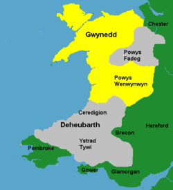
The Principality of Wales
Principality of Wales
The Principality of Wales existed between 1216 and 1542, encompassing two-thirds of modern Wales.It was formally founded in 1216 at the Council of Aberdyfi, and later recognised by the 1218 Treaty of Worcester between Llywelyn the Great of Wales and Henry III of England...
covered the lands ruled by the Prince of Wales
Prince of Wales
Prince of Wales is a title traditionally granted to the heir apparent to the reigning monarch of the United Kingdom of Great Britain and Northern Ireland and the 15 other independent Commonwealth realms...
directly, and was formally founded in 1216, and later recognised by the 1218 Treaty of Worcester between Llywelyn ab Iorwerth, Prince of Gwynedd
Kingdom of Gwynedd
Gwynedd was one petty kingdom of several Welsh successor states which emerged in 5th-century post-Roman Britain in the Early Middle Ages, and later evolved into a principality during the High Middle Ages. It was based on the former Brythonic tribal lands of the Ordovices, Gangani, and the...
, and King John of England
John of England
John , also known as John Lackland , was King of England from 6 April 1199 until his death...
. Encompassing two-thirds of modern Wales, the principality operated as an effectively independent entity from the reign of Llywelyn until 1283 (though it underwent a period of contraction during the early part of the reign of Dafydd ap Llywelyn
Dafydd ap Llywelyn
Dafydd ap Llywelyn was Prince of Gwynedd from 1240 to 1246. He was for a time recognised as Prince of Wales.- Descent :...
in the 1240s, and again for several years from the beginning of Llywelyn ap Gruffudd's rule in 1246). Its independence was characterized by a separate legal jurisprudence based on the well established laws of Cyfraith Hywel
Welsh law
Welsh law was the system of law practised in Wales before the 16th century. According to tradition it was first codified by Hywel Dda during the period between 942 and 950 when he was king of most of Wales; as such it is usually called Cyfraith Hywel, the Law of Hywel, in Welsh...
, and by the increasingly sophisticated court
Curia Regis
Curia regis is a Latin term meaning "royal council" or "king's court."- England :The Curia Regis, in the Kingdom of England, was a council of tenants-in-chief and ecclesiastics that advised the king of England on legislative matters...
of the Aberffraw
Aberffraw
Aberffraw is a small village and community on the south west coast of the Isle of Anglesey , in Wales, by the west bank of the River Ffraw, at . The UK postcode begins LL63. Access by road is by way of the A4080 and the nearest rail station is Bodorgan. In the early Middle Ages Aberffraw was the...
dynasty.
The Statute of Rhuddlan
Statute of Rhuddlan
The Statute of Rhuddlan , also known as the Statutes of Wales or as the Statute of Wales provided the constitutional basis for the government of the Principality of North Wales from 1284 until 1536...
in 1284 followed the conquest of the Principality by Edward I of England
Edward I of England
Edward I , also known as Edward Longshanks and the Hammer of the Scots, was King of England from 1272 to 1307. The first son of Henry III, Edward was involved early in the political intrigues of his father's reign, which included an outright rebellion by the English barons...
. It assumed the lands held by the Princes of Gwynedd under the title "Prince of Wales
Prince of Wales
Prince of Wales is a title traditionally granted to the heir apparent to the reigning monarch of the United Kingdom of Great Britain and Northern Ireland and the 15 other independent Commonwealth realms...
" as legally part of the lands of England, and established shire counties on the English model over those areas. The Council of Wales, based at Ludlow Castle
Ludlow Castle
Ludlow Castle is a large, partly ruined, non-inhabited castle which dominates the town of Ludlow in Shropshire, England. It stands on a high point overlooking the River Teme...
, was also established in the 15th century to govern the area.
The formation of "England and Wales" and the county boundaries
However, the Marches remained outside the shire system, and at least nominally outside the control of the English monarchy, until the first Laws in Wales Act was introduced in 1535 under Henry VIIIHenry VIII of England
Henry VIII was King of England from 21 April 1509 until his death. He was Lord, and later King, of Ireland, as well as continuing the nominal claim by the English monarchs to the Kingdom of France...
. This, and a further Act in 1542, had the effect of annexing Wales to England
Kingdom of England
The Kingdom of England was, from 927 to 1707, a sovereign state to the northwest of continental Europe. At its height, the Kingdom of England spanned the southern two-thirds of the island of Great Britain and several smaller outlying islands; what today comprises the legal jurisdiction of England...
and creating a single state and legal jurisdiction
Jurisdiction
Jurisdiction is the practical authority granted to a formally constituted legal body or to a political leader to deal with and make pronouncements on legal matters and, by implication, to administer justice within a defined area of responsibility...
, commonly referred to as England and Wales
England and Wales
England and Wales is a jurisdiction within the United Kingdom. It consists of England and Wales, two of the four countries of the United Kingdom...
. The powers of the marcher lordships were abolished, and their areas formed into new counties, or amalgamated into existing ones.
At this point, the boundary between England and Wales, which has existed ever since, was effectively fixed. In the border areas, five new counties were created - Denbighshire, Montgomeryshire, Radnorshire, Brecknockshire and Monmouthshire - and Flintshire gained some additional territory. However, several of the marcher lordships were incorporated in whole or in part into English counties. The lordships of Ludlow, Clun, Caus
Caus Castle
Caus Castle is a hill fort and medieval castle in the civil parish of Westbury in the English county of Shropshire. It is situated up on the eastern foothills of the Long Mountain guarding the route from Shrewsbury, Shropshire to Montgomery, Powys on the border between England and Wales.- History...
and part of Montgomery were incorporated into Shropshire; and Wigmore, Huntington
Huntington, Herefordshire
-History:Huntington was a Medieval borough founded as a replacement to nearby Kington which had been destroyed in 1216.Huntington was built as a new borough and was apparently in the first breath of life in 1228 when it was first mentioned...
, Clifford
Clifford, Herefordshire
Clifford is a village and civil parish in Herefordshire, England, four miles to the north of Hay-on-Wye. It lies on the south bank of the River Wye, which here forms the border between Wales and England....
and most of Ewyas
Ewyas
Ewyas was a possible early Welsh kingdom which may have been formed around the time of the Roman withdrawal from Britain in the 5th century. The name was later used for a much smaller commote or administrative sub-division, which covered the area of the modern Vale of Ewyas and a larger area to...
were included in Herefordshire. According to John Davies:
Thus was created the border between Wales and England, a border which has survived until today. It did not follow the old line of Offa's Dyke nor the eastern boundary of the Welsh dioceses; it excluded districts such as Oswestry and Ewias, where the Welsh language would continue to be spoken for centuries, districts which it would not be wholly fanciful to consider as Cambria irredenta. Yet, as the purpose of the statute was to incorporate Wales into England, the location of the Welsh border was irrelevant to the purposes of its framers.
An 1844 Act of Parliament later abolished several enclaves. One of these, Welsh Bicknor
Welsh Bicknor
Welsh Bicknor is an area of Herefordshire, England. Despite its name, it is not currently in Wales, but was historically a detached parish of the county of Monmouthshire....
, was an exclave of Monmouthshire between Gloucestershire and Herefordshire.
Monmouthshire
Although Monmouthshire was included in the 16th century legislation, it was treated anomalously, with the result that its legal status as a Welsh county fell into some ambiguity and doubt until the 20th century. It was omitted from the second Act of Union, which established the Court of Great SessionsCourt of Great Sessions in Wales
The Court of Great Sessions in Wales was the main court for the prosecution of felonies and serious misdemeanours in Wales between the second Laws in Wales Act of 1542 and the court's abolition in 1830....
, and like English shires it was given two Knights of the Shire
Knights of the Shire
From the creation of the Parliament of England in mediaeval times until 1826 each county of England and Wales sent two Knights of the Shire as members of Parliament to represent the interests of the county, when the number of knights from Yorkshire was increased to four...
, rather than one as elsewhere in Wales. However, in ecclesiastical terms, almost all of the county remained within the Diocese of Llandaff
Diocese of Llandaff
The Diocese of Llandaff is a Church in Wales diocese. It is headed by the Bishop of Llandaff, whose seat is located at the Cathedral Church of Saint Peter and Saint Paul in Llandaff, a suburb of Cardiff...
, and most of its residents at the time spoke Welsh
Welsh language
Welsh is a member of the Brythonic branch of the Celtic languages spoken natively in Wales, by some along the Welsh border in England, and in Y Wladfa...
. In the late 17th century under Charles II
Charles II of England
Charles II was monarch of the three kingdoms of England, Scotland, and Ireland.Charles II's father, King Charles I, was executed at Whitehall on 30 January 1649, at the climax of the English Civil War...
it was added to the Oxford circuit of the English Assizes, following which, according to the 1911 Encyclopædia Britannica, it gradually "came to be regarded as an English county". Under that interpretation, the boundary between England and Wales passed down the Rhymney valley
Rhymney River
The Rhymney River is a river in the Rhymney Valley, south-east Wales, flowing through Cardiff into the Severn estuary.The river forms the boundary between the historic counties of Glamorgan and Monmouthshire.-Path of the river:...
, along Monmouthshire's western borders with Brecknockshire and Glamorgan, so including Newport
Newport
Newport is a city and unitary authority area in Wales. Standing on the banks of the River Usk, it is located about east of Cardiff and is the largest urban area within the historic county boundaries of Monmouthshire and the preserved county of Gwent...
, and other industrialised parts of what would now generally be considered to be South Wales
South Wales
South Wales is an area of Wales bordered by England and the Bristol Channel to the east and south, and Mid Wales and West Wales to the north and west. The most densely populated region in the south-west of the United Kingdom, it is home to around 2.1 million people and includes the capital city of...
, within England.
The 1911 Encyclopædia Britannica unambiguously described the county as part of England, but noted that "whenever an act [...] is intended to apply to [Wales] alone, then Wales is always coupled with Monmouthshire". Some legislation and UK government decisions, such as the establishment of a "Royal Commission on Ancient and Historical Monuments in Wales and Monmouthshire" in 1908, referred to "Wales and Monmouthshire", so that it was treated as one with Wales rather than as a legal part of Wales. The county's status continued to be a matter of debate in Parliament, especially as Welsh nationalism and devolution climbed the political agenda in the 20th century. In 1921 the area was included within the Church in Wales
Church in Wales
The Church in Wales is the Anglican church in Wales, composed of six dioceses.As with the primus of the Scottish Episcopal Church, the Archbishop of Wales serves concurrently as one of the six diocesan bishops. The current archbishop is Barry Morgan, the Bishop of Llandaff.In contrast to the...
. The Welsh Office
Welsh Office
The Welsh Office was a department in the Government of the United Kingdom with responsibilities for Wales. It was established in April 1965 to execute government policy in Wales, and was headed by the Secretary of State for Wales, a post which had been created in October 1964...
, established in 1966, included Monmouthshire within its remit, and in 1969 George Thomas
George Thomas, 1st Viscount Tonypandy
Thomas George Thomas, 1st Viscount Tonypandy PC was a British Labour Party politician and Speaker of the House of Commons. Born in Port Talbot, Wales, he initially worked as a teacher in both London and Cardiff...
, Secretary of State for Wales
Secretary of State for Wales
The Secretary of State for Wales is the head of the Wales Office within the British cabinet. He or she is responsible for ensuring Welsh interests are taken into account by the government, representing the government within Wales and overseeing the passing of legislation which is only for Wales...
, proposed to fully incorporate Monmouthshire into Wales. The issue was finally clarified in law by the Local Government Act 1972
Local Government Act 1972
The Local Government Act 1972 is an Act of Parliament in the United Kingdom that reformed local government in England and Wales on 1 April 1974....
, which provided that "in every act passed on or after 1 April 1974, and in every instrument made on or after that date under any enactment (whether before, on or after that date) "Wales", subject to any alterations of boundaries..." included "the administrative county of Monmouthshire and the county borough of Newport". The national boundary between Wales and England therefore now passes unequivocally along Monmouthshire's eastern boundaries with the English counties of Herefordshire
Herefordshire
Herefordshire is a historic and ceremonial county in the West Midlands region of England. For Eurostat purposes it is a NUTS 3 region and is one of three counties that comprise the "Herefordshire, Worcestershire and Gloucestershire" NUTS 2 region. It also forms a unitary district known as the...
and Gloucestershire
Gloucestershire
Gloucestershire is a county in South West England. The county comprises part of the Cotswold Hills, part of the flat fertile valley of the River Severn, and the entire Forest of Dean....
, essentially along the River Monnow
River Monnow
The River Monnow flows through south-west Herefordshire, England and eastern Monmouthshire, Wales.- Border River :For much of its short length it marks the border between England and Wales before it joins the River Wye at Monmouth. The Wye is also half English from Monmouth until it meets the...
and River Wye
River Wye
The River Wye is the fifth-longest river in the UK and for parts of its length forms part of the border between England and Wales. It is important for nature conservation and recreation.-Description:...
.
The border today
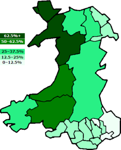
Sunday Closing (Wales) Act 1881
The Sunday Closing Act 1881 was an Act of the Parliament of the United Kingdom. It required the closure of all public houses in Wales on Sundays. The Act had considerable political importance as a formal acknowledgement of the separate character of Wales, setting a precedent for future...
since the 16th century was passed in 1881, the border between Wales and England has taken on increasing legal and political significance. In 1964 a separate department of state was established for Wales - the Welsh Office
Welsh Office
The Welsh Office was a department in the Government of the United Kingdom with responsibilities for Wales. It was established in April 1965 to execute government policy in Wales, and was headed by the Secretary of State for Wales, a post which had been created in October 1964...
- which assumed an increasing range of administrative responsibilities from Whitehall
Whitehall
Whitehall is a road in Westminster, in London, England. It is the main artery running north from Parliament Square, towards Charing Cross at the southern end of Trafalgar Square...
. By 1992, the Welsh Office oversaw housing
Public housing
Public housing is a form of housing tenure in which the property is owned by a government authority, which may be central or local. Social housing is an umbrella term referring to rental housing which may be owned and managed by the state, by non-profit organizations, or by a combination of the...
, local government, roads, historic buildings, health, education, economic development
Economic development
Economic development generally refers to the sustained, concerted actions of policymakers and communities that promote the standard of living and economic health of a specific area...
, agriculture
Agricultural policy
Agricultural policy describes a set of laws relating to domestic agriculture and imports of foreign agricultural products. Governments usually implement agricultural policies with the goal of achieving a specific outcome in the domestic agricultural product markets...
, fisheries and urban regeneration, although the extent to which it was able to be autonomous from England in public policy
Public policy
Public policy as government action is generally the principled guide to action taken by the administrative or executive branches of the state with regard to a class of issues in a manner consistent with law and institutional customs. In general, the foundation is the pertinent national and...
is a matter of debate.
The establishment of devolved government
Devolution
Devolution is the statutory granting of powers from the central government of a sovereign state to government at a subnational level, such as a regional, local, or state level. Devolution can be mainly financial, e.g. giving areas a budget which was formerly administered by central government...
in Wales through the Welsh Assembly, set up in 1999, has led to a divergence between England and Wales on some Government policies. One such is the fact that prescription charges were abolished in Wales in 2007. In 2008, residents of the village of Audlem
Audlem
Audlem is a large village and civil parish located in the unitary authority of Cheshire East and the ceremonial county of Cheshire in the north west of England, approximately south of Nantwich. Close to the border with the neighbouring county of Shropshire, the village is eight miles east of...
, Cheshire, 9 miles from the border, "voted" to become part of Wales in what was originally a joke ballot. Some residents sought to make a case for securing Welsh benefits such as free hospital parking and prescriptions. The modern border has a number of anomalies - for instance, it separates Knighton, Powys
Powys
Powys is a local-government county and preserved county in Wales.-Geography:Powys covers the historic counties of Montgomeryshire and Radnorshire, most of Brecknockshire , and a small part of Denbighshire — an area of 5,179 km², making it the largest county in Wales by land area.It is...
, from its railway station, and divides the village of Llanymynech
Llanymynech
Llanymynech is a village straddling the border between Montgomeryshire/Powys, Wales and Shropshire, England about 9 miles north of the Welsh town of Welshpool. The name is Welsh for "Church of the Monks"....
where a pub straddles the line. Knighton is the only town that can claim to be on the border as well as on Offa's Dyke
Offa's Dyke
Offa's Dyke is a massive linear earthwork, roughly followed by some of the current border between England and Wales. In places, it is up to wide and high. In the 8th century it formed some kind of delineation between the Anglian kingdom of Mercia and the Welsh kingdom of Powys...
. The postal and ecclesiastical borders are slightly different - for example the Shropshire village of Chirbury
Chirbury
Chirbury is a village in Shropshire, England, situated close to the Wales-England border. It is about 3 miles east of Montgomery and 7 miles south of Welshpool, at the junction of the A490 and B4386 roads...
has Montgomery, Powys
Montgomery, Powys
The historic county town of Montgomery in Powys, Wales lies just three miles from the English border in the Welsh Marches. It is best known for its castle, Montgomery Castle, begun in 1223, and its parish church, begun in 1227. However its origins go back much further, as seen by the Celtic Iron...
, as its postal address, but Presteigne
Presteigne
Presteigne is a town and community in Powys, Wales. It was the county town of the historic county of Radnorshire, and is in the Diocese of Hereford...
, Powys, is in the English Diocese of Hereford
Diocese of Hereford
The Diocese of Hereford is a Church of England diocese based in Hereford, covering Herefordshire, southern Shropshire and a few parishes within Worcestershire in England; and a few parishes within Powys and Monmouthshire in Wales....
.
Many road signs in Wales are bilingual. There are also differences between the Welsh and English education systems
Education in Wales
Education in Wales differs in certain respects from education elsewhere in the United Kingdom. For example, a significant number of students all over Wales are educated either wholly or largely through the medium of Welsh: in 2008/09, 22 per cent of classes in maintained primary schools used Welsh...
. In Wales, lessons in Welsh
Welsh language
Welsh is a member of the Brythonic branch of the Celtic languages spoken natively in Wales, by some along the Welsh border in England, and in Y Wladfa...
are compulsory for all until the age of 16. The system of statutory national key-stage tests in Wales is also different from that in England. Charges for university tuition are different for Welsh resident students studying at Welsh universities, compared with students from or studying elsewhere in the UK. There is also a different system of charging for residential nursing care, with less dependence on means testing in Wales than in England. Variations also exist in the development planning system
Town and country planning in Wales
Town and country planning in Wales is based on the land use planning system which applies throughout the United Kingdom. However, the system in Wales has some distinctive features which have arisen because substantial responsibility for town and country planning has been devolved to the Welsh...
.
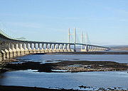
M4 motorway
The M4 motorway links London with South Wales. It is part of the unsigned European route E30. Other major places directly accessible from M4 junctions are Reading, Swindon, Bristol, Newport, Cardiff and Swansea...
Second Severn Crossing
Second Severn Crossing
The Second Severn Crossing is a bridge which carries the M4 motorway over the River Severn between England and Wales, inaugurated on 5 June 1996 by HRH The Prince of Wales to augment the traffic capacity of the original Severn Bridge built in 1966...
and the M48
M48 motorway
The M48 is a motorway in Great Britain joining Gloucestershire and Monmouthshire over the original Severn Bridge. The M48 is anomalously numbered, as it is entirely to the west of the M5 motorway and its number should really therefore begin with 5.-Route:...
Severn Bridge
Severn Bridge
The Severn Bridge is a suspension bridge spanning the River Severn between South Gloucestershire, just north of Bristol, England, and Monmouthshire in South Wales, via Beachley, a peninsula between the River Severn and River Wye estuary. It is the original Severn road crossing between England and...
. On both of these routes there is a significant toll
Toll road
A toll road is a privately or publicly built road for which a driver pays a toll for use. Structures for which tolls are charged include toll bridges and toll tunnels. Non-toll roads are financed using other sources of revenue, most typically fuel tax or general tax funds...
to be paid when travelling from England into Wales. The continuing existence and size of these tolls, which are set by legislation and revised annually, is a contentious issue, with some businesses and politicians in south Wales arguing that they stunt the growth of Wales' economy.
A competition was launched in 2005 to design one or more new iconic images, along the same lines as the "Angel of the North
Angel of the North
The Angel of the North is a contemporary sculpture, designed by Antony Gormley, which is located in Gateshead,formerly County Durham, England.It is a steel sculpture of an angel, standing tall, with wings measuring across...
", to be placed at the borders of Wales. This became known as the "Landmark Wales" project, and a shortlist of 15 proposals was unveiled in 2007. However, the proposal was shelved after it failed to receive Lottery
National Lottery (United Kingdom)
The National Lottery is the state-franchised national lottery in the United Kingdom and the Isle of Man.It is operated by Camelot Group, to whom the licence was granted in 1994, 2001 and again in 2007. The lottery is regulated by the National Lottery Commission, and was established by the then...
funding.
Place names
In general, placenames of Welsh originWelsh placenames
The placenames of Wales derive in most cases from the Welsh language, but have also been influenced by linguistic contact with the Romans, Anglo-Saxons, Vikings, Anglo-Normans and modern English...
are found to the west of the border, and those of English origin to the east. However, many historically Welsh names are also found east of the border, particularly around Oswestry in northern Shropshire, such as Gobowen
Gobowen
Gobowen is a large village in Shropshire, England, of population 3,927 .-History:The village was previously called Bryn-y-Castell, but the name in time changed to Gobowen. The name Gobowen is believed to originate from Gob and Owen who was believed to have rested his weary head there...
; in southern Shropshire, such as Clun
Clun
Clun is a small town in Shropshire, England. The town is located entirely in the Shropshire Hills Area of Outstanding Natural Beauty. The 2001 census recorded 642 people living in the town...
; and in southern Herefordshire, such as Kilpeck
Kilpeck
Kilpeck is a small village in Herefordshire, England. It is about southwest of Hereford, just south of the A465 road to Abergavenny, and about from the border with Wales....
and Pontrilas
Pontrilas
Pontrilas is a village in south Herefordshire, England, half a mile from the border with Wales. It is in the parish of Kentchurch and lies midway between Hereford and Abergavenny....
. Most of these areas were not incorporated fully into England until the 16th century, and native Welsh speakers still lived there until at least the 19th century. Equally, placenames of English origin can be found on the Welsh side of the border where there was Mercian and Norman settlement, particularly in the north east, such as Flint
Flint, Flintshire
Flint is a town in Flintshire, North Wales, lying on the estuary of the River Dee. It was the county town of the historic county of Flintshire and today is the third largest town in Flintshire. According to the 2001 Census the population of the community of Flint was 12,804...
and Prestatyn
Prestatyn
Prestatyn is a seaside resort, town and community in Denbighshire, North Wales. It is located on the Irish Sea coast, to the east of Rhyl. At the 2001 Census, Prestatyn had a population of 18,496.-Prehistory:...
; in central Powys, such as Newtown and Knighton; in south Pembrokeshire
Pembrokeshire
Pembrokeshire is a county in the south west of Wales. It borders Carmarthenshire to the east and Ceredigion to the north east. The county town is Haverfordwest where Pembrokeshire County Council is headquartered....
and Gower
Gower Peninsula
Gower or the Gower Peninsula is a peninsula in south Wales, jutting from the coast into the Bristol Channel, and administratively part of the City and County of Swansea. Locally it is known as "Gower"...
; and in eastern Monmouthshire, including Chepstow and Shirenewton
Shirenewton
Shirenewton is a village in Monmouthshire, south east Wales, UK. It is located 3 miles due west of Chepstow, 5 miles by road. The village stands around 500 feet above sea level, and has extensive views of the Severn Estuary and Bristol Channel....
. Although Welsh names exist for these places, they generally came into use after the English names.
See also
- List of Anglo-Welsh Wars
- History of WalesHistory of WalesThe history of Wales begins with the arrival of human beings in the region thousands of years ago. Neanderthals lived in what is now Wales, or Cymru in Welsh, at least 230,000 years ago, while Homo sapiens arrived by about 29,000 years ago...
- Offa's Dyke PathOffa's Dyke PathOffa's Dyke Path is a long distance footpath along the Welsh-English border. Opened in 1971, it is one of Britain's premier National Trails and draws walkers from throughout the world...
- Cultural relationship between the Welsh and the EnglishCultural relationship between the Welsh and the EnglishThe relationship between the Welsh and English within Great Britain is mostly characterised by tolerance, respect, and an intermixing of people and cultures. However, elements of mutual mistrust or dislike, and occasionally overt racism, also persist. Hatred or fear of the Welsh by the English or...
- Welsh MarchesWelsh MarchesThe Welsh Marches is a term which, in modern usage, denotes an imprecisely defined area along and around the border between England and Wales in the United Kingdom. The precise meaning of the term has varied at different periods...
- Severnside derbySevernside DerbyThe Severnside derby is a local derby in football in the United Kingdom between Welsh club Cardiff City F.C. and English club Bristol City F.C..The term Severnside derby can also be given to a match between Cardiff City F.C...
- Anglo–Scottish borderAnglo–Scottish borderThe Anglo-Scottish border is the official border and mark of entry between Scotland and England. It runs for 154 km between the River Tweed on the east coast and the Solway Firth in the west. It is Scotland's only land border...
- Republic of Ireland-United Kingdom borderRepublic of Ireland-United Kingdom borderThe Republic of Ireland–United Kingdom border is the boundary between the sovereign states of the Republic of Ireland and the United Kingdom of Great Britain and Northern Ireland...