

Black Mountains, Wales
Encyclopedia
The Black Mountains are a group of hills spread across parts of Powys
and Monmouthshire
in southeast Wales
, and extending across the national border into Herefordshire
, England
. They are the easternmost of the four ranges of hills that comprise the Brecon Beacons National Park, and are frequently confused with the westernmost, which is known as the Black Mountain. To confuse matters further, there is a peak in the Black Mountains called Black Mountain. The Black Mountains may be roughly defined as those hills contained within a triangle defined by the towns of Abergavenny
in the southeast, Hay-on-Wye
in the north and the village of Llangors
in the west. Another 'gateway' town to the Black Mountains is Talgarth
.
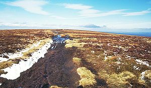
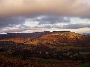 The highest mountain in the group is Waun Fach
whose heavily eroded peat summit plateau attains a height of 811 metres (2,661 ft). Other significant summits towards the northern edge of the range include the 703 metres (2,306 ft) peak of Black Mountain with its northern outpost of Hay Bluff
(Welsh
: Penybegwn), 677 metres (2,221 ft), Rhos Dirion
, 713 metres (2,339 ft) and Lord Hereford's Knob or Twmpa
, 690 metres (2,264 ft). Towards the south of the range are the more independent summits of Crug Mawr
at 550 metres (1,804 ft), Pen Allt-mawr
at 719 metres (2,359 ft) and the 701 metres (2,300 ft) peak of Pen Cerrig-calch
which rises prominently above the Usk Valley.
Outlying summits, all of which are classed as Marilyns
, include the Sugar Loaf
(Welsh
: Pen-y-Fal), Mynydd Troed
and Mynydd Llangorse
. The lower and separate hills of Allt yr Esgair
, Myarth
, Bryn Arw
and Ysgyryd Fawr
(also known as 'The Skirrid', Skyrrid or 'Holy Mountain') are scattered along the southern fringe of the Black Mountains.
In his work People of the Black Mountains
, Raymond Williams
described the Black Mountains thus:
and dating from the Devonian
period. This thick sedimentary sequence comprises sandstones, mudstones, siltstones and numerous thin limestones. The exception is the summit area of Pen Cerrig-calch
where a thin sequence of Carboniferous
rocks occur, an outlier of the more extensive outcrop to the south of the Usk
valley. The lower slopes of these hills are formed from the mudstone-rich St Maughans beds at the top of which lies a calcrete - a discontinuous limestone band known as the Ffynnon Limestone. Above this are the sandstone-dominated Senni Beds which form the upper reaches of much of the range. Higher again are the Brownstones which form the summit areas of the central and southern parts of the range.
The Old Red Sandstone extends back into the late Silurian period and forward into the earliest part of the Carboniferous period. The body of rock
, or facies
, is dominated by alluvial sediment
s and conglomerates
at its base, and progresses to a combination of dune
s, lake
s and river
sediments. The familiar red colour of these rocks arises from the presence of iron oxide
but not all the Old Red Sandstone is red or sandstone — the sequence also includes conglomerates
, mudstones, siltstones and thin limestones and colours can range from grey and green through red to purple.
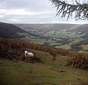 The area lay at the margins of the British ice-sheet during the ice ages; these hills were shaped by ice from a source in mid-Wales rather than generating any major glaciers of their own. Non-local rock fragments within the glacial till show that Wye valley ice penetrated the Rhiangoll valley from the north, moving over the low col at Pengenffordd. No such evidence has been found in the Vale of Ewyas
though the profile of this valley strongly suggests the presence of a major glacier. The valleys of the Grwyne Fawr and Grwyne Fechan were probably ice-free during the last ice age. One result of the over-steepening of valley sides by glacial action is the suite of landslips affecting the range, notably in the Vale of Ewyas. The most impressive of all is that at Darren and Cwmyoy. Another impressive set of landslip forms can be seen at Black Darren and Red Darren ('Darren' signifies 'edge' in Welsh) on the eastern side of the Hatterrall ridge west of Longtown
.
for the production of lime for agricultural use and in buildings. Old Red Sandstone has also frequently been used in buildings in Herefordshire
, Monmouthshire
and the former Brecknockshire
(now south Powys) of south Wales.
, mountainbikers and horseriders. The Offa's Dyke
National Trail
runs along the border between England and Wales, whilst both the Beacons Way and the Marches Way
also pass through the Black Mountains. The Three Rivers Ride runs along the northern slopes of the massif. The range's great northern escarpment offers excellent opportunities for gliding
, hang gliding
and paragliding
as winds are forced up and over the hills.
 There are several attractive villages and hamlets in this area. The Skirrid Mountain Inn
also has a wider reputation, being claimed as the oldest public house
in Wales
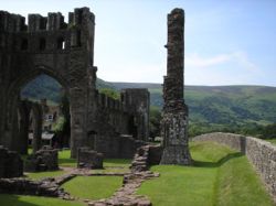
and mentioned in records from AD 1100. Antiquities include Llanthony Priory
in the Vale of Ewyas
, ruined Craswall Priory
, Tretower Castle
, Tretower Court
, the Iron Age
hill fort
of Crug Hywel
, and the remains of Castell Dinas
, an 11th to 13th century castle
built on the site of an Iron Age
hillfort between Talgarth
and Crickhowell
. Cwmyoy
and Partrishow
churches are also worth visiting.
The youth hostel at Capel-y-ffin
closed in late 2007. The town of books or Hay-on-Wye
lies just to the north. It was the first booktown
to be established and there are more than two dozen second-hand bookshops to explore. Some specialise in specific subjects, so there is a wide choice for browsers.
, Llangors
, Talgarth
, Crickhowell
, Cwmdu
, each in Powys, Abergavenny
in Monmouthshire and Longtown
in Herefordshire. Many act as bases for accessing the hills all year round.
lived at Capel-y-ffin between 1924 and 1928. The artist and poet David Jones
worked in the area during the same period.
Powys
Powys is a local-government county and preserved county in Wales.-Geography:Powys covers the historic counties of Montgomeryshire and Radnorshire, most of Brecknockshire , and a small part of Denbighshire — an area of 5,179 km², making it the largest county in Wales by land area.It is...
and Monmouthshire
Monmouthshire
Monmouthshire is a county in south east Wales. The name derives from the historic county of Monmouthshire which covered a much larger area. The largest town is Abergavenny. There are many castles in Monmouthshire .-Historic county:...
in southeast Wales
Wales
Wales is a country that is part of the United Kingdom and the island of Great Britain, bordered by England to its east and the Atlantic Ocean and Irish Sea to its west. It has a population of three million, and a total area of 20,779 km²...
, and extending across the national border into Herefordshire
Herefordshire
Herefordshire is a historic and ceremonial county in the West Midlands region of England. For Eurostat purposes it is a NUTS 3 region and is one of three counties that comprise the "Herefordshire, Worcestershire and Gloucestershire" NUTS 2 region. It also forms a unitary district known as the...
, England
England
England is a country that is part of the United Kingdom. It shares land borders with Scotland to the north and Wales to the west; the Irish Sea is to the north west, the Celtic Sea to the south west, with the North Sea to the east and the English Channel to the south separating it from continental...
. They are the easternmost of the four ranges of hills that comprise the Brecon Beacons National Park, and are frequently confused with the westernmost, which is known as the Black Mountain. To confuse matters further, there is a peak in the Black Mountains called Black Mountain. The Black Mountains may be roughly defined as those hills contained within a triangle defined by the towns of Abergavenny
Abergavenny
Abergavenny , meaning Mouth of the River Gavenny, is a market town in Monmouthshire, Wales. It is located 15 miles west of Monmouth on the A40 and A465 roads, 6 miles from the English border. Originally the site of a Roman fort, Gobannium, it became a medieval walled town within the Welsh Marches...
in the southeast, Hay-on-Wye
Hay-on-Wye
Hay-on-Wye , often described as "the town of books", is a small market town and community in Powys, Wales.-Location:The town lies on the east bank of the River Wye and is within the Brecon Beacons National Park, just north of the Black Mountains...
in the north and the village of Llangors
Llangors
Llangors is a small village in southern Powys, Mid Wales, and also falls inside the Brecon Beacons National Park....
in the west. Another 'gateway' town to the Black Mountains is Talgarth
Talgarth
Talgarth is a small market town and community in southern Powys , Mid Wales, with a population of 1,645. Notable buildings in the town include its 14th-century parish church and 13th century Pele Tower, located in the town centre, now home to the Tourist Information and Resource Centre...
.
Mountains
Waun Fach
Waun Fach is the highest mountain in the Black Mountains in south-eastern Wales. It is one of the three Marilyns over 600m that make up the range, the others being Black Mountain and Mynydd Troed. To the north Rhos Fawr and the Radnor Forest can be seen.It is situated at the head of the Grwyne...
whose heavily eroded peat summit plateau attains a height of 811 metres (2,661 ft). Other significant summits towards the northern edge of the range include the 703 metres (2,306 ft) peak of Black Mountain with its northern outpost of Hay Bluff
Hay Bluff
Hay Bluff is a prominent hill at the northern tip of the Black Mountains, an extensive upland massif which straddles the border between south-east Wales and England...
(Welsh
Welsh language
Welsh is a member of the Brythonic branch of the Celtic languages spoken natively in Wales, by some along the Welsh border in England, and in Y Wladfa...
: Penybegwn), 677 metres (2,221 ft), Rhos Dirion
Rhos Dirion
Rhos Dirion is a top of Waun Fach in the Black Mountains in south-eastern Wales. It is the highest point on the Rhos Dirion - Chwarel y Fan ridge....
, 713 metres (2,339 ft) and Lord Hereford's Knob or Twmpa
Twmpa
Twmpa or Lord Hereford's Knob is a mountain in south-east Wales, forming a part of the great northwest scarp of the Black Mountains. It lies 3 km west of the border with England, and around 7 km south of Hay-on-Wye. To the northeast lies the Gospel Pass through which runs a minor road...
, 690 metres (2,264 ft). Towards the south of the range are the more independent summits of Crug Mawr
Crug Mawr
Crug Mawr is a hill in the Black Mountains in the Brecon Beacons National Park in southern Powys, Wales. Its summit at a height of 550m is marked by a trig point. The peak sits high above the valleys of the Grwyne Fawr and Grwyne Fechan to the north of the more well-known Sugar Loaf...
at 550 metres (1,804 ft), Pen Allt-mawr
Pen Allt-mawr
Pen Allt-mawr is subsidiary summit of Waun Fach and the third highest peak in the Black Mountains in south-eastern Wales. It lies near the end of the westernmost of Waun Fach's south ridges. It is a very recognisable and prominent peak of the Black Mountains.It summit is stony and has a large...
at 719 metres (2,359 ft) and the 701 metres (2,300 ft) peak of Pen Cerrig-calch
Pen Cerrig-Calch
Pen Cerrig-calch is a subsidiary summit of Waun Fach in the Black Mountains in the Brecon Beacons National Park in southern Powys, Wales. Its summit, at a height of 701m , is marked by a trig point...
which rises prominently above the Usk Valley.
Outlying summits, all of which are classed as Marilyns
Marilyn (hill)
A Marilyn is a mountain or hill in the United Kingdom, Republic of Ireland or Isle of Man with a relative height of at least 150 metres , regardless of absolute height or other merit...
, include the Sugar Loaf
Sugar Loaf Mountain, Wales
Sugar Loaf, sometimes called The Sugar Loaf , is a mountain situated north-west of Abergavenny in Monmouthshire, Wales. It is the most southern and lowest of the summit peaks of the Black Mountains, with a height of 1,955 feet ....
(Welsh
Welsh language
Welsh is a member of the Brythonic branch of the Celtic languages spoken natively in Wales, by some along the Welsh border in England, and in Y Wladfa...
: Pen-y-Fal), Mynydd Troed
Mynydd Troed
Mynydd Troed is a hill in the Black Mountains of the Brecon Beacons National Park in Powys, south Wales. It lies 3 miles south of Talgarth and 2 miles northeast of the village of Llangors on the western side of the range...
and Mynydd Llangorse
Mynydd Llangorse
Mynydd Llangorse is a hill on the western edge of the Black Mountains in the Brecon Beacons National Park in Powys, south Wales. It lies two miles east of Llangors and its lake and 5 miles south of Talgarth. Its summit at 515m overtops the location 600m to the south at which a trig point is sited...
. The lower and separate hills of Allt yr Esgair
Allt yr Esgair
Allt yr Esgair is a hill in the Brecon Beacons National Park in the county of Powys, south Wales. It is commonly referred to locally as simply 'The Allt'. The Welsh name signifies 'wooded slope of the ridge'. It takes the form of a northwest-southeast aligned ridge which rises to a height of 393m...
, Myarth
Myarth
Myarth is a hill in the Usk Valley in the county of Powys in South Wales, about 2 miles east of Crickhowell. Its summit at is covered by trees, whilst the larger part of its slopes are also wooded. It is listed as a Marilyn. Myarth has an elongate form commonly ascribed to erosion by the...
, Bryn Arw
Bryn Arw
Bryn Arw is a hill in the Black Mountains of the Brecon Beacons National Park in Monmouthshire, south Wales. It lies 4 km north of the town of Abergavenny and 1.5 miles west of the village of Llanvihangel Crucorney...
and Ysgyryd Fawr
Ysgyryd Fawr
Ysgyryd Fawr is the most easterly of the Black Mountains in Wales, part of the Brecon Beacons National Park. The name is often anglicised to The Skirrid or Skirrid Fawr, and the mountain is also known as Holy Mountain or Sacred Hill. The spelling Skyrrid is also encountered in older literature...
(also known as 'The Skirrid', Skyrrid or 'Holy Mountain') are scattered along the southern fringe of the Black Mountains.
In his work People of the Black Mountains
People of the Black Mountains
People of the Black Mountains is an historical novel by Raymond Williams.This book is a work in two volumes, published in 1989 and 1990. It features a great diversity of people in a single place across the ages. Most of them are ordinary people living unprivileged lives. It is told thorough a...
, Raymond Williams
Raymond Williams
Raymond Henry Williams was a Welsh academic, novelist and critic. He was an influential figure within the New Left and in wider culture. His writings on politics, culture, the mass media and literature are a significant contribution to the Marxist critique of culture and the arts...
described the Black Mountains thus:
See this layered sandstone among the short mountain grass. Place your right hand on it, palm downwards. See where the sun rises and where it stands at noon. Direct your middle finger midway between them. Spread your fingers, not widely. You now hold this place in your hand - the six rivers rise on the plateau on the back of your hand. The first river now called Mynwy or Monnow flows at the outside edge of your thumb. The second river now called Olchon flows between your thumb and the first finger to join the Mynwy at the top of your thumb. The third river now called Honddu flows between your first and second fingers and then curves to join the Mynwy away from your hand. The fourth river now called Grwyne Fawr flows between your second and third fingers and then curves the other way joining the fifth river now called Grwyne Fechan that has been flowing between your third and your little finger. The sixth river now called Rhiangoll flows at the outside edge of your little finger. Beyond your hand are the two rivers to the sea ; Mynwy carrying Olchon and Honddu flows into the circling Wye. Grwyne and Rhiangoll flow into the Usk. Wye and Usk separated by the forest of Gwent flow into the Severn Sea. The ridges of your five fingers and the plateau of the back of your hand are now called the Black Mountains. Your thumb is Crib y Gath or the Cats Back. Your first finger is Hatterall Hill. Your second finger is Ffawyddog with Bal Mawr at the knuckle. Your third finger is Gader with Gader Fawr at the knuckle. Your little finger is Allt Mawr and its nail is Crug Hywel giving its name to Crickhowell below it. On the back of your hand are Twyn y Llech and Twmpa and Rhos Dirion and Waun Fach. Mynwy and Olchon flow from Twyn y Llech. Honddu flows from Twyn y Llech and Twmpa. Grwyne Fawr flows from Rhos Dirion. Grwyne Fechan and Rhiangoll flow from Waun Fach. You hold the shapes in the names in your hand.
Bedrock
The Black Mountains are composed almost exclusively of rocks assigned to the Old Red SandstoneOld Red Sandstone
The Old Red Sandstone is a British rock formation of considerable importance to early paleontology. For convenience the short version of the term, 'ORS' is often used in literature on the subject.-Sedimentology:...
and dating from the Devonian
Devonian
The Devonian is a geologic period and system of the Paleozoic Era spanning from the end of the Silurian Period, about 416.0 ± 2.8 Mya , to the beginning of the Carboniferous Period, about 359.2 ± 2.5 Mya...
period. This thick sedimentary sequence comprises sandstones, mudstones, siltstones and numerous thin limestones. The exception is the summit area of Pen Cerrig-calch
Pen Cerrig-Calch
Pen Cerrig-calch is a subsidiary summit of Waun Fach in the Black Mountains in the Brecon Beacons National Park in southern Powys, Wales. Its summit, at a height of 701m , is marked by a trig point...
where a thin sequence of Carboniferous
Carboniferous
The Carboniferous is a geologic period and system that extends from the end of the Devonian Period, about 359.2 ± 2.5 Mya , to the beginning of the Permian Period, about 299.0 ± 0.8 Mya . The name is derived from the Latin word for coal, carbo. Carboniferous means "coal-bearing"...
rocks occur, an outlier of the more extensive outcrop to the south of the Usk
Usk
Usk is a small town in Monmouthshire, Wales, situated 10 miles northeast of Newport.The River Usk flows through the town and is spanned by an ancient, arched stone bridge at the western entrance to the town. A castle above the town overlooks the ancient Anglo-Welsh border crossing - the river can...
valley. The lower slopes of these hills are formed from the mudstone-rich St Maughans beds at the top of which lies a calcrete - a discontinuous limestone band known as the Ffynnon Limestone. Above this are the sandstone-dominated Senni Beds which form the upper reaches of much of the range. Higher again are the Brownstones which form the summit areas of the central and southern parts of the range.
The Old Red Sandstone extends back into the late Silurian period and forward into the earliest part of the Carboniferous period. The body of rock
Rock (geology)
In geology, rock or stone is a naturally occurring solid aggregate of minerals and/or mineraloids.The Earth's outer solid layer, the lithosphere, is made of rock. In general rocks are of three types, namely, igneous, sedimentary, and metamorphic...
, or facies
Facies
In geology, facies are a body of rock with specified characteristics. Ideally, a facies is a distinctive rock unit that forms under certain conditions of sedimentation, reflecting a particular process or environment....
, is dominated by alluvial sediment
Sediment
Sediment is naturally occurring material that is broken down by processes of weathering and erosion, and is subsequently transported by the action of fluids such as wind, water, or ice, and/or by the force of gravity acting on the particle itself....
s and conglomerates
Conglomerate (geology)
A conglomerate is a rock consisting of individual clasts within a finer-grained matrix that have become cemented together. Conglomerates are sedimentary rocks consisting of rounded fragments and are thus differentiated from breccias, which consist of angular clasts...
at its base, and progresses to a combination of dune
Dune
In physical geography, a dune is a hill of sand built by wind. Dunes occur in different forms and sizes, formed by interaction with the wind. Most kinds of dunes are longer on the windward side where the sand is pushed up the dune and have a shorter "slip face" in the lee of the wind...
s, lake
Lake
A lake is a body of relatively still fresh or salt water of considerable size, localized in a basin, that is surrounded by land. Lakes are inland and not part of the ocean and therefore are distinct from lagoons, and are larger and deeper than ponds. Lakes can be contrasted with rivers or streams,...
s and river
River
A river is a natural watercourse, usually freshwater, flowing towards an ocean, a lake, a sea, or another river. In a few cases, a river simply flows into the ground or dries up completely before reaching another body of water. Small rivers may also be called by several other names, including...
sediments. The familiar red colour of these rocks arises from the presence of iron oxide
Iron oxide
Iron oxides are chemical compounds composed of iron and oxygen. All together, there are sixteen known iron oxides and oxyhydroxides.Iron oxides and oxide-hydroxides are widespread in nature, play an important role in many geological and biological processes, and are widely utilized by humans, e.g.,...
but not all the Old Red Sandstone is red or sandstone — the sequence also includes conglomerates
Conglomerate (geology)
A conglomerate is a rock consisting of individual clasts within a finer-grained matrix that have become cemented together. Conglomerates are sedimentary rocks consisting of rounded fragments and are thus differentiated from breccias, which consist of angular clasts...
, mudstones, siltstones and thin limestones and colours can range from grey and green through red to purple.
Glacial legacy
Vale of Ewyas
The Vale of Ewyas is the steeply-sided and secluded valley of the Afon Honddu, in the Black Mountains of south Wales and within the Brecon Beacons National Park. As well as its outstanding beauty, it is known for the ruins of Llanthony Priory, and for several noteworthy churches such as those at...
though the profile of this valley strongly suggests the presence of a major glacier. The valleys of the Grwyne Fawr and Grwyne Fechan were probably ice-free during the last ice age. One result of the over-steepening of valley sides by glacial action is the suite of landslips affecting the range, notably in the Vale of Ewyas. The most impressive of all is that at Darren and Cwmyoy. Another impressive set of landslip forms can be seen at Black Darren and Red Darren ('Darren' signifies 'edge' in Welsh) on the eastern side of the Hatterrall ridge west of Longtown
Longtown
Longtown may refer to several places:in the United Kingdom:* Longtown, Cumbria* Longtown, Herefordshire* Longtown, County Antrim, a townland in County Antrim, Northern Irelandin the United States:* Longtown, Missouri* Longtown, Mississippi...
.
Exploitation
Scattered around the range are innumerable small quarries, virtually all of which now lie abandoned, once a source of walling and roofing stone for local use. In places the thin Devonian limestones were worked to feed limekilnsLimekilns
Limekilns, a village in Fife, Scotland, lies on the shore of the Firth of Forth.Unlike the neighbouring village of Charlestown, Limekilns is an extremely old settlement dating back to the 14th century. The oldest building in the village is without doubt The King's Cellar, a large and somewhat...
for the production of lime for agricultural use and in buildings. Old Red Sandstone has also frequently been used in buildings in Herefordshire
Herefordshire
Herefordshire is a historic and ceremonial county in the West Midlands region of England. For Eurostat purposes it is a NUTS 3 region and is one of three counties that comprise the "Herefordshire, Worcestershire and Gloucestershire" NUTS 2 region. It also forms a unitary district known as the...
, Monmouthshire
Monmouthshire
Monmouthshire is a county in south east Wales. The name derives from the historic county of Monmouthshire which covered a much larger area. The largest town is Abergavenny. There are many castles in Monmouthshire .-Historic county:...
and the former Brecknockshire
Brecknockshire
Brecknockshire , also known as the County of Brecknock, Breconshire, or the County of Brecon is one of thirteen historic counties of Wales, and a former administrative county.-Geography:...
(now south Powys) of south Wales.
Activities in the Black Mountains
The area is popular for hillwalkersHillwalking
In the British Isles, the terms hillwalking or fellwalking are commonly used to describe the recreational outdoor activity of walking on hills and mountains, often with the intention of visiting their summits...
, mountainbikers and horseriders. The Offa's Dyke
Offa's Dyke
Offa's Dyke is a massive linear earthwork, roughly followed by some of the current border between England and Wales. In places, it is up to wide and high. In the 8th century it formed some kind of delineation between the Anglian kingdom of Mercia and the Welsh kingdom of Powys...
National Trail
National Trails
National Trails are long distance footpaths and bridleways in England and Wales. They are administered by Natural England and the Countryside Council for Wales, statutory agencies of the UK government....
runs along the border between England and Wales, whilst both the Beacons Way and the Marches Way
Marches Way
The Marches Way is a partially waymarked long distance footpath in the United Kingdom. It runs 351 kilometres / 218 miles through the Welsh–English borderlands, traditionally known as the Welsh Marches and links the cities of Chester in the north and Cardiff in the south.-The route:The route...
also pass through the Black Mountains. The Three Rivers Ride runs along the northern slopes of the massif. The range's great northern escarpment offers excellent opportunities for gliding
Gliding
Gliding is a recreational activity and competitive air sport in which pilots fly unpowered aircraft known as gliders or sailplanes using naturally occurring currents of rising air in the atmosphere to remain airborne. The word soaring is also used for the sport.Gliding as a sport began in the 1920s...
, hang gliding
Hang gliding
Hang gliding is an air sport in which a pilot flies a light and unmotorized foot-launchable aircraft called a hang glider ....
and paragliding
Paragliding
Paragliding is the recreational and competitive adventure sport of flying paragliders: lightweight, free-flying, foot-launched glider aircraft with no rigid primary structure...
as winds are forced up and over the hills.
Local attractions
The Skirrid Mountain Inn
The Skirrid Mountain Inn is a public house in the small village of Llanfihangel Crucorney, just a few miles north of Abergavenny, Monmouthshire. Perhaps the oldest pub in Wales, listed in chronicles from 1100...
also has a wider reputation, being claimed as the oldest public house
Public house
A public house, informally known as a pub, is a drinking establishment fundamental to the culture of Britain, Ireland, Australia and New Zealand. There are approximately 53,500 public houses in the United Kingdom. This number has been declining every year, so that nearly half of the smaller...
in Wales
Wales
Wales is a country that is part of the United Kingdom and the island of Great Britain, bordered by England to its east and the Atlantic Ocean and Irish Sea to its west. It has a population of three million, and a total area of 20,779 km²...
and mentioned in records from AD 1100. Antiquities include Llanthony Priory
Llanthony Priory
Llanthony Priory is a partly ruined former Augustinian priory in the secluded Vale of Ewyas, a steep sided once glaciated valley within the Black Mountains area of the Brecon Beacons National Park in Monmouthshire, south east Wales. It lies seven miles north of Abergavenny on an old road to Hay...
in the Vale of Ewyas
Vale of Ewyas
The Vale of Ewyas is the steeply-sided and secluded valley of the Afon Honddu, in the Black Mountains of south Wales and within the Brecon Beacons National Park. As well as its outstanding beauty, it is known for the ruins of Llanthony Priory, and for several noteworthy churches such as those at...
, ruined Craswall Priory
Craswall Priory
-References:...
, Tretower Castle
Tretower Castle
thumb|320px|right|Tretower CastleTretower castle is a castle in the village of Tretower in the county of Powys, Wales.-History:Tretower was founded as a motte and bailey castle. In the 12th century, a shell-keep was added to the motte. By c.1230 a tall cylindrical keep was added to the inside of...
, Tretower Court
Tretower Court
Tretower Court is a medieval fortified manor house situated in the village of Tretower, near Crickhowell in modern day Powys, previously within the historical county of Breconshire or Brecknockshire.- Local & national importance :...
, the Iron Age
Iron Age
The Iron Age is the archaeological period generally occurring after the Bronze Age, marked by the prevalent use of iron. The early period of the age is characterized by the widespread use of iron or steel. The adoption of such material coincided with other changes in society, including differing...
hill fort
Hill fort
A hill fort is a type of earthworks used as a fortified refuge or defended settlement, located to exploit a rise in elevation for defensive advantage. They are typically European and of the Bronze and Iron Ages. Some were used in the post-Roman period...
of Crug Hywel
Crug Hywel
Crug Hywel is a flat-topped hill at the southern edge of the Black Mountains in south-east Wales.It rises to 451 m above sea level, from the southern flank of Pen Cerrig-calch , and overlooks the town of Crickhowell , to which it gives its name.The summit of the hill is entirely taken up by...
, and the remains of Castell Dinas
Castell Dinas
Castell Dinas is a hillfort and castle in southern Powys, Wales. At 450 m it has the highest castle in England and Wales. It is positioned to defend the Rhiangoll pass between Talgarth and Crickhowell....
, an 11th to 13th century castle
Castle
A castle is a type of fortified structure built in Europe and the Middle East during the Middle Ages by European nobility. Scholars debate the scope of the word castle, but usually consider it to be the private fortified residence of a lord or noble...
built on the site of an Iron Age
Iron Age
The Iron Age is the archaeological period generally occurring after the Bronze Age, marked by the prevalent use of iron. The early period of the age is characterized by the widespread use of iron or steel. The adoption of such material coincided with other changes in society, including differing...
hillfort between Talgarth
Talgarth
Talgarth is a small market town and community in southern Powys , Mid Wales, with a population of 1,645. Notable buildings in the town include its 14th-century parish church and 13th century Pele Tower, located in the town centre, now home to the Tourist Information and Resource Centre...
and Crickhowell
Crickhowell
Crickhowell is a small town in Powys, Mid Wales.-Location:The name Crickhowell is taken from that of the nearby Iron Age hill fort of Crug Hywel above the town, the Welsh language name being anglicised by map-makers and local English-speaking people...
. Cwmyoy
Cwmyoy
Cwmyoy is an extensive rural parish in Monmouthshire, Wales. Alternate spellings include Cwm Iau, the name translating from the Welsh as "valley of the yoke"...
and Partrishow
Partrishow
Partrishow, also known as Patricio or Patrishow, is a small village in the Black Mountains of South Wales, within the Brecon Beacons National Park.-Location:...
churches are also worth visiting.
The youth hostel at Capel-y-ffin
Capel-y-ffin
Capel-y-ffin is a hamlet near the English-Welsh border in Powys, Wales, in the Black Mountains within the Brecon Beacons National Park. The nearest town is Hay-on-Wye, some to the north-west.-The Chapel:...
closed in late 2007. The town of books or Hay-on-Wye
Hay-on-Wye
Hay-on-Wye , often described as "the town of books", is a small market town and community in Powys, Wales.-Location:The town lies on the east bank of the River Wye and is within the Brecon Beacons National Park, just north of the Black Mountains...
lies just to the north. It was the first booktown
Book town
A book town is a town or village with a large number of second-hand or antiquarian book shops. These shops, and sometimes also literary festivals, attract bibliophile tourists to them...
to be established and there are more than two dozen second-hand bookshops to explore. Some specialise in specific subjects, so there is a wide choice for browsers.
Towns and villages
Settlements in and around the Black Mountains include Hay-on-WyeHay-on-Wye
Hay-on-Wye , often described as "the town of books", is a small market town and community in Powys, Wales.-Location:The town lies on the east bank of the River Wye and is within the Brecon Beacons National Park, just north of the Black Mountains...
, Llangors
Llangors
Llangors is a small village in southern Powys, Mid Wales, and also falls inside the Brecon Beacons National Park....
, Talgarth
Talgarth
Talgarth is a small market town and community in southern Powys , Mid Wales, with a population of 1,645. Notable buildings in the town include its 14th-century parish church and 13th century Pele Tower, located in the town centre, now home to the Tourist Information and Resource Centre...
, Crickhowell
Crickhowell
Crickhowell is a small town in Powys, Mid Wales.-Location:The name Crickhowell is taken from that of the nearby Iron Age hill fort of Crug Hywel above the town, the Welsh language name being anglicised by map-makers and local English-speaking people...
, Cwmdu
Cwmdu
Cwmdu may refer to:*Cwmdu, Swansea*Cwmdu, Carmarthenshire*Cwmdu, PowysCwmdu may refer to:*Cwmdu, Swansea*Cwmdu, Carmarthenshire*Cwmdu, PowysCwmdu may refer to:*Cwmdu, Swansea*Cwmdu, Carmarthenshire*Cwmdu, Powys...
, each in Powys, Abergavenny
Abergavenny
Abergavenny , meaning Mouth of the River Gavenny, is a market town in Monmouthshire, Wales. It is located 15 miles west of Monmouth on the A40 and A465 roads, 6 miles from the English border. Originally the site of a Roman fort, Gobannium, it became a medieval walled town within the Welsh Marches...
in Monmouthshire and Longtown
Longtown, Herefordshire
Longtown is a linear village and civil parish in Herefordshire, England. The civil parish also includes the village of Clodock. In the 2001 census the population of the parish was 474.- Location :...
in Herefordshire. Many act as bases for accessing the hills all year round.
Cultural Associations
The controversial artist and typeface designer Eric GillEric Gill
Arthur Eric Rowton Gill was a British sculptor, typeface designer, stonecutter and printmaker, who was associated with the Arts and Crafts movement...
lived at Capel-y-ffin between 1924 and 1928. The artist and poet David Jones
David Jones (poet)
David Jones CH was both a painter and one of the first generation British modernist poets. As a painter he worked chiefly in watercolor, painting portraits and animal, landscape, legendary and religious subjects. He was also a wood-engraver and designer of inscriptions. As a writer he was...
worked in the area during the same period.
Fiction
Books set in or around the Black Mountains include:- People of the Black MountainsPeople of the Black MountainsPeople of the Black Mountains is an historical novel by Raymond Williams.This book is a work in two volumes, published in 1989 and 1990. It features a great diversity of people in a single place across the ages. Most of them are ordinary people living unprivileged lives. It is told thorough a...
by Raymond WilliamsRaymond WilliamsRaymond Henry Williams was a Welsh academic, novelist and critic. He was an influential figure within the New Left and in wider culture. His writings on politics, culture, the mass media and literature are a significant contribution to the Marxist critique of culture and the arts...
( two books of an intended trilogy) - On The Black HillOn The Black HillOn the Black Hill is a novel by Bruce Chatwin published in 1982 and winner of the James Tait Black Memorial Prize for that year. In 1987 it was made into a film, directed by Andrew Grieve.- Plot summary :...
by Bruce ChatwinBruce ChatwinCharles Bruce Chatwin was an English novelist and travel writer. He won the James Tait Black Memorial Prize for his novel On the Black Hill...
(also adapted as a film) - ResistanceResistance (Owen Sheers novel)Resistance is a novel by Welsh poet and author Owen Sheers. The plot centres around the inhabitants of a valley near Abergavenny in Wales in 1944–45, shortly after the failure of Operation Overlord and a successful German counter-invasion of Britain , and a group of German Wehrmacht soldiers who...
by Owen SheersOwen SheersOwen Sheers is a Welsh poet, author, playwright, actor and TV presenter.-Biography:Owen Sheers was born in Suva, Fiji in 1974 and brought up in Abergavenny, South Wales... - Running for the Hills: a family story by Horatio ClareHoratio ClareHoratio Clare is an author and journalist. He worked at the BBC as a producer on Front Row , Night Waves and The Verb . He has written two memoirs, 'Running for the Hills' and 'Truant: Notes from the Slippery Slope' and a travel book, 'A Single Swallow'...