

Long Island Sound link
Encyclopedia
The Long Island Sound link is a proposed bridge
or tunnel
that would link Long Island
to the south with New York
or Connecticut
to the north across Long Island Sound
. The most recent proposal involves a tunnel between Rye, New York
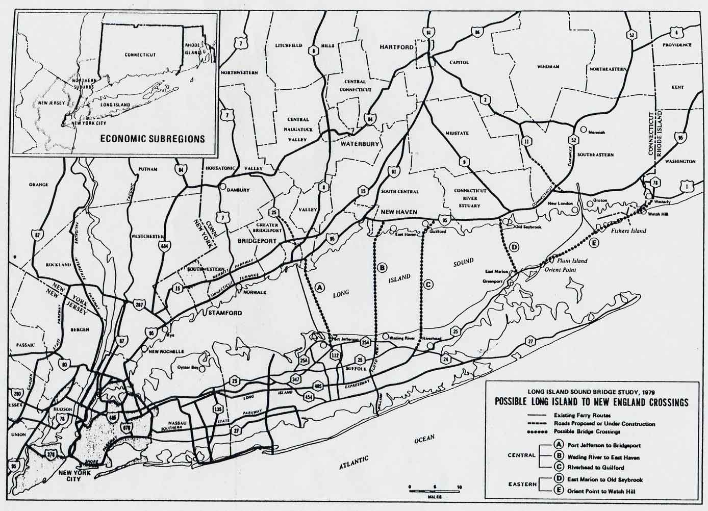
on the mainland and Oyster Bay on the island. Feasibility studies for both bridges and tunnels have been conducted for numerous entry points, as listed in the chart below.
, Manhattan
, and the Bronx. People who wish to travel from Long Island to New York's mainland or New England
via automobile have no better option than cross the Throgs Neck Bridge
or the Whitestone Bridge, which are located on the northwestern corner of Long Island. Ferry
service between Connecticut and Long Island is available year round; the drawback is that it is a slow-moving vessel, and it therefore takes enough time to cross the Long Island Sound
that, if a traveler is going some place in western Connecticut, it may be more time-effective to drive rather than use the ferry, even from points farther east than Port Jefferson
, the very town from which the ferry originates. Private companies operate automobile ferries between Bridgeport, Connecticut
and Port Jefferson on central Long Island, and between New London, Connecticut
and Orient Point on eastern Long Island.
A bridge or tunnel to the center of the island would make most of the island more accessible, and would reduce the travel time of certain routes by hours. However, the cost of a bridge would be large and it would be likely to have adverse environmental impacts. If built, a span across the widest portion of the Sound between New Haven and Shoreham would be approximately 35-40 km (22-25 miles) in length, possibly making it one of the longest bridges in the world.
All nine ideas were discussed in the 1950s, 1960s, and 1970s, but all were canceled. Some were reconsidered during the 1990s, but the New York State Department of Transportation
backed away from the idea in belief that it would not relieve congestion. Long Islanders seem to favor a bridge but New England
ers are not very supportive of the idea, claiming that it would benefit Long Island
at their expense.
In seven years, Long Island underwent the transformation that Sells had expected, and the east–west arterials between Long Island and New York City
, such as the Northern State Parkway
and the Long Island Expressway, were congested with commuters. Motorists bound for New England
or upstate regions of New York had to take either the Throgs Neck Bridge
or the Bronx–Whitestone Bridge, and both bridges were already reaching their designed capacities. Robert Moses, chairman of the Triborough Bridge and Tunnel Authority
, worked with the Department of Public Works to commission a $150,000 (1964 USD) study by the firm Madigan-Hyland to study the feasibility of a bridge across the sound.
Moses revealed the results of the study to the Nassau and Suffolk Regional Planning Board in February 1966. The Oyster Bay – Rye Bridge (originally the Bayville – Rye Bridge) was proposed to complete the Interstate 287 (I-287) beltway around the New York Metropolitan Area. This was to be done by constructing a 6.1 miles (9.8 km) long cable-stayed suspension bridge bridge from the Cross Westchester Expressway (I-287) in Rye
to the Seaford – Oyster Bay Expressway (NY 135) in Nassau County. The proposed bridge was to cost $150 million (1966 USD) and had the support of Governor Nelson Rockefeller
and many officials on Long Island.
On March 1, 1968, the Triborough Bridge and Tunnel Authority merged with the Metropolitan Transportation Authority
(MTA), and Moses was demoted from chairman and given a lower position on the promise that he would have a leading role in construction of the bridge. However, this was only made as a promise, not a guarantee. Also, a number of excuses for delaying construction of the bridge were coming from the governor's offices. In 1969, the office said that bond market, which would help finance the bridge, was too soft. The next year, there was a Gubernatorial campaign for Rockefeller, and with the affected communities up in arms against him, he did not want to be put on the spot while running for re-election as governor. In 1971, the excuse was that financial problems resurfaced on the proposed bridge and delayed it yet another year. The following year, the campaign for the Republican
-held legislature in New York and Governor were yet another reason to delay construction. With each delay out of the governor's office, Moses kept assuring that the bridge would begin construction the next year.
However, in that time frame of excuses, Governor Rockefeller ordered a halt to the heated issue in 1970 to conduct another feasibility study, costing about $160,000 (1970 USD). That same year, new federal laws that dealt with the environment meant that another study had to be conducted for the highway, this time for the approaches as well.
With the mainline construction of the Seaford – Oyster Bay Expressway completed, Moses turned his eyes back onto an extension of the freeway and onto a bridge across the Long Island Sound into Westchester County
(in the city of Rye
). The idea, produced by Moses, was to extend the freeway northward past its current terminus, and along its previously proposed right-of-way past NY 106. Based on the Nassau County Department of Public Works' Master Plan of 1959, the expressway would follow West Shore Road and Lundlum Avenue through Oyster Bay to Bayville
, where it would connect to the new crossing.
In November 1972, Moses, the recently created New York State Department of Transportation
(NYSDOT), and the MTA submitted the Environmental Impact Statement
(EIS) for the bridge. The statement enclosed that the project was to include the approaches to the bridge (I-287 and NY 135) and be a 16.5 miles (26.6 km) project, as that was the distance from the interchange of I-287 and I-95 in Rye to interchange of NY 135 and NY 25
in Syosset. The statement also explained how the highway would become an extended part of I-287. The bridge was to be constructed as a four-lane bridge about 135 feet (41.1 m) above the sound at maximum clearances, and 55 feet (16.8 m) on the minimum clearances. There would be 1200 feet (365.8 m) of a center between the two towers along the cable span. These minimums reported by the two authorities and Moses were equal to those of the bridges crossing the East River
in New York City
. The main span would have a median divider separating the directional lanes, along with a girder box to allow for smooth passing.
In Westchester County, there were four proposed alternatives to the approach of the bridge. The first three proposals, designated W-1, W-2, and W-3, would use the undeveloped area around Playland Park in Rye for the approach. Proposals W-1 and W-2 were to utilize Kirby Lane and Forest Avenue and be on a low-viaduct structure. Proposal W-3 would follow a narrow piece of land between Kirby Pond and the water between Mansuring Island. The fourth alternative, designated W-4, was to go through Port Chester Harbor and head across the Sound near North Mansuring Island. The approaches were to have retaining walls, side slopes, and screening which were to help blend in with the area and reduce the amount of properties seized.
Across the Sound in Nassau County, three alternatives were considered for the bridge approach. The first, designated N-1, went from Oak Neck Point southward to an underpass of Bayville Avenue and into a deep cut about 40 feet (12.2 m) near Mill Neck Creek. The cuts were to be built so they would be hidden from local properties. From there it would follow West Shore Road into Oyster Bay and utilize NY 106 to get onto the expressway extension. The second alternative, designated N-2, utilized most of N-1's route except for a cut through Mill Neck and onto a viaduct
about 2000 feet (609.6 m) long with varying clearances. After Mill Neck, it would follow the alignment of proposal N-1. The third alternative was significantly different from the other two proposed. Designated N-3, the approach was to use a longer bridge over the Sound, touching down in Ferry Beach rather than Bayville. The route would then pass to the east of the business district in Bayville and cross over the Mill Neck Creek on a viaduct with a 30 feet (9.1 m) clearance. Alternatives N-1 and N-2 were a bit more than 4 miles (6 km) long and alternative N-3 was a little more than 3 miles (5 km) long.
On the Nassau side, full cloverleaf interchanges would have been built at NY 106 and NY 25A (North Hempstead Turnpike), and ramps to and from Bayville Avenue were proposed to be used for southbound traffic. This would allow local residents to use the approach route but not have to use local roads in the process. The total costs for the entire project were $200 million for the bridge itself and $52–72 million on the approaches, depending on which route was selected. Another $25 million would have gone toward the completion of NY 135 between NY 25 (the Jericho Turnpike) and NY 106.
 It was believed that the bridge would have positive effects on both traffic and the local economy. I-95 (the New England Thruway
) would lose some of its congestion as traffic would be diverted onto the new bridge from Long Island rather than through New York City and on the East River bridges. This would also help the traffic flow from I-95 onto the Cross Westchester and raise the amount of turning movements in the area. Similar to this, the Hutchinson River Parkway
would also benefit with the diversion of traffic being sent onto the bridge. The economic effects would be substantial, with a projected 11.8 million people using the bridge in the first year alone. By the fifth year, the proposed traffic volume was 16 million, and by its twentieth year in existence, 23 million people would use the bridge. The tolls, $1.75 for passenger cars and a significantly higher toll for commercial vehicles, would lead to a $21.5 million increase in revenue in the first year and an increase of $43 million by the twentieth year.
Other than monetary benefits, the economic benefits also included:
However, Moses ran into a problem once the proposal was brought to the Federal Highway Administration
. At this point, opposition to the bridge began to form on both sides of the Long Island Sound. In addition, plans to turn the Oyster Bay area into a bird sanctuary and a protected park made working on the highway harder as building on such protected places is forbidden by law. Faced with growing opposition, Governor Rockefeller canceled the plans for the bridge on June 20, 1973, nine years after the first proposal by Moses.
in Westchester County. It would cost $10 billion and would not be completed until at least 2025. The proposed tunnel would be 16 to 18 miles (29 km) long, making it the world's longest highway tunnel, longer than the Lærdalstunnelen
in Norway
. A hearing on this proposal was held in Syosset on January 24, 2008.
Bridge
A bridge is a structure built to span physical obstacles such as a body of water, valley, or road, for the purpose of providing passage over the obstacle...
or tunnel
Tunnel
A tunnel is an underground passageway, completely enclosed except for openings for egress, commonly at each end.A tunnel may be for foot or vehicular road traffic, for rail traffic, or for a canal. Some tunnels are aqueducts to supply water for consumption or for hydroelectric stations or are sewers...
that would link Long Island
Long Island
Long Island is an island located in the southeast part of the U.S. state of New York, just east of Manhattan. Stretching northeast into the Atlantic Ocean, Long Island contains four counties, two of which are boroughs of New York City , and two of which are mainly suburban...
to the south with New York
New York
New York is a state in the Northeastern region of the United States. It is the nation's third most populous state. New York is bordered by New Jersey and Pennsylvania to the south, and by Connecticut, Massachusetts and Vermont to the east...
or Connecticut
Connecticut
Connecticut is a state in the New England region of the northeastern United States. It is bordered by Rhode Island to the east, Massachusetts to the north, and the state of New York to the west and the south .Connecticut is named for the Connecticut River, the major U.S. river that approximately...
to the north across Long Island Sound
Long Island Sound
Long Island Sound is an estuary of the Atlantic Ocean, located in the United States between Connecticut to the north and Long Island, New York to the south. The mouth of the Connecticut River at Old Saybrook, Connecticut, empties into the sound. On its western end the sound is bounded by the Bronx...
. The most recent proposal involves a tunnel between Rye, New York
Rye (city), New York
Rye is a city in Westchester County, New York, United States. It is separate from the town of Rye, which is larger than the city. Rye city, formerly the village of Rye, was part of the town until 1942, when it received its charter as a city, the most recent to be issued in New York...
on the mainland and Oyster Bay on the island. Feasibility studies for both bridges and tunnels have been conducted for numerous entry points, as listed in the chart below.
Background
Long Island is connected via tunnels and bridges to Staten IslandStaten Island
Staten Island is a borough of New York City, New York, United States, located in the southwest part of the city. Staten Island is separated from New Jersey by the Arthur Kill and the Kill Van Kull, and from the rest of New York by New York Bay...
, Manhattan
Manhattan
Manhattan is the oldest and the most densely populated of the five boroughs of New York City. Located primarily on the island of Manhattan at the mouth of the Hudson River, the boundaries of the borough are identical to those of New York County, an original county of the state of New York...
, and the Bronx. People who wish to travel from Long Island to New York's mainland or New England
New England
New England is a region in the northeastern corner of the United States consisting of the six states of Maine, New Hampshire, Vermont, Massachusetts, Rhode Island, and Connecticut...
via automobile have no better option than cross the Throgs Neck Bridge
Throgs Neck Bridge
The Throgs Neck Bridge is a suspension bridge opened on January 11, 1961, which carries Interstate 295 over the East River where it meets the Long Island Sound. The bridge connects the Throggs Neck section of the Bronx with the Bay Terrace section of Queens...
or the Whitestone Bridge, which are located on the northwestern corner of Long Island. Ferry
Ferry
A ferry is a form of transportation, usually a boat, but sometimes a ship, used to carry primarily passengers, and sometimes vehicles and cargo as well, across a body of water. Most ferries operate on regular, frequent, return services...
service between Connecticut and Long Island is available year round; the drawback is that it is a slow-moving vessel, and it therefore takes enough time to cross the Long Island Sound
Long Island Sound
Long Island Sound is an estuary of the Atlantic Ocean, located in the United States between Connecticut to the north and Long Island, New York to the south. The mouth of the Connecticut River at Old Saybrook, Connecticut, empties into the sound. On its western end the sound is bounded by the Bronx...
that, if a traveler is going some place in western Connecticut, it may be more time-effective to drive rather than use the ferry, even from points farther east than Port Jefferson
Port Jefferson, New York
The Incorporated Village of Port Jefferson is located in the town of Brookhaven in Suffolk County, New York on the North Shore of Long Island. As of the 2000 United States Census, the village population was 7,837...
, the very town from which the ferry originates. Private companies operate automobile ferries between Bridgeport, Connecticut
Bridgeport, Connecticut
Bridgeport is the most populous city in the U.S. state of Connecticut. Located in Fairfield County, the city had an estimated population of 144,229 at the 2010 United States Census and is the core of the Greater Bridgeport area...
and Port Jefferson on central Long Island, and between New London, Connecticut
New London, Connecticut
New London is a seaport city and a port of entry on the northeast coast of the United States.It is located at the mouth of the Thames River in New London County, southeastern Connecticut....
and Orient Point on eastern Long Island.
A bridge or tunnel to the center of the island would make most of the island more accessible, and would reduce the travel time of certain routes by hours. However, the cost of a bridge would be large and it would be likely to have adverse environmental impacts. If built, a span across the widest portion of the Sound between New Haven and Shoreham would be approximately 35-40 km (22-25 miles) in length, possibly making it one of the longest bridges in the world.
Proposals
A variety of bridge routes have been proposed:- A bridge connecting MamaroneckMamaroneck (village), New YorkMamaroneck is a village in Westchester County, New York, United States. The population was 18,929 at the 2010 census. It is located partially within the town of Mamaroneck and partially within the town of Rye. The portion in Rye is unofficially called "Rye Neck"...
in Westchester CountyWestchester County, New YorkWestchester County is a county located in the U.S. state of New York. Westchester covers an area of and has a population of 949,113 according to the 2010 Census, residing in 45 municipalities...
, New YorkNew YorkNew York is a state in the Northeastern region of the United States. It is the nation's third most populous state. New York is bordered by New Jersey and Pennsylvania to the south, and by Connecticut, Massachusetts and Vermont to the east...
, with Sands PointSands Point, New YorkSands Point is a village located at the northernmost tip of the Cow Neck Peninsula on the North Shore of Long Island in Nassau County, New York. As of the United States 2010 Census, the village population was 2,675. The Incorporated Village of Sands Point is in the Town of North...
on Long Island. This bridge would lead to a possible spur of Bronx-White Plains ExpresswayNew York State Route 125New York State Route 125 is a long north–south state highway in Westchester County, New York. The route begins in The Town of Mamaroneck at U.S...
onto Long Island via the unbuilt Western Nassau ExpresswayNew York State Route 101New York State Route 101 is a long state highway in northwestern Nassau County, New York, United States. It runs north–south as Port Washington Boulevard from NY 25A in Flower Hill, west of Roslyn and north of Manhasset, to Astor Lane in Sands Point...
in Nassau CountyNassau County, New YorkNassau County is a suburban county on Long Island, east of New York City in the U.S. state of New York, within the New York Metropolitan Area. As of the 2010 census, the population was 1,339,532...
. - A bridge connecting RyeRye (city), New YorkRye is a city in Westchester County, New York, United States. It is separate from the town of Rye, which is larger than the city. Rye city, formerly the village of Rye, was part of the town until 1942, when it received its charter as a city, the most recent to be issued in New York...
in Westchester County, New YorkNew YorkNew York is a state in the Northeastern region of the United States. It is the nation's third most populous state. New York is bordered by New Jersey and Pennsylvania to the south, and by Connecticut, Massachusetts and Vermont to the east...
, with Oyster Bay on Long Island. This bridge would be an extension of Interstate 287Interstate 287Interstate 287 is an auxiliary Interstate Highway in the U.S. states of New Jersey and New York. It is a partial beltway around New York City, serving the northern half of New Jersey and the counties of Rockland and Westchester in New York...
onto Long Island via the existing Seaford-Oyster Bay ExpresswayNew York State Route 135New York State Route 135 is a state highway in eastern Nassau County, New York, United States. The route is a limited-access highway that connects Seaford with Syosset. The highway runs from Merrick Road in Seaford to NY 25 in Syosset...
in Nassau County. - A second bridge connecting Rye to the City of Glen CoveGlen Cove, New YorkGlen Cove is a city in Nassau County, New York on the North Shore of Long Island. As of the United States 2010 Census, the city population was 26,964....
on Long Island. This bridge would have connected to the Glen Cove Arterial HighwayNew York State Route 107New York State Route 107 is a state highway located entirely within Nassau County, New York, in the United States. It runs from Merrick Road in Massapequa to Mill Street and Brewster Avenue in the city of Glen Cove near City Hall...
on Long Island. - A bridge connecting Asharoken, New YorkAsharoken, New YorkAsharoken is a village in Suffolk County, New York in the United States. The population was 625 at the 2000 census. The ZIP code is 11768.The Village of Asharoken is in the Town of Huntington and was incorporated in 1925.-Geography:...
to either StamfordStamford, ConnecticutStamford is a city in Fairfield County, Connecticut, United States. According to the 2010 census, the population of the city is 122,643, making it the fourth largest city in the state and the eighth largest city in New England...
, or Norwalk, ConnecticutNorwalk, ConnecticutNorwalk is a city in Fairfield County, Connecticut, United States. According to the 2010 U.S. Census, the population of the city is 85,603, making Norwalk sixth in population in Connecticut, and third in Fairfield County...
. This bridge would have connected to the unbuilt Babylon-Northport ExpresswayNew York State Route 231New York State Route 231 is a north–south state highway located in Suffolk County, New York, in the United States. The route extends for from a partial interchange with NY 27A in Babylon to an interchange with the Northern State Parkway in Dix Hills...
in Western Suffolk CountySuffolk County, New YorkSuffolk County is a county located in the U.S. state of New York on the eastern portion of Long Island. As of the 2010 census, the population was 1,493,350. It was named for the county of Suffolk in England, from which its earliest settlers came...
. In Norwalk, it would have led to the already upgraded U.S. Route 7U.S. Route 7U.S. Route 7 is a north–south United States highway in western New England that runs for from Norwalk, Connecticut, to Highgate, Vermont. The highway's southern terminus is at Interstate 95 in Norwalk, Connecticut...
, while in Stamford, it would more than likely have connected to the unbuilt Pound Ridge-Stamford ExpresswayRoute 137 (Connecticut)Route 137 is a main highway running north/south through the city of Stamford, Connecticut. It runs for about from Downtown Stamford to the New York state line in the town of Pound Ridge, New York.-Route description:...
, and lead back into New York. - A bridge and possible dam connecting Poquott, New YorkPoquott, New YorkPoquott is a village in Suffolk County, New York, United States. The population was 975 at the 2000 census.The Incorporated Village of Poquott is within the Town of Brookhaven, on the North Shore of Long Island.-Geography:...
to Bridgeport, ConnecticutBridgeport, ConnecticutBridgeport is the most populous city in the U.S. state of Connecticut. Located in Fairfield County, the city had an estimated population of 144,229 at the 2010 United States Census and is the core of the Greater Bridgeport area...
. This bridge would have connected the unbuilt Suffolk County Road 110 (A.O. Smith Turnpike) to CT 8Route 8 (New England)Route 8 is a multi-state north–south state highway in the New England region of the United States, running from Bridgeport, Connecticut, through Massachusetts to Searsburg, Vermont. Its number dates from 1922, when it was a New England Interstate Route, also known as the...
/25Route 25 (Connecticut)Route 25 is a , primary state highway connecting the city of Bridgeport and the town of Brookfield in the U.S. state of Connecticut. Route 25 is a six-lane freeway from Bridgeport to northern Trumbull and a two-lane surface road the rest of the way to Brookfield.Route 25 was...
. - A bridge connecting either New Haven, ConnecticutConnecticutConnecticut is a state in the New England region of the northeastern United States. It is bordered by Rhode Island to the east, Massachusetts to the north, and the state of New York to the west and the south .Connecticut is named for the Connecticut River, the major U.S. river that approximately...
or East HavenEast HavenEast Haven may refer to:*East Haven, Connecticut, USA*East Haven, Vermont, USA*East Haven, Angus, Scotland*"Easthaven", another name for the card game Klondike...
, ConnecticutConnecticutConnecticut is a state in the New England region of the northeastern United States. It is bordered by Rhode Island to the east, Massachusetts to the north, and the state of New York to the west and the south .Connecticut is named for the Connecticut River, the major U.S. river that approximately...
, with Shoreham, New YorkShoreham, New YorkShoreham is an incorporated village in Suffolk County, New York, United States. The population was 417 at the 2000 census.The Incorporated Village of Shoreham is inside the Town of Brookhaven.-Geography:Shoreham is located at ....
, on Long Island. This bridge would be an extension of Interstate 91Interstate 91Interstate 91 is an Interstate Highway in the New England region of the United States. It provides the primary north–south thoroughfare in the western part of New England...
which would continue through Long Island via the already existing William Floyd Parkway. - A bridge connecting Riverhead, New York with Guilford, ConnecticutGuilford, ConnecticutGuilford is a town in New Haven County, Connecticut, United States, that borders Madison, Branford, North Branford and Durham, and is situated on I-95 and the coast. The population was 21,398 at the 2000 census...
. This bridge would have connected at an alternate extension of Interstate 495Interstate 495 (New York)Interstate 495 is an auxiliary Interstate Highway on Long Island in New York in the United States. The route extends for from the western portal of the Queens-Midtown Tunnel in the New York City borough of Manhattan to County Route 58 in Riverhead, Suffolk County...
to Exit 59 on the Connecticut TurnpikeConnecticut TurnpikeThe Connecticut Turnpike, known now as the Governor John Davis Lodge Turnpike, is a freeway in Connecticut that runs from Greenwich to Killingly. It is signed as Interstate 95 from the New York state line at Greenwich to East Lyme, and then as Interstate 395 from East Lyme to Plainfield...
. - A bridge connecting Old Saybrook, ConnecticutOld Saybrook, ConnecticutOld Saybrook is a town in Middlesex County, Connecticut, United States. The population was 10,367 at the 2000 census. It contains the incorporated borough of Fenwick, as well as the census-designated places of Old Saybrook Center and Saybrook Manor.-History:...
with East Marion, New YorkEast Marion, New YorkEast Marion is a census-designated place that roughly corresponds to the hamlet by the same name in the town of Southold in Suffolk County, New York, United States. The CDP population was 756 at the 2000 census.- History :...
. This bridge would have connected the east end of the Long Island ExpresswayInterstate 495 (New York)Interstate 495 is an auxiliary Interstate Highway on Long Island in New York in the United States. The route extends for from the western portal of the Queens-Midtown Tunnel in the New York City borough of Manhattan to County Route 58 in Riverhead, Suffolk County...
with CT 9Route 9 (Connecticut)Route 9 is a , 4-lane freeway beginning in Old Saybrook and ending at the Farmington-West Hartford town line.-Route description:Route 9 begins at an interchange with I-95/U.S. 1, on the west banks of the Connecticut River...
near Interstate 95 in ConnecticutInterstate 95 in ConnecticutInterstate 95, the main north–south Interstate Highway on the East Coast of the United States, runs in a general east–west compass direction for 111.57 miles in Connecticut from the Rhode Island state line to the New York State line. I-95 Southbound from East Lyme to the New York State...
. - A causeway and bridge connecting Orient PointOrient, New YorkOrient is a census-designated place in Suffolk County, New York, United States. The CDP's population was 709 at the 2000 census.Orient and Orient Point are used almost interchangeably...
, New YorkNew YorkNew York is a state in the Northeastern region of the United States. It is the nation's third most populous state. New York is bordered by New Jersey and Pennsylvania to the south, and by Connecticut, Massachusetts and Vermont to the east...
, with Rhode IslandRhode IslandThe state of Rhode Island and Providence Plantations, more commonly referred to as Rhode Island , is a state in the New England region of the United States. It is the smallest U.S. state by area...
along a series of islands between the North Fork of Long Island and an eastern terminus at Interstate 95 in Rhode IslandInterstate 95 in Rhode IslandInterstate 95, the main north–south Interstate Highway on the east coast of the United States, runs generally southwest-northeast through the U.S. state of Rhode Island. It runs from the border with Connecticut near Westerly through Warwick and Providence and to the Massachusetts state line...
.
All nine ideas were discussed in the 1950s, 1960s, and 1970s, but all were canceled. Some were reconsidered during the 1990s, but the New York State Department of Transportation
New York State Department of Transportation
The New York State Department of Transportation is responsible for the development and operation of highways, railroads, mass transit systems, ports, waterways and aviation facilities in the U.S...
backed away from the idea in belief that it would not relieve congestion. Long Islanders seem to favor a bridge but New England
New England
New England is a region in the northeastern corner of the United States consisting of the six states of Maine, New Hampshire, Vermont, Massachusetts, Rhode Island, and Connecticut...
ers are not very supportive of the idea, claiming that it would benefit Long Island
Long Island
Long Island is an island located in the southeast part of the U.S. state of New York, just east of Manhattan. Stretching northeast into the Atlantic Ocean, Long Island contains four counties, two of which are boroughs of New York City , and two of which are mainly suburban...
at their expense.
1957 plan
In 1957, a plan for a bridge to Westchester County across Long Island Sound was first proposed by Charles H. Sells, a former commissioner for the New York State Department of Public Works. His proposal for the Oyster Bay – Rye Bridge, along with the eastern Orient Point – Watch Hill Bridge were two proposed bridge routes off Long Island. Sells, however, suggested that the bridges not be constructed until Long Island's traffic and commuting began to increase.In seven years, Long Island underwent the transformation that Sells had expected, and the east–west arterials between Long Island and New York City
New York City
New York is the most populous city in the United States and the center of the New York Metropolitan Area, one of the most populous metropolitan areas in the world. New York exerts a significant impact upon global commerce, finance, media, art, fashion, research, technology, education, and...
, such as the Northern State Parkway
Northern State Parkway
The Northern State Parkway is a long limited-access state parkway on Long Island in the U.S. state of New York. The western terminus is at the Queens-Nassau County line, where the parkway continues westward into New York City as the Grand Central Parkway...
and the Long Island Expressway, were congested with commuters. Motorists bound for New England
New England
New England is a region in the northeastern corner of the United States consisting of the six states of Maine, New Hampshire, Vermont, Massachusetts, Rhode Island, and Connecticut...
or upstate regions of New York had to take either the Throgs Neck Bridge
Throgs Neck Bridge
The Throgs Neck Bridge is a suspension bridge opened on January 11, 1961, which carries Interstate 295 over the East River where it meets the Long Island Sound. The bridge connects the Throggs Neck section of the Bronx with the Bay Terrace section of Queens...
or the Bronx–Whitestone Bridge, and both bridges were already reaching their designed capacities. Robert Moses, chairman of the Triborough Bridge and Tunnel Authority
Triborough Bridge and Tunnel Authority
MTA Bridges and Tunnels, legal name Triborough Bridge and Tunnel Authority, is a division of the Metropolitan Transportation Authority, that operates seven intrastate toll bridges and two tunnels in New York City...
, worked with the Department of Public Works to commission a $150,000 (1964 USD) study by the firm Madigan-Hyland to study the feasibility of a bridge across the sound.
Moses revealed the results of the study to the Nassau and Suffolk Regional Planning Board in February 1966. The Oyster Bay – Rye Bridge (originally the Bayville – Rye Bridge) was proposed to complete the Interstate 287 (I-287) beltway around the New York Metropolitan Area. This was to be done by constructing a 6.1 miles (9.8 km) long cable-stayed suspension bridge bridge from the Cross Westchester Expressway (I-287) in Rye
Rye (city), New York
Rye is a city in Westchester County, New York, United States. It is separate from the town of Rye, which is larger than the city. Rye city, formerly the village of Rye, was part of the town until 1942, when it received its charter as a city, the most recent to be issued in New York...
to the Seaford – Oyster Bay Expressway (NY 135) in Nassau County. The proposed bridge was to cost $150 million (1966 USD) and had the support of Governor Nelson Rockefeller
Nelson Rockefeller
Nelson Aldrich Rockefeller was the 41st Vice President of the United States , serving under President Gerald Ford, and the 49th Governor of New York , as well as serving the Roosevelt, Truman and Eisenhower administrations in a variety of positions...
and many officials on Long Island.
On March 1, 1968, the Triborough Bridge and Tunnel Authority merged with the Metropolitan Transportation Authority
Metropolitan Transportation Authority (New York)
The Metropolitan Transportation Authority of the State of New York is a public benefit corporation responsible for public transportation in the U.S...
(MTA), and Moses was demoted from chairman and given a lower position on the promise that he would have a leading role in construction of the bridge. However, this was only made as a promise, not a guarantee. Also, a number of excuses for delaying construction of the bridge were coming from the governor's offices. In 1969, the office said that bond market, which would help finance the bridge, was too soft. The next year, there was a Gubernatorial campaign for Rockefeller, and with the affected communities up in arms against him, he did not want to be put on the spot while running for re-election as governor. In 1971, the excuse was that financial problems resurfaced on the proposed bridge and delayed it yet another year. The following year, the campaign for the Republican
Republican Party (United States)
The Republican Party is one of the two major contemporary political parties in the United States, along with the Democratic Party. Founded by anti-slavery expansion activists in 1854, it is often called the GOP . The party's platform generally reflects American conservatism in the U.S...
-held legislature in New York and Governor were yet another reason to delay construction. With each delay out of the governor's office, Moses kept assuring that the bridge would begin construction the next year.
However, in that time frame of excuses, Governor Rockefeller ordered a halt to the heated issue in 1970 to conduct another feasibility study, costing about $160,000 (1970 USD). That same year, new federal laws that dealt with the environment meant that another study had to be conducted for the highway, this time for the approaches as well.
With the mainline construction of the Seaford – Oyster Bay Expressway completed, Moses turned his eyes back onto an extension of the freeway and onto a bridge across the Long Island Sound into Westchester County
Westchester County, New York
Westchester County is a county located in the U.S. state of New York. Westchester covers an area of and has a population of 949,113 according to the 2010 Census, residing in 45 municipalities...
(in the city of Rye
Rye (city), New York
Rye is a city in Westchester County, New York, United States. It is separate from the town of Rye, which is larger than the city. Rye city, formerly the village of Rye, was part of the town until 1942, when it received its charter as a city, the most recent to be issued in New York...
). The idea, produced by Moses, was to extend the freeway northward past its current terminus, and along its previously proposed right-of-way past NY 106. Based on the Nassau County Department of Public Works' Master Plan of 1959, the expressway would follow West Shore Road and Lundlum Avenue through Oyster Bay to Bayville
Bayville, New York
The Village of Bayville, often referred to as Pine Island, is a village located on Long Island Sound facing Greenwich, Connecticut, and within the town of Oyster Bay in Nassau County, New York, United States. The population was 6,669 at the 2010 census...
, where it would connect to the new crossing.
In November 1972, Moses, the recently created New York State Department of Transportation
New York State Department of Transportation
The New York State Department of Transportation is responsible for the development and operation of highways, railroads, mass transit systems, ports, waterways and aviation facilities in the U.S...
(NYSDOT), and the MTA submitted the Environmental Impact Statement
Environmental impact statement
An environmental impact statement , under United States environmental law, is a document required by the National Environmental Policy Act for certain actions "significantly affecting the quality of the human environment". An EIS is a tool for decision making...
(EIS) for the bridge. The statement enclosed that the project was to include the approaches to the bridge (I-287 and NY 135) and be a 16.5 miles (26.6 km) project, as that was the distance from the interchange of I-287 and I-95 in Rye to interchange of NY 135 and NY 25
New York State Route 25
New York State Route 25 is an east–west state highway in downstate New York in the United States. The route extends for just over from east midtown Manhattan in New York City to the Cross Sound Ferry terminal at Orient Point on the end of Long Island's North Fork...
in Syosset. The statement also explained how the highway would become an extended part of I-287. The bridge was to be constructed as a four-lane bridge about 135 feet (41.1 m) above the sound at maximum clearances, and 55 feet (16.8 m) on the minimum clearances. There would be 1200 feet (365.8 m) of a center between the two towers along the cable span. These minimums reported by the two authorities and Moses were equal to those of the bridges crossing the East River
East River
The East River is a tidal strait in New York City. It connects Upper New York Bay on its south end to Long Island Sound on its north end. It separates Long Island from the island of Manhattan and the Bronx on the North American mainland...
in New York City
New York City
New York is the most populous city in the United States and the center of the New York Metropolitan Area, one of the most populous metropolitan areas in the world. New York exerts a significant impact upon global commerce, finance, media, art, fashion, research, technology, education, and...
. The main span would have a median divider separating the directional lanes, along with a girder box to allow for smooth passing.
In Westchester County, there were four proposed alternatives to the approach of the bridge. The first three proposals, designated W-1, W-2, and W-3, would use the undeveloped area around Playland Park in Rye for the approach. Proposals W-1 and W-2 were to utilize Kirby Lane and Forest Avenue and be on a low-viaduct structure. Proposal W-3 would follow a narrow piece of land between Kirby Pond and the water between Mansuring Island. The fourth alternative, designated W-4, was to go through Port Chester Harbor and head across the Sound near North Mansuring Island. The approaches were to have retaining walls, side slopes, and screening which were to help blend in with the area and reduce the amount of properties seized.
Across the Sound in Nassau County, three alternatives were considered for the bridge approach. The first, designated N-1, went from Oak Neck Point southward to an underpass of Bayville Avenue and into a deep cut about 40 feet (12.2 m) near Mill Neck Creek. The cuts were to be built so they would be hidden from local properties. From there it would follow West Shore Road into Oyster Bay and utilize NY 106 to get onto the expressway extension. The second alternative, designated N-2, utilized most of N-1's route except for a cut through Mill Neck and onto a viaduct
Viaduct
A viaduct is a bridge composed of several small spans. The term viaduct is derived from the Latin via for road and ducere to lead something. However, the Ancient Romans did not use that term per se; it is a modern derivation from an analogy with aqueduct. Like the Roman aqueducts, many early...
about 2000 feet (609.6 m) long with varying clearances. After Mill Neck, it would follow the alignment of proposal N-1. The third alternative was significantly different from the other two proposed. Designated N-3, the approach was to use a longer bridge over the Sound, touching down in Ferry Beach rather than Bayville. The route would then pass to the east of the business district in Bayville and cross over the Mill Neck Creek on a viaduct with a 30 feet (9.1 m) clearance. Alternatives N-1 and N-2 were a bit more than 4 miles (6 km) long and alternative N-3 was a little more than 3 miles (5 km) long.
On the Nassau side, full cloverleaf interchanges would have been built at NY 106 and NY 25A (North Hempstead Turnpike), and ramps to and from Bayville Avenue were proposed to be used for southbound traffic. This would allow local residents to use the approach route but not have to use local roads in the process. The total costs for the entire project were $200 million for the bridge itself and $52–72 million on the approaches, depending on which route was selected. Another $25 million would have gone toward the completion of NY 135 between NY 25 (the Jericho Turnpike) and NY 106.
New England Thruway
The New England Thruway is a portion of the U.S. Interstate highway system and of the New York State Thruway, within and operated by the New York State Thruway Authority, linking New York City with New England, specifically with southwestern Connecticut...
) would lose some of its congestion as traffic would be diverted onto the new bridge from Long Island rather than through New York City and on the East River bridges. This would also help the traffic flow from I-95 onto the Cross Westchester and raise the amount of turning movements in the area. Similar to this, the Hutchinson River Parkway
Hutchinson River Parkway
The Hutchinson River Parkway is a north–south parkway in southern New York, United States. It extends for from the massive Bruckner Interchange in the Throgs Neck section of the Bronx to the New York – Connecticut state line at Rye Brook...
would also benefit with the diversion of traffic being sent onto the bridge. The economic effects would be substantial, with a projected 11.8 million people using the bridge in the first year alone. By the fifth year, the proposed traffic volume was 16 million, and by its twentieth year in existence, 23 million people would use the bridge. The tolls, $1.75 for passenger cars and a significantly higher toll for commercial vehicles, would lead to a $21.5 million increase in revenue in the first year and an increase of $43 million by the twentieth year.
Other than monetary benefits, the economic benefits also included:
However, Moses ran into a problem once the proposal was brought to the Federal Highway Administration
Federal Highway Administration
The Federal Highway Administration is a division of the United States Department of Transportation that specializes in highway transportation. The agency's major activities are grouped into two "programs," the Federal-aid Highway Program and the Federal Lands Highway Program...
. At this point, opposition to the bridge began to form on both sides of the Long Island Sound. In addition, plans to turn the Oyster Bay area into a bird sanctuary and a protected park made working on the highway harder as building on such protected places is forbidden by law. Faced with growing opposition, Governor Rockefeller canceled the plans for the bridge on June 20, 1973, nine years after the first proposal by Moses.
Current proposal
In January 2008, this idea re-entered public discussion when developer Vincent Polimeni proposed building a privately-financed, tolled tunnel between Oyster Bay, Long Island and Rye, Westchester County, featuring two tubes carrying three lanes of traffic each and a third tube for maintenance and emergency access. The route would connect Route 135 (Seaford-Oyster Bay Expressway) on Long Island to Interstate 287Interstate 287
Interstate 287 is an auxiliary Interstate Highway in the U.S. states of New Jersey and New York. It is a partial beltway around New York City, serving the northern half of New Jersey and the counties of Rockland and Westchester in New York...
in Westchester County. It would cost $10 billion and would not be completed until at least 2025. The proposed tunnel would be 16 to 18 miles (29 km) long, making it the world's longest highway tunnel, longer than the Lærdalstunnelen
Lærdalstunnelen
Lærdal Tunnel is a long road tunnel connecting Lærdal and Aurland in Sogn og Fjordane, Norway. It is the longest road tunnel in the world, and carries two lanes of European Route E16, the main road between Oslo and Bergen. In 1975, the Parliament of Norway decided that the main road between Oslo...
in Norway
Norway
Norway , officially the Kingdom of Norway, is a Nordic unitary constitutional monarchy whose territory comprises the western portion of the Scandinavian Peninsula, Jan Mayen, and the Arctic archipelago of Svalbard and Bouvet Island. Norway has a total area of and a population of about 4.9 million...
. A hearing on this proposal was held in Syosset on January 24, 2008.
Proposals by year
The idea for a bridge dates back to the 1930s, but most studies were done in the 1960s and 1970s. Details can be found at the cited reference.- 1965 - Bertram D. Tallamy Associates performed a study for the New York State Department of Public Works
- 1966 - New York Governor Nelson RockefellerNelson RockefellerNelson Aldrich Rockefeller was the 41st Vice President of the United States , serving under President Gerald Ford, and the 49th Governor of New York , as well as serving the Roosevelt, Truman and Eisenhower administrations in a variety of positions...
began a concerted effort to build a bridge across the Sound. - 1971 - Creighton, Hamburg, Incorporated studied 8 bridge proposals for the New York State Department of Transportation.
- 1979 - New York Governor Hugh CareyHugh CareyHugh Leo Carey was an American attorney, the 51st Governor of New York from 1975 to 1982, and a seven-term United States Representative .- Early life :...
set up a tri-state advisory committee to study building a bridge across the Sound. - 2001 - Robert Wiemer proposed a tunnel to link Oyster Bay and Rye.
- 2007 - Long Island based entrepreneurs Vincent Polimeni and his son Michael, engineers Hatch Mott MacDonald, bankers Bear Stearns, and Rubenstein Assoc PR people proposed a tunnel between Oyster Bay and Rye.
Proposals by location
Proposals for the Sound link are listed below from west to east.| Southern point | Northern point | Length | Bridge or tunnel? | Estimated cost | Year proposed | Routes |
|---|---|---|---|---|---|---|
| Sands Point | New Rochelle | 3.3 miles (5.3 km) | Bridge | $132 million | 1971 | |
| Glen Cove | Rye Rye (city), New York Rye is a city in Westchester County, New York, United States. It is separate from the town of Rye, which is larger than the city. Rye city, formerly the village of Rye, was part of the town until 1942, when it received its charter as a city, the most recent to be issued in New York... |
4.6 miles (7.4 km) | Bridge | $150 million | 1971 | |
| Oyster Bay | Rye Rye (city), New York Rye is a city in Westchester County, New York, United States. It is separate from the town of Rye, which is larger than the city. Rye city, formerly the village of Rye, was part of the town until 1942, when it received its charter as a city, the most recent to be issued in New York... |
6.1 miles (9.8 km) | Bridge | $168 million | 1971 | |
| Oyster Bay | Rye | 6.1 miles (9.8 km) | Tunnel | 2001 | ||
| Oyster Bay | Rye | 16 miles (25.7 km) | Tunnel | $8 to $10 billion | 2007 | |
| Northport Northport, New York Northport is a village in Suffolk County, New York on the North Shore of Long Island. As of the United States 2000 Census, the village population was 7,606. Students attend the Northport-East Northport Union Free School District.... |
Norwalk Norwalk, Connecticut Norwalk is a city in Fairfield County, Connecticut, United States. According to the 2010 U.S. Census, the population of the city is 85,603, making Norwalk sixth in population in Connecticut, and third in Fairfield County... |
Bridge | Before 1971 | |||
| Syosset Syosset, New York Syosset is a hamlet in Nassau County, New York, in the northeastern section of Town of Oyster Bay near the North Shore of Long Island. The population was 18,829 at the 2010 census... |
Noroton-Norwalk | Tunnel | 2001 | |||
| Port Jefferson Port Jefferson, New York The Incorporated Village of Port Jefferson is located in the town of Brookhaven in Suffolk County, New York on the North Shore of Long Island. As of the 2000 United States Census, the village population was 7,837... |
Bridgeport Bridgeport, Connecticut Bridgeport is the most populous city in the U.S. state of Connecticut. Located in Fairfield County, the city had an estimated population of 144,229 at the 2010 United States Census and is the core of the Greater Bridgeport area... |
14.5 miles (23.3 km) | Bridge | $219 million $368 million |
1965 1968 |
|
| Shoreham Shoreham, New York Shoreham is an incorporated village in Suffolk County, New York, United States. The population was 417 at the 2000 census.The Incorporated Village of Shoreham is inside the Town of Brookhaven.-Geography:Shoreham is located at .... |
New Haven | 24 miles (38.6 km) | Bridge | $565 million $1.4 billion |
1971 1979 |
|
| Wading River Wading River, New York Wading River is a hamlet in Suffolk County, New York, USA, on the North Shore of Long Island. As of the 2010 census, the CDP population was 7,719.... |
East Haven East Haven, Connecticut East Haven is a town in New Haven County, Connecticut, in the United States. As of the 2000 census, the town population was 28,189. The town is just 3 minutes from downtown New Haven... |
Bridge | 1979 | |||
| Riverhead | Guilford Guilford, Connecticut Guilford is a town in New Haven County, Connecticut, United States, that borders Madison, Branford, North Branford and Durham, and is situated on I-95 and the coast. The population was 21,398 at the 2000 census... |
20.1 miles (32.3 km) | Bridge | $510 million $720 million |
1971 1979 |
|
| East Marion East Marion, New York East Marion is a census-designated place that roughly corresponds to the hamlet by the same name in the town of Southold in Suffolk County, New York, United States. The CDP population was 756 at the 2000 census.- History :... |
Old Saybrook Old Saybrook, Connecticut Old Saybrook is a town in Middlesex County, Connecticut, United States. The population was 10,367 at the 2000 census. It contains the incorporated borough of Fenwick, as well as the census-designated places of Old Saybrook Center and Saybrook Manor.-History:... |
10 miles (16.1 km) | Bridge | $206 million $390 million $640 million |
1965 1971 1979 |
|
| Orient Point | East Lyme East Lyme, Connecticut East Lyme is a town in New London County, Connecticut, United States. The population was 18,118 at the 2000 census. The latitude of East Lyme is 41.353N... |
Tunnel | 1966 | |||
| Orient Point | Watch Hill | 15.4 miles (24.8 km) | Bridge | $392 million $639 million |
1965 1971 |
|
| Orient Point | Groton Groton, Connecticut Groton is a town located on the Thames River in New London County, Connecticut, United States. The population was 39,907 at the 2000 census.... and Watch Hill |
23.8 miles (38.3 km) | Bridge | $260 million | 1963 |
External links
- NYCROADS.com:
- A Comprehensive Study for Proposed Long Island Sound Crossings; Part One
- Proposed Long Island Sound Crossings; Comparative Data on Alternative Crossings: Part Two
- Proposed Long Island Sound Crossings; Current Cost Estimates: Part Three
- Proposed Long Island Sound Crossings; Correspondence from Robert Moses
- Oyster Bay-Rye Bridge
- Shoreham-New Haven Bridge
- Eastern Long Island Sound Crossings
- Kurumi.com:
- The Philadelphia Inquirer: