

Guilford, Connecticut
Encyclopedia
Guilford is a town
in New Haven County
, Connecticut
, United States
, that borders Madison
, Branford
, North Branford
and Durham
, and is situated on I-95
and the coast. The population was 21,398 at the 2000 census. It was named one of the top 100 places to live in the United States by Money magazine
in 2005.
First settled in 1639 after being purchased from Native American leader Wequash, Guilford is considered by some to have the third largest collection of historic homes in New England
, with important buildings from the 17th, 18th, and 19th centuries There are five historic house museums, including Dudley Farm and the Henry Whitfield House
(1639), the oldest dwelling house in Connecticut and the oldest stone house in North America. The Comfort Starr House
(1645–46), is one of the oldest wooden framed private dwellings in Connecticut, and one of the few houses remaining of the original signers who settled Guilford.
, the town has a total area of 49.7 square miles (128.7 km²), of which 47 square miles (121.7 km²) is land and 2.7 square miles (6.9 km² or 5.39%) is water.
The northwest side of Guilford is flanked by the Metacomet Ridge
, a mountainous trap rock
ridgeline that stretches from Long Island Sound
to nearly the Vermont
border. Notable features of the Metacomet ridge in Guilford include Totoket Mountain
; its most notable peak, Bluff Head; and two eastern high points on the Totoket Mountain ridge named East Sugarloaf and West Sugarloaf. The 50 miles (80.5 km) Mattabesett Trail
traverses Bluff Head;, a shorter network of trails criss-cross the Sugarloafs. Guilford also contains the Westwoods Trail System which covers 39 miles (62.8 km) of trails on 1200 acres (4.9 km²) of land.
Other minor communities and geographic features in Guilford are: Guilford Lakes, Indian Cove, Old Quarry.
 As of the census
of 2000, there were 21,398 people, 8,151 households, and 6,039 families residing in the town. The population density
was 454.8 people per square mile (175.6/km²). There were 8,724 housing units at an average density of 185.4 per square mile (71.6/km²). The racial makeup of the town was 96.04% White, 0.93% African American, 0.05% Native American, 1.65% Asian, 0.41% from other races
, and 0.93% from two or more races. Hispanic or Latino of any race were 2.13% of the population.
There were 8,151 households out of which 35.6% had children under the age of 18 living with them, 64.4% were married couples
living together, 7.2% had a female householder with no husband present, and 25.9% were non-families. 21.6% of all households were made up of individuals and 8.6% had someone living alone who was 65 years of age or older. The average household size was 2.59 and the average family size was 3.04.
In the town the population was spread out with 25.4% under the age of 18, 4.4% from 18 to 24, 26.2% from 25 to 44, 31.2% from 45 to 64, and 12.8% who were 65 years of age or older. The median age was 42 years. For every 100 females there were 92.8 males. For every 100 females age 18 and over, there were 89.5 males.
The median income for a household in the town was $76,843, and the median income for a family was $87,045 (these figures had risen to $90,026 and $104,852 respectively as of a 2007 estimate). Males had a median income of $60,623 versus $40,307 for females. The per capita income
for the town was $37,161. About 2.3% of families and 3.1% of the population were below the poverty line, including 3.4% of those under age 18 and 3.8% of those age 65 or over.
, may or may not include:

New England town
The New England town is the basic unit of local government in each of the six New England states. Without a direct counterpart in most other U.S. states, New England towns are conceptually similar to civil townships in other states, but are incorporated, possessing powers like cities in other...
in New Haven County
New Haven County, Connecticut
New Haven County is a county located in the south central part of the U.S. state of Connecticut. As of the 2010 Census, the county population is 862,477 making it the third most populated county in Connecticut. There are 1,340 people per square mile...
, Connecticut
Connecticut
Connecticut is a state in the New England region of the northeastern United States. It is bordered by Rhode Island to the east, Massachusetts to the north, and the state of New York to the west and the south .Connecticut is named for the Connecticut River, the major U.S. river that approximately...
, United States
United States
The United States of America is a federal constitutional republic comprising fifty states and a federal district...
, that borders Madison
Madison, Connecticut
Madison is a town in the southeastern corner of New Haven County, Connecticut, occupying a central location on Connecticut's Long Island Sound shoreline. The population was 18,812 at the 2000 census....
, Branford
Branford, Connecticut
-Landmarks and attractions:Branford has six historic districts that are listed on the U.S. National Register of Historic Places . These include buildings in Federal, Arts and Crafts, and Queen Anne styles of architecture...
, North Branford
North Branford, Connecticut
North Branford is a town in New Haven County, Connecticut, United States. The population was 13,906 at the 2000 census.-Geography:According to the United States Census Bureau, the town has a total area of 26.6 square miles , of which 24.9 square miles is land and 1.7 square miles is water...
and Durham
Durham, Connecticut
Durham is a town in Middlesex County, Connecticut, United States. Durham is a former farming village on the Coginchaug River in central Connecticut. The population was 6,627 at the 2000 census. Every autumn, the town hosts the Durham Fair, the largest volunteer agricultural fair in New...
, and is situated on I-95
Interstate 95 in Connecticut
Interstate 95, the main north–south Interstate Highway on the East Coast of the United States, runs in a general east–west compass direction for 111.57 miles in Connecticut from the Rhode Island state line to the New York State line. I-95 Southbound from East Lyme to the New York State...
and the coast. The population was 21,398 at the 2000 census. It was named one of the top 100 places to live in the United States by Money magazine
Money (magazine)
Money is published by Time Inc. Its first issue was published in October 1972. Its articles cover the gamut of personal finance topics ranging from investing, saving, retirement and taxes to family finance issues like paying for college, credit, career and home improvement...
in 2005.
First settled in 1639 after being purchased from Native American leader Wequash, Guilford is considered by some to have the third largest collection of historic homes in New England
New England
New England is a region in the northeastern corner of the United States consisting of the six states of Maine, New Hampshire, Vermont, Massachusetts, Rhode Island, and Connecticut...
, with important buildings from the 17th, 18th, and 19th centuries There are five historic house museums, including Dudley Farm and the Henry Whitfield House
Henry Whitfield House
The Henry Whitfield House is a historic house located at 248 Old Whitfield Street in Guilford, Connecticut. This house dates from 1639, having been built just before the town of Guilford was settled. The house, with its massive stone walls, also served as a fort. It was one of four stone houses...
(1639), the oldest dwelling house in Connecticut and the oldest stone house in North America. The Comfort Starr House
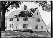
Comfort Starr House
The Comfort Starr House, located at 138 State St., Guilford, Connecticut, is a classic saltbox house with an added leanto . It is presumed that the original house was built between 1645 and 1646. The house derives its name from Comfort Starr who bought the house from the original builder, a...
(1645–46), is one of the oldest wooden framed private dwellings in Connecticut, and one of the few houses remaining of the original signers who settled Guilford.
Geography
According to the United States Census BureauUnited States Census Bureau
The United States Census Bureau is the government agency that is responsible for the United States Census. It also gathers other national demographic and economic data...
, the town has a total area of 49.7 square miles (128.7 km²), of which 47 square miles (121.7 km²) is land and 2.7 square miles (6.9 km² or 5.39%) is water.
The northwest side of Guilford is flanked by the Metacomet Ridge
Metacomet Ridge
The Metacomet Ridge, Metacomet Ridge Mountains, or Metacomet Range of southern New England, United States, is a narrow and steep fault-block mountain ridge known for its extensive cliff faces, scenic vistas, microclimate ecosystems, and communities of plants considered rare or endangered...
, a mountainous trap rock
Trap rock
Trap rock is a form of igneous rock that tends to form polygonal vertical fractures, most typically hexagonal, but also four to eight sided. The fracture pattern forms when magma of suitable chemical composition intrudes as a sill or extrudes as a thick lava flow, and slowly cools.Because of the...
ridgeline that stretches from Long Island Sound
Long Island Sound
Long Island Sound is an estuary of the Atlantic Ocean, located in the United States between Connecticut to the north and Long Island, New York to the south. The mouth of the Connecticut River at Old Saybrook, Connecticut, empties into the sound. On its western end the sound is bounded by the Bronx...
to nearly the Vermont
Vermont
Vermont is a state in the New England region of the northeastern United States of America. The state ranks 43rd in land area, , and 45th in total area. Its population according to the 2010 census, 630,337, is the second smallest in the country, larger only than Wyoming. It is the only New England...
border. Notable features of the Metacomet ridge in Guilford include Totoket Mountain
Totoket Mountain
Totoket Mountain, with a high point of above sea level, is a traprock massif with several distinct summits, located northeast of New Haven, Connecticut. It is part of the Metacomet Ridge that extends from Long Island Sound near New Haven, north through the Connecticut River Valley of...
; its most notable peak, Bluff Head; and two eastern high points on the Totoket Mountain ridge named East Sugarloaf and West Sugarloaf. The 50 miles (80.5 km) Mattabesett Trail
Mattabesett Trail
The Mattabesett Trail is a long, hook-shaped Blue-Blazed hiking trail in central Connecticut and a part of the newly designated New England National Scenic Trail. One half of the trail follows the high traprock ridges of the Metacomet Ridge, from Totoket Mountain in Guilford, Connecticut to...
traverses Bluff Head;, a shorter network of trails criss-cross the Sugarloafs. Guilford also contains the Westwoods Trail System which covers 39 miles (62.8 km) of trails on 1200 acres (4.9 km²) of land.
Principal communities
- Guilford Center
- Leete's Island
- North Guilford
- Nut Plains
- Sachem's Head (named after three PequotPequotPequot people are a tribe of Native Americans who, in the 17th century, inhabited much of what is now Connecticut. They were of the Algonquian language family. The Pequot War and Mystic massacre reduced the Pequot's sociopolitical influence in southern New England...
chiefs who were captured and decapitated there by MoheganMoheganThe Mohegan tribe is an Algonquian-speaking tribe that lives in the eastern upper Thames River valley of Connecticut. Mohegan translates to "People of the Wolf". At the time of European contact, the Mohegan and Pequot were one people, historically living in the lower Connecticut region...
s)
Other minor communities and geographic features in Guilford are: Guilford Lakes, Indian Cove, Old Quarry.
Demographics
Census
A census is the procedure of systematically acquiring and recording information about the members of a given population. It is a regularly occurring and official count of a particular population. The term is used mostly in connection with national population and housing censuses; other common...
of 2000, there were 21,398 people, 8,151 households, and 6,039 families residing in the town. The population density
Population density
Population density is a measurement of population per unit area or unit volume. It is frequently applied to living organisms, and particularly to humans...
was 454.8 people per square mile (175.6/km²). There were 8,724 housing units at an average density of 185.4 per square mile (71.6/km²). The racial makeup of the town was 96.04% White, 0.93% African American, 0.05% Native American, 1.65% Asian, 0.41% from other races
Race (United States Census)
Race and ethnicity in the United States Census, as defined by the Federal Office of Management and Budget and the United States Census Bureau, are self-identification data items in which residents choose the race or races with which they most closely identify, and indicate whether or not they are...
, and 0.93% from two or more races. Hispanic or Latino of any race were 2.13% of the population.
There were 8,151 households out of which 35.6% had children under the age of 18 living with them, 64.4% were married couples
Marriage
Marriage is a social union or legal contract between people that creates kinship. It is an institution in which interpersonal relationships, usually intimate and sexual, are acknowledged in a variety of ways, depending on the culture or subculture in which it is found...
living together, 7.2% had a female householder with no husband present, and 25.9% were non-families. 21.6% of all households were made up of individuals and 8.6% had someone living alone who was 65 years of age or older. The average household size was 2.59 and the average family size was 3.04.
In the town the population was spread out with 25.4% under the age of 18, 4.4% from 18 to 24, 26.2% from 25 to 44, 31.2% from 45 to 64, and 12.8% who were 65 years of age or older. The median age was 42 years. For every 100 females there were 92.8 males. For every 100 females age 18 and over, there were 89.5 males.
The median income for a household in the town was $76,843, and the median income for a family was $87,045 (these figures had risen to $90,026 and $104,852 respectively as of a 2007 estimate). Males had a median income of $60,623 versus $40,307 for females. The per capita income
Per capita income
Per capita income or income per person is a measure of mean income within an economic aggregate, such as a country or city. It is calculated by taking a measure of all sources of income in the aggregate and dividing it by the total population...
for the town was $37,161. About 2.3% of families and 3.1% of the population were below the poverty line, including 3.4% of those under age 18 and 3.8% of those age 65 or over.
| Voter Registration and Party Enrollment as of October 25, 2005 | |||||||||||||||||||||||||
|---|---|---|---|---|---|---|---|---|---|---|---|---|---|---|---|---|---|---|---|---|---|---|---|---|---|
| Party | Active Voters | Inactive Voters | Total Voters | Percentage |
Democratic Democratic Party (United States) The Democratic Party is one of two major contemporary political parties in the United States, along with the Republican Party. The party's socially liberal and progressive platform is largely considered center-left in the U.S. political spectrum. The party has the lengthiest record of continuous... |
4,275 | 82 | 4,357 | 27.69% |
Republican Republican Party (United States) The Republican Party is one of the two major contemporary political parties in the United States, along with the Democratic Party. Founded by anti-slavery expansion activists in 1854, it is often called the GOP . The party's platform generally reflects American conservatism in the U.S... |
3,837 | 85 | 3,922 | 24.92% |
Unaffiliated | 7,280 | 148 | 7,428 | 47.20% |
Minor Parties | 29 | 0 | 29 | 0.18% | |
| Total | 15,421 | 315 | 15,736 | 100% | |||||||||||||||||||||
List of town parks
The town government operates these parks:- Bittner Park — 123 acre (0.49776378 km²) of woodlands and 15 acres (60,702.9 m²) of playground, a lighted softball field (Cash Mitchell Field), baseball and soccer fields, jogging/walking path; trout trail; roller sports complex with a skate park, roller hockey and roller blading. Ice skating available in winter.
- Chaffinch Island — Picnic areas, short walking trails, salt marsh.
- Chittenden Park — Softball and soccer fields, bocce courts, picnicking, unsupervised beach area
- Jacobs Beach — Public swimming (salt water), playground, volleyball courts, picnicking; nonresidents may use the beach, but are charged a daily fee at the gate.
- Lake Quonnipaug — Public swimming, picnic area, small craft launch.
- Long Hill — 8 acres (32,374.9 m²) park with playing fields for baseball, football, soccer/lacrosse and field hockey
- Mill Pond — Lighted, supervised ice skating in winter; fishing
- Nut Plains — Lacrosse/soccer field
- Town Green — available for special events
Notable locations
- Bishop's OrchardsBishop's OrchardsBishop's Orchards is an agricultural operation in Guilford, Connecticut, that serves as a farm, retail market, tourist attraction and winery.Bishop's Orchards began operating as a family farm in 1871...
- Rothberg Institute For Childhood DiseasesRothberg Institute For Childhood DiseasesThe Rothberg Institute For Childhood Diseases is a non-profit organization dedicated to finding a cure for children suffering from Tuberous Sclerosis Complex, founded in 2002. It is responsible for the CommunityTSC distributed computing project....
- Sachem's Head Yacht ClubSachem's Head Yacht ClubThe Sachem's Head Yacht Club is a private yacht club located on the shore of Long Island Sound in Guilford, Connecticut near the Thimble Islands. It serves an active racing fleet and is a summer base for member families and juniors involved in sailing, swimming and tennis. The club was founded in...
- Guilford Green
- Westwoods
National Historic Places and other historic sites
Historic sites in or near Guilford, which may or may not be listed on the National Register of Historic PlacesNational Register of Historic Places
The National Register of Historic Places is the United States government's official list of districts, sites, buildings, structures, and objects deemed worthy of preservation...
, may or may not include:
- Acadian HouseAcadian House (Guilford, Connecticut)The Acadian House, a Connecticut saltbox house, was built around 1690 in Guilford, Connecticut. The house gets its name after the Acadians who resided there following the 1755 deportation....
. - Thomas Burgis II HouseThomas Burgis II HouseThomas Burgis II House is a historic house at 85 Boston Street in Guilford, Connecticut.It was built in 1735 and added to the National Register of Historic Places in 2000.-References:...
- Comfort Starr HouseComfort Starr HouseThe Comfort Starr House, located at 138 State St., Guilford, Connecticut, is a classic saltbox house with an added leanto . It is presumed that the original house was built between 1645 and 1646. The house derives its name from Comfort Starr who bought the house from the original builder, a...
- Dudleytown Historic DistrictDudleytown Historic DistrictThe Dudleytown Historic District is a historic district in Guilford, Connecticut. Known also as Clapboard Hill, it includes part or all of a neighborhood named Dudleytown....
- Jared Eliot House
- Falkner's Island Lighthouse
- Griswold House
- Guilford Historic Town Center
- Hyland-Wildman HouseHyland-Wildman HouseThe Hyland-Wildman House in Guilford, Connecticut is located with close proximity to Guilford's historic town center. Officially known as Hyland House, it is one of many historical landmarks near Guilford's town green and town center. The house is a red saltbox-shaped home built between 1690 and 1710...
- Pelatiah Leete House
- Meeting House Hill Historic District
- Elisha Pitkin House
- Route 146 Historic District
- Sabbathday House
- Henry Whitfield HouseHenry Whitfield HouseThe Henry Whitfield House is a historic house located at 248 Old Whitfield Street in Guilford, Connecticut. This house dates from 1639, having been built just before the town of Guilford was settled. The house, with its massive stone walls, also served as a fort. It was one of four stone houses...