
.gif)
Route 8 (New England)
Encyclopedia
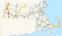
Route 8 is a multi-state north–south state highway
in the New England
region of the United States
, running from Bridgeport, Connecticut
, through Massachusetts
to Searsburg, Vermont
. Its number dates from 1922, when it was a New England Interstate Route, also known as the Stratford-Waterbury-North Adams Route (for the cities the original route connected). Most of the old route in Connecticut has been upgraded to a freeway and is a major transportation link between the cities of Bridgeport and Waterbury.
The highway has kept its number for most of its routing, and in these sections now exists as Connecticut Route 8, Massachusetts Route 8, and Vermont Route 8. North of Searsburg, VT, the old routing exists as part of Vermont Route 100
and all of Vermont Route 155
(which both used to be part of VT-8).
. It has junctions with the Merritt Parkway
in Trumbull and Interstate 84
in Waterbury. The freeway continues through the city of Torrington up to US 44 in Winsted
. North of Winsted, Route 8 becomes a minor rural road through Colebrook
into Massachusetts. The freeway portion of Route 8 is 58 miles (93.3 km) long.
 Massachusetts Route 8 crosses the border from Connecticut into Sandisfield, Massachusetts
. It runs for 66.6 miles (107.2 km) northward, through the western Massachusetts towns of Otis, Becket, Washington, Hinsdale, Dalton, Pittsfield, Lanesborough, Cheshire, Adams, North Adams and Clarksburg. The entire route in Massachusetts is in Berkshire County
.
An old alignment in North Adams is now the upper segment of Route 8A
.
, where a concurrency
with Vermont Route 100
begins at the Massachusetts state line. VT Routes 8 and 100 split in Readsboro, with VT Route 8 continuing north to end at Vermont Route 9 in Searsburg. (VT Route 100, the original alignment of Route 8, takes a more circuitous route, heading southeast and east from the split before turning north to intersect VT Route 9 in Wilmington.)
, running along the west bank of the lower Housatonic River
until Shelton
. The southern end of Route 8 was relocated in 1951 to its current Bridgeport terminus as part of the freeway upgrading. The old surface road is now parts of Route 113 and Route 110. North of Shelton, the old surface road (where it still exists) generally parallels the freeway, much of it still state-maintained.
In the late 1940s, a four-lane bypass was built south of North Adams, Massachusetts
and designated as Route 8A
. Around 1975, Routes 8 and 8A were swapped, with the original route now designated as Route 8A and the bypass route as Route 8.
Though the original Route 8 in Vermont did not run north of Wilmington, Route 8 was extended north to Londonderry by 1927 along present Vermont Route 100
, and by 1938 to Weston
and along Vermont Route 155
to Wallingford. This was still Route 8 in 1961, with Route 100 ending at Route 8 north of Weston. Route 100 was later extended south along Route 8 to the Massachusetts state line. The short piece of Route 8 between Weston and Wallingford became Vermont Route 155, and the Route 8 designation was assigned to its current alignment. (The piece of current Route 8 between Route 100 at Heartwellville and Route 9 at Searsburg had been unnumbered.)
State highway
State highway, state road or state route can refer to one of three related concepts, two of them related to a state or provincial government in a country that is divided into states or provinces :#A...
in the New England
New England
New England is a region in the northeastern corner of the United States consisting of the six states of Maine, New Hampshire, Vermont, Massachusetts, Rhode Island, and Connecticut...
region of the United States
United States
The United States of America is a federal constitutional republic comprising fifty states and a federal district...
, running from Bridgeport, Connecticut
Bridgeport, Connecticut
Bridgeport is the most populous city in the U.S. state of Connecticut. Located in Fairfield County, the city had an estimated population of 144,229 at the 2010 United States Census and is the core of the Greater Bridgeport area...
, through Massachusetts
Massachusetts
The Commonwealth of Massachusetts is a state in the New England region of the northeastern United States of America. It is bordered by Rhode Island and Connecticut to the south, New York to the west, and Vermont and New Hampshire to the north; at its east lies the Atlantic Ocean. As of the 2010...
to Searsburg, Vermont
Searsburg, Vermont
Searsburg is a town in Bennington County, Vermont, United States. The population was 96 at the 2000 census.Searsburg is the home of a six megawatt wind turbine farm owned by Green Mountain Power. The town officers have supported the electrical generating station consisting of multiple towers atop a...
. Its number dates from 1922, when it was a New England Interstate Route, also known as the Stratford-Waterbury-North Adams Route (for the cities the original route connected). Most of the old route in Connecticut has been upgraded to a freeway and is a major transportation link between the cities of Bridgeport and Waterbury.
The highway has kept its number for most of its routing, and in these sections now exists as Connecticut Route 8, Massachusetts Route 8, and Vermont Route 8. North of Searsburg, VT, the old routing exists as part of Vermont Route 100
Vermont Route 100
Vermont Route 100 is a north–south state highway in Vermont, United States. Running through the center of the state, it travels nearly the entire length of Vermont and is long...
and all of Vermont Route 155
Vermont Route 155
Vermont Route 155 is a north–south state highway in central Vermont, United States. It runs from Weston in the south to East Wallingford in the north. Much of the highway goes through the Green Mountain National Forest....
(which both used to be part of VT-8).
Connecticut
Connecticut Route 8 begins as a freeway in the city of Bridgeport co-signed with Route 25Route 25 (Connecticut)
Route 25 is a , primary state highway connecting the city of Bridgeport and the town of Brookfield in the U.S. state of Connecticut. Route 25 is a six-lane freeway from Bridgeport to northern Trumbull and a two-lane surface road the rest of the way to Brookfield.Route 25 was...
. It has junctions with the Merritt Parkway
Merritt Parkway
The Merritt Parkway is a historic limited-access parkway in Fairfield County, Connecticut. The parkway is known for its scenic layout, its uniquely styled signage, and the architecturally elaborate overpasses along the route. It is designated as a National Scenic Byway and is also listed in the...
in Trumbull and Interstate 84
Interstate 84 (east)
Interstate 84 is an Interstate Highway extending from Dunmore, Pennsylvania at an interchange with Interstate 81 to Sturbridge, Massachusetts, at an interchange with the Massachusetts Turnpike . I-84 has mile-log junction numbering in Pennsylvania; otherwise, exit numbers are roughly sequential...
in Waterbury. The freeway continues through the city of Torrington up to US 44 in Winsted
Winsted, Connecticut
Winsted is a census-designated place and an incorporated city in Litchfield County, Connecticut, United States. It is part of the town of Winchester, Connecticut. The population was 7,321 at the 2000 census.-History:...
. North of Winsted, Route 8 becomes a minor rural road through Colebrook
Colebrook, Connecticut
Colebrook is a town in Litchfield County, Connecticut, United States. The population was 1,471 at the 2000 census. Colebrook was named after Colebrooke, in the English county of Devon.-Geography:...
into Massachusetts. The freeway portion of Route 8 is 58 miles (93.3 km) long.
Massachusetts
Sandisfield, Massachusetts
Sandisfield is a town in Berkshire County, Massachusetts, United States. It is part of the Pittsfield, Massachusetts Metropolitan Statistical Area. The population was 824 at the 2000 census.- History :...
. It runs for 66.6 miles (107.2 km) northward, through the western Massachusetts towns of Otis, Becket, Washington, Hinsdale, Dalton, Pittsfield, Lanesborough, Cheshire, Adams, North Adams and Clarksburg. The entire route in Massachusetts is in Berkshire County
Berkshire County, Massachusetts
Berkshire County is a non-governmental county located on the western edge of the U.S. state of Massachusetts. As of the 2010 census, the population was 131,219. Its largest city and traditional county seat is Pittsfield...
.
An old alignment in North Adams is now the upper segment of Route 8A
Route 8A (Massachusetts)
Route 8A refers to two separate north–south state highways in western Massachusetts. Both sections are marked as "Route 8A" on guide signs and reassurance markers...
.
| County | Location | Mile | Roads intersected | Notes |
|---|---|---|---|---|
| Berkshire Berkshire County, Massachusetts Berkshire County is a non-governmental county located on the western edge of the U.S. state of Massachusetts. As of the 2010 census, the population was 131,219. Its largest city and traditional county seat is Pittsfield... |
Sandisfield Sandisfield, Massachusetts Sandisfield is a town in Berkshire County, Massachusetts, United States. It is part of the Pittsfield, Massachusetts Metropolitan Statistical Area. The population was 824 at the 2000 census.- History :... |
0.00 |  CT Route 8 CT Route 8 |
Southern terminus of Route 8, continues southbound into Colebrook, CT Colebrook, Connecticut Colebrook is a town in Litchfield County, Connecticut, United States. The population was 1,471 at the 2000 census. Colebrook was named after Colebrooke, in the English county of Devon.-Geography:... . |
| 4.1 |  Route 57 Route 57Massachusetts Route 57 Route 57 is an east–west Massachusetts state route that runs from Monterey to Agawam. The eastern 5.0 miles in Agawam is a freeway that runs from Route 187 to the route's eastern terminus at U.S. Route 5.- Route description :... |
120-yard overlap with Route 57 | ||
| Otis Otis, Massachusetts Otis is a town in Berkshire County, Massachusetts, United States. It is part of the Pittsfield, Massachusetts Metropolitan Statistical Area. The population was 1,365 at the 2000 census.... |
12.1 |   Route 23 East Route 23 East |
Southern terminus of Route 8/23 concurrency. | |
| 12.3 |  Route 23 West Route 23 West |
Northern terminus of Route 8/23 concurrency. | ||
| Becket Becket, Massachusetts Becket is a town in Berkshire County, Massachusetts, United States. It is part of the Pittsfield, Massachusetts Metropolitan Statistical Area. The population was 1,779 at the 2010 census.- History :... |
17.7 |  U.S. Route 20 U.S. Route 20U.S. Route 20 in Massachusetts The cross-country U.S. Route 20 runs its easternmost in the U.S. state of Massachusetts. The highway crosses the state border from New Lebanon, New York into Hancock, Massachusetts, and runs eastward into Boston, where it ends at Route 2 in Kenmore Square... West |
Western terminus of US-20/Route 8 concurrency. To  Mass Pike (I-90) Mass Pike (I-90)Massachusetts Turnpike The Massachusetts Turnpike is the easternmost stretch of Interstate 90. The Turnpike begins at the western border of Massachusetts in West Stockbridge connecting with the Berkshire Connector portion of the New York State Thruway... . |
|
| 22.9 | U.S. Route 20 U.S. Route 20 in Massachusetts The cross-country U.S. Route 20 runs its easternmost in the U.S. state of Massachusetts. The highway crosses the state border from New Lebanon, New York into Hancock, Massachusetts, and runs eastward into Boston, where it ends at Route 2 in Kenmore Square... East |
Western terminus of US-20/Route 8 concurrency. | ||
| Hinsdale Hinsdale, Massachusetts Hinsdale is a town in Berkshire County, Massachusetts, United States. It is part of the Pittsfield, Massachusetts Metropolitan Statistical Area... |
38.1 |  Route 143 Route 143Massachusetts Route 143 Route 143 is a 24.5 mile, 39.4 kilometer west–east state highway in the U.S. state of Massachusetts. Its western terminus is at Route 8 in Hinsdale, at the town's center. Its eastern terminus is at Route 9 near the village of Searsville in Williamsburg. At Worthington, the highway runs... |
Western terminus of Route 143. | |
| Dalton Dalton, Massachusetts Dalton is a town in Berkshire County, Massachusetts, United States. Dalton is the transition town between the urban and rural pieces of Berkshire County, Massachusetts. It is part of the Pittsfield, Massachusetts Metropolitan Statistical Area. The population was 6,892 at the 2000 census.- History... |
41.8 |  Route 8A(L) Route 8A(L) Route 9 East Route 9 East |
Southern terminus of Route 8A (L Segment). Eastern terminus of Route 8/9 concurrency. |
|
| Pittsfield Pittsfield, Massachusetts Pittsfield is the largest city and the county seat of Berkshire County, Massachusetts, United States. It is the principal city of the Pittsfield, Massachusetts Metropolitan Statistical Area which encompasses all of Berkshire County. Its area code is 413. Its ZIP code is 01201... |
44.1 | Route 9 West |
Western terminus of Route 8/9 concurrency. To  U.S. Route 7 U.S. Route 7U.S. Route 7 U.S. Route 7 is a north–south United States highway in western New England that runs for from Norwalk, Connecticut, to Highgate, Vermont. The highway's southern terminus is at Interstate 95 in Norwalk, Connecticut... /U.S. Route 20 U.S. Route 20 in Massachusetts The cross-country U.S. Route 20 runs its easternmost in the U.S. state of Massachusetts. The highway crosses the state border from New Lebanon, New York into Hancock, Massachusetts, and runs eastward into Boston, where it ends at Route 2 in Kenmore Square... . |
|
| Adams Adams, Massachusetts Adams is a town in Berkshire County, Massachusetts, United States. It is part of the Pittsfield, Massachusetts Metropolitan Statistical Area. The population was 8,485 at the 2010 census.-History:... |
56.3 |  Route 116 Route 116Massachusetts Route 116 Route 116 is a south–north state highway in Massachusetts. The route runs from Springfield through mill towns, college towns and rural towns, crossing the Connecticut River three times before finally ending in Adams.-Route description:... |
Northern terminus of Route 116. | |
| North Adams North Adams, Massachusetts North Adams is a city in Berkshire County, Massachusetts, United States. It is part of the Pittsfield, Massachusetts Metropolitan Statistical Area. The population was 13,708 as of the 2010 census, making it the least populous city in the state... |
59.5 | Route 8A(U) |
Southern terminus of Route 8A (U Segment). | |
| 62.3 |  Route 2 West Route 2 West |
Western terminus of Route 2/8 concurrency. | ||
| 62.4 | Route 8A(U) |
Northern terminus of Route 8A (U Segment). | ||
| 63.1 | Route 2 East |
Eastern terminus of Route 2/8 concurrency. To Mohawk Trail Mohawk Trail - External links :* *... . |
||
| Clarksburg Clarksburg, Massachusetts Clarksburg is a town in Berkshire County, Massachusetts, United States. It is part of the Pittsfield, Massachusetts Metropolitan Statistical Area... |
66.58 |  VT Route 8 VT Route 8 VT Route 100 VT Route 100Vermont Route 100 Vermont Route 100 is a north–south state highway in Vermont, United States. Running through the center of the state, it travels nearly the entire length of Vermont and is long... |
Northern terminus of Route 8, continues northbound into Stamford, VT. Southern terminus of VT Route 100. |
Vermont
Vermont Route 8 begins in Stamford, VermontStamford, Vermont
Stamford is a town in Bennington County, Vermont, United States. The population was 813 at the 2000 census.-Geography:Stamford is located near the southwestern corner of Vermont, on the Massachusetts state line. To the south of Stamford lie Clarksburg, Massachusetts and Florida, Massachusetts...
, where a concurrency
Concurrency (road)
A concurrency, overlap, or coincidence in a road network is an instance of one physical road bearing two or more different highway, motorway, or other route numbers...
with Vermont Route 100
Vermont Route 100
Vermont Route 100 is a north–south state highway in Vermont, United States. Running through the center of the state, it travels nearly the entire length of Vermont and is long...
begins at the Massachusetts state line. VT Routes 8 and 100 split in Readsboro, with VT Route 8 continuing north to end at Vermont Route 9 in Searsburg. (VT Route 100, the original alignment of Route 8, takes a more circuitous route, heading southeast and east from the split before turning north to intersect VT Route 9 in Wilmington.)
History
The original Route 8 began in Stratford, ConnecticutStratford, Connecticut
Stratford is a town in Fairfield County, Connecticut, United States, located on Long Island Sound at the mouth of the Housatonic River. It was founded by Puritans in 1639....
, running along the west bank of the lower Housatonic River
Housatonic River
The Housatonic River is a river, approximately long, in western Massachusetts and western Connecticut in the United States. It flows south to southeast, and drains about of southwestern New England into Long Island Sound...
until Shelton
Shelton, Connecticut
Shelton is a city in Fairfield County, Connecticut, United States. The population was 39,559 at the 2010 census.-Origins:Shelton was settled by the English as part of the town of Stratford, Connecticut, in 1639...
. The southern end of Route 8 was relocated in 1951 to its current Bridgeport terminus as part of the freeway upgrading. The old surface road is now parts of Route 113 and Route 110. North of Shelton, the old surface road (where it still exists) generally parallels the freeway, much of it still state-maintained.
In the late 1940s, a four-lane bypass was built south of North Adams, Massachusetts
North Adams, Massachusetts
North Adams is a city in Berkshire County, Massachusetts, United States. It is part of the Pittsfield, Massachusetts Metropolitan Statistical Area. The population was 13,708 as of the 2010 census, making it the least populous city in the state...
and designated as Route 8A
Route 8A (Massachusetts)
Route 8A refers to two separate north–south state highways in western Massachusetts. Both sections are marked as "Route 8A" on guide signs and reassurance markers...
. Around 1975, Routes 8 and 8A were swapped, with the original route now designated as Route 8A and the bypass route as Route 8.
Though the original Route 8 in Vermont did not run north of Wilmington, Route 8 was extended north to Londonderry by 1927 along present Vermont Route 100
Vermont Route 100
Vermont Route 100 is a north–south state highway in Vermont, United States. Running through the center of the state, it travels nearly the entire length of Vermont and is long...
, and by 1938 to Weston
Weston, Vermont
Weston is a town in Windsor County, Vermont, United States. The population was 630 at the 2000 census. Home to the Weston Playhouse Theatre Company, it includes the villages of Weston and the Island.-History:...
and along Vermont Route 155
Vermont Route 155
Vermont Route 155 is a north–south state highway in central Vermont, United States. It runs from Weston in the south to East Wallingford in the north. Much of the highway goes through the Green Mountain National Forest....
to Wallingford. This was still Route 8 in 1961, with Route 100 ending at Route 8 north of Weston. Route 100 was later extended south along Route 8 to the Massachusetts state line. The short piece of Route 8 between Weston and Wallingford became Vermont Route 155, and the Route 8 designation was assigned to its current alignment. (The piece of current Route 8 between Route 100 at Heartwellville and Route 9 at Searsburg had been unnumbered.)
See also
- Route 8A (Massachusetts)Route 8A (Massachusetts)Route 8A refers to two separate north–south state highways in western Massachusetts. Both sections are marked as "Route 8A" on guide signs and reassurance markers...
- The lower segment of Route 8A is an alternate route beginning at Dalton, MassachusettsDalton, MassachusettsDalton is a town in Berkshire County, Massachusetts, United States. Dalton is the transition town between the urban and rural pieces of Berkshire County, Massachusetts. It is part of the Pittsfield, Massachusetts Metropolitan Statistical Area. The population was 6,892 at the 2000 census.- History...
towards Whitingham, VermontWhitingham, VermontWhitingham is a town in Windham County, Vermont, United States. The town was named for Nathan Whiting, a landholder. The population was 1,298 at the 2000 census. Whitingham is the birthplace of Brigham Young, the second President of The Church of Jesus Christ of Latter-day Saints and founder of... - Vermont Route 8AVermont Route 8AVermont Route 8A is a state highway in Windham County, Vermont, United States. It is the northward continuation of Massachusetts' Route 8A, running entirely in the town of Whitingham. The road is numbered as a state route but is maintained by the town of Whitingham as a class-2 town highway...