

New York State Route 25
Encyclopedia
New York State Route 25 (NY 25) is an east–west state highway
in downstate New York in the United States. The route extends for just over 105 miles (169 km) from east midtown Manhattan
in New York City to the Cross Sound Ferry
terminal at Orient Point on the end of Long Island
's North Fork
. NY 25 is carried from Manhattan
to Queens
by way of the double-decked Queensboro Bridge
over the East River
. The bridge is the only double-decked portion of NY 25.
NY 25 has many names. In the borough
of Queens
, it is called Queens Boulevard
, Hillside Avenue and finally Braddock Avenue. In Nassau
and western Suffolk
counties, Route 25 is referred to as Jericho Turnpike. Moving east, the highway changes names to Main Street in Smithtown
, Middle Country Road in central Suffolk, Main Street again in Riverhead
and finally Main Road in eastern Suffolk.
Two alternate routings exist bearing the designation "Truck Route 25", both along the North Fork of Long Island
. One is between Laurel
and Mattituck
(or Aldrich Lane), and the other is directly within Greenport itself along Moore's Lane.
in Manhattan
, at the western end of the double-decked Queensboro Bridge
crossing over the East River
and Roosevelt Island
. East of the bridge, Route 25 becomes Queens Boulevard
at the intersection with NY 25A
, in the Long Island City section of the borough of Queens
. Queens
and Queensboro plazas are based on this section of the road.
In Long Island City, Route 25 runs southeast beneath the elevated tracks of the IRT Flushing Line
. At Thompson Avenue, the route turns to run eastward as the multi-lane divided
Queens Boulevard. In Woodside
, Route 25 meets Interstate 278 at exit 39. In Corona, the road intersects Interstate 495
and the northern terminus of Woodhaven Boulevard.
Outside of Rego Park, Route 25 turns slightly southeast towards Forest Hills and Jamaica. In Kew Gardens, the route is connected to the westbound and eastbound roadways of Union Turnpike
and passes over the Jackie Robinson Parkway
without access. Near Jamaica, the road meets Interstate 678 at exit 9, a partial interchange. Three blocks southeast of I-678, Route 25 turns east and is known as Hillside Avenue. This roadway of Route 25 is undivided but has several lanes in the Jamaica-Hollis area. In Queens Village, the route connects with both Interstate 295
and NY 24
at an interchange that serves as NY 24's western end and I-295's southern terminus. East of I-295, Route 25 intersects the western terminus of NY 25B
; 25 turns southeast onto Braddock Avenue while 25B continues as Hillside Avenue.
 In Bellerose
, the roadway passes over the Cross Island Parkway
and turns east onto Jericho Turnpike. This section until just before 257th Street is the border between the Bellerose and Floral Park
neighborhoods of Queens to the north and the villages of Bellerose
and Floral Park
in Nassau County
to the south. The westbound lanes are in New York City, while the eastbound lanes are in Nassau County. Throughout most of its route in New York City, Route 25 is one of the most important to commuters in the borough of Queens.
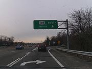
. Route 25 intersects with the Long Island Expressway once again in Jericho
. State routes 106
and 107
interchange with Route 25 in downtown Jericho, however the exit is not numbered.
The northern end of the Seaford-Oyster Bay Expressway (NY 135
) comes at Route 25 in Syosset
. NY 110
intersects at the 32.76 miles (52.72 km) mark, in South Huntington
. NY 454
begins at an intersection with Route 25 in Commack
. Just after the 454 intersection, NY 25 meets the Sunken Meadow State Parkway
by way of an interchange. State Route 25A, a spur of Route 25, becomes concurrent with Route 25 in Smithtown
. In Village of the Branch, Route 25A leaves to the north when NY 111
intersects from the south. New York State Bicycle Route 25 also begins along NY 25A at this intersection.
NY 347
intersects at 47.93 miles (77.14 km) in Nesconset
. In Coram
, Route 25 intersects with NY 112
. Route 25A comes to an end at Route 25 in Calverton
, and New York State Bicycle Route 25 joins NY 25 on its way to Orient Point, with occasional diversions in Riverhead, Aquebogue, and Greenport. Four miles (6 km) later, NY 25 encounters the Long Island Expressway one final time at another interchange. 20 miles (32 km) later, in Greenport
, Route 25 intersects with Route 114 at its northern terminus. Route 25 continues on the northeastern end of Long Island for the final ten miles (16 km). Route 25 enters Orient
and comes to an end at the Orient Point Ferry Landing
. An attraction along Route 25 in Orient is Orient Beach State Park
.
 NY 25 was assigned in the mid-1920s along all of what is now NY 25A
east of the New York City line and its current alignment from the modern east end of NY 25A to Greenport
. At the time, the section of modern NY 25 between the New York City line and Smithtown
was state-maintained but unnumbered. It was designated as NY 25A ca. 1927. In the late 1920s, NY 25 was realigned to follow Jericho Turnpike and Middle Country Road between Smithtown and Riverhead
while its former alignment to the north became part of NY 25A. In the 1930 renumbering of state highways in New York, the routings of NY 25 and NY 25A were flipped west of Smithtown, placing both routes on their current alignments. NY 25 was extended east to Orient Point ca. 1932.
NY 25 was one of several routes that was extended west into New York City in mid-December 1934 when the city signed routes within its limits for the first time. The route followed Jericho Turnpike, Braddock Avenue, Springfield Boulevard, Horace Harding Boulevard, and several smaller streets (including Corona, Woodside, and Skillman Avenues) westward to Queens Boulevard
, then part of NY 24
. NY 25 joined NY 24 here, overlapping NY 24 (and NY 25A
west of Northern Boulevard) along Queens Boulevard and across the Queensboro Bridge
into Manhattan
. The three routes continued west for several more blocks along 2nd Avenue and 57th Street
to Park Avenue
(then NY 22
and NY 100
), where NY 24, NY 25, and NY 25A all ended. At the time, the segment of modern NY 25 between Skillman Avenue and 212th Street was part of NY 24.
The overlaps with both NY 24 and NY 25A into Manhattan were eventually eliminated. In the mid-1940s, NY 24 was realigned to enter Manhattan by way of the Queens–Midtown Tunnel. As a result, NY 24 now left NY 25 at what is now exit 36 on the Brooklyn–Queens Expressway. The overlap with NY 25A was removed by 1952 after that route was truncated to the intersection of Northern and Queens Boulevards. NY 25 continued to extend into Manhattan until the mid-1960s when NY 22 was truncated to end in the North Bronx
. NY 25 was truncated to end in Queens as a result. It was reextended across the Queensboro Bridge on January 1, 1970, to a new terminus at FDR Drive.
. NY 25 went unchanged until January 1, 1970, when NY 24 was truncated to begin at the junction of 212th Street and Hillside Avenue. NY 24's former alignment along Queens Boulevard and Hillside Avenue became part of a realigned NY 25, which also used a previously unnumbered segment of Hillside Avenue between 212th Street and Braddock Avenue.
From 1920 to 2005, the section of NY 25 that forms the border between New York City and Nassau County was simultaneously named Jamaica Avenue
on the westbound (Queens, New York City) side and Jericho Turnpike on the eastbound (Nassau County) side. Some map makers only showed one of the names. The confusion ended when the road wholly entered Nassau County and thus became Jericho Turnpike in both directions. Similarly, both sides of the road west of Braddock Avenue (where NY 25 splits off to the northwest) were known as Jamaica Avenue even though the south side is still the Nassau County border until 225th Street. Legislation renaming the westbound side of NY 25 between Braddock Avenue and the Nassau County line as Jericho Turnpike was signed into law by New York City Mayor Michael Bloomberg
on June 6, 2005, and took effect on September 4.
, Old Jericho Turnpike parallels the current road from a point east of the NY 106
–NY 107
interchange and Marian Lane, where the old alignment merges with the current NY 25. Smithtown contains a former segment in the vicinity of the Nissequogue River
with a bridge and former right-of-way that still exists today. In Coram
, an old alignment of Middle Country Road (NY 25) extends from east of Paul's Path to Grant Smith Road. The road, however, is discontinuous at NY 112
. At Middle Island
, a former segment of Middle Country Road exists east of Church Lane and north of Bartlett Pond and runs to Robin Drive in Middle Island, where it rejoins NY 25. Another former segment used to dip south to avoid a small lake to the north. A small segment of the road remains intact as Old Middle Country Road from Picaso Way to Woodville Road. Prior to the construction of Picaso Way and the cluster developments it leads to, this section of Old Middle Country Road connected to the existing section at its west end, the stub of which can still be found.
Near Riverhead
, Middle Country Road once followed a parallel roadway to the south of the current roadway between River Road and Forge Road. Although some of this section has been dismantled, a portion still exists as modern Forge Road from the Peconic River Bridge to Kroemer Avenue. In Mattituck
, an old alignment of Main Road (NY 25) exists as Old Main Road from Gray Avenue to west of Sigsbee Road. Southwest of Southold
, Main Road originally followed the length of Lower Road and Ackerly Pond Lane between Lower Road and Main Road. To the northeast of the community, another former segment remains intact as Old Main Road between Budd's Pond and Mill Creek to Hashamomuck Pond.
East of Greenport
, a former alignment of Main Road is located between the creek from Silver Lake and Silvermere Road. In Orient
, two former routings of Main Road exist, both in the vicinity of Bight Road. The first, a loop connecting Grandview Drive to NY 25, is located west of Bight Road. The second, a loop providing access to Whalers Road from NY 25, is west of Charles Rose Airport.
(NYSDOT) wanted to install frontage roads along a divided Route 25 between Nesconset and Lake Grove as part of a proposed upgrade of NY 347
into a limited-access highway.
In the 1960s and 1970s, NYSDOT wanted to realign both Route 112
and Route 25 in Coram. The realignment and widening of NY 25 was to take place between NY 112 and Winfield Davis Road.
State highway
State highway, state road or state route can refer to one of three related concepts, two of them related to a state or provincial government in a country that is divided into states or provinces :#A...
in downstate New York in the United States. The route extends for just over 105 miles (169 km) from east midtown Manhattan
Manhattan
Manhattan is the oldest and the most densely populated of the five boroughs of New York City. Located primarily on the island of Manhattan at the mouth of the Hudson River, the boundaries of the borough are identical to those of New York County, an original county of the state of New York...
in New York City to the Cross Sound Ferry
Cross Sound Ferry
Cross Sound Ferry is a passenger and road vehicle ferry service operating between New London, Connecticut and Orient, Long Island, New York. The service is privately owned and operated by Cross Sound Ferry Services, Inc., headquartered in New London...
terminal at Orient Point on the end of Long Island
Long Island
Long Island is an island located in the southeast part of the U.S. state of New York, just east of Manhattan. Stretching northeast into the Atlantic Ocean, Long Island contains four counties, two of which are boroughs of New York City , and two of which are mainly suburban...
's North Fork
North Fork, Suffolk County, New York
The North Fork is a 30-mile-long peninsula in the northeast part of Suffolk County, New York, roughly parallel with an even longer peninsula known as the South Fork...
. NY 25 is carried from Manhattan
Manhattan
Manhattan is the oldest and the most densely populated of the five boroughs of New York City. Located primarily on the island of Manhattan at the mouth of the Hudson River, the boundaries of the borough are identical to those of New York County, an original county of the state of New York...
to Queens
Queens
Queens is the easternmost of the five boroughs of New York City. The largest borough in area and the second-largest in population, it is coextensive with Queens County, an administrative division of New York state, in the United States....
by way of the double-decked Queensboro Bridge
Queensboro Bridge
The Ed Koch Queensboro Bridge, also known as the 59th Street Bridge – because its Manhattan end is located between 59th and 60th Streets – or simply the Queensboro Bridge, is a cantilever bridge over the East River in New York City that was completed in 1909...
over the East River
East River
The East River is a tidal strait in New York City. It connects Upper New York Bay on its south end to Long Island Sound on its north end. It separates Long Island from the island of Manhattan and the Bronx on the North American mainland...
. The bridge is the only double-decked portion of NY 25.
NY 25 has many names. In the borough
Borough (New York City)
New York City, one of the largest cities in the world, is composed of five boroughs. Each borough now has the same boundaries as the county it is in. County governments were dissolved when the city consolidated in 1898, along with all city, town, and village governments within each county...
of Queens
Queens
Queens is the easternmost of the five boroughs of New York City. The largest borough in area and the second-largest in population, it is coextensive with Queens County, an administrative division of New York state, in the United States....
, it is called Queens Boulevard
Queens Boulevard
Queens Boulevard is a major thoroughfare in the New York City boroughs of Manhattan and Queens connecting communities from Midtown Manhattan to Jamaica...
, Hillside Avenue and finally Braddock Avenue. In Nassau
Nassau County, New York
Nassau County is a suburban county on Long Island, east of New York City in the U.S. state of New York, within the New York Metropolitan Area. As of the 2010 census, the population was 1,339,532...
and western Suffolk
Suffolk County, New York
Suffolk County is a county located in the U.S. state of New York on the eastern portion of Long Island. As of the 2010 census, the population was 1,493,350. It was named for the county of Suffolk in England, from which its earliest settlers came...
counties, Route 25 is referred to as Jericho Turnpike. Moving east, the highway changes names to Main Street in Smithtown
Smithtown, New York
As of the census of 2000, there were 115,715 people, 38,487 households, and 31,482 families residing in the town. The population density was 2,159.9 people per square mile . There were 39,357 housing units at an average density of 734.6 per square mile...
, Middle Country Road in central Suffolk, Main Street again in Riverhead
Riverhead (town), New York
The town of Riverhead is in Suffolk County, New York, on the north shore of Long Island. The population was 33,506 at the 2010 census. The name signifies that the mouth of the Peconic River is in this town...
and finally Main Road in eastern Suffolk.
Two alternate routings exist bearing the designation "Truck Route 25", both along the North Fork of Long Island
Long Island
Long Island is an island located in the southeast part of the U.S. state of New York, just east of Manhattan. Stretching northeast into the Atlantic Ocean, Long Island contains four counties, two of which are boroughs of New York City , and two of which are mainly suburban...
. One is between Laurel
Laurel, New York
Laurel is a census-designated place roughly corresponding to the hamlet in Suffolk County, New York, United States. It is in the towns of Southold and Riverhead. The population was 1,188 at the 2000 census.- History :...
and Mattituck
Mattituck, New York
Mattituck is a census-designated place in Suffolk County, New York, United States. The population was 4,198 at the 2000 census.Mattituck CDP roughly corresponds to the hamlet by the same name in the town of Southold.- History :...
(or Aldrich Lane), and the other is directly within Greenport itself along Moore's Lane.
New York City
Route 25 begins near Second AvenueSecond Avenue (Manhattan)
Second Avenue is an avenue on the East Side of the New York City borough of Manhattan extending from Houston Street at its south end to the Harlem River Drive at 128th Street at its north end. A one-way street, vehicular traffic runs only downtown. A bicycle lane in the left hand portion from 55th...
in Manhattan
Manhattan
Manhattan is the oldest and the most densely populated of the five boroughs of New York City. Located primarily on the island of Manhattan at the mouth of the Hudson River, the boundaries of the borough are identical to those of New York County, an original county of the state of New York...
, at the western end of the double-decked Queensboro Bridge
Queensboro Bridge
The Ed Koch Queensboro Bridge, also known as the 59th Street Bridge – because its Manhattan end is located between 59th and 60th Streets – or simply the Queensboro Bridge, is a cantilever bridge over the East River in New York City that was completed in 1909...
crossing over the East River
East River
The East River is a tidal strait in New York City. It connects Upper New York Bay on its south end to Long Island Sound on its north end. It separates Long Island from the island of Manhattan and the Bronx on the North American mainland...
and Roosevelt Island
Roosevelt Island
Roosevelt Island, known as Welfare Island from 1921 to 1973, and before that Blackwell's Island, is a narrow island in the East River of New York City. It lies between the island of Manhattan to its west and the borough of Queens to its east...
. East of the bridge, Route 25 becomes Queens Boulevard
Queens Boulevard
Queens Boulevard is a major thoroughfare in the New York City boroughs of Manhattan and Queens connecting communities from Midtown Manhattan to Jamaica...
at the intersection with NY 25A
New York State Route 25A
New York State Route 25A is a state highway on Long Island in New York in the United States. It serves as the main east–west route for most of the North Shore of Long Island, running from the Queens Midtown Tunnel in the New York City borough of Queens at its western terminus to...
, in the Long Island City section of the borough of Queens
Queens
Queens is the easternmost of the five boroughs of New York City. The largest borough in area and the second-largest in population, it is coextensive with Queens County, an administrative division of New York state, in the United States....
. Queens
Queens Plaza, Queens
Queens Plaza is a plaza located on Queens Boulevard, between North and South Plaza streets, in Long Island City, Queens. The plaza is overlapped by an elevated railway transit , with the Queensboro Bridge starting on the eastern side...
and Queensboro plazas are based on this section of the road.
In Long Island City, Route 25 runs southeast beneath the elevated tracks of the IRT Flushing Line
IRT Flushing Line
The Flushing Line is a rapid transit route of the New York City Subway system, operated as part of the IRT Division and designated the 7 route...
. At Thompson Avenue, the route turns to run eastward as the multi-lane divided
Divided Highway
Divided Highway is a compilation album by American rock band The Doobie Brothers, released in 2003. . All tracks are taken from the albums Cycles and Brotherhood .-Track listing:...
Queens Boulevard. In Woodside
Woodside, Queens
Woodside is a neighborhood in the western portion of the New York City borough of Queens. It is bordered on the south by Maspeth, on the north by Astoria, on the west by Sunnyside and on the east by Elmhurst and Jackson Heights. Some areas are widely residential and very quiet, while others are...
, Route 25 meets Interstate 278 at exit 39. In Corona, the road intersects Interstate 495
Interstate 495 (New York)
Interstate 495 is an auxiliary Interstate Highway on Long Island in New York in the United States. The route extends for from the western portal of the Queens-Midtown Tunnel in the New York City borough of Manhattan to County Route 58 in Riverhead, Suffolk County...
and the northern terminus of Woodhaven Boulevard.
Outside of Rego Park, Route 25 turns slightly southeast towards Forest Hills and Jamaica. In Kew Gardens, the route is connected to the westbound and eastbound roadways of Union Turnpike
Union Turnpike (New York)
Union Turnpike is a thoroughfare stretching across central and eastern Queens in New York City. It runs from Myrtle Avenue in Glendale to Marcus Avenue in North New Hyde Park, about a mile into Nassau County, New York. Initially designed as a toll road, it takes a straight-arrow path from Kew...
and passes over the Jackie Robinson Parkway
Jackie Robinson Parkway
The Jackie Robinson Parkway is a parkway in the New York City boroughs of Brooklyn and Queens. The western terminus of the parkway is at Jamaica Avenue in the Brooklyn neighborhood of East New York. It runs through Highland Park, along the north side of Ridgewood Reservoir, and through Forest Park...
without access. Near Jamaica, the road meets Interstate 678 at exit 9, a partial interchange. Three blocks southeast of I-678, Route 25 turns east and is known as Hillside Avenue. This roadway of Route 25 is undivided but has several lanes in the Jamaica-Hollis area. In Queens Village, the route connects with both Interstate 295
Interstate 295 (New York)
Interstate 295 is a connector route within New York City. Measuring 9.10 miles in length, I-295 travels from the Bruckner Interchange, a junction with I-95/I-278/I-678 in The Bronx, across the toll Throgs Neck Bridge to the Grand Central Parkway in Queens...
and NY 24
New York State Route 24
New York State Route 24 is an east–west state highway on Long Island in New York in the United States. The route is split into two segments, with the longest and westernmost of the two extending from Interstate 295 and NY 25 in the Queens Village section of the New York City...
at an interchange that serves as NY 24's western end and I-295's southern terminus. East of I-295, Route 25 intersects the western terminus of NY 25B
New York State Route 25B
New York State Route 25B is a 7.25 mile long east–west state highway located on Long Island in the U.S. state of New York. The western terminus of the route is at NY 25 in Queens. The eastern terminus is at an interchange with NY 25 in Westbury...
; 25 turns southeast onto Braddock Avenue while 25B continues as Hillside Avenue.
Bellerose, Queens
Bellerose, also called Bellerose Manor, is a neighborhood on the eastern edge of the New York City borough of Queens, near the border with Nassau County. It is sometimes referred to as Bellerose Manor, to distinguish it from the adjacent Bellerose Village and Bellerose Terrace in Nassau County,...
, the roadway passes over the Cross Island Parkway
Cross Island Parkway
Cross Island Parkway, also known as the 100th Infantry Division Parkway, is a parkway within New York State. The parkway is a part of the Belt Parkway system that runs along the perimeter of the borough of Queens in New York City...
and turns east onto Jericho Turnpike. This section until just before 257th Street is the border between the Bellerose and Floral Park
Floral Park, Queens
Floral Park is a neighborhood in the New York City borough of Queens. It is adjacent to the Village of Floral Park, which is in Nassau County. It may be distinguished from the latter by the use of the designation "North Floral Park". The neighborhood is part of Queens Community Board 13.Union...
neighborhoods of Queens to the north and the villages of Bellerose
Bellerose, New York
Bellerose is a village in Nassau County, New York, in the United States. The population was 1,193 at the 2010 census.Bellerose is in the town of Hempstead near the western county line.- History :...
and Floral Park
Floral Park, New York
Floral Park is an incorporated village in Nassau County, New York, United States, on Long Island. The population as of the US Census of 2010 is 15,863. The village is at the western border of Nassau County, and is located in both the Town of Hempstead and the Town of North Hempstead...
in Nassau County
Nassau County, New York
Nassau County is a suburban county on Long Island, east of New York City in the U.S. state of New York, within the New York Metropolitan Area. As of the 2010 census, the population was 1,339,532...
to the south. The westbound lanes are in New York City, while the eastbound lanes are in Nassau County. Throughout most of its route in New York City, Route 25 is one of the most important to commuters in the borough of Queens.
Long Island east of New York City
State Route 25B and Hillside Avenue merge into Route 25 in Mineola. Route 25 continues as a divided highway again and parallels the Northern State Parkway along the northern portion of Long IslandLong Island
Long Island is an island located in the southeast part of the U.S. state of New York, just east of Manhattan. Stretching northeast into the Atlantic Ocean, Long Island contains four counties, two of which are boroughs of New York City , and two of which are mainly suburban...
. Route 25 intersects with the Long Island Expressway once again in Jericho
Jericho, New York
Jericho is a hamlet in Nassau County, New York on the North Shore of Long Island. As of the United States 2010 Census, the CDP population was 13,567. The area is served by the Jericho Union Free School District, the boundaries of which differ somewhat from those of the hamlet...
. State routes 106
New York State Route 106
New York State Route 106 is a state highway in New York, running from NY 105 in North Bellmore to Oyster Bay. It runs through the Towns of Hempstead and Oyster Bay, including the hamlets of East Meadow, Levittown, Hicksville, Jericho, and East Norwich and the Villages of Brookville and...
and 107
New York State Route 107
New York State Route 107 is a state highway located entirely within Nassau County, New York, in the United States. It runs from Merrick Road in Massapequa to Mill Street and Brewster Avenue in the city of Glen Cove near City Hall...
interchange with Route 25 in downtown Jericho, however the exit is not numbered.
The northern end of the Seaford-Oyster Bay Expressway (NY 135
New York State Route 135
New York State Route 135 is a state highway in eastern Nassau County, New York, United States. The route is a limited-access highway that connects Seaford with Syosset. The highway runs from Merrick Road in Seaford to NY 25 in Syosset...
) comes at Route 25 in Syosset
Syosset, New York
Syosset is a hamlet in Nassau County, New York, in the northeastern section of Town of Oyster Bay near the North Shore of Long Island. The population was 18,829 at the 2010 census...
. NY 110
New York State Route 110
New York State Route 110 is a major north–south state highway along the western border of Suffolk County, New York. It runs between the Village of Amityville in the Town of Babylon and Halesite in the Town of Huntington...
intersects at the 32.76 miles (52.72 km) mark, in South Huntington
South Huntington, New York
South Huntington is a hamlet in Suffolk County, New York, United States. The population was 9,465 at the 2000 census....
. NY 454
New York State Route 454
New York State Route 454 , also known as the Suffolk County Veterans' Memorial Highway, is a east–west divided highway in western and central Suffolk County on Long Island in New York. It spans from NY 25 in Commack to NY 27 north of Patchogue...
begins at an intersection with Route 25 in Commack
Commack, New York
Commack is a census-designated place that roughly corresponds to the hamlet by the same name in the towns of Huntington and Smithtown in Suffolk County, New York, United States on Long Island...
. Just after the 454 intersection, NY 25 meets the Sunken Meadow State Parkway
Sunken Meadow State Parkway
The Sunken Meadow State Parkway is a long north–south parkway on Long Island in New York. All six miles of the parkway are located in the Suffolk County town of Smithtown. The southern terminus of the route is at the Northern State Parkway, where it continues southward as the Sagtikos...
by way of an interchange. State Route 25A, a spur of Route 25, becomes concurrent with Route 25 in Smithtown
Smithtown, New York
As of the census of 2000, there were 115,715 people, 38,487 households, and 31,482 families residing in the town. The population density was 2,159.9 people per square mile . There were 39,357 housing units at an average density of 734.6 per square mile...
. In Village of the Branch, Route 25A leaves to the north when NY 111
New York State Route 111
New York State Route 111 is a state highway located in Suffolk County, New York, in the United States. It runs north and south through the towns of Islip and Smithtown between NY 27A in the town seat of Islip and the east end of the NY 25 and NY 25A concurrency in Smithtown's...
intersects from the south. New York State Bicycle Route 25 also begins along NY 25A at this intersection.
NY 347
New York State Route 347
New York State Route 347 is an east–west state highway located in Suffolk County, New York, in the United States. It connects the Northern State Parkway in Hauppauge to NY 25A in Mount Sinai. The route serves as a southern bypass of Smithtown and as a direct link between Nesconset and...
intersects at 47.93 miles (77.14 km) in Nesconset
Nesconset, New York
Nesconset is a census-designated place in Suffolk County, Long Island, New York, United States. The population was 11,992 at the 2000 census.-Geography:Nesconset is located at ....
. In Coram
Coram, New York
As of the 2000 census, 34,923 people, 12,530 households, and 9,121 families resided in the CDP. The population density was 2,532.1 per square mile . There were 12,880 housing units at an average density of 933.9/sq mi...
, Route 25 intersects with NY 112
New York State Route 112
New York State Route 112 is a New York state highway, entirely within the Town of Brookhaven in Suffolk County. It runs from Montauk Highway, formerly part of NY 27A, in the village of Patchogue to NY 25A in Port Jefferson Station. It is known locally as Medford Ave in Patchogue...
. Route 25A comes to an end at Route 25 in Calverton
Calverton, New York
Calverton is a hamlet in Suffolk County, New York, United States. The population was 5,704 at the 2000 census.The community is on the border of the Town of Riverhead and the Town of Brookhaven.-History:...
, and New York State Bicycle Route 25 joins NY 25 on its way to Orient Point, with occasional diversions in Riverhead, Aquebogue, and Greenport. Four miles (6 km) later, NY 25 encounters the Long Island Expressway one final time at another interchange. 20 miles (32 km) later, in Greenport
Greenport, Suffolk County, New York
Greenport is a village in Suffolk County, New York, United States. It is located on the north fork of Long Island. The population was 2,048 at the 2000 census....
, Route 25 intersects with Route 114 at its northern terminus. Route 25 continues on the northeastern end of Long Island for the final ten miles (16 km). Route 25 enters Orient
Orient, New York
Orient is a census-designated place in Suffolk County, New York, United States. The CDP's population was 709 at the 2000 census.Orient and Orient Point are used almost interchangeably...
and comes to an end at the Orient Point Ferry Landing
Cross Sound Ferry
Cross Sound Ferry is a passenger and road vehicle ferry service operating between New London, Connecticut and Orient, Long Island, New York. The service is privately owned and operated by Cross Sound Ferry Services, Inc., headquartered in New London...
. An attraction along Route 25 in Orient is Orient Beach State Park
Orient Beach State Park
Orient Beach State Park is a 363 acre state park located in the Town of Southold in Suffolk County, New York in the USA. The park is at the tip of the North Fork of Long Island....
.
History
New York State Route 25A
New York State Route 25A is a state highway on Long Island in New York in the United States. It serves as the main east–west route for most of the North Shore of Long Island, running from the Queens Midtown Tunnel in the New York City borough of Queens at its western terminus to...
east of the New York City line and its current alignment from the modern east end of NY 25A to Greenport
Greenport, Suffolk County, New York
Greenport is a village in Suffolk County, New York, United States. It is located on the north fork of Long Island. The population was 2,048 at the 2000 census....
. At the time, the section of modern NY 25 between the New York City line and Smithtown
Smithtown (CDP), New York
Smithtown is a hamlet in Suffolk County, New York, USA. The population was 26,901 at the 2000 census.The community of Smithtown is in the Town of Smithtown.-Geography:...
was state-maintained but unnumbered. It was designated as NY 25A ca. 1927. In the late 1920s, NY 25 was realigned to follow Jericho Turnpike and Middle Country Road between Smithtown and Riverhead
Riverhead (town), New York
The town of Riverhead is in Suffolk County, New York, on the north shore of Long Island. The population was 33,506 at the 2010 census. The name signifies that the mouth of the Peconic River is in this town...
while its former alignment to the north became part of NY 25A. In the 1930 renumbering of state highways in New York, the routings of NY 25 and NY 25A were flipped west of Smithtown, placing both routes on their current alignments. NY 25 was extended east to Orient Point ca. 1932.
NY 25 was one of several routes that was extended west into New York City in mid-December 1934 when the city signed routes within its limits for the first time. The route followed Jericho Turnpike, Braddock Avenue, Springfield Boulevard, Horace Harding Boulevard, and several smaller streets (including Corona, Woodside, and Skillman Avenues) westward to Queens Boulevard
Queens Boulevard
Queens Boulevard is a major thoroughfare in the New York City boroughs of Manhattan and Queens connecting communities from Midtown Manhattan to Jamaica...
, then part of NY 24
New York State Route 24
New York State Route 24 is an east–west state highway on Long Island in New York in the United States. The route is split into two segments, with the longest and westernmost of the two extending from Interstate 295 and NY 25 in the Queens Village section of the New York City...
. NY 25 joined NY 24 here, overlapping NY 24 (and NY 25A
New York State Route 25A
New York State Route 25A is a state highway on Long Island in New York in the United States. It serves as the main east–west route for most of the North Shore of Long Island, running from the Queens Midtown Tunnel in the New York City borough of Queens at its western terminus to...
west of Northern Boulevard) along Queens Boulevard and across the Queensboro Bridge
Queensboro Bridge
The Ed Koch Queensboro Bridge, also known as the 59th Street Bridge – because its Manhattan end is located between 59th and 60th Streets – or simply the Queensboro Bridge, is a cantilever bridge over the East River in New York City that was completed in 1909...
into Manhattan
Manhattan
Manhattan is the oldest and the most densely populated of the five boroughs of New York City. Located primarily on the island of Manhattan at the mouth of the Hudson River, the boundaries of the borough are identical to those of New York County, an original county of the state of New York...
. The three routes continued west for several more blocks along 2nd Avenue and 57th Street
57th Street (Manhattan)
57th Street is one of New York City's major east-west thoroughfares, which runs east-west in the Midtown section of the borough of Manhattan, from the New York City Department of Sanitation's dock on the Hudson River at the West Side Highway to a small park overlooking the East River built on a...
to Park Avenue
Park Avenue (Manhattan)
Park Avenue is a wide boulevard that carries north and southbound traffic in New York City borough of Manhattan. Through most of its length, it runs parallel to Madison Avenue to the west and Lexington Avenue to the east....
(then NY 22
New York State Route 22
New York State Route 22 is a north–south state highway in eastern New York in the United States. It runs parallel to the state's eastern edge from the outskirts of New York City to a short distance south of the Canadian border. At , it is the state's longest north–south route and...
and NY 100
New York State Route 100
New York State Route 100 is a major north–south state highway in Westchester County, New York, in the United States. It begins parallel to Interstate 87 at a junction with the Cross County Parkway in the city of Yonkers and runs through most of the length of the county via the city of...
), where NY 24, NY 25, and NY 25A all ended. At the time, the segment of modern NY 25 between Skillman Avenue and 212th Street was part of NY 24.
The overlaps with both NY 24 and NY 25A into Manhattan were eventually eliminated. In the mid-1940s, NY 24 was realigned to enter Manhattan by way of the Queens–Midtown Tunnel. As a result, NY 24 now left NY 25 at what is now exit 36 on the Brooklyn–Queens Expressway. The overlap with NY 25A was removed by 1952 after that route was truncated to the intersection of Northern and Queens Boulevards. NY 25 continued to extend into Manhattan until the mid-1960s when NY 22 was truncated to end in the North Bronx
North Bronx
The North Bronx is a neighborhood region in the New York City Borough of The Bronx. Geographically, the North Bronx includes areas which are hilly and urban to the west of the Bronx River as well as areas which are coastal and lower density/residential to the east.-History:European contact with...
. NY 25 was truncated to end in Queens as a result. It was reextended across the Queensboro Bridge on January 1, 1970, to a new terminus at FDR Drive.
New York City and vicinity
NY 25 has been realigned several times within the New York City limits. In the late 1930s, NY 25 was realigned to follow Queens Boulevard (NY 24) from Skillman Avenue to Horace Harding Boulevard, where NY 25 turned eastward to follow Horace Harding Boulevard back to its original alignment at Corona Avenue. The route was altered again in the early 1940s to follow an even more southerly alignment between Horace Harding and Springfield Boulevards via Queens Boulevard and Union TurnpikeUnion Turnpike (New York)
Union Turnpike is a thoroughfare stretching across central and eastern Queens in New York City. It runs from Myrtle Avenue in Glendale to Marcus Avenue in North New Hyde Park, about a mile into Nassau County, New York. Initially designed as a toll road, it takes a straight-arrow path from Kew...
. NY 25 went unchanged until January 1, 1970, when NY 24 was truncated to begin at the junction of 212th Street and Hillside Avenue. NY 24's former alignment along Queens Boulevard and Hillside Avenue became part of a realigned NY 25, which also used a previously unnumbered segment of Hillside Avenue between 212th Street and Braddock Avenue.
From 1920 to 2005, the section of NY 25 that forms the border between New York City and Nassau County was simultaneously named Jamaica Avenue
Jamaica Avenue
Jamaica Avenue is a major avenue in the boroughs of Brooklyn and Queens in New York City, New York, in the United States. Jamaica Avenue starts at Broadway and Fulton Street in the East New York neighborhood in Brooklyn, and goes to the city line in Bellerose, Queens, where it becomes Jericho...
on the westbound (Queens, New York City) side and Jericho Turnpike on the eastbound (Nassau County) side. Some map makers only showed one of the names. The confusion ended when the road wholly entered Nassau County and thus became Jericho Turnpike in both directions. Similarly, both sides of the road west of Braddock Avenue (where NY 25 splits off to the northwest) were known as Jamaica Avenue even though the south side is still the Nassau County border until 225th Street. Legislation renaming the westbound side of NY 25 between Braddock Avenue and the Nassau County line as Jericho Turnpike was signed into law by New York City Mayor Michael Bloomberg
Michael Bloomberg
Michael Rubens Bloomberg is the current Mayor of New York City. With a net worth of $19.5 billion in 2011, he is also the 12th-richest person in the United States...
on June 6, 2005, and took effect on September 4.
Former segments
Many former segments of the roads NY 25 follows exist along the current alignment, with most prefaced by the word "Old" in the road name. Within JerichoJericho, New York
Jericho is a hamlet in Nassau County, New York on the North Shore of Long Island. As of the United States 2010 Census, the CDP population was 13,567. The area is served by the Jericho Union Free School District, the boundaries of which differ somewhat from those of the hamlet...
, Old Jericho Turnpike parallels the current road from a point east of the NY 106
New York State Route 106
New York State Route 106 is a state highway in New York, running from NY 105 in North Bellmore to Oyster Bay. It runs through the Towns of Hempstead and Oyster Bay, including the hamlets of East Meadow, Levittown, Hicksville, Jericho, and East Norwich and the Villages of Brookville and...
–NY 107
New York State Route 107
New York State Route 107 is a state highway located entirely within Nassau County, New York, in the United States. It runs from Merrick Road in Massapequa to Mill Street and Brewster Avenue in the city of Glen Cove near City Hall...
interchange and Marian Lane, where the old alignment merges with the current NY 25. Smithtown contains a former segment in the vicinity of the Nissequogue River
Nissequogue River
The Nissequogue River is an long river flowing from Smithtown, New York into the Long Island Sound.Its discharge of a second is the most of any of the freshwater rivers on Long Island....
with a bridge and former right-of-way that still exists today. In Coram
Coram, New York
As of the 2000 census, 34,923 people, 12,530 households, and 9,121 families resided in the CDP. The population density was 2,532.1 per square mile . There were 12,880 housing units at an average density of 933.9/sq mi...
, an old alignment of Middle Country Road (NY 25) extends from east of Paul's Path to Grant Smith Road. The road, however, is discontinuous at NY 112
New York State Route 112
New York State Route 112 is a New York state highway, entirely within the Town of Brookhaven in Suffolk County. It runs from Montauk Highway, formerly part of NY 27A, in the village of Patchogue to NY 25A in Port Jefferson Station. It is known locally as Medford Ave in Patchogue...
. At Middle Island
Middle Island, New York
Middle Island is a hamlet in Suffolk County, New York, United States. The population was 9,702 at the 2000 census. It is situated between the towns of Coram and Ridge, to the west and east, respectively, and Rocky Point and Yaphank to the north and south...
, a former segment of Middle Country Road exists east of Church Lane and north of Bartlett Pond and runs to Robin Drive in Middle Island, where it rejoins NY 25. Another former segment used to dip south to avoid a small lake to the north. A small segment of the road remains intact as Old Middle Country Road from Picaso Way to Woodville Road. Prior to the construction of Picaso Way and the cluster developments it leads to, this section of Old Middle Country Road connected to the existing section at its west end, the stub of which can still be found.
Near Riverhead
Riverhead (CDP), New York
Riverhead is a census-designated place roughly corresponding to the hamlet by the same name located in the town of Riverhead in Suffolk County, New York on Long Island...
, Middle Country Road once followed a parallel roadway to the south of the current roadway between River Road and Forge Road. Although some of this section has been dismantled, a portion still exists as modern Forge Road from the Peconic River Bridge to Kroemer Avenue. In Mattituck
Mattituck, New York
Mattituck is a census-designated place in Suffolk County, New York, United States. The population was 4,198 at the 2000 census.Mattituck CDP roughly corresponds to the hamlet by the same name in the town of Southold.- History :...
, an old alignment of Main Road (NY 25) exists as Old Main Road from Gray Avenue to west of Sigsbee Road. Southwest of Southold
Southold (CDP), New York
Southold is a census-designated place that generally corresponds to the hamlet by the same name in the town of Southold in Suffolk County, New York, USA...
, Main Road originally followed the length of Lower Road and Ackerly Pond Lane between Lower Road and Main Road. To the northeast of the community, another former segment remains intact as Old Main Road between Budd's Pond and Mill Creek to Hashamomuck Pond.
East of Greenport
Greenport, Suffolk County, New York
Greenport is a village in Suffolk County, New York, United States. It is located on the north fork of Long Island. The population was 2,048 at the 2000 census....
, a former alignment of Main Road is located between the creek from Silver Lake and Silvermere Road. In Orient
Orient, New York
Orient is a census-designated place in Suffolk County, New York, United States. The CDP's population was 709 at the 2000 census.Orient and Orient Point are used almost interchangeably...
, two former routings of Main Road exist, both in the vicinity of Bight Road. The first, a loop connecting Grandview Drive to NY 25, is located west of Bight Road. The second, a loop providing access to Whalers Road from NY 25, is west of Charles Rose Airport.
Reconstruction and widening projects
In the early 1970s, the New York State Department of TransportationNew York State Department of Transportation
The New York State Department of Transportation is responsible for the development and operation of highways, railroads, mass transit systems, ports, waterways and aviation facilities in the U.S...
(NYSDOT) wanted to install frontage roads along a divided Route 25 between Nesconset and Lake Grove as part of a proposed upgrade of NY 347
New York State Route 347
New York State Route 347 is an east–west state highway located in Suffolk County, New York, in the United States. It connects the Northern State Parkway in Hauppauge to NY 25A in Mount Sinai. The route serves as a southern bypass of Smithtown and as a direct link between Nesconset and...
into a limited-access highway.
In the 1960s and 1970s, NYSDOT wanted to realign both Route 112
New York State Route 112
New York State Route 112 is a New York state highway, entirely within the Town of Brookhaven in Suffolk County. It runs from Montauk Highway, formerly part of NY 27A, in the village of Patchogue to NY 25A in Port Jefferson Station. It is known locally as Medford Ave in Patchogue...
and Route 25 in Coram. The realignment and widening of NY 25 was to take place between NY 112 and Winfield Davis Road.
Suffixed routes
NY 25 once had as many as four suffixed routes; two no longer exist.- NY 25ANew York State Route 25ANew York State Route 25A is a state highway on Long Island in New York in the United States. It serves as the main east–west route for most of the North Shore of Long Island, running from the Queens Midtown Tunnel in the New York City borough of Queens at its western terminus to...
(72.91 miles or 117.34 km) is an alternate route of NY 25 across northern Long IslandLong IslandLong Island is an island located in the southeast part of the U.S. state of New York, just east of Manhattan. Stretching northeast into the Atlantic Ocean, Long Island contains four counties, two of which are boroughs of New York City , and two of which are mainly suburban...
. The route begins at the Queens Midtown TunnelQueens Midtown TunnelThe Queens–Midtown Tunnel is a highway tunnel and toll road in New York City. It crosses under the East River and connects the Borough of Queens on Long Island with the Borough of Manhattan The Queens–Midtown Tunnel (sometimes simply known as the Midtown Tunnel) is a highway tunnel and toll road...
in QueensQueensQueens is the easternmost of the five boroughs of New York City. The largest borough in area and the second-largest in population, it is coextensive with Queens County, an administrative division of New York state, in the United States....
and ends at NY 25 in CalvertonCalverton, New YorkCalverton is a hamlet in Suffolk County, New York, United States. The population was 5,704 at the 2000 census.The community is on the border of the Town of Riverhead and the Town of Brookhaven.-History:...
. It was assigned ca. 1927. - NY 25BNew York State Route 25BNew York State Route 25B is a 7.25 mile long east–west state highway located on Long Island in the U.S. state of New York. The western terminus of the route is at NY 25 in Queens. The eastern terminus is at an interchange with NY 25 in Westbury...
(7.25 miles or 11.67 km) is an alternate route of NY 25 between eastern QueensQueensQueens is the easternmost of the five boroughs of New York City. The largest borough in area and the second-largest in population, it is coextensive with Queens County, an administrative division of New York state, in the United States....
and MineolaMineola, New YorkMineola is a village in Nassau County, New York, USA. The population was 18,799 at the 2010 census. The name is derived from a Native American word meaning a "pleasant place"....
, Nassau CountyNassau County, New YorkNassau County is a suburban county on Long Island, east of New York City in the U.S. state of New York, within the New York Metropolitan Area. As of the 2010 census, the population was 1,339,532...
. The route was assigned ca. 1935. - NY 25CNew York State Route 25CNew York State Route 25C was an east–west state highway on Long Island in New York in the United States. The route began in Queens at an intersection with NY 25 and paralleled NY 25B for just over before ending at a junction with NY 25B in western Nassau County. NY 25C...
was a connector between NY 25 in the New York City borough of Queens and NY 25B in western Nassau County that utilized Union TurnpikeUnion Turnpike (New York)Union Turnpike is a thoroughfare stretching across central and eastern Queens in New York City. It runs from Myrtle Avenue in Glendale to Marcus Avenue in North New Hyde Park, about a mile into Nassau County, New York. Initially designed as a toll road, it takes a straight-arrow path from Kew...
and Marcus Avenue. It was assigned in the mid-1930s and removed in 1970. - NY 25DNew York State Route 25DNew York State Route 25D was a state highway located on Long Island in the U.S. state of New York. It was originally the designation of Horace Harding Boulevard, Nassau Boulevard, and Power House Road, the route of which the Long Island Expressway took over as it was constructed in the 1950s...
was a connector between NY 25 in Queens and NY 25A in Nassau County. The route was assigned ca. 1933 and removed in 1958.