

Little Applegate River
Encyclopedia
The Little Applegate River is a 21 miles (34 km) long tributary
of the Applegate River
located in the U.S. state
of Oregon
. It is part of the Rogue River
watershed
, draining approximately 113 mi2 of Jackson County
. Rising in the Siskiyou Mountains
, the river flows generally northwest to meet the Applegate about 2 miles (3 km) northwest of Buncom
and 2 miles (3 km) south of Ruch
.
The Little Applegate River's watershed was originally settled about 11,000 years ago by the Latgawa, Shasta
, and Dakubetede Native American
tribes. The first European American
s arrived in the early 19th century. Two boomtown
s—Sterlingville
and Buncom
—were founded in the 1850s and grew rapidly as gold and other precious metal
s were discovered. They slowly declined in population as the supply of gold was exhausted; only three buildings remain in Buncom, while Sterlingville was abandoned and later destroyed.
Despite low water quality, the Little Applegate watershed supports populations of Coho
and Chinook
salmon, along with 138 known and 134 suspected species of other vertebrate
s. Sixty-four percent of the watershed is forested, although its health is slowly declining due to fire suppression.
at several springs
near Siskiyou Peak, in the Siskiyou Mountains.
It flows north, receiving McDonald Creek on the right, and Glade Creek on the left. Water is diverted into Sterling Ditch near the Little Applegate's confluence with Glade Creek. Sterling Ditch is an approximately 23 miles (37 km) long aqueduct
, built in 1877 to provide water for hydraulic mining
in the now destroyed town of Sterlingville.
About 1 miles (1.6 km) past Sterling Ditch, the river turns west. It receives another major tributary, Yale Creek, on the left. Yale Creek drains nearly 24 mi2, making it the largest of the Little Applegate's tributaries by area. From Yale Creek, the Little Applegate flows northwest, receiving water from Sterling Creek on the right. The town of Buncom is located at the confluence of Sterling Creek and the Little Applegate.
The stream empties into the Applegate River about 2 miles (3 km) northwest of Buncom and 2 miles (3 km) south of Ruch, 34 miles (55 km) above the Applegate's confluence with the Rogue River.
It discharges an average of 226 ft3/s, although it ranges anywhere from 25 ft3/s depending on the season and precipitation.
For fish swimming upstream, the Little Applegate is the last major tributary of the Applegate before the unpassable Applegate Dam.
. It makes up just under 15 percent of the Applegate River's watershed, and just over 2 percent of the Rogue River's. The Little Applegate Valley is fairly flat, due to a high amount of alluvial deposits
. The Bureau of Land Management
controls 40 percent of the watershed, and another 32 percent is owned by the United States Forest Service
. Twenty-seven percent is privately owned, and the state of Oregon controls less than one percent. Approximately 96 percent of the land is either forested or woodlot
s, while farmland and rural areas make up the remaining 4 percent.
Elevations range from 1440 feet (439 m) at the mouth
to 7418 feet (2,261 m) at Dutchman Peak. The Little Applegate watershed experiences a Mediterranean climate
; the average annual precipitation
in the watershed is 38 inches (965 mm), however as much as 55 inches (1,397 mm) and as little as 20 inches (508 mm) have been recorded. Precipitation in the area consists of mostly rain, and occasionally snow in the higher elevations.
, Ponderosa Pine, Madrone, and Incense-cedar. Buckbrush
and Manzanita
inhabit the drier chaparral
regions. Several rare plants including Gentner's fritillary
, Oblongleaf Stonecrop
, Siskiyou Lewisia
, Clustered Lady's Slipper
, and Splithair Indian Paintbrush
have also been discovered. Seven species of noxious weeds have been identified within the watershed: three species of thistle
s, Medusahead Rye
, Scotch Broom
, St. Johnswort
, and Tansy Ragwort.
Prior to the 1940s, wildfires burned through the Little Applegate River watershed frequently. The United States Forest Service began fire suppression efforts in the 1920s, and a smokejumper
station was built about 20 years later. Species that depend on fire to reproduce—such as Ponderosa Pine—declined in population, while Douglas-fir and White Fir spread. Buckbrush and Manzanita, normally chaparral plants, encroached on the oak savanna
regions. The vegetation in the watershed continues to grow denser, making it more susceptible to insect infestations and disease.
 One hundred thirty-eight species of vertebrate
s are known to live in the Little Applegate's watershed, while another 134 are suspected. Some 37 mi2 of the watershed have been designated as Critical Habitat Units for the Northern Spotted Owl
, a critically endangered
species. Two other species known to live in the watershed are included in the IUCN Red List
: the endangered
Siskiyou Mountains Salamander
, and the vulnerable Western Pond Turtle
. Bighorn Sheep
, Gray Wolves
, Grizzly Bear
s, and Pronghorn
s once inhabited the region, but are now considered extirpated
.
The most common fish inhabiting the river include Chinook Salmon
, threatened
Coho Salmon
, and Rainbow Trout
. Fish populations are declining, however, due to low water quality and barriers such as dams and culvert
s.
s discovered in the area. The first inhabitants were most likely the Latgawa, Shasta
, and Dakubetede tribes of Native Americans, descendants of the first humans who traveled across the Bering land bridge from Siberia
. The Native Americans often set fires to clear brush from prairies and oak savanna regions, and also to promote the growth of certain crops. The fires were limited by the Native Americans, creating a patchwork of burned and unburned land, thus increasing the biodiversity
of the watershed.
The first European Americans to visit the area were a group of fur trappers led by Peter Skene Ogden
in 1827. The community of Buncom was founded by Chinese
miners in 1851 when gold, silver, cinnabar
(mercury
), and chromite
were discovered in nearby Jacksonville
.
In the spring of 1854, James Sterling and Aaron Davis discovered gold in the Sterling Creek area, and hundreds of miners soon arrived. The town of Sterlingville was founded, and by October its population had risen to over 1,500. Mining lasted through the 1850s and 60s, and much of the riverbeds
of Sterling Creek and the lower Little Applegate River were excavated. The Sterling Ditch and several other ditches were constructed in the 1870s, providing water to large hydraulic mining operations in Sterlingville and surrounding regions. The Sterlingville mine quickly became the largest hydraulic mine in Oregon, and possibly the entire western United States
.
Hundreds of thousands of tons of earth and sediment were washed into the Little Applegate and its tributaries, and the mining devastated the landscape. The Sterlingville post office
opened in 1879, but was closed four years later as the town's population declined. Buncom's post office opened in 1896. By 1910, however, most mining operations had ended, and it was closed in 1918. Hydraulic mines were reopened from 1933 to 1957 during the Great Depression
. Three building remain in Buncom, but Sterlingville was abandoned and destroyed.
, and oxygen saturation
levels which occur throughout the region. Most of these problems are created by human activity; forests and riparian zone
s have been cleared to make way for agriculture, and high road densities cause slope failures
. Hydraulic mining near Sterlingville devastated the surrounding landscape, leaving the slopes bare and sending rocks and gravel downstream. Cattle
and sheep were introduced to the area in the late 19th century; they have since overgrazed
some areas of the watershed, reducing native grasses and allowing noxious weeds to spread. Overgrazing also contributes to soil erosion. Large amounts of water is diverted from the river and its tributaries, sometimes so much that the mouth is left nearly dry.
A major contributor to the sedimentation of the Little Applegate River is McDonald Ditch, an irrigation ditch
near McDonald Creek. Built in 1920 to provide water to residents of nearby Wagner Creek, the ditch has failed numerous times, sending several tons of dirt and mud downstream.
The Talent
Irrigation District approved purchasing a $10,000 monitoring system for the ditch in September 2010, and applied for a $100,000 United States Bureau of Reclamation
grant to replace the ditch with pipes.
Tributary
A tributary or affluent is a stream or river that flows into a main stem river or a lake. A tributary does not flow directly into a sea or ocean...
of the Applegate River
Applegate River
The Applegate River is a long tributary of the Rogue River in the U.S. state of Oregon. It drains approximately . Rising in northern California, it soon crosses the border and flows northeast then northwest to meet the Rogue about west of Grants Pass...
located in the U.S. state
U.S. state
A U.S. state is any one of the 50 federated states of the United States of America that share sovereignty with the federal government. Because of this shared sovereignty, an American is a citizen both of the federal entity and of his or her state of domicile. Four states use the official title of...
of Oregon
Oregon
Oregon is a state in the Pacific Northwest region of the United States. It is located on the Pacific coast, with Washington to the north, California to the south, Nevada on the southeast and Idaho to the east. The Columbia and Snake rivers delineate much of Oregon's northern and eastern...
. It is part of the Rogue River
Rogue River (Oregon)
The Rogue River in southwestern Oregon in the United States flows about in a generally westward direction from the Cascade Range to the Pacific Ocean. Known for its salmon runs, whitewater rafting, and rugged scenery, it was one of the original eight rivers named in the Wild and Scenic Rivers Act...
watershed
Drainage basin
A drainage basin is an extent or an area of land where surface water from rain and melting snow or ice converges to a single point, usually the exit of the basin, where the waters join another waterbody, such as a river, lake, reservoir, estuary, wetland, sea, or ocean...
, draining approximately 113 mi2 of Jackson County
Jackson County, Oregon
-National protected areas:* Cascade–Siskiyou National Monument* Crater Lake National Park * Klamath National Forest * Rogue River-Siskiyou National Forest * Umpqua National Forest -Demographics:...
. Rising in the Siskiyou Mountains
Siskiyou Mountains
The Siskiyou Mountains are a coastal mountain range in the northern Klamath Mountains in northwestern California and southwestern Oregon in the United States. They extend in an arc for approximately from east of Crescent City, California northeast along the north side of the Klamath River into...
, the river flows generally northwest to meet the Applegate about 2 miles (3 km) northwest of Buncom
Buncom, Oregon
Buncom is an abandoned mining town located at the confluence of the Little Applegate River and Sterling Creek in Jackson County, Oregon, United States. It is approximately southwest of Medford...
and 2 miles (3 km) south of Ruch
Ruch, Oregon
Ruch is an unincorporated community in Jackson County, Oregon, United States. It is located on Oregon Route 238, southeast of Grants Pass.Ruch was named for Casper M. Ruch, who bought a tract of land where the community now stands in 1896. He built a blacksmith shop, a store and a house...
.
The Little Applegate River's watershed was originally settled about 11,000 years ago by the Latgawa, Shasta
Shasta (tribe)
The Shasta are an indigenous people of Northern California and Southern Oregon in the United States. They spoke one of the Shastan languages....
, and Dakubetede Native American
Native Americans in the United States
Native Americans in the United States are the indigenous peoples in North America within the boundaries of the present-day continental United States, parts of Alaska, and the island state of Hawaii. They are composed of numerous, distinct tribes, states, and ethnic groups, many of which survive as...
tribes. The first European American
European American
A European American is a citizen or resident of the United States who has origins in any of the original peoples of Europe...
s arrived in the early 19th century. Two boomtown
Boomtown
A boomtown is a community that experiences sudden and rapid population and economic growth. The growth is normally attributed to the nearby discovery of a precious resource such as gold, silver, or oil, although the term can also be applied to communities growing very rapidly for different reasons,...
s—Sterlingville
Sterlingville, Oregon
Sterlingville was a boomtown located on Sterling Creek in Jackson County, Oregon, United States, once home to the largest hydraulic mine in Oregon. It has since been abandoned and destroyed.-History:...
and Buncom
Buncom, Oregon
Buncom is an abandoned mining town located at the confluence of the Little Applegate River and Sterling Creek in Jackson County, Oregon, United States. It is approximately southwest of Medford...
—were founded in the 1850s and grew rapidly as gold and other precious metal
Precious metal
A precious metal is a rare, naturally occurring metallic chemical element of high economic value.Chemically, the precious metals are less reactive than most elements, have high lustre, are softer or more ductile, and have higher melting points than other metals...
s were discovered. They slowly declined in population as the supply of gold was exhausted; only three buildings remain in Buncom, while Sterlingville was abandoned and later destroyed.
Despite low water quality, the Little Applegate watershed supports populations of Coho
Coho salmon
The Coho salmon, Oncorhynchus kisutch, is a species of anadromous fish in the salmon family. Coho salmon are also known as silver salmon or "silvers". It is the state animal of Chiba, Japan.-Description:...
and Chinook
Chinook salmon
The Chinook salmon, Oncorhynchus tshawytscha, is the largest species in the pacific salmon family. Other commonly used names for the species include King salmon, Quinnat salmon, Spring salmon and Tyee salmon...
salmon, along with 138 known and 134 suspected species of other vertebrate
Vertebrate
Vertebrates are animals that are members of the subphylum Vertebrata . Vertebrates are the largest group of chordates, with currently about 58,000 species described. Vertebrates include the jawless fishes, bony fishes, sharks and rays, amphibians, reptiles, mammals, and birds...
s. Sixty-four percent of the watershed is forested, although its health is slowly declining due to fire suppression.
Course
The Little Applegate River arisesSource (river or stream)
The source or headwaters of a river or stream is the place from which the water in the river or stream originates.-Definition:There is no universally agreed upon definition for determining a stream's source...
at several springs
Spring (hydrosphere)
A spring—also known as a rising or resurgence—is a component of the hydrosphere. Specifically, it is any natural situation where water flows to the surface of the earth from underground...
near Siskiyou Peak, in the Siskiyou Mountains.
It flows north, receiving McDonald Creek on the right, and Glade Creek on the left. Water is diverted into Sterling Ditch near the Little Applegate's confluence with Glade Creek. Sterling Ditch is an approximately 23 miles (37 km) long aqueduct
Aqueduct
An aqueduct is a water supply or navigable channel constructed to convey water. In modern engineering, the term is used for any system of pipes, ditches, canals, tunnels, and other structures used for this purpose....
, built in 1877 to provide water for hydraulic mining
Hydraulic mining
Hydraulic mining, or hydraulicking, is a form of mining that uses high-pressure jets of water to dislodge rock material or move sediment. In the placer mining of gold or tin, the resulting water-sediment slurry is directed through sluice boxes to remove the gold.-Precursor - ground...
in the now destroyed town of Sterlingville.
About 1 miles (1.6 km) past Sterling Ditch, the river turns west. It receives another major tributary, Yale Creek, on the left. Yale Creek drains nearly 24 mi2, making it the largest of the Little Applegate's tributaries by area. From Yale Creek, the Little Applegate flows northwest, receiving water from Sterling Creek on the right. The town of Buncom is located at the confluence of Sterling Creek and the Little Applegate.
The stream empties into the Applegate River about 2 miles (3 km) northwest of Buncom and 2 miles (3 km) south of Ruch, 34 miles (55 km) above the Applegate's confluence with the Rogue River.
It discharges an average of 226 ft3/s, although it ranges anywhere from 25 ft3/s depending on the season and precipitation.
For fish swimming upstream, the Little Applegate is the last major tributary of the Applegate before the unpassable Applegate Dam.
Watershed
The Little Applegate drains approximately 113 mi2 of southern OregonSouthern Oregon
Southern Oregon is a region of the U.S. state of Oregon south of Lane County and generally west of the Cascade Range, excluding the southern Oregon Coast. Counties include Douglas, Jackson, Klamath, and Josephine. It includes the Southern Oregon American Viticultural Area, which consists of the...
. It makes up just under 15 percent of the Applegate River's watershed, and just over 2 percent of the Rogue River's. The Little Applegate Valley is fairly flat, due to a high amount of alluvial deposits
Alluvium
Alluvium is loose, unconsolidated soil or sediments, eroded, deposited, and reshaped by water in some form in a non-marine setting. Alluvium is typically made up of a variety of materials, including fine particles of silt and clay and larger particles of sand and gravel...
. The Bureau of Land Management
Bureau of Land Management
The Bureau of Land Management is an agency within the United States Department of the Interior which administers America's public lands, totaling approximately , or one-eighth of the landmass of the country. The BLM also manages of subsurface mineral estate underlying federal, state and private...
controls 40 percent of the watershed, and another 32 percent is owned by the United States Forest Service
United States Forest Service
The United States Forest Service is an agency of the United States Department of Agriculture that administers the nation's 155 national forests and 20 national grasslands, which encompass...
. Twenty-seven percent is privately owned, and the state of Oregon controls less than one percent. Approximately 96 percent of the land is either forested or woodlot
Woodlot
A woodlot is a term used in North America to refer to a segment of a woodland or forest capable of small-scale production of forest products such as wood fuel, sap for maple syrup, sawlogs, as well as recreational uses like bird watching, bushwalking, and wildflower appreciation...
s, while farmland and rural areas make up the remaining 4 percent.
Elevations range from 1440 feet (439 m) at the mouth
Mouth (water stream)
A river mouth or stream mouth is a part of a stream where it flows into another stream, river, lake, reservoir, sea, or ocean.* River delta* Estuary* Liman...
to 7418 feet (2,261 m) at Dutchman Peak. The Little Applegate watershed experiences a Mediterranean climate
Mediterranean climate
A Mediterranean climate is the climate typical of most of the lands in the Mediterranean Basin, and is a particular variety of subtropical climate...
; the average annual precipitation
Precipitation (meteorology)
In meteorology, precipitation In meteorology, precipitation In meteorology, precipitation (also known as one of the classes of hydrometeors, which are atmospheric water phenomena is any product of the condensation of atmospheric water vapor that falls under gravity. The main forms of precipitation...
in the watershed is 38 inches (965 mm), however as much as 55 inches (1,397 mm) and as little as 20 inches (508 mm) have been recorded. Precipitation in the area consists of mostly rain, and occasionally snow in the higher elevations.
Flora and fauna
The watershed is covered predominantly by temperate coniferous forest, which makes up approximately 64 percent of the total area. The primary species in these areas are Douglas-firDouglas-fir
Douglas-fir is one of the English common names for evergreen coniferous trees of the genus Pseudotsuga in the family Pinaceae. Other common names include Douglas tree, and Oregon pine. There are five species, two in western North America, one in Mexico, and two in eastern Asia...
, Ponderosa Pine, Madrone, and Incense-cedar. Buckbrush
Ceanothus cuneatus
Ceanothus cuneatus is a species of flowering shrub known by the common names Buckbrush and wedgeleaf ceanothus.-Distribution:...
and Manzanita
Arctostaphylos viscida
Arctostaphylos viscida, with the common names Whiteleaf manzanita and Sticky manzanita, is a species of manzanita.-Distribution:...
inhabit the drier chaparral
Chaparral
Chaparral is a shrubland or heathland plant community found primarily in the U.S. state of California and in the northern portion of the Baja California peninsula, Mexico...
regions. Several rare plants including Gentner's fritillary
Fritillaria gentneri
Fritillaria gentneri, or Gentner's fritillary, is a rare member of Lily family , that is endemic to southwest Oregon and adjacent Siskiyou County, California. Its habitat is dry, open woodlands and chaparral from 1000-5000 feet, where it blooms from March through July. However, most populations...
, Oblongleaf Stonecrop
Sedum oblanceolatum
Sedum oblanceolatum is a species of flowering plant in the stonecrop family known by the common names oblongleaf stonecrop and Applegate stonecrop. It is native to the Klamath Mountains of southwestern Oregon and far northern California, where it grows on many types of rocky substrate, such as...
, Siskiyou Lewisia
Lewisia cotyledon
Lewisia cotyledon is a species of flowering plant in the purslane family known by the common names Siskiyou lewisia and cliff maids. It is native to southern Oregon and northern California, where it grows in rocky subalpine mountain habitat. It is a perennial herb growing from a thick taproot and...
, Clustered Lady's Slipper
Cypripedium fasciculatum
Cypripedium fasciculatum is a member of the orchid genus Cypripedium. Members of this genus are commonly referred to as Lady's Slipper orchids....
, and Splithair Indian Paintbrush
Castilleja schizotricha
Castilleja schizotricha is a species of Indian paintbrush known by the common name splithair Indian paintbrush. It is native to the Klamath Mountains of southern Oregon and northern California, where it grows in rocky soils in temperate coniferous forests...
have also been discovered. Seven species of noxious weeds have been identified within the watershed: three species of thistle
Thistle
Thistle is the common name of a group of flowering plants characterised by leaves with sharp prickles on the margins, mostly in the family Asteraceae. Prickles often occur all over the plant – on surfaces such as those of the stem and flat parts of leaves. These are an adaptation that protects the...
s, Medusahead Rye
Taeniatherum caput-medusae
Taeniatherum caput-medusae is a species of grass known by the common name medusahead. This aggressive winter annual grass is changing the ecology of western rangelands in North America. Forty-eight percent of the total land area of the United States is rangeland, pastureland, national parks, nature...
, Scotch Broom
Cytisus scoparius
Cytisus scoparius, the Common Broom and Scotch Broom, syn. Sarothamnus scoparius, is a perennial leguminous shrub native to western and central Europe,....
, St. Johnswort
St John's wort
St John's wort is the plant species Hypericum perforatum, and is also known as Tipton's Weed, Chase-devil, or Klamath weed....
, and Tansy Ragwort.
Prior to the 1940s, wildfires burned through the Little Applegate River watershed frequently. The United States Forest Service began fire suppression efforts in the 1920s, and a smokejumper
Smokejumper
A smokejumper is a wildland firefighter who parachutes into a remote area to combat wildfires.Smokejumpers are most often deployed to fires that are extremely remote. The risks associated with this method of personnel deployment are mitigated by an extremely well developed training program that has...
station was built about 20 years later. Species that depend on fire to reproduce—such as Ponderosa Pine—declined in population, while Douglas-fir and White Fir spread. Buckbrush and Manzanita, normally chaparral plants, encroached on the oak savanna
Oak savanna
An oak savanna is a type of savanna, or lightly forested grassland, where oaks are the dominant tree species. These savannas were maintained historically through wildfires set by lightning, grazing, low precipitation, poor soil, and/or fires set by Native Americans...
regions. The vegetation in the watershed continues to grow denser, making it more susceptible to insect infestations and disease.
Vertebrate
Vertebrates are animals that are members of the subphylum Vertebrata . Vertebrates are the largest group of chordates, with currently about 58,000 species described. Vertebrates include the jawless fishes, bony fishes, sharks and rays, amphibians, reptiles, mammals, and birds...
s are known to live in the Little Applegate's watershed, while another 134 are suspected. Some 37 mi2 of the watershed have been designated as Critical Habitat Units for the Northern Spotted Owl
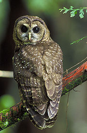
Northern Spotted Owl
The Northern Spotted Owl, Strix occidentalis caurina, is one of three Spotted Owl subspecies. A Western North American bird in the family Strigidae, genus Strix, it is a medium-sized dark brown owl sixteen to nineteen inches in length and one to one and one sixth pounds. Females are larger than males...
, a critically endangered
Critically endangered
Version 2010.3 of the IUCN Red List of Threatened Species identified 3744 Critically Endangered species, subspecies and varieties, stocks and subpopulations.Critically Endangered by kingdom:*1993 Animalia*2 Fungi*1745 Plantae*4 Protista-References:...
species. Two other species known to live in the watershed are included in the IUCN Red List
IUCN Red List
The IUCN Red List of Threatened Species , founded in 1963, is the world's most comprehensive inventory of the global conservation status of biological species. The International Union for Conservation of Nature is the world's main authority on the conservation status of species...
: the endangered
Endangered species
An endangered species is a population of organisms which is at risk of becoming extinct because it is either few in numbers, or threatened by changing environmental or predation parameters...
Siskiyou Mountains Salamander
Siskiyou Mountains salamander
The Siskiyou Mountains salamander, Plethodon stormi, also called the Siskiyou Mountain salamander, exists only in isolated locations along the Klamath River in northern California and southern Oregon...
, and the vulnerable Western Pond Turtle
Western pond turtle
The western pond turtle , or Pacific pond turtle is a small to medium-sized turtle growing to approximately 20 cm in carapace length. It is limited to the west coast of the United States of America and Mexico, ranging from western Washington state to northern Baja California...
. Bighorn Sheep
Bighorn Sheep
The bighorn sheep is a species of sheep in North America named for its large horns. These horns can weigh up to , while the sheep themselves weigh up to . Recent genetic testing indicates that there are three distinct subspecies of Ovis canadensis, one of which is endangered: Ovis canadensis sierrae...
, Gray Wolves
Gray Wolf
The gray wolf , also known as the wolf, is the largest extant wild member of the Canidae family...
, Grizzly Bear
Grizzly Bear
The grizzly bear , also known as the silvertip bear, the grizzly, or the North American brown bear, is a subspecies of brown bear that generally lives in the uplands of western North America...
s, and Pronghorn
Pronghorn
The pronghorn is a species of artiodactyl mammal endemic to interior western and central North America. Though not an antelope, it is often known colloquially in North America as the prong buck, pronghorn antelope, or simply antelope, as it closely resembles the true antelopes of the Old World and...
s once inhabited the region, but are now considered extirpated
Local extinction
Local extinction, also known as extirpation, is the condition of a species which ceases to exist in the chosen geographic area of study, though it still exists elsewhere...
.
The most common fish inhabiting the river include Chinook Salmon
Chinook salmon
The Chinook salmon, Oncorhynchus tshawytscha, is the largest species in the pacific salmon family. Other commonly used names for the species include King salmon, Quinnat salmon, Spring salmon and Tyee salmon...
, threatened
Threatened species
Threatened species are any speciesg animals, plants, fungi, etc.) which are vulnerable to endangerment in the near future.The World Conservation Union is the foremost authority on threatened species, and treats threatened species not as a single category, but as a group of three categories,...
Coho Salmon
Coho salmon
The Coho salmon, Oncorhynchus kisutch, is a species of anadromous fish in the salmon family. Coho salmon are also known as silver salmon or "silvers". It is the state animal of Chiba, Japan.-Description:...
, and Rainbow Trout
Rainbow trout
The rainbow trout is a species of salmonid native to tributaries of the Pacific Ocean in Asia and North America. The steelhead is a sea run rainbow trout usually returning to freshwater to spawn after 2 to 3 years at sea. In other words, rainbow trout and steelhead trout are the same species....
. Fish populations are declining, however, due to low water quality and barriers such as dams and culvert
Culvert
A culvert is a device used to channel water. It may be used to allow water to pass underneath a road, railway, or embankment. Culverts can be made of many different materials; steel, polyvinyl chloride and concrete are the most common...
s.
History
Humans have lived in the Little Applegate River watershed for approximately 11,000 years, based on Clovis pointClovis point
Clovis points are the characteristically-fluted projectile points associated with the North American Clovis culture. They date to the Paleoindian period around 13,500 years ago. Clovis fluted points are named after the city of Clovis, New Mexico, where examples were first found in 1929.At the right...
s discovered in the area. The first inhabitants were most likely the Latgawa, Shasta
Shasta (tribe)
The Shasta are an indigenous people of Northern California and Southern Oregon in the United States. They spoke one of the Shastan languages....
, and Dakubetede tribes of Native Americans, descendants of the first humans who traveled across the Bering land bridge from Siberia
Siberia
Siberia is an extensive region constituting almost all of Northern Asia. Comprising the central and eastern portion of the Russian Federation, it was part of the Soviet Union from its beginning, as its predecessor states, the Tsardom of Russia and the Russian Empire, conquered it during the 16th...
. The Native Americans often set fires to clear brush from prairies and oak savanna regions, and also to promote the growth of certain crops. The fires were limited by the Native Americans, creating a patchwork of burned and unburned land, thus increasing the biodiversity
Biodiversity
Biodiversity is the degree of variation of life forms within a given ecosystem, biome, or an entire planet. Biodiversity is a measure of the health of ecosystems. Biodiversity is in part a function of climate. In terrestrial habitats, tropical regions are typically rich whereas polar regions...
of the watershed.
The first European Americans to visit the area were a group of fur trappers led by Peter Skene Ogden
Peter Skene Ogden
Peter Skene Ogden , was a fur trader and a Canadian explorer of what is now British Columbia and the American West...
in 1827. The community of Buncom was founded by Chinese
Overseas Chinese
Overseas Chinese are people of Chinese birth or descent who live outside the Greater China Area . People of partial Chinese ancestry living outside the Greater China Area may also consider themselves Overseas Chinese....
miners in 1851 when gold, silver, cinnabar
Cinnabar
Cinnabar or cinnabarite , is the common ore of mercury.-Word origin:The name comes from κινναβαρι , a Greek word most likely applied by Theophrastus to several distinct substances...
(mercury
Mercury (element)
Mercury is a chemical element with the symbol Hg and atomic number 80. It is also known as quicksilver or hydrargyrum...
), and chromite
Chromite
Chromite is an iron chromium oxide: FeCr2O4. It is an oxide mineral belonging to the spinel group. Magnesium can substitute for iron in variable amounts as it forms a solid solution with magnesiochromite ; substitution of aluminium occurs leading to hercynite .-Occurrence:Chromite is found in...
were discovered in nearby Jacksonville
Jacksonville, Oregon
Jacksonville is a city in Jackson County, Oregon, United States, a few miles west of Medford. It was named for Jackson Creek, which runs through the community and was the site of one of the first placer gold claims in the area. It includes Jacksonville Historic District which was designated a U.S....
.
In the spring of 1854, James Sterling and Aaron Davis discovered gold in the Sterling Creek area, and hundreds of miners soon arrived. The town of Sterlingville was founded, and by October its population had risen to over 1,500. Mining lasted through the 1850s and 60s, and much of the riverbeds
Stream bed
A stream bed is the channel bottom of a stream, river or creek; the physical confine of the normal water flow. The lateral confines or channel margins, during all but flood stage, are known as the stream banks or river banks. In fact, a flood occurs when a stream overflows its banks and flows onto...
of Sterling Creek and the lower Little Applegate River were excavated. The Sterling Ditch and several other ditches were constructed in the 1870s, providing water to large hydraulic mining operations in Sterlingville and surrounding regions. The Sterlingville mine quickly became the largest hydraulic mine in Oregon, and possibly the entire western United States
Western United States
.The Western United States, commonly referred to as the American West or simply "the West," traditionally refers to the region comprising the westernmost states of the United States. Because the U.S. expanded westward after its founding, the meaning of the West has evolved over time...
.
Hundreds of thousands of tons of earth and sediment were washed into the Little Applegate and its tributaries, and the mining devastated the landscape. The Sterlingville post office
Post office
A post office is a facility forming part of a postal system for the posting, receipt, sorting, handling, transmission or delivery of mail.Post offices offer mail-related services such as post office boxes, postage and packaging supplies...
opened in 1879, but was closed four years later as the town's population declined. Buncom's post office opened in 1896. By 1910, however, most mining operations had ended, and it was closed in 1918. Hydraulic mines were reopened from 1933 to 1957 during the Great Depression
Great Depression
The Great Depression was a severe worldwide economic depression in the decade preceding World War II. The timing of the Great Depression varied across nations, but in most countries it started in about 1929 and lasted until the late 1930s or early 1940s...
. Three building remain in Buncom, but Sterlingville was abandoned and destroyed.
Pollution
The water quality of the Little Applegate River watershed is generally poor due to high temperatures, sedimentationSedimentation
Sedimentation is the tendency for particles in suspension to settle out of the fluid in which they are entrained, and come to rest against a barrier. This is due to their motion through the fluid in response to the forces acting on them: these forces can be due to gravity, centrifugal acceleration...
, and oxygen saturation
Oxygen saturation
Oxygen saturation or dissolved oxygen is a relative measure of the amount of oxygen that is dissolved or carried in a given medium. It can be measured with a dissolved oxygen probe such as an oxygen sensor or an optode in liquid media, usually water.It has particular significance in medicine and...
levels which occur throughout the region. Most of these problems are created by human activity; forests and riparian zone
Riparian zone
A riparian zone or riparian area is the interface between land and a river or stream. Riparian is also the proper nomenclature for one of the fifteen terrestrial biomes of the earth. Plant habitats and communities along the river margins and banks are called riparian vegetation, characterized by...
s have been cleared to make way for agriculture, and high road densities cause slope failures
Landslide
A landslide or landslip is a geological phenomenon which includes a wide range of ground movement, such as rockfalls, deep failure of slopes and shallow debris flows, which can occur in offshore, coastal and onshore environments...
. Hydraulic mining near Sterlingville devastated the surrounding landscape, leaving the slopes bare and sending rocks and gravel downstream. Cattle
Cattle
Cattle are the most common type of large domesticated ungulates. They are a prominent modern member of the subfamily Bovinae, are the most widespread species of the genus Bos, and are most commonly classified collectively as Bos primigenius...
and sheep were introduced to the area in the late 19th century; they have since overgrazed
Overgrazing
Overgrazing occurs when plants are exposed to intensive grazing for extended periods of time, or without sufficient recovery periods. It can be caused by either livestock in poorly managed agricultural applications, or by overpopulations of native or non-native wild animals.Overgrazing reduces the...
some areas of the watershed, reducing native grasses and allowing noxious weeds to spread. Overgrazing also contributes to soil erosion. Large amounts of water is diverted from the river and its tributaries, sometimes so much that the mouth is left nearly dry.
A major contributor to the sedimentation of the Little Applegate River is McDonald Ditch, an irrigation ditch
Ditch
A ditch is usually defined as a small to moderate depression created to channel water.In Anglo-Saxon, the word dïc already existed and was pronounced 'deek' in northern England and 'deetch' in the south. The origins of the word lie in digging a trench and forming the upcast soil into a bank...
near McDonald Creek. Built in 1920 to provide water to residents of nearby Wagner Creek, the ditch has failed numerous times, sending several tons of dirt and mud downstream.
The Talent
Talent, Oregon
Talent is a city in Jackson County, Oregon, United States. The population was 5,589 at the 2000 census and 6,680 as of July 1, 2009.-Geography:According to the United States Census Bureau, the city has a total area of , all of it land....
Irrigation District approved purchasing a $10,000 monitoring system for the ditch in September 2010, and applied for a $100,000 United States Bureau of Reclamation
United States Bureau of Reclamation
The United States Bureau of Reclamation , and formerly the United States Reclamation Service , is an agency under the U.S...
grant to replace the ditch with pipes.