
List of bridges in Montreal
Encyclopedia
Like most major cities, Montreal
needs easy highway access from its suburbs and surrounding areas. However, because Montreal was built on an island surrounded by three rivers
, it can be entered by land only on a bridge. Although the city was founded in 1642, it was not before 1847 that the first fixed link to the outside was established when a wooden bridge was built across Rivière des Prairies
to Île Jésus
, on the site of what is now Ahuntsic Bridge. Another bridge was built immediately afterward, a few kilometers west, which became Lachapelle Bridge
, and another in 1849, Pont des Saints-Anges, to the east. The latter bridge collapsed in the 1880s and was never rebuilt.
With the advent of the railroad, Montreal got a fixed link to the mainland; in 1854 railroad bridges were built in Sainte-Anne-de-Bellevue, across both channels of the Ottawa River
, linking Montreal Island to Ontario
and the Vaudreuil-Soulanges peninsula through Perrot Island. In 1860, Montreal got its first link to the South Shore
with the construction of Victoria Bridge
, which was, at the time of its opening, the longest bridge in the world. Indirect links to the North Shore also had to wait for railroad construction, but this took longer; the Canadian Pacific Railway
opened its link to Saint-Jérôme
in 1876, through Île Jésus.
proceeds counter-clockwise around the island from southwest, at the exit of Lake Saint-Louis
, downstream along the St. Lawrence River, then upstream along Rivière des Prairies
all the way to Lake of Two Mountains, then downstream again along the East Channel of the Ottawa River
until it reaches Lake Saint-Louis. The year of construction is that of the structure currently in place, accompanied by the year of construction of the original structure if the current one replaced an older span.
has always proved problematic for engineers. The construction of Victoria Bridge for the Grand Trunk Railway
, which, at 2 kilometres (1.2 mi), was the longest bridge in the world when it first opened in 1860, highlighted the problems presented by this natural obstacle. Not to be outdone by its rival, however, the Canadian Pacific Railway
built its own span, the Saint-Laurent Railway Bridge
, over the Lachine Rapids
, in 1886. Although Victoria Bridge was also used as a road crossing since 1898, it was not before the 1930s that two fully dedicated road bridges, Jacques-Cartier and Mercier
, were built. More spans, including Louis Hippolyte Lafontaine Tunnel and Champlain Bridge, were built in the 1960s. No new structure was built ever since, and none of the existing ones have been upgraded or widened.
The construction of the Saint Lawrence Seaway
in the 1950s required extensive modifications for all spans that existed at the time. Those are not reflected in the table below.
is much smaller than the Saint Lawrence, bridge construction there did not begin until the 1840s—when rapid construction began on three wooden toll bridges to what is now Laval
, one of which, Pont des Saints-Anges, collapsed in the 1880s and was never rebuilt. The existence of regular ferry services across the river is attested from 1813, but these ferries were discontinued when the bridges opened. The first railroad across the river was opened in 1876, and the Bordeaux Railway Bridge
is the oldest fixed link to Laval that is still standing. (Another bridge across Rivière des Mille Îles
, which was part of the same line, collapsed in 1882 but was immediately rebuilt.) The highway construction boom of the 1960s and 1970s led to the construction of four new freeway bridges across the river, and the upgrading of the existing Pie IX Bridge
to freeway standards.
bridge across the Ottawa River
East Channel. Along with another bridge built simultaneously across the West Channel, this bridge provided the first fixed link from Montreal to the mainland. It was not until 1925, however, that a fixed road link, formed by Galipeault Bridge
and Taschereau Bridge
, was built across the Ottawa River from Montreal Island. Perrot Island was the only way out of Montreal to the West before the construction of Île aux Tourtes Bridge
, which goes directly to Vaudreuil across the Lake of Two Mountains.
All three spans across the Ottawa River East Channel are twinned by another span, built simultaneously, across the West Channel.
Montreal
Montreal is a city in Canada. It is the largest city in the province of Quebec, the second-largest city in Canada and the seventh largest in North America...
needs easy highway access from its suburbs and surrounding areas. However, because Montreal was built on an island surrounded by three rivers
Island of Montreal
The Island of Montreal , in extreme southwestern Quebec, Canada, is located at the confluence of the Saint Lawrence and Ottawa Rivers. It is separated from Île Jésus by the Rivière des Prairies....
, it can be entered by land only on a bridge. Although the city was founded in 1642, it was not before 1847 that the first fixed link to the outside was established when a wooden bridge was built across Rivière des Prairies
Rivière des Prairies
The Rivière des Prairies is a delta channel of the Ottawa River in southwestern Quebec, Canada....
to Île Jésus
Île Jésus
Île Jésus is an island in southwestern Quebec, separated from the mainland to the north by the Rivière des Mille Îles, and from the Island of Montreal to the south by the Rivière des Prairies....
, on the site of what is now Ahuntsic Bridge. Another bridge was built immediately afterward, a few kilometers west, which became Lachapelle Bridge
Lachapelle Bridge
'Lachapelle Bridge', in French Pont Lachapelle, Also known as Cartierville Bridge.This bridge spans the Rivière des Prairies between the Montreal borough of Ahuntsic-Cartierville and the Laval neighbourhood of Chomedey.Actually there are two bridges, side by side and parallel:The older three...
, and another in 1849, Pont des Saints-Anges, to the east. The latter bridge collapsed in the 1880s and was never rebuilt.
With the advent of the railroad, Montreal got a fixed link to the mainland; in 1854 railroad bridges were built in Sainte-Anne-de-Bellevue, across both channels of the Ottawa River
Ottawa River
The Ottawa River is a river in the Canadian provinces of Ontario and Quebec. For most of its length, it now defines the border between these two provinces.-Geography:...
, linking Montreal Island to Ontario
Ontario
Ontario is a province of Canada, located in east-central Canada. It is Canada's most populous province and second largest in total area. It is home to the nation's most populous city, Toronto, and the nation's capital, Ottawa....
and the Vaudreuil-Soulanges peninsula through Perrot Island. In 1860, Montreal got its first link to the South Shore
South Shore (Montreal)
The South Shore is the general term for the suburbs of Montreal, Quebec located on the southern shore of the Saint Lawrence River opposite the Island of Montreal. The South Shore is located within the Quebec administrative region of Montérégie....
with the construction of Victoria Bridge
Victoria Bridge (Montreal)
Victoria Bridge , formerly originally known as Victoria Jubilee Bridge, is a bridge over the St. Lawrence River, linking Montreal, Quebec, to the south shore city of Saint-Lambert....
, which was, at the time of its opening, the longest bridge in the world. Indirect links to the North Shore also had to wait for railroad construction, but this took longer; the Canadian Pacific Railway
Canadian Pacific Railway
The Canadian Pacific Railway , formerly also known as CP Rail between 1968 and 1996, is a historic Canadian Class I railway founded in 1881 and now operated by Canadian Pacific Railway Limited, which began operations as legal owner in a corporate restructuring in 2001...
opened its link to Saint-Jérôme
Saint-Jérôme, Quebec
Saint-Jérôme is a town in Quebec, Canada, near Mirabel, about northwest of Montreal along Autoroute des Laurentides. The town is a gateway to the Laurentian Mountains and its resorts....
in 1876, through Île Jésus.
Crossings
This list of bridges and other fixed links serving the Island of MontrealIsland of Montreal
The Island of Montreal , in extreme southwestern Quebec, Canada, is located at the confluence of the Saint Lawrence and Ottawa Rivers. It is separated from Île Jésus by the Rivière des Prairies....
proceeds counter-clockwise around the island from southwest, at the exit of Lake Saint-Louis
Lake Saint-Louis
Lake Saint-Louis, or in French , is a lake in extreme southwestern Quebec, Canada, adjoining the Island of Montreal at the confluence of the Saint Lawrence and Ottawa Rivers.The lake is bounded to the north and east by the Island of Montreal...
, downstream along the St. Lawrence River, then upstream along Rivière des Prairies
Rivière des Prairies
The Rivière des Prairies is a delta channel of the Ottawa River in southwestern Quebec, Canada....
all the way to Lake of Two Mountains, then downstream again along the East Channel of the Ottawa River
Ottawa River
The Ottawa River is a river in the Canadian provinces of Ontario and Quebec. For most of its length, it now defines the border between these two provinces.-Geography:...
until it reaches Lake Saint-Louis. The year of construction is that of the structure currently in place, accompanied by the year of construction of the original structure if the current one replaced an older span.
| Key: Communities linked by individual bridges |
|---|
Spanning the Saint Lawrence River and Saint Lawrence Seaway
The crossing of the Saint Lawrence RiverSaint Lawrence River
The Saint Lawrence is a large river flowing approximately from southwest to northeast in the middle latitudes of North America, connecting the Great Lakes with the Atlantic Ocean. It is the primary drainage conveyor of the Great Lakes Basin...
has always proved problematic for engineers. The construction of Victoria Bridge for the Grand Trunk Railway
Grand Trunk Railway
The Grand Trunk Railway was a railway system which operated in the Canadian provinces of Quebec and Ontario, as well as the American states of Connecticut, Maine, Michigan, Massachusetts, New Hampshire, and Vermont. The railway was operated from headquarters in Montreal, Quebec; however, corporate...
, which, at 2 kilometres (1.2 mi), was the longest bridge in the world when it first opened in 1860, highlighted the problems presented by this natural obstacle. Not to be outdone by its rival, however, the Canadian Pacific Railway
Canadian Pacific Railway
The Canadian Pacific Railway , formerly also known as CP Rail between 1968 and 1996, is a historic Canadian Class I railway founded in 1881 and now operated by Canadian Pacific Railway Limited, which began operations as legal owner in a corporate restructuring in 2001...
built its own span, the Saint-Laurent Railway Bridge
Saint-Laurent Railway Bridge
The Saint-Laurent Railway Bridge is a Canadian Pacific railway bridge linking LaSalle to the Kahnawake Mohawk Reserve, just upstream of the Mercier Bridge. It is used by the AMT...
, over the Lachine Rapids
Lachine Rapids
The Lachine Rapids are a series of rapids on the Saint Lawrence River, between the Island of Montreal and the south shore. They are located near the former city of Lachine....
, in 1886. Although Victoria Bridge was also used as a road crossing since 1898, it was not before the 1930s that two fully dedicated road bridges, Jacques-Cartier and Mercier
Honoré Mercier Bridge
The Honoré Mercier Bridge in Quebec, Canada, connects the Montreal borough of LaSalle on the Island of Montreal with the Mohawk reserve of Kahnawake and the suburb of Châteauguay on the south shore of the Saint Lawrence River. It is the most direct southerly route from the island of Montreal toward...
, were built. More spans, including Louis Hippolyte Lafontaine Tunnel and Champlain Bridge, were built in the 1960s. No new structure was built ever since, and none of the existing ones have been upgraded or widened.
The construction of the Saint Lawrence Seaway
Saint Lawrence Seaway
The Saint Lawrence Seaway , , is the common name for a system of locks, canals and channels that permits ocean-going vessels to travel from the Atlantic Ocean to the North American Great Lakes, as far as Lake Superior. Legally it extends from Montreal to Lake Erie, including the Welland Canal...
in the 1950s required extensive modifications for all spans that existed at the time. Those are not reflected in the table below.
| Span | Picture | First span built | Current span built | Communities linked | Carries | Name origin | Coordinates Geographic coordinate system A geographic coordinate system is a coordinate system that enables every location on the Earth to be specified by a set of numbers. The coordinates are often chosen such that one of the numbers represent vertical position, and two or three of the numbers represent horizontal position... |
|---|---|---|---|---|---|---|---|
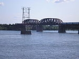
| Saint-Laurent Railway Bridge Saint-Laurent Railway Bridge The Saint-Laurent Railway Bridge is a Canadian Pacific railway bridge linking LaSalle to the Kahnawake Mohawk Reserve, just upstream of the Mercier Bridge. It is used by the AMT... |
 |
1886 | (M) Borough of LaSalle | Canadian Pacific Railway Canadian Pacific Railway The Canadian Pacific Railway , formerly also known as CP Rail between 1968 and 1996, is a historic Canadian Class I railway founded in 1881 and now operated by Canadian Pacific Railway Limited, which began operations as legal owner in a corporate restructuring in 2001... (CPR) Agence métropolitaine de transport Agence métropolitaine de transport The Agence métropolitaine de transport is the umbrella organization that plans, integrates, and coordinates public transportation services across Canada's Greater Montreal Region, including the Island of Montreal, Laval , and communities along both the North Shore of the Rivière des Mille-Îles... (AMT) Delson-Candiac (commuter train Commuter rail in North America Commuter rail services in the United States, Canada, and Mexico provide common carrier passenger transportation along railway tracks, with scheduled service on fixed routes on a non-reservation basis primarily for short-distance travel between a central business district and adjacent suburbs and... ) |
Saint Lawrence River Saint Lawrence River The Saint Lawrence is a large river flowing approximately from southwest to northeast in the middle latitudes of North America, connecting the Great Lakes with the Atlantic Ocean. It is the primary drainage conveyor of the Great Lakes Basin... |
45°25′8"N 73°39′34"W | |
| (O) Kahnawake Mohawk Mohawk nation Mohawk are the most easterly tribe of the Iroquois confederation. They call themselves Kanien'gehaga, people of the place of the flint... Reserve Indian reserve In Canada, an Indian reserve is specified by the Indian Act as a "tract of land, the legal title to which is vested in Her Majesty, that has been set apart by Her Majesty for the use and benefit of a band." The Act also specifies that land reserved for the use and benefit of a band which is not... |
|||||||
| Honoré Mercier Bridge Honoré Mercier Bridge The Honoré Mercier Bridge in Quebec, Canada, connects the Montreal borough of LaSalle on the Island of Montreal with the Mohawk reserve of Kahnawake and the suburb of Châteauguay on the south shore of the Saint Lawrence River. It is the most direct southerly route from the island of Montreal toward... |
 |
1934, 1963 | (M) Borough of LaSalle |  Quebec route 138 Route 138 is a major highway in the Canadian province of Quebec, following the entire north shore of the Saint Lawrence River past Montreal to the eastern terminus in Natashquan on the Gulf of Saint Lawrence. The western terminus is in Elgin, at the border with New York State south-west of Montreal... |
Honoré Mercier Honoré Mercier Honoré Mercier was a lawyer, journalist and politician in Quebec, Canada. He was the ninth Premier of Quebec from January 27, 1887 to December 21, 1891, as leader of the Parti National or Quebec Liberal Party .... (1840–1894), Premier of Quebec |
45°25′0"N 73°39′18"W | |
| (O) Kahnawake Mohawk Reserve | |||||||
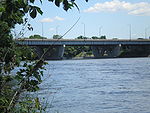
| Champlain Bridge Ice Structure | 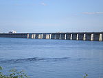 |
1964 | (M) Borough of Verdun | Route Verte Route Verte The Route Verte is a network of bicycling and multiuse trails and designated roads, lanes, and surfaces, spanning 4036 kilometres as of October 31, 2008, in the Canadian province of Quebec, inaugurated on August 10, 2007... 1 and 2 |
Samuel de Champlain Samuel de Champlain Samuel de Champlain , "The Father of New France", was a French navigator, cartographer, draughtsman, soldier, explorer, geographer, ethnologist, diplomat, and chronicler. He founded New France and Quebec City on July 3, 1608.... (c. 1580–1635), founder of Quebec City Quebec City Quebec , also Québec, Quebec City or Québec City is the capital of the Canadian province of Quebec and is located within the Capitale-Nationale region. It is the second most populous city in Quebec after Montreal, which is about to the southwest... |
45°27′57"N 73°31′11"W | |
| (O) St. Lawrence Seaway levee Levee A levee, levée, dike , embankment, floodbank or stopbank is an elongated naturally occurring ridge or artificially constructed fill or wall, which regulates water levels... |
|||||||
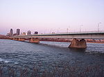
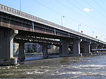
| Champlain Bridge | 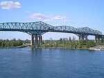 |
1962 | (M) Borough of Verdun |    Autoroutes 10 Quebec Autoroute 10 Autoroute 10 is an Autoroute in southern Quebec, Canada... , 15 Quebec Autoroute 15 Autoroute 15 is a highway in western Quebec, Canada... , and 20 Quebec Autoroute 20 Autoroute 20 is a major Quebec Autoroute, following the Saint Lawrence River through one of the more densely-populated parts of Canada, and is part of the Trans-Canada Highway. At , it is the longest Autoroute in Quebec... |
45°28′7"N 73°31′15"W | ||
| (I) Île des Sœurs (exit) | |||||||
| (O) Brossard Brossard Brossard is a suburban area, located on the south shore of the Saint Lawrence River, opposite the island and city of Montreal.Brossard is subdivided into many smaller sections. These sections are characterized by having street names that all begin with the same letter of the alphabet... |
|||||||
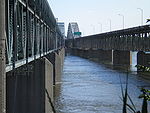
| Victoria Bridge | 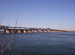 |
1860 | 1898 | (M) Borough of Le Sud-Ouest Le Sud-Ouest Le Sud-Ouest is a borough of the city of Montreal, Quebec, Canada.-Geography:Le Sud-Ouest is an amalgam of several neighbourhoods with highly distinct histories and identities, mainly with working-class and industrial origins, grouped around the Lachine Canal... |
Route 112 Quebec route 112 Route 112 is a busy east/west highway on the south shore of the Saint Lawrence River in Quebec, Canada. Its eastern terminus is in Frampton at the junction of Route 275, and the western terminus is in Downtown Montreal , after crossing the Victoria Bridge... Canadian National Railway Canadian National Railway The Canadian National Railway Company is a Canadian Class I railway headquartered in Montreal, Quebec. CN's slogan is "North America's Railroad".... (CN) AMT Agence métropolitaine de transport The Agence métropolitaine de transport is the umbrella organization that plans, integrates, and coordinates public transportation services across Canada's Greater Montreal Region, including the Island of Montreal, Laval , and communities along both the North Shore of the Rivière des Mille-Îles... Mont-Saint-Hilaire commuter train Commuter rail in North America Commuter rail services in the United States, Canada, and Mexico provide common carrier passenger transportation along railway tracks, with scheduled service on fixed routes on a non-reservation basis primarily for short-distance travel between a central business district and adjacent suburbs and... Via Rail VIA Rail Via Rail Canada is an independent crown corporation offering intercity passenger rail services in Canada. It is headquartered near Montreal Central Station at 3 Place Ville-Marie in Montreal, Quebec.... and Amtrak Adirondack (Amtrak) The Adirondack is a passenger train operated daily by Amtrak between New York City and Montreal. The trip takes approximately 11 hours to cover a published distance of , traveling through the scenic Hudson Valley and the Adirondack Mountains... passenger trains |
Queen Victoria of the United Kingdom Victoria of the United Kingdom Victoria was the monarch of the United Kingdom of Great Britain and Ireland from 20 June 1837 until her death. From 1 May 1876, she used the additional title of Empress of India.... (1819–1901) |
45°29′29"N 73°31′46"W |
| (O) Saint-Lambert Saint-Lambert, Quebec Saint-Lambert is a Canadian city in the province of Quebec located opposite Montreal on the south shore of the St. Lawrence River. Saint-Lambert was named for either the early French Canadian hunter Lambert Closse or for Roman Catholic Bishop Lambert of Maastricht... |
|||||||
| Pont de la Concorde Concorde Bridge The Concordia Bridge carries Avenue Pierre-Dupuy across the St. Lawrence River between Cité du Havre , Montreal, and Parc Jean-Drapeau on Saint Helen's Island. A majority of its traffic is motorists driving to the Montreal Casino on Île Notre-Dame, continuing on Pierre Dupuy Avenue across Pont des... and Pont des Îles |
 |
1965 | (M) Borough of Ville-Marie | Pierre-Dupuy Avenue and Route Verte Route Verte The Route Verte is a network of bicycling and multiuse trails and designated roads, lanes, and surfaces, spanning 4036 kilometres as of October 31, 2008, in the Canadian province of Quebec, inaugurated on August 10, 2007... 1 and 2 |
Reference to Montreal's motto, Concordia salus | 45°30′22"N 73°32′17"W (Pont de la Concorde) 45°30′28"N 73°31′49"W (Pont des Îles) |
|
| (O) Île Sainte-Hélène and Île Notre-Dame Île Notre-Dame Île Notre-Dame is an artificial island built in 10 months from 15 million tons of rock excavated for the Montreal Metro in 1965. It was created for Expo 67 to celebrate Canada's centennial. The island is part of the city of Montreal and forms part of the Hochelaga Archipelago... (Parc Jean-Drapeau Parc Jean-Drapeau Parc Jean-Drapeau is situated to the east of downtown Montreal, Quebec, Canada, in the Saint Lawrence River. It comprises two islands, Saint Helen's Island and the artificial island Île Notre-Dame.... ), borough of Ville-Marie, Montreal |
|||||||
| Montreal Metro Tunnel | 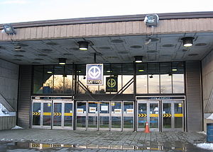 |
1966 | (M) Borough of Ville-Marie (Berri-UQAM Berri-UQAM (Montreal Metro) Berri-UQAM is the central station of the Montreal Metro rapid transit system operated by the Société de transport de Montréal . It is located in the Quartier Latin, in the borough of Ville-Marie, in Montreal, Quebec, Canada. The station opened on October 14, 1966, as part of the original network... station) |
Line 4 Yellow Line 4 Yellow (Montreal Metro) The Yellow line is one of the metro's four routes operating in Montreal, Quebec, Canada. It was popular when it opened for service because it connected Montreal's city centre with the Expo 67 exhibition and La Ronde on Île-Sainte-Hélène. Line 4 has three stations, and travels under the St.... |
45°30′N 73°32′W | ||
| (I) Île Sainte-Hélène (Jean-Drapeau Jean-Drapeau (Montreal Metro) Jean-Drapeau is a station on the Yellow Line of the Montreal Metro rapid transit system, operated by the Société de transport de Montréal... station) and Île Notre-Dame |
|||||||
| (O) Longueuil Longueuil Longueuil is a city in the province of Quebec, Canada. It is the seat of the Montérégie administrative region and sits on the south shore of the Saint Lawrence River directly across from Montreal. The population as of the Canada 2006 Census totaled 229,330, making it the third largest city in... , borough of Vieux-Longueuil (Longueuil–Université-de-Sherbrooke Longueuil–Université-de-Sherbrooke (Montreal Metro) Longueuil–Université-de-Sherbrooke is a station at the southern terminus of the Yellow Line of the Montreal Metro rapid transit system, operated by the Société de transport de Montréal . It is located in the city of Longueuil, Quebec, Canada.... station) |
|||||||
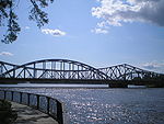
| Jacques Cartier Bridge Jacques Cartier Bridge The Jacques Cartier Bridge is a steel truss cantilever bridge crossing the Saint Lawrence River from Montreal Island, Montreal, Quebec to the south shore at Longueuil, Quebec, Canada... |
1930 | (M) Borough of Ville-Marie | Route 134 Quebec route 134 Route 134 is a highway in the province of Quebec, running from Candiac on the South Shore of the Saint Lawrence River to Montreal, crossing the river on Jacques Cartier Bridge. On the South Shore, Route 134 is named Taschereau Boulevard , after the prominent Quebec family that included former... Pedestrians and bicycles |
Jacques Cartier Jacques Cartier Jacques Cartier was a French explorer of Breton origin who claimed what is now Canada for France. He was the first European to describe and map the Gulf of Saint Lawrence and the shores of the Saint Lawrence River, which he named "The Country of Canadas", after the Iroquois names for the two big... (1491–1557), French explorer |
45°31′17"N 73°32′28"W | ||
| (I) Île Sainte-Hélène (exit) and Île Notre-Dame | |||||||
| (O) Longueuil, borough of Vieux-Longueuil | |||||||
| Louis Hippolyte Lafontaine Tunnel |  |
1967 | (M) Borough of Mercier–Hochelaga-Maisonneuve Mercier–Hochelaga-Maisonneuve Mercier–Hochelaga-Maisonneuve is a borough of Montreal, Quebec.-History:In 1860, Hochelaga developed as a village counting a little more than 1000 inhabitants. In 1874, Hudon — a cotton factory- moved in... |
 Quebec Autoroute 25 Autoroute 25 is an Autoroute in the Lanaudière region of Quebec. It is currently long.... |
Louis-Hippolyte Lafontaine Louis-Hippolyte Lafontaine Sir Louis-Hippolyte Lafontaine , 1st Baronet, KCMG was the first Canadian to become Prime Minister of the United Province of Canada and the first head of a responsible government in Canada. He was born in Boucherville, Lower Canada in 1807... (1807–1864), Prime Minister Joint Premiers of the Province of Canada Joint Premiers of the Province of Canada were the leaders of the Province of Canada, from the 1841 unification of Upper Canada and Lower Canada until Confederation in 1867.... of the United Province of Canada |
45°35′0"N 73°29′51"W | |
| (I) Île Charron (Îles de Boucherville) (exit) | |||||||
| (O) Longueuil, borough of Vieux-Longueuil | |||||||
Spanning the Rivière des Prairies
Although the Rivière des PrairiesRivière des Prairies
The Rivière des Prairies is a delta channel of the Ottawa River in southwestern Quebec, Canada....
is much smaller than the Saint Lawrence, bridge construction there did not begin until the 1840s—when rapid construction began on three wooden toll bridges to what is now Laval
Laval, Quebec
Laval is a Canadian city and a region in southwestern Quebec. It is the largest suburb of Montreal, the third largest municipality in the province of Quebec, and the 14th largest city in Canada with a population of 368,709 in 2006...
, one of which, Pont des Saints-Anges, collapsed in the 1880s and was never rebuilt. The existence of regular ferry services across the river is attested from 1813, but these ferries were discontinued when the bridges opened. The first railroad across the river was opened in 1876, and the Bordeaux Railway Bridge
Bordeaux Railway Bridge
The Bordeaux Railway Bridge is a railway bridge on the Canadian Pacific Railway line across the Rivière des Prairies between Ahuntsic-Cartierville, on Montreal Island, and Laval-des-Rapides, Laval, Quebec, Canada...
is the oldest fixed link to Laval that is still standing. (Another bridge across Rivière des Mille Îles
Rivière des Mille Îles
The Rivière des Mille Îles is a channel of the Ottawa River in southwestern Quebec, Canada and runs into the Rivière des Prairies....
, which was part of the same line, collapsed in 1882 but was immediately rebuilt.) The highway construction boom of the 1960s and 1970s led to the construction of four new freeway bridges across the river, and the upgrading of the existing Pie IX Bridge
Pie IX Bridge
The Pie IX Bridge is a bridge in Quebec, spanning the Rivière des Prairies. It connects the Saint-Vincent-de-Paul area of Laval, on Île Jésus, and the borough of Montreal North in Montreal, on the Island of Montreal...
to freeway standards.
| Span | Picture | First span built | Current span built | Communities linked | Carries | Name origin | Coordinates Geographic coordinate system A geographic coordinate system is a coordinate system that enables every location on the Earth to be specified by a set of numbers. The coordinates are often chosen such that one of the numbers represent vertical position, and two or three of the numbers represent horizontal position... |
|---|---|---|---|---|---|---|---|
| Pierre Le Gardeur Bridge Pierre Le Gardeur Bridge The Le Gardeur Bridge is a beam bridge that connects the east end of the island of Montreal to Charlemagne, Quebec.... |
.jpg) |
1939 (widened 1975) | (M) Borough of Rivière-des-Prairies–Pointe-aux-Trembles Rivière-des-Prairies–Pointe-aux-Trembles Rivière-des-Prairies–Pointe-aux-Trembles is a suburban borough on the eastern tip of the city of Montreal, Quebec, Canada. It is the farthest borough in the eastern end of the island of Montreal.-Geography:... |
Quebec route 138 Route 138 is a major highway in the Canadian province of Quebec, following the entire north shore of the Saint Lawrence River past Montreal to the eastern terminus in Natashquan on the Gulf of Saint Lawrence. The western terminus is in Elgin, at the border with New York State south-west of Montreal... and Route Verte Route Verte The Route Verte is a network of bicycling and multiuse trails and designated roads, lanes, and surfaces, spanning 4036 kilometres as of October 31, 2008, in the Canadian province of Quebec, inaugurated on August 10, 2007... 5 |
Pierre Le Gardeur de Repentigny (1605–1648), French lord | 45°42′13"N 73°29′1"W | |
| (I) Île Bourdon | |||||||
| (O) Repentigny Repentigny, Quebec Repentigny is an off-island suburb of Montreal, in the province of Quebec, located north of Montreal, on the lower end of the L'Assomption River and on the Saint Lawrence River. Repentigny and Charlemagne are the first towns off the island of Montreal.-History:... |
|||||||
| Laurier Railway Bridge | .jpg) |
1904 | (M) Borough of Rivière-des-Prairies–Pointe-aux-Trembles Rivière-des-Prairies–Pointe-aux-Trembles Rivière-des-Prairies–Pointe-aux-Trembles is a suburban borough on the eastern tip of the city of Montreal, Quebec, Canada. It is the farthest borough in the eastern end of the island of Montreal.-Geography:... |
CN Canadian National Railway The Canadian National Railway Company is a Canadian Class I railway headquartered in Montreal, Quebec. CN's slogan is "North America's Railroad".... Via Rail VIA Rail Via Rail Canada is an independent crown corporation offering intercity passenger rail services in Canada. It is headquartered near Montreal Central Station at 3 Place Ville-Marie in Montreal, Quebec.... |
Wilfrid Laurier Wilfrid Laurier Sir Wilfrid Laurier, GCMG, PC, KC, baptized Henri-Charles-Wilfrid Laurier was the seventh Prime Minister of Canada from 11 July 1896 to 6 October 1911.... (1841–1919), Prime Minister of Canada Prime Minister of Canada The Prime Minister of Canada is the primary minister of the Crown, chairman of the Cabinet, and thus head of government for Canada, charged with advising the Canadian monarch or viceroy on the exercise of the executive powers vested in them by the constitution... |
45°42′10"N 73°29′8"W | |
| (I) Île Bourdon | |||||||
| (O) Charlemagne Charlemagne, Quebec Charlemagne is an off-island suburb of Montreal, Quebec, Canada. It is located on the north shore of the Rivière des Prairies, northeast of Montreal's downtown core. As of 2006, the population was 5,594.... |
|||||||
| Charles de Gaulle Bridge Charles de Gaulle Bridge The Charles de Gaulle Bridge is a bridge that links the eastern tip of the island of Montreal, Quebec over the Rivière des Prairies to the Lanaudière region near the city of Charlemagne... |
.jpg) |
1965 | (M) Borough of Rivière-des-Prairies–Pointe-aux-Trembles Rivière-des-Prairies–Pointe-aux-Trembles Rivière-des-Prairies–Pointe-aux-Trembles is a suburban borough on the eastern tip of the city of Montreal, Quebec, Canada. It is the farthest borough in the eastern end of the island of Montreal.-Geography:... |
 Quebec Autoroute 40 Autoroute 40 is a major highway on the north shore of the St. Lawrence River in Quebec, Canada. It is one of the two main connections between Montreal and Quebec City... |
Charles de Gaulle Charles de Gaulle Charles André Joseph Marie de Gaulle was a French general and statesman who led the Free French Forces during World War II. He later founded the French Fifth Republic in 1958 and served as its first President from 1959 to 1969.... (1890–1970), President of France France The French Republic , The French Republic , The French Republic , (commonly known as France , is a unitary semi-presidential republic in Western Europe with several overseas territories and islands located on other continents and in the Indian, Pacific, and Atlantic oceans. Metropolitan France... |
45°42′7"N 73°30′32"W | |
| (O) Charlemagne | |||||||
| A25 Bridge | 2011 | (M) Borough of Rivière-des-Prairies–Pointe-aux-Trembles Rivière-des-Prairies–Pointe-aux-Trembles Rivière-des-Prairies–Pointe-aux-Trembles is a suburban borough on the eastern tip of the city of Montreal, Quebec, Canada. It is the farthest borough in the eastern end of the island of Montreal.-Geography:... |
Quebec Autoroute 25 Autoroute 25 is an Autoroute in the Lanaudière region of Quebec. It is currently long.... |
A25, the name of the private consortium that built the bridge and operates the toll system. | 45°38′16"N 73°37′14"W | ||
| (O) Laval Laval, Quebec Laval is a Canadian city and a region in southwestern Quebec. It is the largest suburb of Montreal, the third largest municipality in the province of Quebec, and the 14th largest city in Canada with a population of 368,709 in 2006... (Saint-François Saint-François, Quebec Saint-François is the second largest neighbourhood of Laval, Quebec, Canada, after Duvernay. It was a separate city until the municipal mergers on August 6, 1965.Agriculture occupies most of the land area.... ) |
|||||||
| Pie IX Bridge Pie IX Bridge The Pie IX Bridge is a bridge in Quebec, spanning the Rivière des Prairies. It connects the Saint-Vincent-de-Paul area of Laval, on Île Jésus, and the borough of Montreal North in Montreal, on the Island of Montreal... |
 |
1937 | 1967 | (M) Borough of Montreal North | Route 125 Quebec route 125 Route 125 is a Quebec highway running from Montreal to Saint-Donat, Quebec in the Laurentians. The southern section of Route 125 runs parallel to Autoroute 25 in Laval, Mascouche, and Terrebonne... |
Pope Pius IX Pope Pius IX Blessed Pope Pius IX , born Giovanni Maria Mastai-Ferretti, was the longest-reigning elected Pope in the history of the Catholic Church, serving from 16 June 1846 until his death, a period of nearly 32 years. During his pontificate, he convened the First Vatican Council in 1869, which decreed papal... (1792–1878) |
45°35′57"N 73°38′49"W |
| (O) Laval (Saint-Vincent-de-Paul Saint-Vincent-de-Paul, Quebec Saint-Vincent-de-Paul is a neighbourhood in the eastern part of Laval, Quebec, Canada. Saint-Vincent-de-Paul was a town before August 6, 1965. Saint-Vincent-de-Paul is named after Vincent de Paul.- Geography :... ) |
|||||||
| Centrale de la Rivière des Prairies Centrale de la Rivière des Prairies The Rivière des Prairies generating station is a run of river hydroelectric power station on the Rivière des Prairies between the islands of Jesus and Montreal, Quebec, Canada. Built in 1929, it is now managed and operated by Hydro-Québec... |
1930 | (M) Borough of Ahuntsic-Cartierville Ahuntsic-Cartierville Ahuntsic-Cartierville is a borough of the city of Montreal, Quebec, Canada.-Geography:The borough is located in the northern part of Montreal along the banks of the Rivière des Prairies, and includes some islands in the river such as Île aux Chats, Île Perry, and Île de la Visitation... |
Hydro-Québec Hydro-Québec Hydro-Québec is a government-owned public utility established in 1944 by the Government of Quebec. Based in Montreal, the company is in charge of the generation, transmission and distribution of electricity across Quebec.... |
Rivière des Prairies Rivière des Prairies The Rivière des Prairies is a delta channel of the Ottawa River in southwestern Quebec, Canada.... |
45°35′17"N 73°39′21"W | ||
| (I) Île de la Visitation Île de la Visitation Île de la Visitation is a small island in the Rivière des Prairies, part of the Hochelaga Archipelago, linked to the Island of Montreal in Quebec, Canada.... and Île du Cheval de Terre |
|||||||
| (O) Laval (Duvernay) | |||||||
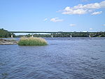
| Papineau-Leblanc Bridge Papineau-Leblanc Bridge The Papineau-Leblanc Bridge was one of the first cable-stayed spans, and was for many years the longest of this type, in the world. It is part of Quebec Autoroute 19 and is one of the connections between Laval and Montreal, Quebec, Canada, spanning Rivière des Prairies. It was fabricated from... |
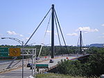 |
1969 | (M) Borough of Ahuntsic-Cartierville |  Quebec Autoroute 19 Autoroute 19, also known as Autoroute Papineau , is an autoroute in Quebec. It crosses the Rivière des Prairies via the Papineau-Leblanc Bridge, connecting the borough of Ahuntsic-Cartierville in Montreal and the Duvernay neighbourhood in Laval.There are plans to widen Route 335 to four lanes,... |
Louis-Joseph Papineau Louis-Joseph Papineau Louis-Joseph Papineau , born in Montreal, Quebec, was a politician, lawyer, and the landlord of the seigneurie de la Petite-Nation. He was the leader of the reformist Patriote movement before the Lower Canada Rebellion of 1837–1838. His father was Joseph Papineau, also a famous politician in Quebec... (1786–1871), leader of the Patriote movement Patriote movement The Patriote movement was a political movement that existed in Lower Canada from the turning of the 19th century to the Patriote Rebellion of 1837 and 1838 and the subsequent Act of Union of 1840. It was politically embodied by the Parti patriote at the Legislative Assembly of Lower Canada... Alpha Leblanc (1908–1962), local landowner |
45°34′34"N 73°40′1"W | |
| (I) Île de la Visitation | |||||||
| (O) Laval (Duvernay) | |||||||
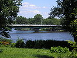
| Ahuntsic Bridge (Viau Bridge) | 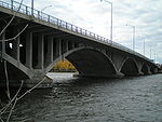 |
1847 | 1962 (widened 1993) | (M) Borough of Ahuntsic-Cartierville | Route 335 Quebec route 335 Route 335 is a north-south route from Montreal north into the Lanaudière region of Quebec.South of The Metropolitan 335 runs on Rue Saint-Denis to its southern terminus. Northwards until the Rivière des Prairies, 335 runs on Rue Berri south and Rue Lajeunesse north, then it runs over the Pont Viau... |
Ahuntsic, Huron boy who drowned in 1625 The origin of the name Viau is uncertain. | 45°33′26"N 73°40′32"W |
| (O) Laval (Pont-Viau Pont-Viau, Quebec Pont-Viau, Quebec is a neighbourhood in the southern part of Laval, Quebec, Canada. It was a town before August 6, 1965. It was named after Viau bridge, which links it to Ahuntsic-Cartierville in Montreal, Quebec.- Geography :... ) |
|||||||
| Montreal Metro Tunnel |  |
2007 | (M) Borough of Ahuntsic-Cartierville (Henri-Bourassa station Henri-Bourassa (Montreal Metro) Henri-Bourassa is a station on the Orange Line of the Montreal Metro rapid transit system, operated by the Société de transport de Montréal . It is located in the Ahuntsic district in the borough of Ahuntsic-Cartierville in Montreal, Quebec, Canada... ) |
Line 2 Orange Line 2 Orange (Montreal Metro) The Orange line is the longest, most congested, and first-planned of the four lines of the Montreal Metro, in Montreal, Canada. It formed part of the initial network, and was extended between 1980 and 1986... |
45°33′N 73°40′W | ||
| (O) Laval (Cartier station Cartier (Montreal Metro) Cartier is a station on the Orange Line of the Montreal Metro rapid transit system, operated by the Société de transport de Montréal . It is located in Pont-Viau, Laval, Quebec, Canada . It is part of an extension of the line into Laval and opened on April 28, 2007.- Architecture :It is a normal... ) |
|||||||
| Bordeaux Railway Bridge Bordeaux Railway Bridge The Bordeaux Railway Bridge is a railway bridge on the Canadian Pacific Railway line across the Rivière des Prairies between Ahuntsic-Cartierville, on Montreal Island, and Laval-des-Rapides, Laval, Quebec, Canada... |
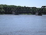 |
1876 | (M) Borough of Ahuntsic-Cartierville Ahuntsic-Cartierville Ahuntsic-Cartierville is a borough of the city of Montreal, Quebec, Canada.-Geography:The borough is located in the northern part of Montreal along the banks of the Rivière des Prairies, and includes some islands in the river such as Île aux Chats, Île Perry, and Île de la Visitation... |
CPR Canadian Pacific Railway The Canadian Pacific Railway , formerly also known as CP Rail between 1968 and 1996, is a historic Canadian Class I railway founded in 1881 and now operated by Canadian Pacific Railway Limited, which began operations as legal owner in a corporate restructuring in 2001... AMT Agence métropolitaine de transport The Agence métropolitaine de transport is the umbrella organization that plans, integrates, and coordinates public transportation services across Canada's Greater Montreal Region, including the Island of Montreal, Laval , and communities along both the North Shore of the Rivière des Mille-Îles... Blainville-Saint-Jerome commuter train Commuter rail in North America Commuter rail services in the United States, Canada, and Mexico provide common carrier passenger transportation along railway tracks, with scheduled service on fixed routes on a non-reservation basis primarily for short-distance travel between a central business district and adjacent suburbs and... Quebec Gatineau Railway Chemins de Fer Québec-Gatineau Les Chemins de fer Québec-Gatineau , in English the Quebec Gatineau Railway is a shortline railway operating the long ex-Canadian Pacific Railway line between Quebec City, Trois-Rivières, Laval, Lachute and Gatineau, formerly Hull... Route Verte Route Verte The Route Verte is a network of bicycling and multiuse trails and designated roads, lanes, and surfaces, spanning 4036 kilometres as of October 31, 2008, in the Canadian province of Quebec, inaugurated on August 10, 2007... 1 and 2 |
Bordeaux, former city | 45°32′53"N 73°41′58"W | |
| (I) Île Perry | |||||||
| (O) Laval (Laval-des-Rapides Laval-des-Rapides Laval-des-Rapides is a neighbourhood in Laval, Quebec, Canada. It was a separate city until the municipal mergers on August 6, 1965.- Geography :... ) |
|||||||
| Médéric Martin Bridge Médéric Martin Bridge Médéric Martin Bridge is a viaduct-type bridge in Quebec that spans Rivière des Prairies between Montreal and Laval. It carries 8 lanes of Quebec Autoroute 15, including 1 reserved bus and carpooling lanes.... |
 |
1958 (widened 1991) | (M) Borough of Ahuntsic-Cartierville Ahuntsic-Cartierville Ahuntsic-Cartierville is a borough of the city of Montreal, Quebec, Canada.-Geography:The borough is located in the northern part of Montreal along the banks of the Rivière des Prairies, and includes some islands in the river such as Île aux Chats, Île Perry, and Île de la Visitation... |
Quebec Autoroute 15 Autoroute 15 is a highway in western Quebec, Canada... |
Médéric Martin Médéric Martin -Background:Born to Salomon Martin, a carpenter and Virginie Lafleur, Martin studied at St. Eustache College and went on to open a cigar store in Montreal's East End and soon became a populist politician, best known for stirring up suspicion against English Montreal residents.-Member of the house... (1869–1946), Mayor of Montreal |
45°32′25"N 73°42′45"W | |
| (O) Laval (Laval-des-Rapides) | |||||||
| Lachapelle Bridge (Cartierville Bridge) Lachapelle Bridge 'Lachapelle Bridge', in French Pont Lachapelle, Also known as Cartierville Bridge.This bridge spans the Rivière des Prairies between the Montreal borough of Ahuntsic-Cartierville and the Laval neighbourhood of Chomedey.Actually there are two bridges, side by side and parallel:The older three... |
 |
1848 | 1930, 1975 | (M) Borough of Ahuntsic-Cartierville | Route 117 Quebec route 117 Route 117 is a provincial highway within the Canadian province of Quebec, running between Montreal and the Quebec/Ontario border where it continues as Highway 66 east of Kearns, Ontario... |
Pascal Persillier-Lachapelle, builder of the first bridge | 45°31′59"N 73°43′43"W |
| (O) Laval (Chomedey Chomedey, Quebec Chomedey is a neighbourhood in the southwest of the city of Laval and was a separate municipality until the municipal mergers on August 6, 1965. Named after Paul Chomedey de Maisonneuve, part of the neighbourhood had previously been known as L'Abord à Plouffe, and was once part of the seigneurie... ) |
|||||||
| Louis Bisson Bridge Louis Bisson Bridge Louis Bisson Bridge spans the Rivière des Prairies between the eastern tip of Montreal's Pierrefonds-Roxboro borough and the district of Chomedey in Laval. It carries 7 lanes of Quebec Autoroute 13, including one reversible lane at the center... |
 |
1975 | (M) Borough of Pierrefonds-Roxboro Pierrefonds-Roxboro Pierrefonds-Roxboro is a borough of the city of Montreal. It is composed of the former municipalities of Pierrefonds and Roxboro, spanning the northern part of the West Island... |
 Quebec Autoroute 13 Autoroute 13 , is a freeway in the urban region of Montreal, Quebec, Canada. Its southern end is at the junction of A-20 on the Island of Montreal near Pierre Elliott Trudeau International Airport. Its northern terminus is at the junction of A-640 near Boisbriand... |
Louis Bisson Louis Bisson Louis Bisson, C.M., O.B.E., LL.B., was a Canadian aviator. He was born in 1909 in Hull, Quebec, Canada. He died on 19 September 1997.He flew for the Royal Air Force Ferry Command during World War II.... (1909–1997), Canadian aviator |
45°30′42"N 73°45′54"W | |
| (O) Laval (Chomedey / Sainte-Dorothée Sainte-Dorothée, Quebec Sainte-Dorothée is a neighbourhood in Laval, Quebec. It was a separate city until the municipal mergers on August 6, 1965.The Sainte-Dorothée that was known for forest and farmlands is no longer what it used to be. It took a giant transformation during the last decade with the arrival of... ) |
|||||||
| Île Bigras railway crossing | 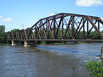 |
1882 | (M) Borough of Pierrefonds-Roxboro Pierrefonds-Roxboro Pierrefonds-Roxboro is a borough of the city of Montreal. It is composed of the former municipalities of Pierrefonds and Roxboro, spanning the northern part of the West Island... |
CN Canadian National Railway The Canadian National Railway Company is a Canadian Class I railway headquartered in Montreal, Quebec. CN's slogan is "North America's Railroad".... (mainly used by AMT Agence métropolitaine de transport The Agence métropolitaine de transport is the umbrella organization that plans, integrates, and coordinates public transportation services across Canada's Greater Montreal Region, including the Island of Montreal, Laval , and communities along both the North Shore of the Rivière des Mille-Îles... Deux-Montagnes commuter train Commuter rail in North America Commuter rail services in the United States, Canada, and Mexico provide common carrier passenger transportation along railway tracks, with scheduled service on fixed routes on a non-reservation basis primarily for short-distance travel between a central business district and adjacent suburbs and... ) |
(no official name) | 45°30′59"N 73°50′52"W | |
| (I) (Île Bigras Îles Laval The Îles Laval are an island grouping in the Rivière des Prairies in southwestern Quebec, part of the Hochelaga ArchipelagoFormerly an independent municipality , they became part of the city of Laval on August 6, 1965.- Geography :... ) Île-Bigras (AMT) Île-Bigras (AMT) Île-Bigras is a commuter rail station on the AMT Deux-Montagnes line in the Greater Montreal, Quebec, Canada area.- Connecting bus routes :There are no Société de transport de Laval bus routes on Île Bigras so most people wanting to use public transit on this small island take the Deux-Montagnes... commuter train Commuter rail in North America Commuter rail services in the United States, Canada, and Mexico provide common carrier passenger transportation along railway tracks, with scheduled service on fixed routes on a non-reservation basis primarily for short-distance travel between a central business district and adjacent suburbs and... station |
|||||||
| (O) Laval (Sainte-Dorothée) | |||||||
| Jacques Bizard Bridge Jacques Bizard Bridge Jacques Bizard Bridge is a bridge that crosses the Rivière des Prairies and connects L'Île Bizard to Montreal Island. Except for a cable ferry that connects Île Bizard with Laval-sur-le-Lac, it is the only access to Île Bizard, which had a population of 13,861 as of the 2001 census. It carries... |
 |
1893 | 1966 | (M) Sainte-Geneviève Sainte-Geneviève, Quebec thumb|upright|left|Église Sainte-GenevièveSainte-Geneviève is a former municipality located on the Island of Montreal in southwestern Quebec, Canada... , Montreal, borough of L'Île-Bizard–Sainte-Geneviève L'Île-Bizard–Sainte-Geneviève L'Île-Bizard–Sainte-Geneviève is a borough of the city of Montreal.-Geography:The borough is composed of the former municipalities of L'Île-Bizard and Sainte-Geneviève. The first is a separate island, the largest of the City of Montreal besides the Island of Montreal itself, and the second is a... |
Boulevard Jacques Bizard | Jacques Bizard Jacques Bizard Jacques Bizard was seigneur of île Bonaventure, later renamed île-Bizard. Born in Benaix, Neuchatel in Switzerland to a Calvinist pastor, Bizard served in the Venetian army where he met Louis de Buade, better known as Comte de Frontenac... (1642–1692), local seigneur |
45°29′15"N 73°52′5"W |
| (O) Île Bizard Île Bizard Île Bizard is an island near the Island of Montreal in the Hochelaga Archipelago region.It was formerly a separate municipality named Ville de L'Île-Bizard, but is now part of the city of Montreal, in the borough of L'Île-Bizard–Sainte-Geneviève.... (Montreal, borough of L'Île-Bizard–Sainte-Geneviève) |
|||||||
Spanning the Lake of Two Mountains and the Ottawa River East Channel
The first railway bridge to Montreal Island was the Grand Trunk RailwayGrand Trunk Railway
The Grand Trunk Railway was a railway system which operated in the Canadian provinces of Quebec and Ontario, as well as the American states of Connecticut, Maine, Michigan, Massachusetts, New Hampshire, and Vermont. The railway was operated from headquarters in Montreal, Quebec; however, corporate...
bridge across the Ottawa River
Ottawa River
The Ottawa River is a river in the Canadian provinces of Ontario and Quebec. For most of its length, it now defines the border between these two provinces.-Geography:...
East Channel. Along with another bridge built simultaneously across the West Channel, this bridge provided the first fixed link from Montreal to the mainland. It was not until 1925, however, that a fixed road link, formed by Galipeault Bridge
Galipeault Bridge
The Galipeault Bridge is a bridge on the western tip of the Island of Montreal, spanning the Ottawa River between Sainte-Anne-de-Bellevue and L'Île-Perrot, Quebec, Canada. It carries four lanes of Autoroute 20, and was named after Antonin Galipeault, who was minister of public works under...
and Taschereau Bridge
Taschereau Bridge
Taschereau Bridge is a bridge linking Pincourt, on Île Perrot, to Vaudreuil-Dorion, in the Vaudreuil-Soulanges RMC across the West Channel of the Ottawa River. The bridge was originally built in 1925, and was doubled in 1964, as part of the same project as Galipeault Bridge, which links the island...
, was built across the Ottawa River from Montreal Island. Perrot Island was the only way out of Montreal to the West before the construction of Île aux Tourtes Bridge
Île aux Tourtes Bridge
The Île aux Tourtes Bridge is a bridge on the western tip of the Island of Montreal, spanning the Lake of Two Mountains between Senneville, and Vaudreuil-Dorion, Quebec, Canada. It carries 6 lanes of Autoroute 40 and is the main link between Montreal and the province of Ontario...
, which goes directly to Vaudreuil across the Lake of Two Mountains.
All three spans across the Ottawa River East Channel are twinned by another span, built simultaneously, across the West Channel.
| Span | Picture | First span built | Current span built | Communities linked | Carries | Name origin | Coordinates Geographic coordinate system A geographic coordinate system is a coordinate system that enables every location on the Earth to be specified by a set of numbers. The coordinates are often chosen such that one of the numbers represent vertical position, and two or three of the numbers represent horizontal position... |
|---|---|---|---|---|---|---|---|
| Île aux Tourtes Bridge Île aux Tourtes Bridge The Île aux Tourtes Bridge is a bridge on the western tip of the Island of Montreal, spanning the Lake of Two Mountains between Senneville, and Vaudreuil-Dorion, Quebec, Canada. It carries 6 lanes of Autoroute 40 and is the main link between Montreal and the province of Ontario... |
1966 | (M) Senneville Senneville, Quebec Senneville is a village on the western tip of the Island of Montreal. It is the wealthiest town on the West Island, closely followed by Dollard-des-Ormeaux and Baie D'Urfé... |
Quebec Autoroute 40 Autoroute 40 is a major highway on the north shore of the St. Lawrence River in Quebec, Canada. It is one of the two main connections between Montreal and Quebec City... |
Île aux Tourtes (literally, Wild Pigeon island) | 45°25′13"N 73°59′7"W (Across Lake of Two Mountains) |
||
| (I) Île Girwood, Île aux Tourtes | |||||||
| (O) Vaudreuil-Dorion | |||||||
| Canadian Pacific Rail Bridge | 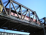 |
1893 | (M) Sainte-Anne-de-Bellevue Sainte-Anne-de-Bellevue, Quebec Sainte-Anne-de-Bellevue is a town located at the western tip of the Island of Montreal in southwestern Quebec, Canada. It is the second oldest community in Montreal's West Island, having been founded as a parish in 1703... |
CPR (AMT Agence métropolitaine de transport The Agence métropolitaine de transport is the umbrella organization that plans, integrates, and coordinates public transportation services across Canada's Greater Montreal Region, including the Island of Montreal, Laval , and communities along both the North Shore of the Rivière des Mille-Îles... Vaudreuil-Hudson commuter train Commuter rail in North America Commuter rail services in the United States, Canada, and Mexico provide common carrier passenger transportation along railway tracks, with scheduled service on fixed routes on a non-reservation basis primarily for short-distance travel between a central business district and adjacent suburbs and... ) |
(no official names) | 45°24′12"N 73°57′24"W (Across Canal Sainte-Anne) |
|
| (I) Île Bellevue | |||||||
| (O) Île Perrot Île Perrot Île Perrot is an island west of the island of Montreal in the Canadian province of Quebec. Part of the Hochelaga Archipelago, the island lies between Lake Saint-Louis and Lac des Deux-Montagnes.... |
|||||||
| Canadian National Rail Bridge | 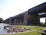 |
1854 | (M) Sainte-Anne-de-Bellevue | CN Via Rail Canada VIA Rail Via Rail Canada is an independent crown corporation offering intercity passenger rail services in Canada. It is headquartered near Montreal Central Station at 3 Place Ville-Marie in Montreal, Quebec.... passenger trains to Ottawa Ottawa Ottawa is the capital of Canada, the second largest city in the Province of Ontario, and the fourth largest city in the country. The city is located on the south bank of the Ottawa River in the eastern portion of Southern Ontario... /Toronto Toronto Toronto is the provincial capital of Ontario and the largest city in Canada. It is located in Southern Ontario on the northwestern shore of Lake Ontario. A relatively modern city, Toronto's history dates back to the late-18th century, when its land was first purchased by the British monarchy from... |
45°24′12"N 73°57′24"W (Across Canal Sainte-Anne) |
||
| (I) Île Bellevue | |||||||
| (O) Île Perrot | |||||||
| Galipeault Bridge Galipeault Bridge The Galipeault Bridge is a bridge on the western tip of the Island of Montreal, spanning the Ottawa River between Sainte-Anne-de-Bellevue and L'Île-Perrot, Quebec, Canada. It carries four lanes of Autoroute 20, and was named after Antonin Galipeault, who was minister of public works under... |
 |
1925 | 1991, 2009 | (M) Sainte-Anne-de-Bellevue | Quebec Autoroute 20 Autoroute 20 is a major Quebec Autoroute, following the Saint Lawrence River through one of the more densely-populated parts of Canada, and is part of the Trans-Canada Highway. At , it is the longest Autoroute in Quebec... and Route Verte Route Verte The Route Verte is a network of bicycling and multiuse trails and designated roads, lanes, and surfaces, spanning 4036 kilometres as of October 31, 2008, in the Canadian province of Quebec, inaugurated on August 10, 2007... 5 |
Antonin Galipeault Antonin Galipeault Antonin Galipeault was a Québécois politician, lawyer and judge .-Biography:Antonin Galipeault studied at a seminary in Joliette and at Université Laval, later being admitted to the Bar of Quebec in 1900.He worked as a lawyer alongside Joseph-Napoléon Francoeur and Louis Saint-Laurent and later... (1879–1971), Quebec politician |
45°24′10"N 73°57′21"W (Across Canal Sainte-Anne) |
| (I) Île Bellevue | |||||||
| (O) Île Perrot | |||||||
See also
- Crossings of the Canal de l'Aqueduc
- Crossings of the Lachine Canal
- List of crossings of the Ottawa River
- List of crossings of the Rivière des Mille Îles
- List of crossings of the Rivière des Prairies
- List of crossings of the Saint Lawrence River
- List of hydroelectric stations
- List of bridges in Canada