

List of Grade III historic buildings in Hong Kong
Encyclopedia
Grade III historic buildings (香港三級歷史建築列表) are those selected by Hong Kong
's Antiquities and Monuments Office
as those buildings which are "Buildings of some merit, but not yet qualified for consideration as possible monuments. These are to be recorded and used as a pool for future selection."
Note: This list is accurate as at 6 November 2009. A territory-wide grade reassessment
has been ongoing since. See this link for the latest grading update.
Central and Western District
Eastern District
Islands District
Kowloon City District
North District
Sai Kung District
Sha Tin District
Sham Shui Po District
Southern District
Tai Po District
Tsuen Wan District
Tuen Mun District
Wan Chai District
Wong Tai Sin District
Yau Tsim Mong District
Yuen Long District
Hong Kong
Hong Kong is one of two Special Administrative Regions of the People's Republic of China , the other being Macau. A city-state situated on China's south coast and enclosed by the Pearl River Delta and South China Sea, it is renowned for its expansive skyline and deep natural harbour...
's Antiquities and Monuments Office
Antiquities and Monuments Office
Antiquities and Monuments Office was established when the Antiquities and Monuments Ordinance was enacted in 1976, to preserve Hong Kong's monuments under appropriate protection....
as those buildings which are "Buildings of some merit, but not yet qualified for consideration as possible monuments. These are to be recorded and used as a pool for future selection."
Note: This list is accurate as at 6 November 2009. A territory-wide grade reassessment
Heritage conservation in Hong Kong
This article details the history and status of Heritage conservation in Hong Kong, as well as the role of various stakeholders.An indication of the size of the built heritage in Hong Kong is given by a territory-wide survey conducted by the Antiquities and Monuments Office between 1996 and 2000,...
has been ongoing since. See this link for the latest grading update.
Central and Western DistrictCentral and Western DistrictThe Central and Western District located on northern part of Hong Kong Island is one of the 18 administrative districts of Hong Kong. It had a population of 261,884 in 2001...
| Name | Location | Notes/References | Photographs |
|---|---|---|---|
| Elliot Pumping Station & Filters Workmen's Quarters | Pok Fu Lam Road Pok Fu Lam Road Pokfulam Road, or Pok Fu Lam Road, is a four-lane road in Hong Kong. Built on Hong Kong Island, the road runs between Sai Ying Pun and Wah Fu, through Pok Fu Lam.... , Kennedy Town Kennedy Town Kennedy Town is at the western end of Sai Wan on Hong Kong Island in Hong Kong. It was named after Arthur Edward Kennedy, the 7th Governor of Hong Kong from 1872 to 1877... |
http://www.lcsd.gov.hk/CE/Museum/Monument/en/trails_west1.php?tid=11 | |
| Elliot Pumping Station & Filters, Treatment Works Building | Pok Fu Lam Road, Kennedy Town | ||
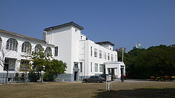
| London Mission Building | Nos. 78-80 Robinson Road Robinson Road, Hong Kong Robinson Road is a 2-lane, bi-directional road on the Mid-levels, Hong Kong Island, Hong Kong. In the east, it is connected with the Magazine Gap Road and Garden Road, and in the west with Babington Road and Park Road, Robinson Road is quite long. With Central-Mid-Levels escalator, it also... , Mid-levels Mid-levels Mid-levels is an expensive residential area on Hong Kong Island in Hong Kong. It is located halfway up Victoria Peak, directly above Central... |
http://www.amo.gov.hk/en/trails_sheungwan2.php?tid=7 Now a private clubhouse. | |
| Main Block, Tung Wah Hospital Tung Wah Hospital Tung Wah Hospital is a hospital in Hong Kong under the Tung Wah Group of Hospitals. Located above Possession Point, at 12 Po Yan Street in Sheung Wan, it is the first hospital established in Colonial Hong Kong for the general public in the 1870s.-History:The hospital was declared for construction... |
No. 12 Po Yan Street, Sheung Wan Sheung Wan Sheung Wan is an area in Hong Kong, located in the north-west of Hong Kong Island, between Central and Sai Ying Pun. Administratively, it is part of the Central and Western District... |
http://www.lcsd.gov.hk/ce//Museum/Monument/en/trails_sheungwan1.php?tid=27 |  |
| Matilda and War Memorial Hospital Matilda International Hospital Matilda International Hospital is a hospital in Hong Kong located at 41 Mount Kellett Road, The Peak. The hospital was built as a result of the last will and testament of Granville Sharp, the husband of Matilda Lincolne Sharp... |
No. 41 Mount Kellet Road, The Peak Victoria Peak Victoria Peak is a mountain in Hong Kong. It is also known as Mount Austin, and locally as The Peak. The mountain is located in the western half of Hong Kong Island... |
||
| No.28 Kennedy Road (Office of Former Chief Executives Chief Executive of Hong Kong The Chief Executive of Hong Kong is the President of the Executive Council of Hong Kong and head of the Government of the Hong Kong Special Administrative Region. The position was created to replace the Governor of Hong Kong, who was the head of the Hong Kong government during British rule... ) |
No. 28 Kennedy Road Kennedy Road, Hong Kong Kennedy Road is a road in the Mid-levels on the Hong Kong Island, Hong Kong. Starting from Garden Road in the west, it goes past St. Joseph's College, Hong Kong Visual Arts Centre, Hong Kong Park and Hopewell Centre and ends at the junction with Queen's Road East near Morrison Hill in Wan Chai.At... , Central Central, Hong Kong Central is the central business district of Hong Kong. It is located in Central and Western District, on the north shore of Hong Kong Island, across Victoria Harbour from Tsim Sha Tsui, the southernmost point of Kowloon Peninsula... |
http://www.admwing.gov.hk/eng/links/fceo.htm |  |
| Old Victoria Hospital Maternity Block | No. 17 Barker Road, The Peak | ||
| Peak Police Station | No. 92 Peak Road, The Peak | ||
| St. Louis School St. Louis School, Hong Kong Established1927School TypeCatholic Govt. Subsidized Organizing BodySalesians of Don BoscoSupervisorFr. Simon LamPrincipalFr. Ng Dor Lok PeterStudentsBoysEnrolmentApprox... |
No. 179 Third Street Third Street (Hong Kong) Third Street , is a street in Sai Ying Pun neighbourhood of Hong Kong. It runs one way from Pok Fu Lam Road, then crosses Water Street, then Pok Fu Lam Road again, then western, Centre Streets and terminates at Eastern Street.... , Sai Ying Pun Sai Ying Pun Sai Ying Pun is an area in Western District on the Hong Kong Island in Hong Kong. It is part of Central and Western District in district administration.... |
http://www.lcsd.gov.hk/CE/Museum/Monument/en/trails_west1.php?tid=22 | 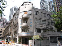 |
| St. Paul's Co-educational College St. Paul's Co-educational College St. Paul's Co-educational College , is located at 33 MacDonnell Road, Mid-levels, Hong Kong.... |
No. 33 MacDonnell Road MacDonnell Road MacDonnell Road, is a road in the affluent and ultra-expensive Mid-Levels district on Hong Kong Island, Hong Kong. MacDonnell Road is named after former Hong Kong Governor Richard Graves MacDonnell. Starting from Garden Road, the road runs westward in the Mid-Levels and ends in Kennedy Road.The... , Central |
 |
|
| Stone House | No. 15 Kotewall Road Kotewall Road Kotewall Road, , is a road in Mid-Levels, Hong Kong Island. Located between Po Shan Road and Robinson Road.- The name :Sir Robert Hormus Kotewall was a prominent businessman. In 1913, he was named Clerk to the Magistracy and JP. By 1919, Dr Kotewall was in trade as the manager of the Hong Kong... , Mid-levels |
http://www.lcsd.gov.hk/CE/Museum/Monument/en/trails_west2.php?tid=7 Now a private residence. | |
| Tsung Tsin Mission of Hong Kong Kau Yan Church | No. 97A High Street High Street, Hong Kong High Street is a one way street in Sai Ying Pun, Hong Kong, available only to minibuses and private vehicles. It connects Bonham Road in the east and Pok Fu Lam Road in the west. It runs from east to west from Western St to Pok Fu Lam Road, and from west to east from Western Street to Bonham Road... , Sai Ying Pun |
http://www.lcsd.gov.hk/CE/Museum/Monument/en/trails_west1.php?tid=15 | 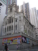 |
| West Point Filters Workmen's Quarters | No. 50 Kotewall Road, Mid-levels | Now par of the Lung Fu Shan Environmental Education Centre. | |
| West Point Filters Workmen's Quarters | No. 50 Kotewall Road, Mid-levels | Now par of the Lung Fu Shan Environmental Education Centre. | |
| Ex-Western Fire Station | No. 12 Belcher's Street Belcher's Street Belcher's Street is a main street in Kennedy Town of Hong Kong. It connects east Victoria Road and joins west Queen's Road West. A small section in its west end built a turn around for Hong Kong Tramway.... , Kennedy Town |
http://www.lcsd.gov.hk/CE/Museum/Monument/en/trails_west1.php?tid=23 Converted into the Po Leung Kuk Po Leung Kuk The Po Leung Kuk is a charitable organisation in Hong Kong that provides support for orphaned children, education and other services.-Founding of Po Leung Kuk:... Chan Au Big Yan Home for the Elderly. |
 |
| Old Tsan Yuk Maternity Hospital Old Tsan Yuk Maternity Hospital The Old Tsan Yuk Maternity Hospital is located at No. 36A Western Street, Sai Ying Pun, Hong Kong. It was founded in 1922 under the Chinese Public Dispensary Committee... |
No. 36A Western Street Western Street (Hong Kong) Western Street is an uphill one way street in Sai Ying Pun, Hong Kong. It connects Bonham Road in the south and Connaught Road West in the north. There are 337 units in 17 buildings in the street. Addresses are odd on the west side of the street, and mostly even on the east side... , Sai Ying Pun |
http://www.lcsd.gov.hk/CE/Museum/Monument/en/trails_west1.php?tid=16 Named "Western District Community Centre" since 1973. |  |
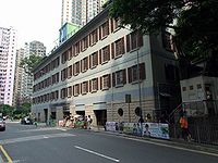
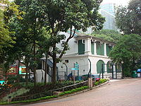
| Old Upper Levels Police Station | No. 1F High Street, Sai Ying Pun | http://www.lcsd.gov.hk/CE/Museum/Monument/en/trails_west1.php?tid=21 Now used as the Crime Hong Kong Island Regional Headquarters. |  |
| Central Market | No. 80 Des Voeux Road Des Voeux Road Des Voeux Road Central and Des Voeux Road West are two roads on the north shore of Hong Kong Island, Hong Kong. They were named after the 10th Governor of Hong Kong, Sir George William Des Vœux... , Central |
http://www.amo.gov.hk/en/trails_sheungwan2.php?tid=2 |  |
Eastern DistrictEastern District, Hong KongThe Eastern District is one of the 18 districts of Hong Kong. It had a population of 587,690 in 2006. The district has the second highest population while its residents have the third highest median household income among 18 districts....
| Name | Location | Notes/References | Photographs |
|---|---|---|---|
| Former Quarry Bay School | No. 986 King's Road King's Road, Hong Kong King's Road is a major east-west street along the northern shore of Hong Kong Island, Hong Kong, extending from Causeway Bay, where it joins Causeway Road, to Sai Wan Ho, where it joins Shau Kei Wan Road.-History:... , Quarry Bay Quarry Bay Quarry Bay is an area beneath Mount Parker in the Eastern District of Hong Kong Island, in Hong Kong. The western portion of the area was also formerly known as Lai Chi... |
||
| Lyemun Barracks Block 17 | Lei Yue Mun Lei Yue Mun Lei Yue Mun is a short channel in Hong Kong, between Junk Bay and Victoria Harbour, separating Kowloon and Hong Kong Island. The channel is an important passage in the South China Sea. It is the east gate of Victoria Harbour.The lands around the channel are also called Lei Yue Mun... , Chai Wan Chai Wan Chai Wan , formerly mistakenly known as Sai Wan , lies at the east end of the urban area of Hong Kong Island next to Shau Kei Wan. The area is administratively part of the Eastern District, and is a mosaic of industrial and residential areas... |
||
| Lyemun Barracks Block 03 | Lei Yue Mun, Chai Wan | ||
| Lyemun Barracks Block 05 | Lei Yue Mun, Chai Wan | ||
| Lyemun Barracks Block 20 | Lei Yue Mun, Chai Wan | ||
| Lyemun Barracks Block 30 | Lei Yue Mun, Chai Wan | ||
| Lyemun Barracks Block 31 | Lei Yue Mun, Chai Wan | ||
| Lyemun Barracks Block 32 | Lei Yue Mun, Chai Wan | ||
| Lyemun Barracks Block 33 | Lei Yue Mun, Chai Wan | ||
| Lyemun Barracks Block 34 | Lei Yue Mun, Chai Wan | ||
Islands DistrictIslands DistrictThe Islands District is one of the 18 districts of Hong Kong. It is part of the New Territories. It had a population of 137,122 in 2009.Hong Kong consists of a peninsula and 236 islands...
| Name | Location | Notes/References | Photographs |
|---|---|---|---|
| Cheung Chau Fong Pin Hospital | Cheung Chau Cheung Chau Cheung Chau is a small island 10 km southwest of Hong Kong Island, is nicknamed as the 'dumbbell island' for its shape. It has been inhabited for longer than most other places in the territory of Hong Kong, with a population of about 23,000 up to 2006... |
||
| Cheung Chau Government Secondary School | No. 5B School Road, Cheung Chau | ||
| Cheung Chau Police Station | No. 4 Police Station Path, Cheung Chau | ||
| Old Tai O Police Station Old Tai O Police Station The Old Tai O Police Station is a former police station in Hong Kong. It is located on the small hill next to Tai O Ferry Pier, at the south-western tip of Tai O, which canbe considered the very west part within Hong Kong.-History:... |
Shek Tsai Po Street, Tai O Tai O Tai O is a fishing town, partly located on an island of the same name, on the western side of Lantau Island in Hong Kong.-Geography:On the main part of Lantau Island, a river splits to the north and west and at this fork lies the island referred to as Tai O. Two pedestrian bridges cross the river... , Lantau Island Lantau Island Lantau Island , based on the old local name of Lantau Peak , is the largest island in Hong Kong, located at the mouth of the Pearl River. Administratively, most of Lantau Island is part of the Islands District of Hong Kong... |
 |
|
| Shui Yuet Temple | Kwun Yam Wan, Cheung Chau | ||
| Tin Hau Temple Tin Hau temples in Hong Kong Over 70 temples are dedicated to Tin Hau in Hong Kong. They include:* Tin Hau temple, located at 10 Tin Hau Temple Road, Causeway Bay, east of Victoria Park, in Eastern District, on Hong Kong Island. It is a declared monument. The temple has given its name to the MTR station serving it .* The Tin... |
Fan Lau Miu Wan, Fan Lau Fan Lau Fan Lau is peninsula and area in the southwest tip of Lantau Island in Hong Kong. It is also the southwest end the territory of Hong Kong. The very end of the tip is Fan Lau Kok . The peninsula separates water into Fan Lau Tung Wan in the east, and Fan Lau Sai Wan and Fan Lau Miu Wan Fan Lau... , Lantau Island |
||
| Tin Hau Temple Tin Hau temples in Hong Kong Over 70 temples are dedicated to Tin Hau in Hong Kong. They include:* Tin Hau temple, located at 10 Tin Hau Temple Road, Causeway Bay, east of Victoria Park, in Eastern District, on Hong Kong Island. It is a declared monument. The temple has given its name to the MTR station serving it .* The Tin... |
Sai Wan Sai Wan (bays) Sai Wan is the name of:Sai Wan is also the former name of Chai Wan*Sai Wan War Cemetery* Sai Wan, Western District-Bays:*Sai Wan, Cheung Chau*Sai Wan, Ma Wan*Sai Wan, Sai Kung*Sai Wan, Tai A Chau*Fan Lau Sai Wan*Kau Sai Wan-See also:... , Cheung Chau |
||
Kowloon City DistrictKowloon City DistrictKowloon City District is one of the 18 districts of Hong Kong. It is located in Kowloon. It had a population of 381,352 in 2001. The district has the third most educated residents while its residents enjoy the highest income in Kowloon....
| Name | Location | Notes/References | Photographs |
|---|---|---|---|
| Diocesan Boys' School Diocesan Boys' School Diocesan Boys' School is a boys' school located at 131 Argyle Street, Mong Kok, Kowloon, Hong Kong. It was founded in 1869, making it one of the oldest secondary schools in Hong Kong.... |
No. 131 Argyle Street Argyle Street, Hong Kong Argyle Street is a four-lane dual-way thoroughfare in Hong Kong, connecting Mong Kok, Ma Tau Wai and Kowloon City. It runs on an east-west alignment starting at its intersection with Cherry Street, Ferry Street and Tong Mi Road in the west, and ending near the former Kai Tak Airport in the east.The... , Mong Kok Mong Kok Mong Kok , less often known as Argyle , is an area in the Yau Tsim Mong District on Kowloon Peninsula, Hong Kong... |
 |
|
| Heep Yunn School Heep Yunn School Heep Yunn School is an Anglican girls' secondary school founded in 1936. It is located in Ma Tau Wai, Kowloon, Hong Kong.Heep Yunn is notable for its students' high academic achievement... |
No. 1 Farm Road, Ho Man Tin Ho Man Tin Ho Man Tin is a mostly residential area in Kowloon, Hong Kong, part of the Kowloon City District.-History:The original area of Ho Man Tin was quite different from the present-day one. It was located in the heart of nowaday Mong Kok. With cultivated lands,... |
 |
|
| Holy Trinity Church | No. 135 Ma Tau Chung Road | ||
| Kowloon Hospital Kowloon Hospital Kowloon Hospital is a general care hospital at Prince Edward Road in Mong Kok of Kowloon in Hong KongThe hospital used to be an acute hospital with accident and emergency service. It was later converted to a chronic hospital to provide extended supportive care to patients from Queen Elizabeth... |
No. 147A Argyle Street, Mong Kok |  |
|
| Pak Tai Temple | No. 146 Ma Tau Wai Road, Hung Hom Hung Hom Hung Hom is an area of Kowloon, in Hong Kong, administratively part of the Kowloon City District, with a portion west of the railway in the Yau Tsim Mong District. Hung Hom serves mainly residential purposes though is mixed with some industrial buildings in the north.-Geography:Hung Hom is located... |
http://www.ctc.org.hk/en/directcontrol/temple18.asp | .jpg) |
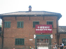
| Ex-Ma Tau Kok Ma Tau Kok Ma Tau Kok is a place between To Kwa Wan and Ma Tau Chung in Hong Kong. It was a cape in Kowloon Bay in Victoria Harbour and opposite to the Sacred Hill at Ma Tau Chung.-Cattle Depot Artist Village:right|275px|thumb|Cattle Depot Artists Village... Animal Quarantine Depot |
No. 63 Ma Tau Kok Road, To Kwa Wan To Kwa Wan To Kwa Wan is a bay and an area of the eastern shore of Kowloon peninsula of Hong Kong. The area is part of urban Hong Kong, and is adjacent to Hok Yuen, Hung Hom, Ma Tau Wai and Ma Tau Kok... |
http://hk-magazine.com/feature/saving-face Converted into the Cattle Depot Artist Village Cattle Depot Artist Village Cattle Depot Artist Village is located on 63 Ma Tau Kok Road, To Kwa Wan, Kowloon, Hong Kong. The site was originally used as a slaughterhouse from 1908 to 1999. It was renovated and developed into a village for artists in 2001. It is now home to around 20 art groups... |
 |
| Tin Hau Temple Tin Hau temples in Hong Kong Over 70 temples are dedicated to Tin Hau in Hong Kong. They include:* Tin Hau temple, located at 10 Tin Hau Temple Road, Causeway Bay, east of Victoria Park, in Eastern District, on Hong Kong Island. It is a declared monument. The temple has given its name to the MTR station serving it .* The Tin... |
No. 49 Ha Heung Road, To Kwa Wan | http://www.ctc.org.hk/en/directcontrol/temple11.asp |  |
North DistrictNorth District, Hong KongNorth District is the northernmost district of the 18 districts of Hong Kong. It is located in the northwestern part of the New Territories. The new town of Fanling-Sheung Shui is within this district. It had a population of 298,657 in 2001. The district has the second lowest population density.It...
| Name | Location | Notes/References | Photographs |
|---|---|---|---|
| Bok Man School | Tsung Pak Long Village, Sheung Shui Sheung Shui Sheung Shui is an area in New Territories, Hong Kong. Sheung Shui Town, a part of this area, is part of the Fanling-Sheung Shui New Town in the North District of Hong Kong. Fanling Town is to its southeast.-History:... |
 |
|
| Hung Leng Station | Fanling-Sha Tau Kok Branch Line Sha Tau Kok Railway The Sha Tau Kok Railway was a gauge narrow gauge railway running from Fanling to Sha Tau Kok in the northern New Territories of Hong Kong. The line began service on 1st April 1912. It was built with the narrow gauge tracks of the Kowloon-Canton Railway when the latter was converted to standard... , Sha Tau Kok Road, Hung Leng |
 |
|
| Manor House | Kwu Tung Kwu Tung Kwu Tung is an area in the northern New Territories, west of Sheung Shui and Fanling, and east of Lok Ma Chau and San Tin, in Hong Kong.Kwu Tung literally means "old cave" in the Cantonese language. Tung also indicates that it was the habitat of ancient native Cantonese people... , Sheung Shui |
||
| Lady Ho Tung Welfare Centre | No. 38 Kwu Tung, Sheung Shui |  |
|
| Old Sheung Shui Police Station | Sheung Shui Heung, Sheung Shui | 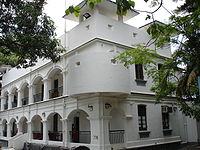 |
|
| Tsung Kyam Church or Shung Him Church | No. 20 Shung Him Tong Tsuen, Lung Yeuk Tau Lung Yeuk Tau Lung Yeuk Tau , commonly known as Lung Ku Tau and also called Lung Ling is an area located northeast of Luen Wo Hui in Fanling, New Territories, Hong Kong.... , Fanling Fanling Fanling , also known as Fan Ling and Fan Leng, is an area in the New Territories of Hong Kong. Administratively, it is part of the North District... |
http://www.amo.gov.hk/en/trails_lung1.php?tid=11 |  |
| Sin Wai Nunnery | Ho Sheung Heung, Sheung Shui | ||
| Ta Kwu Ling Police Station | Ping Che Road, Ta Kwu Ling Ta Kwu Ling Ta Kwu Ling is an area in the North District, New Territories, Hong Kong, located northeast of Sheung Shui, close to the border with mainland China.... |
||
Sai Kung DistrictSai Kung DistrictSai Kung District is the second largest district in Hong Kong in terms of area. It comprises the southern half of Sai Kung Peninsula and Clear Water Bay Peninsula in the New Territories plus a strip to the east of Kowloon. The administrative centre is Sai Kung Town but the district's population is...
| Name | Location | Notes/References | Photographs |
|---|---|---|---|
| Hong Kong Adventist College Hong Kong Adventist College Hong Kong Adventist College is a co-educational institution of higher learning located in Sai Kung, New Territories, Hong Kong. The college is owned and operated by the Seventh-day Adventist Church.- History :... & Hong Kong Adventist Academy Hong Kong Adventist Academy Infobox School|name =Hong Kong Adventist Academy|native_name =|image =Hong Kong Adventist Academy logo.png|imagesize = 200px|caption =... |
No. 1111 Clear Water Bay Road Clear Water Bay Road Clear Water Bay Road is a major road from a complex interchange in Ngau Chi Wan to a dead end in Clear Water Bay, Sai Kung. It also is a route to Sai Kung Town and Tseung Kwan O via Hang Hau Road and Hiram's Highway respectively... , Sheung Yeung |
||
| Hung Shing Temple Hung Shing Temple Hung Shing Temples or Tai Wong Temples are temples dedicated to Hung Shing. Hung Shing temples have been widely built in southern China, especially Guangdong province and in Hong Kong.-Existing temples:... |
Po Toi O Po Toi O Po Toi O is a small fishing village at Clear Water Bay Peninsula, Sai Kung, New Territories, Hong Kong.The village is situated at a bay shaped like a sack, thus earning its name Po Toi... |
||
| Hung Shing Temple Hung Shing Temple Hung Shing Temples or Tai Wong Temples are temples dedicated to Hung Shing. Hung Shing temples have been widely built in southern China, especially Guangdong province and in Hong Kong.-Existing temples:... |
Tung Lung Island Tung Lung Chau Tung Lung Chau , also known as Nam Tong Island is an island located off the tip of the Clear Water Bay Peninsula in the New Territories of Hong Kong. It is also referred by Hong Kong people as Tung Lung To or Tung Lung Island .The island is largely uninhabited... |
||
| Tin Hau Temple Tin Hau temples in Hong Kong Over 70 temples are dedicated to Tin Hau in Hong Kong. They include:* Tin Hau temple, located at 10 Tin Hau Temple Road, Causeway Bay, east of Victoria Park, in Eastern District, on Hong Kong Island. It is a declared monument. The temple has given its name to the MTR station serving it .* The Tin... and Hip Tin Hip Tin There are several Hip Tin Temples in Hong Kong. Kwan Tai is worshiped in these temples. The table provides a partial list of these temples.... Temple |
Po Tung Road |  |
|
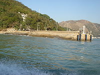
| Immaculate Conception Chapel | Tai Long | ||
| St. Joseph's Chapel | Yim Tin Tsai Yim Tin Tsai (Sai Kung) Yim Tin Tsai is a small offshore island in Sai Kung, Hong Kong. There is no permanent population on the island.-Geography:... |
Completed in 1890. | 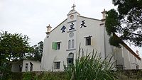 |
Sha Tin DistrictSha Tin DistrictSha Tin District is one of the 18 districts of Hong Kong. One of the 9 districts located in the New Territories, it covers the areas of Sha Tin, Tai Wai, Ma On Shan, Fo Tan, Siu Lek Yuen and Ma Liu Shui . The district has the highest population...
| Name | Location | Notes/References | Photographs |
|---|---|---|---|
| High Rock Christian Camp | No. 102 Sha Tin Tau Village | ||
| Lam Ancestral Hall | Nos.8, 10-14 Pai Tau | 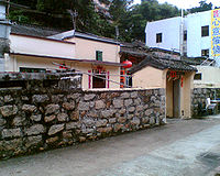 |
|
| Man Fat Tsz Main Temple Building | Pai Tau Hang | Ten Thousand Buddhas Monastery Ten Thousand Buddhas Monastery Ten Thousand Buddhas Monastery is a Buddhist temple in Sha Tin, Hong Kong. It is located at 220 Pai Tau Village, Sha Tin. It is not an actual monastery as there are no resident monks and is managed by laypersons.-Historic background:... |
|
| Man Fat Tsz Pagoda | Pai Tau Hang | .jpg) |
|
| Shek Lei Pui Treatment Works - Two connected Treatment Works Buildings | Kam Shan Country Park Kam Shan Country Park Kam Shan Country Park , established on 24 June 1977, is a country park located in the ranges north of Kowloon, Hong Kong. It covers an area of 3.37 km². Most of the area is covered by the Kowloon Group of Reservoirs. Inside the park, there are jogging trails, barbecue and picnic areas, which... |
||
| Shek Lei Pui Treatment Works - Chemical House | Kam Shan Country Park | ||
Sham Shui Po DistrictSham Shui Po DistrictSham Shui Po District is one of 18 districts of Hong Kong. It covers the Shek Kip Mei, Sham Shui Po, Cheung Sha Wan, Lai Chi Kok and Yau Yat Chuen areas of New Kowloon, and Stonecutter's Island of Kowloon...
| Name | Location | Notes/References | Photographs |
|---|---|---|---|
| Some buildings/military facilities within the Ngong Shuen Chau Barracks | Stonecutters Island Stonecutters Island Stonecutters Island or Ngong Shuen Chau is a former island in Victoria Harbour, Hong Kong. Following land reclamation, it is now annexed to the Kowloon peninsula.-Fauna:... |
Some buildings/facilities also Grade I and II | |
| Lai Chi Kok Hospital | No. 800 Castle Peak Road Castle Peak Road Castle Peak Road is the longest road in Hong Kong. It runs from Tai Po Road in Sham Shui Po, Kowloon to the very north of the New Territories, serving south, west and north New Territories, being one of the most distant roads in early Hong Kong.-Name:... , Lai Chi Kok Lai Chi Kok Lai Chi Kok is a neighborhood in New Kowloon, Hong Kong, east of Kwai Chung and west of Cheung Sha Wan. Mei Foo Sun Chuen is the largest housing estate in the area. Administratively, it belongs to the Sham Shui Po District.-History:... |
http://www.thestandard.com.hk/news_detail.asp?pp_cat=11&art_id=42812&sid=13239082&con_type=3 http://www.hksaross.org/oss/11.pdf http://www.heritage.gov.hk/en/gallery/photo2008/photo_20080222_04.htm | |
| Sham Shui Po Police Station Sham Shui Po Police Station Sham Shui Po Police Station situates at the junction of Lai Chi Kok Road and Yen Chow Street, Sham Shui Po. It was built in 1924 with three storeys.It is graded as Grade III historic building.... |
No. 37A Yen Chow Street Yen Chow Street Yen Chow Street is a main street in Sham Shui Po of New Kowloon in Hong Kong. The street runs from hill side towards the shore. It spans from Castle Peak Road to Sham Mong Road. Its extension Yen Chow Street West spans further to the reclamation shore.-Name:The street was named after Yen Chow,... , Sham Shui Po Sham Shui Po Sham Shui Po, or Shamshuipo, is an area of Sham Shui Po District, Hong Kong, situated in the northwestern part of the Kowloon Peninsula, north of Tai Kok Tsui, east of Cheung Sha Wan and south of Shek Kip Mei. Sham Shui Po is known for its street market for electronic devices.-History:Sham Shui Po... |
 |
|
| Sham Shui Po Public Dispensary | No. 137 Yee Kuk Street, Sham Shui Po | http://thaiworldview.com/hongkong/kowloon/shamshuipo2.htm Now used as a Public Dispensary and Methadone Clinic |  |
| Tin Hau Temple Tin Hau temples in Hong Kong Over 70 temples are dedicated to Tin Hau in Hong Kong. They include:* Tin Hau temple, located at 10 Tin Hau Temple Road, Causeway Bay, east of Victoria Park, in Eastern District, on Hong Kong Island. It is a declared monument. The temple has given its name to the MTR station serving it .* The Tin... |
No.180-184 Yee Kuk Street, Sham Shui Po | http://www.ctc.org.hk/en/directcontrol/temple15.asp | 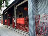 |
Southern DistrictSouthern District, Hong KongThe Southern District is one of the 18 districts of Hong Kong. It is located in the southern part of Hong Kong Island. It had a population of 290,240 in 2001. This district has the fourth lowest population of Hong Kong.-Geography:...
| Name | Location | Notes/References | Photographs |
|---|---|---|---|
| Aberdeen Reservoir, Lower Reservoir, Pump House | Aberdeen Reservoir Road, Aberdeen | ||
| Aberdeen Reservoir, Lower Reservoir, Valve House | Aberdeen Reservoir Road, Aberdeen | ||
| Aberdeen Reservoir, Lower Reservoir, Aberdeen Management Centre | Aberdeen Reservoir Road, Aberdeen | ||
| Aberdeen Reservoir, Lower Reservoir, Chemical House and Air Vents | Aberdeen Reservoir Road, Aberdeen | 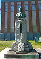 |
|
| Aberdeen Technical School | No. 1 Wong Chuk Hang Road Wong Chuk Hang Road Wong Chuk Hang Road is a major thoroughfare in southern Hong Kong Special Administrative Region, China. It is part of Hong Kong Route 1. It is a 6 laned major thoroughfare. A flyover is established for Wong Chuk Hang Road. The flyover is 550 metres long. With 4 lanes, the flyover costs 35.8... , Aberdeen |
 |
|
| Former Wong Nai Chung Reservoir Workmen's Quarters | Tai Tam Reservoir Road, Wong Nai Chung | ||
| Magazine Building | Magazine Island Magazine Island Magazine Island , originally known as One Tree Island is an island of Hong Kong, located off the southwest coast of Hong Kong Island, and off the northwestern tip of Ap Lei Chau. Administratively, it is part of Southern District.... , Pok Fu Lam Pok Fu Lam Pok Fu Lam or Pokfulam is a residential area on Hong Kong Island, at the western end of the Southern District.Pok Fu Lam is a valley between Victoria Peak and Mount Kellet, around Telegraph Bay.... |
|
|
| Old Aberdeen Police Station | No. 116 Aberdeen Main Road Aberdeen Main Road Aberdeen Main Road, , is a major road in Aberdeen, Hong Kong.- Nearby :* Aberdeen Centre, Hong Kong* Tin Hau Temple, Aberdeen* Aberdeen Chinese Permanent Cemetery* Aberdeen Reservoir Road* Aberdeen Reservoir* Aberdeen Market... , Aberdeen |
It now houses the Warehouse Teenage Club |  |
| Red-Brick Building, Tai Tam Reservoir | Near the Tai Tam Byewash Reservoir, off Tai Tam Road Tai Tam Road Tai Tam Road in Hong Kong, links between Chai Wan and Stanley, on Hong Kong Island. The famous Tai Tam Tuk Reservoir's dam is a part of the road, which is a narrow road section.-Bus routes:* 9 - Shau Kei Wan to Shek O... |
||
| St. Stephen's College Preparatory School | Nos. 30-32 Wong Ma Kok Road, Stanley Stanley, Hong Kong Stanley is a town and a tourist attraction in Hong Kong. It located on a peninsula on the southeastern part of Hong Kong Island. It is east of Repulse Bay and west of Shek O, adjacent to Chung Hom Kok... |
||
| Stanley Fort Stanley Fort Stanley Fort is a military position on the south side of Hong Kong Island.The fort, which occupied a site of 128 hectares, at one time served as a garrison for the British Armed Forces in Hong Kong. After the British Army ceased to use it, the area became the Kai Chi Children's Centre and the... , Stanley Fort Block 22 |
Stanley Peninsula Stanley Peninsula Stanley Peninsula , formerly known as Tai Tam Peninsula , is a peninsula on the southern Hong Kong Island in Hong Kong. Located between Tai Tam Harbour and Stanley Bay, it joins north to Hong Kong Island at the town of Stanley and ends south at Wong Ma Kok.-See also:* Wong Ma Kok Road - The main... , Stanley Stanley, Hong Kong Stanley is a town and a tourist attraction in Hong Kong. It located on a peninsula on the southeastern part of Hong Kong Island. It is east of Repulse Bay and west of Shek O, adjacent to Chung Hom Kok... |
||
| Stanley Fort, Stanley Fort Block 26 | Stanley Peninsula, Stanley | ||
| Stanley Fort, Stanley Fort Block 24 | Stanley Peninsula, Stanley | ||
| Stanley Fort, Stanley Fort Block 10 | Stanley Peninsula, Stanley | ||
| Stanley Fort, Stanley Fort Block 13 | Stanley Peninsula, Stanley | ||
| Stanley Fort, Stanley Battery, Second CASL | Stanley Peninsula, Stanley | ||
| Stanley Fort, Stanley Fort Block 21 | Stanley Peninsula, Stanley | ||
| Stanley Fort, Stanley Fort Block 15 | Stanley Peninsula, Stanley | ||
| Stanley Fort, Stanley Fort Block 25 | Stanley Peninsula, Stanley | ||
| Stanley Fort, Stanley Fort Block 23 | Stanley Peninsula, Stanley | ||
| Stanley Fort, Stanley Fort Block 03 | Stanley Peninsula, Stanley | ||
| Stanley Fort, Stanley Fort Block 14 | Stanley Peninsula, Stanley | ||
| Stanley Fort, Stanley Fort Block 27 | Stanley Peninsula, Stanley | ||
| Stanley Fort, Stanley Fort Underground bunker | Stanley Peninsula, Stanley | ||
| Stanley Fort, Stanley Fort Block 04 | Stanley Peninsula, Stanley | ||
| Stanley Fort, Stanley Fort Block 12 | Stanley Peninsula, Stanley | ||
| Stanley Fort, Stanley Battery, Battery Observation Post | Stanley Peninsula, Stanley | ||
| Stanley Fort, Stanley Battery, SCP | Stanley Peninsula, Stanley | ||
| Stanley Fort, Stanley Fort Block 20 | Stanley Peninsula, Stanley | ||
| Stanley Fort, Stanley Fort Block 01 | Stanley Peninsula, Stanley | ||
| Stanley Fort, Stanley Battery, Block 44 | Stanley Peninsula, Stanley | ||
| Stanley Fort, Stanley Battery, Block 44B | Stanley Peninsula, Stanley | ||
| Stanley Fort, Stanley Battery, Block 45 | Stanley Peninsula, Stanley | ||
| Stanley Fort, Stanley Battery, First CASL | Stanley Peninsula, Stanley | ||
| Stanley Fort, Stanley Fort Block 18 | Stanley Peninsula, Stanley | ||
| Stanley Public Dispensary | No. 14 Wong Ma Kok Road, Stanley | ||
| Tin Hau Temple Tin Hau temples in Hong Kong Over 70 temples are dedicated to Tin Hau in Hong Kong. They include:* Tin Hau temple, located at 10 Tin Hau Temple Road, Causeway Bay, east of Victoria Park, in Eastern District, on Hong Kong Island. It is a declared monument. The temple has given its name to the MTR station serving it .* The Tin... |
No. 333 Shek O Village, Shek O Shek O Shek O is a beachside village located on the south-eastern part of Hong Kong Island, in Hong Kong. Administratively, it is part of Southern District. The scenery of Shek O is the setting of numerous Cantopop music videos.-Geography:... |
 |
|
| Residence of Financial Secretary | No. 45 Shouson Hill Road, Wong Chuk Hang Wong Chuk Hang Wong Chuk Hang is an industrial and residential town to the east of Aberdeen and to the north of Nam Long Shan and to the west of Shouson Hill, on Hong Kong Island, Hong Kong... |
|
|
| Shui Yuet Temple | No. 181 Main Street, Ap Lei Chau Ap Lei Chau Ap Lei Chau , or Aberdeen Island, is an island of Hong Kong, located south-west of Hong Kong Island, next to Aberdeen Harbour and Aberdeen Channel, with an area of 1.30 km². Administratively, it is part of Southern District. Ap Lei Chau is the third most densely populated island in the world.-... |
http://www.ctc.org.hk/en/directcontrol/temple8.asp Dedicated to Guan Yin | |
| Tai Tam Byewash Reservoir, Ruins of a Senior Staff Bungalow | Tai Tam Reservoir, Tai Tam Tai Tam Tai Tam or Tytam is an area in Southern District on Hong Kong Island, Hong Kong. Tai Tam means a big pool in the Chinese language which illustrates a triangular bay, namely Tai Tam Bay between Stanley Peninsula, D'Aguilar Peak and Tai Tam Tuk... |
||
| Tai Tam Byewash Reservoir, Workmen's Quarters | Tai Tam Reservoir, Tai Tam | ||
| The Building at 128 Pok Fu Lam Road (Jessville) | 128 Pok Fu Lam Road Pok Fu Lam Road Pokfulam Road, or Pok Fu Lam Road, is a four-lane road in Hong Kong. Built on Hong Kong Island, the road runs between Sai Ying Pun and Wah Fu, through Pok Fu Lam.... |
http://www.legco.gov.hk/yr07-08/english/subleg/brief/21_brf.pdf The declaration of the Building as a Proposed Monument was withdrawn on February 1, 2008 | 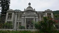 |
Tai Po DistrictTai Po DistrictTai Po District is one of the 18 districts of Hong Kong. It covers the areas of Tai Po, Tai Po Kau, Ting Kok, Plover Cove and the northern part of Sai Kung Peninsula on both shores of Tolo Channel. It is located in the New Territories...
| Name | Location | Notes/References | Photographs |
|---|---|---|---|
| Kwun Yum Temple | Ta Tit Yan | ||
| Pun Chun Yuen Tai Hung Po Dien | No. 17 Shek Lin Road, Kam Shan |  |
|
| Pun Chun Yuen Tak Wai Tong | No. 17 Shek Lin Road, Kam Shan | ||
| Pun Chun Yuen Glass House | No. 17 Shek Lin Road, Kam Shan | ||
| Tin Hau Temple Tin Hau temples in Hong Kong Over 70 temples are dedicated to Tin Hau in Hong Kong. They include:* Tin Hau temple, located at 10 Tin Hau Temple Road, Causeway Bay, east of Victoria Park, in Eastern District, on Hong Kong Island. It is a declared monument. The temple has given its name to the MTR station serving it .* The Tin... |
Sha Tau, Ping Chau Ping Chau Ping Chau is an island in Hong Kong. It is also known as Tung Ping Chau . Tung is prepended to the name so as to avoid possible confusion with Peng Chau, another island in Hong Kong with an identically pronounced name in the Cantonese language... (Tung Ping Chau) |
 |
|
| Tin Hau Temple Tin Hau temples in Hong Kong Over 70 temples are dedicated to Tin Hau in Hong Kong. They include:* Tin Hau temple, located at 10 Tin Hau Temple Road, Causeway Bay, east of Victoria Park, in Eastern District, on Hong Kong Island. It is a declared monument. The temple has given its name to the MTR station serving it .* The Tin... Complex Shui Yuet Kung |
Ha Wai, Tap Mun Chau | ||
Tsuen Wan DistrictTsuen Wan DistrictTsuen Wan District is one of the 18 districts of Hong Kong. It is located in the New Territories and is served by the Tsuen Wan Line of the MTR metro system. It had a population of 275,527 in 2001...
| Name | Location | Notes/References | Photographs |
|---|---|---|---|
| Chuk Lam Sim Yuen | Fu Yung Shan, Tsuen Wan Tsuen Wan Tsuen Wan is a bay in the Kowloon area of Hong Kong, opposite to Tsing Yi Island across Rambler Channel. The market town of Tsuen Wan emerged for the surrounding villages and fleets of fishing boats in the area. The town is around the present-day Tsuen Wan Station of the MTR... |
"Bamboo Forest Monastery", built between 1929 and 1932. | |
| Old House of the Former Hoi Pa Tsuen (Formerly Lot 956 of Hoi Pa Tsuen) | Jockey Club Tak Wah Park, Tak Wah Street | ||
| Po Kwong Yuen Monastery | Lo Wai Road | ||
| Tin Hau Temple Tin Hau temples in Hong Kong Over 70 temples are dedicated to Tin Hau in Hong Kong. They include:* Tin Hau temple, located at 10 Tin Hau Temple Road, Causeway Bay, east of Victoria Park, in Eastern District, on Hong Kong Island. It is a declared monument. The temple has given its name to the MTR station serving it .* The Tin... |
Nos. 56-58 Castle Peak Road Castle Peak Road Castle Peak Road is the longest road in Hong Kong. It runs from Tai Po Road in Sham Shui Po, Kowloon to the very north of the New Territories, serving south, west and north New Territories, being one of the most distant roads in early Hong Kong.-Name:... , Tsing Lung Tau Tsing Lung Tau Tsing Lung Tau is a small area in Tsuen Wan West, New Territories in Hong Kong.-Geographical information:It is located on the southwest coast of the New Territories in Hong Kong, between Tsuen Wan and Tuen Mun. There are two villages: Tsing Lung Tau Village and Yuen Tun Village, with many... |
 |
|
| Chan Yi Cheung Ancestral Hall | Jockey Club Tak Wah Park, Tak Wah Street |  |
|
| Tin Hau Temple Tin Hau temples in Hong Kong Over 70 temples are dedicated to Tin Hau in Hong Kong. They include:* Tin Hau temple, located at 10 Tin Hau Temple Road, Causeway Bay, east of Victoria Park, in Eastern District, on Hong Kong Island. It is a declared monument. The temple has given its name to the MTR station serving it .* The Tin... |
No. 38 Ma Wan Town, Ma Wan Ma Wan Ma Wan is an island of Hong Kong, located between Lantau Island and Tsing Yi Island, with an area of 0.97 km². Administratively, it is part of Tsuen Wan District.... |
 |
|
Tuen Mun DistrictTuen Mun DistrictTuen Mun District is one of the 18 administrative districts of Hong Kong. Its name was previously 'Tsing Shan' and it changed in the 1970s. It is the westernmost continental district of Hong Kong, located about 32 km from the Kowloon Peninsula, 7 km southwest of Yuen Long and 18 km...
| Name | Location | Notes/References | Photographs |
|---|---|---|---|
| Ching Leung Fat Yuen | Ching Yan Siu Chuk, 21.5 Milestone, Fu Tei | ||
| Ching Leung Fat Yuen Fat Din | 21.5 Milestone, Fu Tei | ||
| Lau Ancestral Hall | Tuk Mei Chung, Lung Kwu Tan Lung Kwu Tan Lung Kwu Tan is an area located in the western part of Tuen Mun District, Hong Kong.-Geography:The area is located at the southwest of Castle Peak and consists of Lung Kwu Tan and Lung Kwu Sheung Tan.-Features:... |
||
| No.3 San Shek Wan North Road, (Formerly name as No.17 Yeung Tsing Road) | No. 3 San Shek Wan North Road | ||
| Sam Shing Temple | Tuen Tsz Wai, Lam Tei Lam Tei Lam Tei is an area in the Tuen Mun District, New Territories, Hong Kong. The region lies at the north end of Tuen Mun city. It is highly rural, with Miu Fat Monastery being a landmark of the region. The Sherwood and Botania Villa are two residential estate in Lam Tei.-Transportation:Lam Tei is... |
||
| Sin Hing Tung | Tuen Fat Road | ||
| Tin Hau Temple Tin Hau temples in Hong Kong Over 70 temples are dedicated to Tin Hau in Hong Kong. They include:* Tin Hau temple, located at 10 Tin Hau Temple Road, Causeway Bay, east of Victoria Park, in Eastern District, on Hong Kong Island. It is a declared monument. The temple has given its name to the MTR station serving it .* The Tin... |
Tai Lam Kok | ||
Wan Chai DistrictWan Chai DistrictThe Wan Chai District is one of the 18 districts of Hong Kong, located in the north of Hong Kong island. It had a population of 167,146 in 2001. The district has the second most educated residents with the highest income, the second lowest population and the third oldest residents, and is also the...
| Name | Location | Notes/References | Photographs |
|---|---|---|---|
| No.64 Kennedy Road Kennedy Road, Hong Kong Kennedy Road is a road in the Mid-levels on the Hong Kong Island, Hong Kong. Starting from Garden Road in the west, it goes past St. Joseph's College, Hong Kong Visual Arts Centre, Hong Kong Park and Hopewell Centre and ends at the junction with Queen's Road East near Morrison Hill in Wan Chai.At... |
No.64 Kennedy Road, Wan Chai Wan Chai Wan Chai is a metropolitan area situated at the western part of the Wan Chai District on the northern shore of Hong Kong Island, in Hong Kong. Its other boundaries are Canal Road to the east, Arsenal Street to the west and Bowen Road to the south. The area north of Gloucester Road is often called... |
||
| Tung Wah Eastern Hospital Tung Wah Eastern Hospital Tung Wah Eastern Hospital is a hospital under the Tung Wah Group of Hospitals.Opened in 1929, the hospital is located in So Kon Po, Causeway Bay and became a public hospital in 1991.... |
No. 19 Eastern Hospital Road, Causeway Bay Causeway Bay Causeway Bay is a heavily built-up area of Hong Kong, People's Republic of China, located on the Hong Kong Island, and covering parts of Wan Chai and Eastern districts. The Chinese name is also romanized as Tung Lo Wan as in Tung Lo Wan Road... |
 |
|
| Wan Chai Market Wan Chai Market The Wan Chai Market was constructed in 1937. It is located at 264 Queen's Road East and Stone Nullah Lane in Wan Chai, Hong Kong Island. It is a Grade III Historic Building.... |
No. 264 Queen's Road East, Wan Chai |  |
|
| Wan Chai Police Station Wan Chai Police Station Wan Chai Police Station , also known as No. 2 Police Station or Eastern Police Station, is a building located at No. 123 Gloucester Road, Wan Chai, Hong Kong.-History:... |
No. 123 Gloucester Road Gloucester Road, Hong Kong Gloucester Road is a major road in Hong Kong. It is in the north of Wan Chai and East Point on Hong Kong Island. It connects to Harcourt Road at its western end and it ends east along west side of Victoria Park. It forms part of Hong Kong's Route 4 and connects to the Island Eastern Corridor via... , Wan Chai |
 |
|
| Sikh Temple Khalsa Diwan Sikh Temple Khalsa Diwan Sikh Temple is a gurdwara in the Wan Chai District of Hong Kong, on the junction of Queen's Road East and Stubbs Road, Hong Kong Island.-History:... |
No. 371 Queen's Road East, Wan Chai, at the junction with Stubbs Road Stubbs Road Stubbs Road connects Happy Valley and The Peak area on Hong Kong Island, Hong Kong, through an area near the Wong Nai Chung Gap. It goes through a residential area of luxurious high-rise tower blocks.... |
 |
|
| The Church of Christ in China Shing Kwong Church | No. 7 Eastern Hospital Road, Causeway Bay |  |
|
Wong Tai Sin DistrictWong Tai Sin DistrictWong Tai Sin District is one of the 18 districts of Hong Kong, and is the only landlocked district of the city. It is located in Kowloon and has a population of 444,630...
| Name | Location | Notes/References | Photographs |
|---|---|---|---|
| Former Royal Airforce Hangar | Tai Hom Village Tai Hom Village Tai Hom Village was the largest squatter village in Kowloon, Hong Kong. Its demolition was completed in 2001, with a few structures of historical value being preserved... , Diamond Hill Diamond Hill Diamond Hill is a hill in Kowloon, Hong Kong. The name also refers to the area on or adjacent to the hill. It is surrounded by Ngau Chi Wan, San Po Kong, Wong Tai Sin and Tsz Wan Shan. Its northeast is limited by the ridge. It is principally a residential district.-Etymology:Contrary to its name,... |
http://www.conservancy.org.hk/heritage/TaiHom/index_E.htm | |
| Stone House Stone House (Diamond Hill) The Stone House is the last structure remaining from the former Tai Hom squatter village. The building is located at No. 4 Tai Koon Yuen , Diamond Hill, in the Wong Tai Sin District of Kowloon, Hong Kong. In 2002, Hong Kong's Antiquities Advisory Board recognized Stone House as a Grade III... |
No. 4 Tai Koon Yuen, Tai Hom Village Tai Hom Village Tai Hom Village was the largest squatter village in Kowloon, Hong Kong. Its demolition was completed in 2001, with a few structures of historical value being preserved... , Diamond Hill Diamond Hill Diamond Hill is a hill in Kowloon, Hong Kong. The name also refers to the area on or adjacent to the hill. It is surrounded by Ngau Chi Wan, San Po Kong, Wong Tai Sin and Tsz Wan Shan. Its northeast is limited by the ridge. It is principally a residential district.-Etymology:Contrary to its name,... |
http://www.conservancy.org.hk/heritage/TaiHom/index_E.htm |  |
Yau Tsim Mong DistrictYau Tsim Mong DistrictYau Tsim Mong District is one of 18 districts of Hong Kong, located on western Kowloon peninsula. It is the core urban area of Kowloon. The district has the third highest population density of all districts...
| Name | Location | Notes/References | Photographs |
|---|---|---|---|
| Hung Shing Temple Hung Shing Temple Hung Shing Temples or Tai Wong Temples are temples dedicated to Hung Shing. Hung Shing temples have been widely built in southern China, especially Guangdong province and in Hong Kong.-Existing temples:... |
Fuk Tsun Street, Tai Kok Tsui Tai Kok Tsui Tai Kok Tsui is an area west of Mong Kok in Kowloon, Hong Kong. The mixed land use of industrial and residential is present in the old area. The Cosmopolitan Dock and oil depots were previously located there... |
http://www.ctc.org.hk/en/indirectcontrol/temple16.asp | |
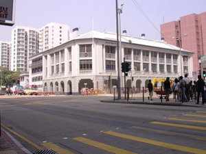
| Old Kowloon Police Headquarters | No. 142 Prince Edward Road West, Mong Kok Mong Kok Mong Kok , less often known as Argyle , is an area in the Yau Tsim Mong District on Kowloon Peninsula, Hong Kong... |
Now part of the Mong Kok Police Station |  |
| Some buildings within the Gun Club Hill | Gun Club Hill, Austin Road Austin Road Austin Road is a road in Kowloon, Hong Kong. It was named after John Gardiner Austin, Colonial Secretary of Hong Kong from 1868 to 1879.-Location:... , Tsim Sha Tsui Tsim Sha Tsui Tsim Sha Tsui , often abbreviated as TST, is an urbanized area in southern Kowloon, Hong Kong. The area is administratively part of the Yau Tsim Mong District. Tsim Sha Tsui East is a piece of land reclaimed from the Hung Hom Bay now east of Tsim Sha Tsui... |
Some buildings also Grade II |  |
| Whitfield Barracks Whitfield Barracks Whitfield Barracks were barracks in Tsim Sha Tsui, Kowloon, Hong Kong. The area is now the site of Kowloon Park, where several reconverted buildings remain.It was named after Henry Wase Whitfield, the commander of British Army in Hong Kong.-History:... , Block 58 |
Kowloon Park Kowloon Park Kowloon Park is a large public park in Tsim Sha Tsui, Kowloon Peninsula, Hong Kong. It is managed by the Leisure and Cultural Services Department.-History:... , Tsim Sha Tsui |
Located along Haiphong Road Haiphong Road Haiphong Road is a road south of Kowloon Park, Tsim Sha Tsui, Hong Kong. The road links Canton Road and Nathan Road. It was initially named as Elgin Street but its name changed to Haiphong, a city in Vietnam to avoid confusion with another Elgin Street on the Hong Kong Island-External links:*... , east of Kowloon Park Drive. Used as a godown of Hong Kong Museum of History Hong Kong Museum of History The Hong Kong Museum of History is a museum which preserves Hong Kong's historical and cultural heritage. It is located next to the Hong Kong Science Museum.... . |
 |
| Whitfield Barracks Whitfield Barracks Whitfield Barracks were barracks in Tsim Sha Tsui, Kowloon, Hong Kong. The area is now the site of Kowloon Park, where several reconverted buildings remain.It was named after Henry Wase Whitfield, the commander of British Army in Hong Kong.-History:... , Block S4 |
Kowloon Park Kowloon Park Kowloon Park is a large public park in Tsim Sha Tsui, Kowloon Peninsula, Hong Kong. It is managed by the Leisure and Cultural Services Department.-History:... , Tsim Sha Tsui |
Now houses the Health Education Exhibition and Resources Centre Health Education Exhibition and Resources Centre The Health Education Exhibition and Resources Centre was opened on 17 May 1997 in Hong Kong. It is under the management of Food and Environmental Hygiene Department in Government of Hong Kong.-History:... |
 |
| Whitfield Barracks Whitfield Barracks Whitfield Barracks were barracks in Tsim Sha Tsui, Kowloon, Hong Kong. The area is now the site of Kowloon Park, where several reconverted buildings remain.It was named after Henry Wase Whitfield, the commander of British Army in Hong Kong.-History:... , Blocks S61 & S62 |
Kowloon Park Kowloon Park Kowloon Park is a large public park in Tsim Sha Tsui, Kowloon Peninsula, Hong Kong. It is managed by the Leisure and Cultural Services Department.-History:... , Tsim Sha Tsui |
Blocks S61 and S62 now house the Hong Kong Heritage Discovery Centre Hong Kong Heritage Discovery Centre The Hong Kong Heritage Discovery Centre is located in the Kowloon Park, Haiphong Road, Tsim Sha Tsui, Kowloon, Hong Kong.The Centre occupies the historic Blocks S61 and S62 of the former Whitfield Barracks at the Kowloon Park.-History:... |
 |
| All Saints' Church | No. 2 Yim Po Fong Street, Mong Kok | ||
| Kowloon Union Church | No. 4 Jordan Road, Yau Ma Tei | 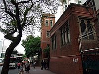 |
|
| Old Kowloon Fire Station, Main Block | No. 33 Salisbury Road Salisbury Road, Hong Kong Salisbury Road is a major road in Tsim Sha Tsui, Kowloon, Hong Kong. It runs parallel to Victoria Harbour, starting from its western end at the Star Ferry Pier, passing by Blackhead Point, to Tsim Sha Tsui East... , Tsim Sha Tsui |
 |
|
| Old Kowloon Fire Station, Accommodation Block | No. 33 Salisbury Road, Tsim Sha Tsui | ||
| Shui Yuet Temple | No. 90 Shan Tung Street, Mongkok | http://www.ctc.org.hk/en/indirectcontrol/temple15.asp Dedicated to Guan Yin |  |
| Yau Ma Tei Police Station Yau Ma Tei Police Station Yau Ma Tei Police Station is a police station in Yau Ma Tei, Kowloon, Hong Kong. Its buildings at No. 627 Canton Road, at the junction of Public Square Street, were erected in 1922 after relocation from the junction of Public Square Street and Shanghai Street.-History:Yau Ma Tei Police Station... |
No. 627 Canton Road Canton Road Canton Road is a road in Hong Kong, linking the former west reclamation shore in Tsim Sha Tsui, Jordan, Yau Ma Tei and Mong Kok on the Kowloon Peninsula. The road runs mostly parallel and west to Nathan Road. It starts from the junction with Salisbury Road in the south and ends in the north at the... , Yau Ma Tei Yau Ma Tei Yau Ma Tei, also known as Waterloo , is an area in the Yau Tsim Mong District in the south of the Kowloon Peninsula in Hong Kong.-Name:Yau Ma Tei is a phonetic transliteration of the name 油麻地 in Cantonese... |
 |
|
| Yau Ma Tei Wholesale Fruit Market | Shek Lung Street,Yau Ma Tei |  |
|
Yuen Long DistrictYuen Long DistrictYuen Long District , is one of the districts of Hong Kong located in the northwest of the New Territories. It had a population of 449,070 in 2001. The district has the youngest population of Hong Kong and the lowest income in the New Territories.-Geography:...
| Name | Location | Notes/References | Photographs |
|---|---|---|---|
| Chou Wong Yi Kung Study Hall | Shui Tau Tsuen Shui Tau Tsuen Shui Tau Tsuen is a village in Kam Tin area, Yuen Long District, New Territories, Hong Kong. The 17th century village is located 15 minutes' walk north of Kam Tin Road.-Historic buildings:... , Kam Tin Kam Tin Kam Tin , or Kam Tin Heung , is an area in the New Territories, Hong Kong. It is north of Tai Mo Shan and east of Yuen Long. It was formerly known as Sham Tin... |
http://www.go2yl.com/history.asp?id=k15&lang=eng |  |
| Lai Mansion | No. 485 Lai Uk Tsuen, Pat Heung Pat Heung Pat Heung is an area in the middle of New Territories, Hong Kong. Located at the east of Kam Tin and north of Shek Kong, it is the exit to Sheung Shui and Fanling... |
||
| Ming Tak Tong Ancestral Hall | Fan Tin Tsuen, San Tin San Tin San Tin , or San Tin Heung , is an area located near Lok Ma Chau area in the New Territories and belongs to the Yuen Long District, Hong Kong.... |
||
| So Lau Yuen | No. 25 Shui Tau, Pak Wai Tsuen, Kam Tin Kam Tin Kam Tin , or Kam Tin Heung , is an area in the New Territories, Hong Kong. It is north of Tai Mo Shan and east of Yuen Long. It was formerly known as Sham Tin... |
||
| Tang Lung Yau Wan Tsuen Um Ancestral Hall | No.57 Tsz Tong Tsuen, Kam Tin Kam Tin Kam Tin , or Kam Tin Heung , is an area in the New Territories, Hong Kong. It is north of Tai Mo Shan and east of Yuen Long. It was formerly known as Sham Tin... |
||
| Tin Hau Temple Tin Hau temples in Hong Kong Over 70 temples are dedicated to Tin Hau in Hong Kong. They include:* Tin Hau temple, located at 10 Tin Hau Temple Road, Causeway Bay, east of Victoria Park, in Eastern District, on Hong Kong Island. It is a declared monument. The temple has given its name to the MTR station serving it .* The Tin... |
No.62 Shui Mei Tsuen, Kam Tin Kam Tin Kam Tin , or Kam Tin Heung , is an area in the New Territories, Hong Kong. It is north of Tai Mo Shan and east of Yuen Long. It was formerly known as Sham Tin... |
||
| Tung Yik School | No. 199 Lin Fa Tei, Pat Heung Pat Heung Pat Heung is an area in the middle of New Territories, Hong Kong. Located at the east of Kam Tin and north of Shek Kong, it is the exit to Sheung Shui and Fanling... |
||
| Yau Sin Study Hall | San Wai, Ha Tsuen Ha Tsuen Ha Tsuen , or Ha Tsuen Heung is an area at the west of Yuen Long Town in Hong Kong. Administratively, it belongs to Yuen Long District.-History:... |
||
| Yeuk Hui Study Hall | Hang Mei Tsuen, Ping Shan Ping Shan Ping Shan is an area in the New Territories of Hong Kong. It is located west of Yuen Long Town and Shui Pin Wai, and south of Tin Shui Wai. Administratively, it is part of Yuen Long District.-Geography:... |
||
| Cheng Ancestral Hall | No. 120 Ngau Keng, Pat Heung Pat Heung Pat Heung is an area in the middle of New Territories, Hong Kong. Located at the east of Kam Tin and north of Shek Kong, it is the exit to Sheung Shui and Fanling... |
||
| Cheung Ancestral Hall | No.74 Shui Tsan Tin, Pat Heung Pat Heung Pat Heung is an area in the middle of New Territories, Hong Kong. Located at the east of Kam Tin and north of Shek Kong, it is the exit to Sheung Shui and Fanling... |
||
| Choi Kei Tung Ancestral Hall | Shek Wu Tong, Pat Heung Pat Heung Pat Heung is an area in the middle of New Territories, Hong Kong. Located at the east of Kam Tin and north of Shek Kong, it is the exit to Sheung Shui and Fanling... |
||
| Chung Shing Temple | No.136 Yuen Kong Tsuen, Pat Heung Pat Heung Pat Heung is an area in the middle of New Territories, Hong Kong. Located at the east of Kam Tin and north of Shek Kong, it is the exit to Sheung Shui and Fanling... |
||
| Kong Ha Wai | Near Kam Tsin Wai, Pat Heung Pat Heung Pat Heung is an area in the middle of New Territories, Hong Kong. Located at the east of Kam Tin and north of Shek Kong, it is the exit to Sheung Shui and Fanling... |
||
| Kwok Ancestral Hall | Lin Fa Tei, Pat Heung Pat Heung Pat Heung is an area in the middle of New Territories, Hong Kong. Located at the east of Kam Tin and north of Shek Kong, it is the exit to Sheung Shui and Fanling... |
||
| Lai Ancestral Hall | No. 146 Tsz Tong Tsuen, Sheung Tsuen, Pat Heung Pat Heung Pat Heung is an area in the middle of New Territories, Hong Kong. Located at the east of Kam Tin and north of Shek Kong, it is the exit to Sheung Shui and Fanling... |
||
| Lee Ancestral Hall | No.77 Shui Tsan Tin, Pat Heung Pat Heung Pat Heung is an area in the middle of New Territories, Hong Kong. Located at the east of Kam Tin and north of Shek Kong, it is the exit to Sheung Shui and Fanling... |
||
| Lee Ancestral Hall | No.63 Ngau Keng, Pat Heung Pat Heung Pat Heung is an area in the middle of New Territories, Hong Kong. Located at the east of Kam Tin and north of Shek Kong, it is the exit to Sheung Shui and Fanling... |
||
| Ling Wan Monastery | Kwun Yum Shan, Pat Heung Pat Heung Pat Heung is an area in the middle of New Territories, Hong Kong. Located at the east of Kam Tin and north of Shek Kong, it is the exit to Sheung Shui and Fanling... |
http://www.go2yl.com/history.asp?id=k07&lang=eng | |
| Lok Ma Chau Police Station | No. 100 Lok Ma Chau Road, Lok Ma Chau Lok Ma Chau Lok Ma Chau or Lokmachau is a village in Hong Kong's New Territories and also a major pedestrian and road border crossing point between Hong Kong and mainland China. It lies just south of the Sham Chun River , which forms the border between Hong Kong and mainland China... |
||
| Miu Kok Yuen | No. 136 Fung Kat Heung | ||
| Old Ping Shan Police Station | Ping Shan Ping Shan Ping Shan is an area in the New Territories of Hong Kong. It is located west of Yuen Long Town and Shui Pin Wai, and south of Tin Shui Wai. Administratively, it is part of Yuen Long District.-Geography:... |
http://www.amo.gov.hk/en/trails_pingshan1.php?tid=11 Now used as the Ping Shan Tang Clan Gallery cum Heritage Trail Visitors Centre. |  |
| Yeung Hau Temple | Sheung Cheung Wai, Ping Shan Ping Shan Ping Shan is an area in the New Territories of Hong Kong. It is located west of Yuen Long Town and Shui Pin Wai, and south of Tin Shui Wai. Administratively, it is part of Yuen Long District.-Geography:... |
http://www.amo.gov.hk/en/trails_pingshan1.php?tid=6 http://www.familles-franco-chinoises.com/hongkong/pingshan/pingshan.html#yeunghau http://www.familles-franco-chinoises.com/hongkong/pingshan/PingShan200908/dscn1170.html http://www.familles-franco-chinoises.com/hongkong/pingshan/PingShan20090913/picture036.html http://www.familles-franco-chinoises.com/hongkong/pingshan/PingShan200910/dscn1450pingshan20091024.html |  |
| Yeung Hau Temple | Tong Yan San Tsuen, Ping Shan Ping Shan Ping Shan is an area in the New Territories of Hong Kong. It is located west of Yuen Long Town and Shui Pin Wai, and south of Tin Shui Wai. Administratively, it is part of Yuen Long District.-Geography:... |
||
See also
- List of buildings and structures in Hong Kong
- Heritage conservation in Hong KongHeritage conservation in Hong KongThis article details the history and status of Heritage conservation in Hong Kong, as well as the role of various stakeholders.An indication of the size of the built heritage in Hong Kong is given by a territory-wide survey conducted by the Antiquities and Monuments Office between 1996 and 2000,...
- Declared monuments of Hong KongDeclared monuments of Hong KongDeclared monuments of Hong Kong are places, structures or buildings legally declared to be "protected". In Hong Kong, declaring a monument requires consulting the Antiquities Advisory Board, the approval of the Chief Executive as well as the publication of the notice in government gazette.As of 12...
- List of Grade I historic buildings in Hong Kong
- List of Grade II historic buildings in Hong Kong
- Heritage Trails in Hong KongHeritage Trails in Hong KongSeveral Heritage Trails have been designed in Hong Kong:Trails designed by the Antiquities and Monuments Office of the Leisure and Cultural Services Department:* Ping Shan Heritage Trail, in Yuen Long District, opened on 12 December 1993...
- History of Hong KongHistory of Hong KongHong Kong began as a coastal island geographically located off the southern coast of China. While pockets of settlements had taken place in the region with archaeological findings dating back thousands of years, regular written records were not made...
External links
- List of Graded Historic Buildings in Hong Kong (as at 6 November 2009), by the Antiquities and Monuments OfficeAntiquities and Monuments OfficeAntiquities and Monuments Office was established when the Antiquities and Monuments Ordinance was enacted in 1976, to preserve Hong Kong's monuments under appropriate protection....
, Hong Kong.