
Clear Water Bay Road
Encyclopedia
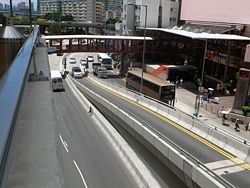
Clear Water Bay Road is a major road from a complex interchange in Ngau Chi Wan
to a dead end in Clear Water Bay
, Sai Kung
. It also is a route to Sai Kung Town
and Tseung Kwan O
via Hang Hau Road and Hiram's Highway
respectively. An expressway deviation, New Clear Water Bay Road (新清水灣道), bypasses a steep, winding, 1 in 6 alignment of Clear Water Bay Road near Shun Lee and Fei Ngo Shan.
 Clear Water Bay Road begins at Ngau Chi Wan at the junction with Lung Cheung Road
, Prince Edward Road East and Kwun Tong Road
near MTR
Choi Hung Station. It then is bypassed by the newer the deviation, running past Choi Wan Estate and Fei Ngo Shan south of Kowloon Peak
and reaches Cha Liu Au (茶寮凹). It then merges with the new road then continues as a four-lane expressway east to Tseng Lan Shue
, Pak Shek Wo and Pik Uk
and runs downhill to Tai Po Tsai
and The Hong Kong University of Science and Technology. There is an interchange to Sai Kung with the Hiram's Highway. It continues southward toward the Clear Water Bay Peninsula
and junctions Ying Yip Road and Hang Hau Road (to Tseung Kwan O) at a complex roundabout near Silverstrand. The road continues south-east to Sheung Sze Wan, and reaches Tai Au Mun. The road ends south in Tai Hang Tun (大坑墩).
In 1932, Clear Water Bay Road began from Kowloon City
. In 1963, part of the road was renamed Choi Hung Road and Prince Edward Road East.
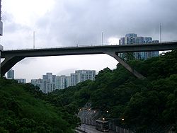
New Clear Water Bay Road is an expressway deviation of Clear Water Bay Road in Kowloon
near Choi Wan Estate and Shun Lee Estate. For the section below Kowloon Peak, Clear Water Road is very steep and reaches the ratio of 1 in 6 It is difficult for bus
es ascending the incline. With the ever increasing usage of the road due to population increases and the establishment of a country park
in Sai Kung, the Hong Kong Government decided to build a new expressway diverging from the junction near Choi Wan Estate, then junctions with Shun Lee Tsuen Road at Shun Lee, then loops back over itself to climb the steep hill and then rejoins the original road at the junction with Anderson Road
near Cha Liu Au. The new road was completed in 1980. The loop flyover runs from the hill north of Jordan Valley to Kowloon Peak, and it was the highest bridge in Hong Kong at that time.
Ngau Chi Wan
Ngau Chi Wan was a bay beneath Hammer Hill in New Kowloon, Hong Kong. Its geographical coordinates are 22° 20' 0" North, 114° 12' 0" East. It now refers to an area north of Choi Hung Estate....
to a dead end in Clear Water Bay
Clear Water Bay
Clear Water Bay is a bay on the east shore of Clear Water Bay Peninsula of Hong Kong located within Clear Water Bay Country Park. There are two beaches at Clear Water Bay, namely Clear Water Bay 1st beach and Clear Water Bay 2nd beach...
, Sai Kung
Sai Kung District
Sai Kung District is the second largest district in Hong Kong in terms of area. It comprises the southern half of Sai Kung Peninsula and Clear Water Bay Peninsula in the New Territories plus a strip to the east of Kowloon. The administrative centre is Sai Kung Town but the district's population is...
. It also is a route to Sai Kung Town
Sai Kung Town
Sai Kung Town or simply Sai Kung is a town on Sai Kung Peninsula, facing the Sai Kung Hoi , part of Sai Kung District in the New Territories, Hong Kong...
and Tseung Kwan O
Tseung Kwan O
Tseung Kwan O is a bay in Sai Kung District, New Territories, Hong Kong. In the northern tip of the bay lies the Tseung Kwan O Village....
via Hang Hau Road and Hiram's Highway
Hiram's Highway
Hiram's Highway is a road in Hong Kong. It connects the town of Sai Kung to the Clear Water Bay Road at Ta Ku Ling. It connects the Po Tung Road in the north....
respectively. An expressway deviation, New Clear Water Bay Road (新清水灣道), bypasses a steep, winding, 1 in 6 alignment of Clear Water Bay Road near Shun Lee and Fei Ngo Shan.
Clear Water Bay Road
Lung Cheung Road
Lung Cheung Road is part of Route 7 in Hong Kong, linking Kwun Tong Road at Ngau Chi Wan and Ching Cheung Road near Tai Wo Ping. It is a dual 3-lane carriageway for its entire length....
, Prince Edward Road East and Kwun Tong Road
Kwun Tong Road
Kwun Tong Road is a major road in Kwun Tong of New Kowloon in Hong Kong. It starts at the junction with Prince Edward Road East, Clear Water Bay Road and Lung Cheung Road in Ngau Chi Wan...
near MTR
MTR
Mass Transit Railway is the rapid transit railway system in Hong Kong. Originally opened in 1979, the system now includes 211.6 km of rail with 155 stations, including 86 railway stations and 69 light rail stops...
Choi Hung Station. It then is bypassed by the newer the deviation, running past Choi Wan Estate and Fei Ngo Shan south of Kowloon Peak
Kowloon Peak
Kowloon Peak or Fei Ngor Shan or Fei Ngo Shan is a tall mountain in the northeast corner of New Kowloon, Hong Kong, situated in Ma On Shan Country Park. It is crossed by both the Wilson Trail and the MacLehose Trail. On the lower slopes is Gilwell Campsite, belonging to The Scout...
and reaches Cha Liu Au (茶寮凹). It then merges with the new road then continues as a four-lane expressway east to Tseng Lan Shue
Tseng Lan Shue
Tseng Lan Shue is a small village in Sai Kung District, Kowloon, Hong Kong. It is located about 1 mile east of Fei Ngo Shan along the famous Clear Water Bay Road, and not far from Pik Uk. The village crosses Clear Water Bay Road and has about 250 settlements...
, Pak Shek Wo and Pik Uk
Pik Uk
Pik Uk is a small village in Sai Kung District, Kowloon, Hong Kong.-Location:Pik Uk is located on Clear Water Bay Road, roughly halfway between Ping Shek Estate and the Hang Hau Road roundabout, adjacent to Razor Hill, and not far from Tseng Lan Shue...
and runs downhill to Tai Po Tsai
Tai Po Tsai
Tai Po Tsai is an area and a village northeast of Tseung Kwan O New Town in Hong Kong. On the east mid slope of Razor Hill and facing Port Shelter, The village clusters in a small plain around Clear Water Bay Road in Sai Kung District. Pak Shui Wun is a beach off Tai Po Tsai is on the shore...
and The Hong Kong University of Science and Technology. There is an interchange to Sai Kung with the Hiram's Highway. It continues southward toward the Clear Water Bay Peninsula
Clear Water Bay Peninsula
Clear Water Bay Peninsula The Hong Kong University of Science and Technology , Clearwater Bay School , The Clearwater Bay Golf & Country Club and the Shaw Studio are located here...
and junctions Ying Yip Road and Hang Hau Road (to Tseung Kwan O) at a complex roundabout near Silverstrand. The road continues south-east to Sheung Sze Wan, and reaches Tai Au Mun. The road ends south in Tai Hang Tun (大坑墩).
In 1932, Clear Water Bay Road began from Kowloon City
Kowloon City
Kowloon City is an area in Kowloon, Hong Kong. It is named after the Kowloon Walled City, and is administratively part of Kowloon City District....
. In 1963, part of the road was renamed Choi Hung Road and Prince Edward Road East.
New Clear Water Bay Road
New Clear Water Bay Road is an expressway deviation of Clear Water Bay Road in Kowloon
Kowloon
Kowloon is an urban area in Hong Kong comprising the Kowloon Peninsula and New Kowloon. It is bordered by the Lei Yue Mun strait in the east, Mei Foo Sun Chuen and Stonecutter's Island in the west, Tate's Cairn and Lion Rock in the north, and Victoria Harbour in the south. It had a population of...
near Choi Wan Estate and Shun Lee Estate. For the section below Kowloon Peak, Clear Water Road is very steep and reaches the ratio of 1 in 6 It is difficult for bus
Bus
A bus is a road vehicle designed to carry passengers. Buses can have a capacity as high as 300 passengers. The most common type of bus is the single-decker bus, with larger loads carried by double-decker buses and articulated buses, and smaller loads carried by midibuses and minibuses; coaches are...
es ascending the incline. With the ever increasing usage of the road due to population increases and the establishment of a country park
Country park
A country park is an area designated for people to visit and enjoy recreation in a countryside environment.-History:In the United Kingdom the term 'Country Park' has a special meaning. There are over 400 Country Parks in England alone . Most Country Parks were designated in the 1970s, under the...
in Sai Kung, the Hong Kong Government decided to build a new expressway diverging from the junction near Choi Wan Estate, then junctions with Shun Lee Tsuen Road at Shun Lee, then loops back over itself to climb the steep hill and then rejoins the original road at the junction with Anderson Road
Anderson Road
Anderson Road is a road on the eastern border of the New Territories and New Kowloon in Hong Kong. It starts near the junction of Clear Water Bay Road and New Clear Water Bay Road, above Shun Lee Estate, and runs southeast windingly to Tsiu Lan Shue and continues eastward on the hills above Sau...
near Cha Liu Au. The new road was completed in 1980. The loop flyover runs from the hill north of Jordan Valley to Kowloon Peak, and it was the highest bridge in Hong Kong at that time.