
Sai Ying Pun
Encyclopedia
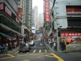
Sai Ying Pun is an area in Western District on the Hong Kong Island
in Hong Kong
. It is part of Central and Western District
in district administration.
In the Chinese language
, Sai (西) means "west" and Ying Pun (營盤) means "camp", especially military camp. It was where early British military stayed.
and Kennedy Town
are suburbs to the west, Sheung Wan
and Tai Ping Shan
are to the east, and Midlevels is higher on the hill to the south. The Victoria Harbour
is to the north. Sai Ying Pun is built on the steeply sloping lower slopes of Victoria Peak
and also on the western reclamation.
Period and is from the last phase of intrusions in the Hong Kong area. The granite is found over most of the north and centre of Hong Kong Island, and also Kowloon. The flat parts of Sai Ying Pun near the harbour are reclaimed land, built from landfill.
was the first road built in the area. It meandered around the camp structures and extended along the north coast of Hong Kong Island.
Sai Ying Pun was settled as Chinese immigrants moved into Hong Kong and built to the west of Tai Ping Shan. Europeans were assigned areas above High Street where Chinese were excluded from living.
In the early 1880s sewerage was installed into the area, with the main flow coming down Centre Street. Streets were macadamised or concreted at this time also.
Around 1882 Battery Road was renamed Bonham Road.
From 1884 to 1887 many brothels were declared by the Government to be unlicensed and closed down. These were mainly in First, Second and Third Street, but also in Sheung Fung Lane, Ui On Lane and Centre Street.
In 1894 an epidemic of bubonic plague
struck and afflicted Sai Ying Pun residents. It was not as bad initially as in neighbouring Tai Ping Shan
, which was resumed, abandoned and demolished to improve hygiene. However Sheung Fung Lane residents were almost wiped out. Government Reports called this area the number IX health district and went into great detail about the buildings where the disease occurred. In 1896 there were 115 cases, in 1898, 153 cases, in 1899, 263 cases, in 1900 98 cases, in 1904 there were 149 cases with 144 dying, and 55 cases in 1905. The great majority of infections in this district resulted in death.
In 1902, number 10 and 12 Second Street partially collapsed killing four people and injuring six. An additional storey had been added to number 10 at the beginning of 1901. It fell on number 12 and caused it to collapse as well. The extension had been designed by architects Denison and Ram. Also in 1902 a cookhouse at 56 First Street collapsed, one person was killed.
In 1899, there were 1017 houses and a population estimate of 24800. Most houses in Des Voeux Road and First Street were three stories, and in Second and Third Street they were two stories. In 1904 population was 24900 and average occupancy per floor of each house was 8.9. In 1905 the population was 25083.
In 1903, most houses were made from soft blue bricks, they had basements, and retaining walls at the front and back due to the steep slope.
In the early 1900s there was a Berlin Foundling House in High Street, a Sailors Home, and a Lunatic Asylum.


 Sai Ying Pun
is a proposed station on the Hong Kong MTR
Island line
serving the neighbourhood of Sai Ying Pun.
Trams run along Des Voeux Road West, taking passengers to the east or west of the Island.
Many bus routes run along Des Voeux Road and Queens Road West, with some routes routed through the lower parts of Water Street
and Pok Fu Lam Road. Most streets are too steep or narrow for buses, however the Green Mini Bus and some Red minibus routes travel through the upper streets.
Taxis frequent First Second and Third Streets.
A series of escalators can take pedestrians from First to Third Street via the markets.
The Western Harbour Tunnel goes from Sai Ying Pun under Victoria Harbour to West Kowloon and is a popular route for cars, trucks and buses.
Hong Kong Island
Hong Kong Island is an island in the southern part of the Hong Kong Special Administrative Region. It has a population of 1,289,500 and its population density is 16,390/km², as of 2008...
in Hong Kong
Hong Kong
Hong Kong is one of two Special Administrative Regions of the People's Republic of China , the other being Macau. A city-state situated on China's south coast and enclosed by the Pearl River Delta and South China Sea, it is renowned for its expansive skyline and deep natural harbour...
. It is part of Central and Western District
Central and Western District
The Central and Western District located on northern part of Hong Kong Island is one of the 18 administrative districts of Hong Kong. It had a population of 261,884 in 2001...
in district administration.
In the Chinese language
Chinese language
The Chinese language is a language or language family consisting of varieties which are mutually intelligible to varying degrees. Originally the indigenous languages spoken by the Han Chinese in China, it forms one of the branches of Sino-Tibetan family of languages...
, Sai (西) means "west" and Ying Pun (營盤) means "camp", especially military camp. It was where early British military stayed.
Location
Shek Tong TsuiShek Tong Tsui
Shek Tong Tsui is a town in Sai Wan on the north shore of Hong Kong Island in Hong Kong. Administratively, it belongs to the Central and Western District....
and Kennedy Town
Kennedy Town
Kennedy Town is at the western end of Sai Wan on Hong Kong Island in Hong Kong. It was named after Arthur Edward Kennedy, the 7th Governor of Hong Kong from 1872 to 1877...
are suburbs to the west, Sheung Wan
Sheung Wan
Sheung Wan is an area in Hong Kong, located in the north-west of Hong Kong Island, between Central and Sai Ying Pun. Administratively, it is part of the Central and Western District...
and Tai Ping Shan
Tai Ping Shan Street
Tai Ping Shan Street is a street marking the early colonial history in Hong Kong. Located at the north slope of Victoria Peak in Sheung Wan, the street starts east from a ladder street at the junction with Bridges Street and end west in Po Yan Street near Tung Wah Hospital...
are to the east, and Midlevels is higher on the hill to the south. The Victoria Harbour
Victoria Harbour
Victoria Harbour is a natural landform harbour situated between Hong Kong Island and the Kowloon Peninsula in Hong Kong. The harbour's deep, sheltered waters and strategic location on the South China Sea were instrumental in Hong Kong's establishment as a British colony and its subsequent...
is to the north. Sai Ying Pun is built on the steeply sloping lower slopes of Victoria Peak
Victoria Peak
Victoria Peak is a mountain in Hong Kong. It is also known as Mount Austin, and locally as The Peak. The mountain is located in the western half of Hong Kong Island...
and also on the western reclamation.
Geology
Sai Ying Pun is build on top of Hong Kong granite. The granite was formed in the Upper JurassicJurassic
The Jurassic is a geologic period and system that extends from about Mya to Mya, that is, from the end of the Triassic to the beginning of the Cretaceous. The Jurassic constitutes the middle period of the Mesozoic era, also known as the age of reptiles. The start of the period is marked by...
Period and is from the last phase of intrusions in the Hong Kong area. The granite is found over most of the north and centre of Hong Kong Island, and also Kowloon. The flat parts of Sai Ying Pun near the harbour are reclaimed land, built from landfill.
History
Queen's RoadQueen's Road
Queen's Road is the first road in Hong Kong built by the Government of Hong Kong between 1841 and 1843, spanning across Victoria City from Shek Tong Tsui to Wan Chai...
was the first road built in the area. It meandered around the camp structures and extended along the north coast of Hong Kong Island.
Sai Ying Pun was settled as Chinese immigrants moved into Hong Kong and built to the west of Tai Ping Shan. Europeans were assigned areas above High Street where Chinese were excluded from living.
In the early 1880s sewerage was installed into the area, with the main flow coming down Centre Street. Streets were macadamised or concreted at this time also.
Around 1882 Battery Road was renamed Bonham Road.
From 1884 to 1887 many brothels were declared by the Government to be unlicensed and closed down. These were mainly in First, Second and Third Street, but also in Sheung Fung Lane, Ui On Lane and Centre Street.
In 1894 an epidemic of bubonic plague
Bubonic plague
Plague is a deadly infectious disease that is caused by the enterobacteria Yersinia pestis, named after the French-Swiss bacteriologist Alexandre Yersin. Primarily carried by rodents and spread to humans via fleas, the disease is notorious throughout history, due to the unrivaled scale of death...
struck and afflicted Sai Ying Pun residents. It was not as bad initially as in neighbouring Tai Ping Shan
Tai Ping Shan Street
Tai Ping Shan Street is a street marking the early colonial history in Hong Kong. Located at the north slope of Victoria Peak in Sheung Wan, the street starts east from a ladder street at the junction with Bridges Street and end west in Po Yan Street near Tung Wah Hospital...
, which was resumed, abandoned and demolished to improve hygiene. However Sheung Fung Lane residents were almost wiped out. Government Reports called this area the number IX health district and went into great detail about the buildings where the disease occurred. In 1896 there were 115 cases, in 1898, 153 cases, in 1899, 263 cases, in 1900 98 cases, in 1904 there were 149 cases with 144 dying, and 55 cases in 1905. The great majority of infections in this district resulted in death.
In 1902, number 10 and 12 Second Street partially collapsed killing four people and injuring six. An additional storey had been added to number 10 at the beginning of 1901. It fell on number 12 and caused it to collapse as well. The extension had been designed by architects Denison and Ram. Also in 1902 a cookhouse at 56 First Street collapsed, one person was killed.
In 1899, there were 1017 houses and a population estimate of 24800. Most houses in Des Voeux Road and First Street were three stories, and in Second and Third Street they were two stories. In 1904 population was 24900 and average occupancy per floor of each house was 8.9. In 1905 the population was 25083.
In 1903, most houses were made from soft blue bricks, they had basements, and retaining walls at the front and back due to the steep slope.
In the early 1900s there was a Berlin Foundling House in High Street, a Sailors Home, and a Lunatic Asylum.
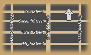
Main streets
- Bonham RoadBonham RoadBonham Road is a road in Sai Ying Pun, Hong Kong Island in Hong Kong. The road is a main road connecting Pokfulam Road in the west, near the University of Hong Kong, and Caine Road in the east, at the junction with Hospital Road and Seymour Road...
- Centre StreetCentre Street (Hong Kong)Centre Street is a street in the Sai Ying Pun suburb of Hong Kong. Centre Street is the key central point of the most active traditional market in Western District of Hong Kong Island...
- Connaught Road West
- Des Voeux RoadDes Voeux RoadDes Voeux Road Central and Des Voeux Road West are two roads on the north shore of Hong Kong Island, Hong Kong. They were named after the 10th Governor of Hong Kong, Sir George William Des Vœux...
West - Eastern StreetEastern StreetEastern Street is an early street of Hong Kong, located in the Sai Ying Pun area of Hong Kong Island. Eastern Street North is an extension of the street leading to the seafront following progressive harbour reclamations.-Eastern Street:...
- First StreetFirst Street (Hong Kong)First Street is a street in Sai Ying Pun suburb of Hong Kong.The street is part of planned streets in the early development. High Street, Third Street, Second Street and First Street run east to west horizontally on a slope while Centre Street, Western Street and Eastern Street run north to south...
- High Street, Hong KongHigh Street, Hong KongHigh Street is a one way street in Sai Ying Pun, Hong Kong, available only to minibuses and private vehicles. It connects Bonham Road in the east and Pok Fu Lam Road in the west. It runs from east to west from Western St to Pok Fu Lam Road, and from west to east from Western Street to Bonham Road...
- Pok Fu Lam RoadPok Fu Lam RoadPokfulam Road, or Pok Fu Lam Road, is a four-lane road in Hong Kong. Built on Hong Kong Island, the road runs between Sai Ying Pun and Wah Fu, through Pok Fu Lam....
- Queen's RoadQueen's RoadQueen's Road is the first road in Hong Kong built by the Government of Hong Kong between 1841 and 1843, spanning across Victoria City from Shek Tong Tsui to Wan Chai...
West - Second Street
- Third Street
- Western Street
- Whitty StreetWhitty StreetWhitty Street is a street in Shek Tong Tsui, Hong Kong Island, Hong Kong. Named after R.C. Whitty, the first manager of the Hong Kong and China Gas Company, the street is well-known as one of seven terminals of the Hong Kong Tramway...
Minor Lanes
There are many small lanes in Sai Ying Pun, mostly open only to pedestrians. They had more importance in historical times when they were used to access many houses. Now they are mainly cross connects and back alleys. Some lanes are private, and some may have disappeared. The interest nowadays is in their names, as very few places now have addresses in them.- Algar Lane
- Cheong On Lane
- Chung Ching Street
- David Lane
- Fuk Luk Lane
- Fuk On Lane
- Fuk Sau Lane
- Fuk Shing Lane
- Fuk Yu Lane
- Fuk Ching lane
- Heung Hing Lane
- Ki Ling Lane
- Kung Shu Lane
- Kwok Hing Lane
- Lau U Lane
- Leung I Fong
- On Wai Lane
- Praya West - renamed to Connaught Road when reclamation moved the harbour.
- Rienacker Street
- Sai Yuen Lane
- Sheung Fung Lane
- Sheung Hing Lane and Alley
- Tak Sing Lane
- Torsien Street
- Tuck Wa Lane
- Ui On Lane
- Un Fuk Lane
- Un Shing Lane
- Wai On Lane
- Water StreetWater Street, Hong KongWater Street is a street in Sai Ying Pun, Hong Kong. It runs from Connaught Road, crossing Des Voeux Road West and Queen's Road West then climbing steeply up the hill crossing Second Street, Third Street and then end in steps to High Street and Pok Fu Lam Road conjunction...
- Yu Lok Lane - contains the oldest existing houses in the suburb
Public facilities
- King George V Memorial Park, Hong KongKing George V Memorial Park, Hong KongKing George V Memorial Park, Hong Kong is an urban park in Sai Ying Pun and one of the few parks in Hong Kong bearing the former colonial links to the territory's past....
- Sun Yat Sen Memorial ParkSun Yat Sen Memorial ParkSun Yat Sen Memorial Park , originally named Western Park , is a waterfront park in the Sai Ying Pun area on Hong Kong Island and faces the Victoria Harbour. It is the only park in Hong Kong to be named for a Chinese historic figure.-See also:*Sun Yat Sen*Western Park Sports Centre*Zhongshan...
- Sai Ying Pun Community ComplexSai Ying Pun Community ComplexSai Ying Pun Community Complex is located at 2 High Street, Sai Ying Pun, Hong Kong. It is a 9-storey building built on the site of the Old Mental Hospital, of which only the granite facade and arched verandah were preserved.-History:...
- Sai Ying Pun Market
Schools
- Hong Kong University
- King's College, Hong KongKing's College, Hong KongKing’s College is a government secondary school in the western district of Hong Kong Island, and was founded in 1926. It is a boys-only college from Form one to five and admits female students in its matriculate classes...
- St. Paul's College, Hong KongSt. Paul's College, Hong KongSt. Paul's College is an Anglican day school for boys in Mid Levels, Hong Kong and is located adjacent to University of Hong Kong. Established in 1851, it is the oldest secondary school in Hong Kong that is still in operation...
- St. Stephen's Girls' CollegeSt. Stephen's Girls' CollegeSt Stephen's Girls' College , known as SSGC, which is one of the grant schools under Hong Kong Sheng Kung Hui , is a girls' schools in Hong Kong. Originally on Caine Road, the school moved to its current location at Lyttelton Road, Mid-Levels, in 1923. The main building is listed as one of the...
Transportation
Sai Ying Pun (MTR)
Sai Ying Pun is a proposed station on the Hong Kong MTR Island Line serving the neighbourhood of Sai Ying Pun in northwestern Hong Kong Island, Hong Kong....
is a proposed station on the Hong Kong MTR
MTR
Mass Transit Railway is the rapid transit railway system in Hong Kong. Originally opened in 1979, the system now includes 211.6 km of rail with 155 stations, including 86 railway stations and 69 light rail stops...
Island line
Island Line (MTR)
The Island Line is one of 10 lines of the MTR, the mass transit system in Hong Kong. It runs from Sheung Wan in the Central and Western District to Chai Wan in the Eastern District. The line first opened in 31 May 1985...
serving the neighbourhood of Sai Ying Pun.
Trams run along Des Voeux Road West, taking passengers to the east or west of the Island.
Many bus routes run along Des Voeux Road and Queens Road West, with some routes routed through the lower parts of Water Street
Water Street, Hong Kong
Water Street is a street in Sai Ying Pun, Hong Kong. It runs from Connaught Road, crossing Des Voeux Road West and Queen's Road West then climbing steeply up the hill crossing Second Street, Third Street and then end in steps to High Street and Pok Fu Lam Road conjunction...
and Pok Fu Lam Road. Most streets are too steep or narrow for buses, however the Green Mini Bus and some Red minibus routes travel through the upper streets.
Taxis frequent First Second and Third Streets.
A series of escalators can take pedestrians from First to Third Street via the markets.
The Western Harbour Tunnel goes from Sai Ying Pun under Victoria Harbour to West Kowloon and is a popular route for cars, trucks and buses.