
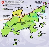
Lantau Island
Encyclopedia
Lantau Island based on the old local name of Lantau Peak , is the largest island
in Hong Kong
, located at the mouth of the Pearl River
. Administratively, most of Lantau Island is part of the Islands District of Hong Kong. A small northeastern portion of the island is located in the Tsuen Wan District
.
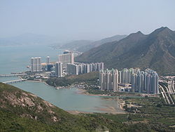
Originally the site of fishing villages, the island has been developed in recent years with the construction of Tung Chung
New Town on its north-western coast and the completion of several major infrastructure projects, including Lantau Link
(1997), Hong Kong International Airport
(1998), Hong Kong Disneyland
(2005) and Ngong Ping 360
(2006).
 With a land mass of 147.16 sqkm, it is the sixth largest island in China and the largest island in Hong Kong, almost twice the size of Hong Kong Island
.
Lantau Island primarily consists of mountainous terrain. Lantau Peak
(934 m) is the highest point of the island. It is the second highest in Hong Kong, after Tai Mo Shan
, and is almost twice the height of Victoria Peak
. Other mountains include Sunset Peak
(869 m), Lin Fa Shan
(766 m), Nei Lak Shan
(751 m) and Yi Tung Shan
(747 m).
Lantau Island is often referred to as "the lungs of Hong Kong", because of its abundance of indigenous forest and relative scarcity of high-rise residential developments which characterise Hong Kong Island
and Kowloon
. The largest country park of Hong Kong, Lantau South Country Park
is located on the island, which hosts two other parks, namely Lantau North Country Park
and its extension. These parks cover slightly more than half of the area of Lantau Island.
Shek Pik Reservoir
is the fourth largest freshwater reservoir in Hong Kong. Completed in 1963, it covers an area of 1.01 km² and has a capacity of 24.5 x 10⁶ m3.
Fan Lau Kok at the end of Fan Lau
Peninsula is the southwest end the territory of Hong Kong. The small island of Peaked Hill
, off Tsin Yue Wan (煎魚灣), marks the westernmost point on land of Hong Kong territories.
at Chek Lap Kok
in 1998 has led to economic development in north-western Lantau; the once quiet village of Tung Chung
became a New Town
and is now home to over 25,000 people located in 30 to 50 storey high-rise housing estates and condominiums located near the airport. Over the next few years, the population of the North Lantau New Town is expected to increase to a target population of over 200,000 across 7.6 km² of reclaimed land stretching from Tung Chung to Tai Ho.
Discovery Bay
is a privately owned residential development located on the south-eastern coast of Lantau. It has a current population of around 14,300 residents from over 30 different countries, giving it a reputation as an expatriate
enclave.
Other settlements include Mui Wo
, Tai O
, Tong Fuk
, Sha Lo Wan
villages, Pui O
villages, Luk Keng Village
, Nim Shue Wan Village
, San Shek Wan and The Sea Ranch
.
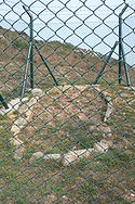 Early human artifacts have been discovered on the island. These artifacts include rock carvings at Shek Pik
which are thought to date back to the Bronze Age
, and a stone circle at Fan Lau
which is probably from the Neolithic
Age. Both sites are located on the southwestern coast of the island.
The island was also known as Tai Hai Shan (大奚山) before it became known as Lantau Island. It was often shown in navigation maps because of its proximity to a major sea route in South China
.
In 1276, the Southern Song Dynasty court fled to Guangdong
by boat to escape Mongol invaders, leaving the emperor Gong Di behind. The resistance centred on two young princes, Gong Di's brothers. The older boy Zhao Shi, was declared emperor at the age of nine. In 1277, the imperial court sought refuge first in Silvermine Bay (Mui Wo
) on Lantau Island and later in today's Kowloon City
. The older brother became ill, died, and was succeeded by the younger brother Zhao Bing at the age of seven. He died in 1279, and the Song Dynasty ended. These emperors are also believed to have held court in the Tung Chung
valley, which takes its name from a local hero who gave up his life for the emperor.
Lantau Island and Tuen Mun
were among the first European trading settlements in the Pearl River
area, established by Portuguese
traders in the 1510s. The Portuguese abandoned these settlements at around the year 1517, following defeat against Chinese troops. Later, the island became an important trading post for the British, long before they became interested in Hong Kong Island
.
Salt was illegally produced in Lantau island. This was discovered by the Chinese rulers during the 16th century, and the local warlord put many islanders to death as a result.
Like Cheung Chau
, Lantau was once the base for pirates and smugglers, and was one of the bases of Cheung Po Tsai
in the 19th century. Silver
was also mined at Mui Wo until the 19th century.
Lantau was a major site of resistance against the Japanese during the second world war. The resistance movement made use of the island's wooded areas and deep valleys in order to organise ambushes and move supplies. The resistance movement persevered through the war until the defeat of the Japanese occupation in 1945.
In 2000, Lantau Island was an important base for the Fiber-Optic Link Around the Globe
project and the Asia-Pacific Cable Network
which bridges the internet with the rest of the world.
 The Ngong Ping
Plateau features the Po Lin Monastery
and its vegetarian restaurant, as well as the 85 feet (25.9 m)-high bronze
Tian Tan Buddha
(or "Giant Buddha") statue, once the world's largest seated outdoor bronze Buddha statue. Walkers can ascend from Tung Chung to the monastery in two hours. Visitors can also take a 25 minute ride on a Ngong Ping 360
from Tung Chung to the Ngong Ping Plateau. Ngong Ping 360 is a tourism experience which combines a 5.7 km cable car journey with a cultural themed village and easy access to the Tian Tan Buddha Statue.
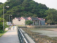
Tai O
is a fishing town located in the northwest of Lantau Island which is more than three centuries old. Tourists visit Tai O for its several hundred stilt houses, though many of those houses were damaged in a fire in July 2000. Tai O retains most of its historical setting such as waterways, stilt houses and fishing boats and it is famous for its fishing village scenery. Traditional Chinese food like salted fish and locally produced shrimp paste
can be found there.
Tung Chung Fort
was built in 1817 to thwart the opium
trade and defend the coast from pirates. There are 6 old cannons and the enclosures are made of granite
. During World War II
, the Japan
ese army occupied the fort. In 1979, it was listed as one of the historical monuments
of Hong Kong and was refurbished in 1988. The ruins of the Tung Chung Battery
, also a historical monument, are located nearby.
The Trappist Haven Monastery
at Tai Shui Hang, home to a number of Roman Catholic monks, sits on the east coast of Lantau Island, approximately halfway between the towns of Mui Wo and Discovery Bay. The Lantau Trappist
congregation was established in Beijing
in the 19th century.
Hong Kong Disneyland
lies on the northeastern part of the island, approximately two kilometres from Discovery Bay. It opened on 12 September 2005 on a massive land reclamation
project in Penny's Bay
. The US$1.8 billion project includes a Disney theme park, two hotels, and retail, dining and entertainment facilities stretching over 1.26 km² (310 acres). The project also has its own rail network linking from Sunny Bay MTR station
in Yam O
.
Over 50% of Lantau consists of national parks, including a large number of well-marked trails. The best known of these is the 70 kilometre, 12 section Lantau Trail
. The national parks feature campsites and youth hostels. Lantau's best-known and longest beach is Cheung Sha
and its most famous hike is to Sunset Peak
, the third highest elevation in Hong Kong.
s, often called pink dolphins, can be seen off the coast of Lantau. A marine park north of the island was designated to protect them.
s on Lantau Island: Chi Ma Wan
Correctional Institution, Chi Sun Correctional Institution (formerly the Chi Ma Wan Drug Addiction Treatment Centre), Ma Mo Ping Prison, Tong Fuk centre west of Tong Fuk
, Sha Tsui Detention Centre and the maximum security Shek Pik Prison, both located near Shek Pik reservoir. Plans were put forward by the government to build an enormous "Super Prison" on the sparsely populated nearby island of Hei Ling Chau
, to be connected by a bridge to Mui Wo
. However, this plan was indefinitely shelved after organised resistance by local residents.

(HKG/HKIA) is located on Chek Lap Kok
island and started service in July 1998. It is located off the north coast of Lantau, near the new town of Tung Chung
and is connected to urban areas by the Lantau Link
, which is composed of the Kap Shui Mun Bridge
, the Ma Wan Viaduct
, and the Tsing Ma Bridge
.
rail connection to the rest of Hong Kong via the MTR
's Airport Express
, along with several bus
routes. Using the Airport Express, the journey time between Central
, Hong Kong's business district, and Chep Lap Kok airport is 23 minutes. In addition, one can reach Tung Chung by train on the Tung Chung line of the MTR
, and there is a branch line to the Hong Kong Disneyland Resort
.
services provided by New World First Ferry
. This ferry service is available between Mui Wo and Central with a transportation time of about 30 to 50 minutes, depending on the vessel. A 24-hour ferry service operated by HKR International Limited connects Pier 3 in Central to Discovery Bay
with a transportation time of 25 minutes.
There are also several smaller inter-island ferry services linking neighbouring islands and the mainland. These ferries, known locally as kai-to
s provide scheduled services. These include Nim Shue Wan
(adjacent to Discovery Bay
, and Peng Chau
Island with a stopover at the Trappist Haven Monastery
on Lantau, Nim Shue Wan
and Mui Wo
on Lantau. Other Kai-To and ferry services link Peng Chau
, Mui Wo
Lantau, Chi Ma Wan
Lantau, and Cheung Chau
Island, and another links Tuen Mun
, Tung Chung
, Sha Lo Wan
, and Tai O
.
Travel between islands is also possible by walla walla
, a traditional water taxi
, typically from nearby Cheung Chau
Island.
provides major bus services within the island, where you can get to Tai O and Po Lin Monastery from Mui Wo pier.
In Hong Kong, there are three types of taxis
. Red taxis serve the urban areas, green taxis serve the New Territories
while taxis on Lantau Island are blue in colour. All three taxi services can ply for passengers at the Airport and Tung Chung, but only the blue taxis can take passengers to other locations on Lantau Island. There are 50 blue taxis serving the Lantau Island area.
, a gondola lift
, is located on Lantau and is operated by the MTR
. Opened in mid-September 2006, this provides a 5.7 km 20 minute gondola cableway journey between Tung Chung
and Ngong Ping
.
Island
An island or isle is any piece of sub-continental land that is surrounded by water. Very small islands such as emergent land features on atolls can be called islets, cays or keys. An island in a river or lake may be called an eyot , or holm...
in Hong Kong
Hong Kong
Hong Kong is one of two Special Administrative Regions of the People's Republic of China , the other being Macau. A city-state situated on China's south coast and enclosed by the Pearl River Delta and South China Sea, it is renowned for its expansive skyline and deep natural harbour...
, located at the mouth of the Pearl River
Pearl River (China)
The Pearl River or less commonly, the "Guangdong River" or "Canton River" etc., , is an extensive river system in southern China. The name Pearl River is usually used as a catchment term to refer to the watersheds of the Xi Jiang , the Bei Jiang , and the Dong Jiang...
. Administratively, most of Lantau Island is part of the Islands District of Hong Kong. A small northeastern portion of the island is located in the Tsuen Wan District
Tsuen Wan District
Tsuen Wan District is one of the 18 districts of Hong Kong. It is located in the New Territories and is served by the Tsuen Wan Line of the MTR metro system. It had a population of 275,527 in 2001...
.
Originally the site of fishing villages, the island has been developed in recent years with the construction of Tung Chung
Tung Chung
Tung Chung, meaning 'eastern stream', is an area situated on the north-western coast of Lantau Island in Hong Kong. Tung Chung, currently one of the latest generation of new towns, was formerly a rural village around Tung Chung Wan, and along the delta and lower courses of Tung Chung River and Ma...
New Town on its north-western coast and the completion of several major infrastructure projects, including Lantau Link
Lantau Link
The Lantau Link, formerly known as the Lantau Fixed Crossing, is a series of infrastructures linking Hong Kong International Airport to the urban areas in Hong Kong. It was officially opened on 27 April 1997, and it opened to traffic on 22 May the same year.-Infrastructure:The Lantau Link is 3.5 km...
(1997), Hong Kong International Airport
Hong Kong International Airport
Hong Kong International Airport is the main airport in Hong Kong. It is colloquially known as Chek Lap Kok Airport , being built on the island of Chek Lap Kok by land reclamation, and also to distinguish it from its predecessor, the closed Kai Tak Airport.The airport opened for commercial...
(1998), Hong Kong Disneyland
Hong Kong Disneyland
Hong Kong Disneyland is located on reclaimed land in Penny's Bay, Lantau Island. It is the first theme park located inside the Hong Kong Disneyland Resort and is owned and managed by the Hong Kong International Theme Parks. The park opened to visitors on 12 September 2005...
(2005) and Ngong Ping 360
Ngong Ping 360
The Ngong Ping 360 is a tourism project on Lantau Island in Hong Kong. The project was previously known as Tung Chung Cable Car Project before acquiring the Ngong Ping 360 brand in April 2005...
(2006).
Geography
Hong Kong Island
Hong Kong Island is an island in the southern part of the Hong Kong Special Administrative Region. It has a population of 1,289,500 and its population density is 16,390/km², as of 2008...
.
Lantau Island primarily consists of mountainous terrain. Lantau Peak
Lantau Peak
Lantau Peak or Fung Wong Shan is the second highest peak in Hong Kong. It is situated on Lantau Island, with a height of 934 m above sea level...
(934 m) is the highest point of the island. It is the second highest in Hong Kong, after Tai Mo Shan
Tai Mo Shan
Tai Mo Shan has the highest peak in Hong Kong, with an altitude of 957 m. It is located approximately at the geographical centre of the New Territories....
, and is almost twice the height of Victoria Peak
Victoria Peak
Victoria Peak is a mountain in Hong Kong. It is also known as Mount Austin, and locally as The Peak. The mountain is located in the western half of Hong Kong Island...
. Other mountains include Sunset Peak
Sunset Peak
Sunset Peak or Tai Tung Shan is the third highest peak in Hong Kong. It is situated on Lantau Island within Lantau South Country Park and Lantau North Country Park and stands at a height of 869 m above the sea level. The second highest Lantau Peak is on the western part of the island....
(869 m), Lin Fa Shan
Lin Fa Shan
Lin Fa Shan is the sixth highest hill in Hong Kong. With height of 766 m on the Lantau Island, it is situated between Mui Wo and Sunset Peak....
(766 m), Nei Lak Shan
Nei Lak Shan
Nei Lak Shan is the sixth highest hill in Hong Kong. With height on the Lantau Island, it is situated immediate north of Ngong Ping where Buddhist Po Lin Monastery located. Nei Lak, or correctly Mei Lak is a Cantonese language translation of Maitreya, the future Buddha, in Buddhism.There will...
(751 m) and Yi Tung Shan
Yi Tung Shan
Yi Tung Shan is the seventh highest hill in Hong Kong. With height 747 m on the Lantau Island, it is situated east of Sunset Peak. While the Sunset Peak, known as Tai Tung Shan, literally means the first east hill in Cantonese language, the Yi Tung Shan means the second east hill. The stage 2 of...
(747 m).
Lantau Island is often referred to as "the lungs of Hong Kong", because of its abundance of indigenous forest and relative scarcity of high-rise residential developments which characterise Hong Kong Island
Hong Kong Island
Hong Kong Island is an island in the southern part of the Hong Kong Special Administrative Region. It has a population of 1,289,500 and its population density is 16,390/km², as of 2008...
and Kowloon
Kowloon
Kowloon is an urban area in Hong Kong comprising the Kowloon Peninsula and New Kowloon. It is bordered by the Lei Yue Mun strait in the east, Mei Foo Sun Chuen and Stonecutter's Island in the west, Tate's Cairn and Lion Rock in the north, and Victoria Harbour in the south. It had a population of...
. The largest country park of Hong Kong, Lantau South Country Park
Lantau South Country Park
Lantau South Country Park is one of two rural parks on Lantau Island, the other one being Lantau North Country Park and its extension.Lantau South Country Park is located on the south side of the island. It was designated in 1978...
is located on the island, which hosts two other parks, namely Lantau North Country Park
Lantau North Country Park
Lantau North Country Park is one of two rural parks on Lantau Island and is located on the north side of the island. The 22 square kilometre park was designated in 1978.Highlights of the park include:* Wong Lung Hang Country Trail...
and its extension. These parks cover slightly more than half of the area of Lantau Island.
Shek Pik Reservoir
Shek Pik Reservoir
Shek Pik Reservoir is a reservoir in Shek Pik on Lantau Island in Hong Kong. Built between 1957 and 1963, it has a storage capacity of 24 million cubic metres and is the third largest reservoir in Hong Kong after High Island Reservoir and Plover Cove Reservoir.-Location:Shek Pik Reservoir is...
is the fourth largest freshwater reservoir in Hong Kong. Completed in 1963, it covers an area of 1.01 km² and has a capacity of 24.5 x 10⁶ m3.
Fan Lau Kok at the end of Fan Lau
Fan Lau
Fan Lau is peninsula and area in the southwest tip of Lantau Island in Hong Kong. It is also the southwest end the territory of Hong Kong. The very end of the tip is Fan Lau Kok . The peninsula separates water into Fan Lau Tung Wan in the east, and Fan Lau Sai Wan and Fan Lau Miu Wan Fan Lau...
Peninsula is the southwest end the territory of Hong Kong. The small island of Peaked Hill
Peaked Hill
Peaked Hill, also known as Kai Yek Kok , is a stack island on the westernmost point on land of Hong Kong territories. The island is close to the west side of southwest Lantau Island, near Tsin Yue Wan and can be spotted from the 7th stage of Lantau Trail.The island is north of Lantau Channel and...
, off Tsin Yue Wan (煎魚灣), marks the westernmost point on land of Hong Kong territories.
Population
Lantau Island has a relatively low population density, with a population of 45,000, compared to 1.4 million on Hong Kong Island. Settlements are scattered throughout the island and each has its own distinctive characteristic. The completion of the Hong Kong International AirportHong Kong International Airport
Hong Kong International Airport is the main airport in Hong Kong. It is colloquially known as Chek Lap Kok Airport , being built on the island of Chek Lap Kok by land reclamation, and also to distinguish it from its predecessor, the closed Kai Tak Airport.The airport opened for commercial...
at Chek Lap Kok
Chek Lap Kok
Chek Lap Kok was an island in the western waters of Hong Kong. Together with the smaller Lam Chau, it was leveled and merged via land reclamation into the platform for the current Hong Kong International Airport, which opened for commercial operations in 1998...
in 1998 has led to economic development in north-western Lantau; the once quiet village of Tung Chung
Tung Chung
Tung Chung, meaning 'eastern stream', is an area situated on the north-western coast of Lantau Island in Hong Kong. Tung Chung, currently one of the latest generation of new towns, was formerly a rural village around Tung Chung Wan, and along the delta and lower courses of Tung Chung River and Ma...
became a New Town
New Town
New Town may refer to:*New town, a generic name for a planned city development or expansion*In the United Kingdom, any of a specific set of towns created under various Acts of Parliament for population moved out of overcrowded conurbations-Places:...
and is now home to over 25,000 people located in 30 to 50 storey high-rise housing estates and condominiums located near the airport. Over the next few years, the population of the North Lantau New Town is expected to increase to a target population of over 200,000 across 7.6 km² of reclaimed land stretching from Tung Chung to Tai Ho.
Discovery Bay
Discovery Bay
Discovery Bay is a mixed, primarily residential, development comprising a residential development and private and public recreational facilities in Hong Kong. It is situated on the north-eastern coast of Lantau Island in the New Territories. The development spans an area of 650 hectares , and...
is a privately owned residential development located on the south-eastern coast of Lantau. It has a current population of around 14,300 residents from over 30 different countries, giving it a reputation as an expatriate
Expatriate
An expatriate is a person temporarily or permanently residing in a country and culture other than that of the person's upbringing...
enclave.
Other settlements include Mui Wo
Mui Wo
Mui Wo is a rural town on the eastern coast of Lantau Island in Hong Kong. The main beach in Mui Wo is known as Silver Mine Bay .-History:...
, Tai O
Tai O
Tai O is a fishing town, partly located on an island of the same name, on the western side of Lantau Island in Hong Kong.-Geography:On the main part of Lantau Island, a river splits to the north and west and at this fork lies the island referred to as Tai O. Two pedestrian bridges cross the river...
, Tong Fuk
Tong Fuk
Tong Fuk is a village and an area on Lantau Island in Hong Kong. It is a popular place for holiday recreation. Tong Fuk Beach in a bay south is a local attraction and visitors rent village houses for leisure.-Geography:...
, Sha Lo Wan
Sha Lo Wan
Sha Lo Wan is a bay in the northwest Lantau Island, Hong Kong. The bay faces north to Hong Kong International Airport. The area is occupied by indigenous inhabitants. There is no road access to area and thus their communication is on foot or by ferry. Because of its inconvenience to urban area,...
villages, Pui O
Pui O
Pui O , formerly Lo Pui O , is an area on Lantau Island in Hong Kong. It is a popular destination for holiday camping in Hong Kong. Visitors may also rent village houses for leisure. Located in the South Lantau, there are four main villages in Pui O, they are Lo Wai , San Wai , Lo Uk , and Ham Tin...
villages, Luk Keng Village
Luk Keng Village
Luk Keng Village or Luk Keng Tsuen is a village located at the peninsula of Yam O, Lantau Island, New Territories, Hong Kong, which links to Cheung Sok, a nearby uninhabited island, by a sandbank. There is a small pier with kai-to transportation service to Tsing Lung Tau, Tsuen Wan...
, Nim Shue Wan Village
Nim Shue Wan
Nim Shue Wan is the south facing bay on the south side of Discovery Bay, Lantau Island, Hong Kong. Nim Shue Wan village was a small fishing village but now has become a dormitory village for workers at nearby Discovery Bay.-Boats and piers:...
, San Shek Wan and The Sea Ranch
Chi Ma Wan
Chi Ma Wan is a bay on southeastern Lantau Island, New Territories, Hong Kong. Chi Ma Wan Peninsula is where Chi Ma Wan, as well as Cheung Sha Wan, Tai Long Wan, Yi Long Wan and Mong Tung Wan are located...
.
History
Shek Pik
Shek Pik is an area located along the southwestern coast of Lantau Island, Hong Kong. When the Shek Pik Reservoir was built, villages at Shek Pik were demolished and the villagers were relocated to other parts of Lantau Island and to Tsuen Wan...
which are thought to date back to the Bronze Age
Bronze Age
The Bronze Age is a period characterized by the use of copper and its alloy bronze as the chief hard materials in the manufacture of some implements and weapons. Chronologically, it stands between the Stone Age and Iron Age...
, and a stone circle at Fan Lau
Fan Lau
Fan Lau is peninsula and area in the southwest tip of Lantau Island in Hong Kong. It is also the southwest end the territory of Hong Kong. The very end of the tip is Fan Lau Kok . The peninsula separates water into Fan Lau Tung Wan in the east, and Fan Lau Sai Wan and Fan Lau Miu Wan Fan Lau...
which is probably from the Neolithic
Neolithic
The Neolithic Age, Era, or Period, or New Stone Age, was a period in the development of human technology, beginning about 9500 BC in some parts of the Middle East, and later in other parts of the world. It is traditionally considered as the last part of the Stone Age...
Age. Both sites are located on the southwestern coast of the island.
The island was also known as Tai Hai Shan (大奚山) before it became known as Lantau Island. It was often shown in navigation maps because of its proximity to a major sea route in South China
Northern and southern China
Northern China and southern China are two approximate regions within China. The exact boundary between these two regions has never been precisely defined...
.
In 1276, the Southern Song Dynasty court fled to Guangdong
Guangdong
Guangdong is a province on the South China Sea coast of the People's Republic of China. The province was previously often written with the alternative English name Kwangtung Province...
by boat to escape Mongol invaders, leaving the emperor Gong Di behind. The resistance centred on two young princes, Gong Di's brothers. The older boy Zhao Shi, was declared emperor at the age of nine. In 1277, the imperial court sought refuge first in Silvermine Bay (Mui Wo
Mui Wo
Mui Wo is a rural town on the eastern coast of Lantau Island in Hong Kong. The main beach in Mui Wo is known as Silver Mine Bay .-History:...
) on Lantau Island and later in today's Kowloon City
Kowloon City
Kowloon City is an area in Kowloon, Hong Kong. It is named after the Kowloon Walled City, and is administratively part of Kowloon City District....
. The older brother became ill, died, and was succeeded by the younger brother Zhao Bing at the age of seven. He died in 1279, and the Song Dynasty ended. These emperors are also believed to have held court in the Tung Chung
Tung Chung
Tung Chung, meaning 'eastern stream', is an area situated on the north-western coast of Lantau Island in Hong Kong. Tung Chung, currently one of the latest generation of new towns, was formerly a rural village around Tung Chung Wan, and along the delta and lower courses of Tung Chung River and Ma...
valley, which takes its name from a local hero who gave up his life for the emperor.
Lantau Island and Tuen Mun
Tuen Mun
Tuen Mun is a town near the mouth of Tuen Mun River and Castle Peak Bay in the New Territories, Hong Kong. It was one of the earliest settlements in Hong Kong which can be dated back to the Neolithic period. In the more recent past, it was home to many Tanka fishermen who gathered at the Castle...
were among the first European trading settlements in the Pearl River
Pearl River (China)
The Pearl River or less commonly, the "Guangdong River" or "Canton River" etc., , is an extensive river system in southern China. The name Pearl River is usually used as a catchment term to refer to the watersheds of the Xi Jiang , the Bei Jiang , and the Dong Jiang...
area, established by Portuguese
Portugal
Portugal , officially the Portuguese Republic is a country situated in southwestern Europe on the Iberian Peninsula. Portugal is the westernmost country of Europe, and is bordered by the Atlantic Ocean to the West and South and by Spain to the North and East. The Atlantic archipelagos of the...
traders in the 1510s. The Portuguese abandoned these settlements at around the year 1517, following defeat against Chinese troops. Later, the island became an important trading post for the British, long before they became interested in Hong Kong Island
Hong Kong Island
Hong Kong Island is an island in the southern part of the Hong Kong Special Administrative Region. It has a population of 1,289,500 and its population density is 16,390/km², as of 2008...
.
Salt was illegally produced in Lantau island. This was discovered by the Chinese rulers during the 16th century, and the local warlord put many islanders to death as a result.
Like Cheung Chau
Cheung Chau
Cheung Chau is a small island 10 km southwest of Hong Kong Island, is nicknamed as the 'dumbbell island' for its shape. It has been inhabited for longer than most other places in the territory of Hong Kong, with a population of about 23,000 up to 2006...
, Lantau was once the base for pirates and smugglers, and was one of the bases of Cheung Po Tsai
Cheung Po Tsai
Cheung Po Tsai was a 19th century Chinese pirate. He was also known as Cheung Po/Chang Pao/Zhang Bao .Several places in Hong Kong are linked to Cheung Po Tsai:* Cheung Po Tsai Cave, on Cheung Chau island...
in the 19th century. Silver
Silver
Silver is a metallic chemical element with the chemical symbol Ag and atomic number 47. A soft, white, lustrous transition metal, it has the highest electrical conductivity of any element and the highest thermal conductivity of any metal...
was also mined at Mui Wo until the 19th century.
Lantau was a major site of resistance against the Japanese during the second world war. The resistance movement made use of the island's wooded areas and deep valleys in order to organise ambushes and move supplies. The resistance movement persevered through the war until the defeat of the Japanese occupation in 1945.
In 2000, Lantau Island was an important base for the Fiber-Optic Link Around the Globe
Fiber-Optic Link Around the Globe
Fiber-Optic Link Around the Globe is a 28,000-kilometer-long submarine communications cable containing optical fiber that connects the United Kingdom, Japan, and many places in between. The cable is operated by India's Flag Telecom, a fully owned subsidiary of Reliance Communications. The system...
project and the Asia-Pacific Cable Network
APCN (cable system)
APCN or Asia-Pacific Cable Network is a submarine telecommunications cable system linking nine Asian countries.It has landing points in:*Petchaburi, Thailand*Mersing, Malaysia*Changi, Singapore*Ancol, Indonesia*Lantau, Hong Kong...
which bridges the internet with the rest of the world.
Tourist attractions
Ngong Ping
Ngong Ping is a highland in the western part of Lantau Island, Hong Kong. It hosts Po Lin Monastery and Tian Tan Buddha amidst the hills which is about 34 m tall. There are many hills nearby which are also an attraction to tourists. It is now the terminus of the cable car ride Ngong Ping Cable...
Plateau features the Po Lin Monastery
Po Lin Monastery
Po Lin Monastery is a Buddhist monastery, located on Ngong Ping Plateau, on Lantau Island, Hong Kong.The monastery was founded in 1906 by three monks visiting from Jiangsu and was initially known simply as "The Big Hut" . It was renamed to its present name in 1924...
and its vegetarian restaurant, as well as the 85 feet (25.9 m)-high bronze
Bronze
Bronze is a metal alloy consisting primarily of copper, usually with tin as the main additive. It is hard and brittle, and it was particularly significant in antiquity, so much so that the Bronze Age was named after the metal...
Tian Tan Buddha
Tian Tan Buddha
Tian Tan Buddha, also known as the Big Buddha, is a large bronze statue of a Buddha, completed in 1993, and located at Ngong Ping, Lantau Island, in Hong Kong. The statue is located near Po Lin Monastery and symbolises the harmonious relationship between man and nature, people and religion...
(or "Giant Buddha") statue, once the world's largest seated outdoor bronze Buddha statue. Walkers can ascend from Tung Chung to the monastery in two hours. Visitors can also take a 25 minute ride on a Ngong Ping 360
Ngong Ping 360
The Ngong Ping 360 is a tourism project on Lantau Island in Hong Kong. The project was previously known as Tung Chung Cable Car Project before acquiring the Ngong Ping 360 brand in April 2005...
from Tung Chung to the Ngong Ping Plateau. Ngong Ping 360 is a tourism experience which combines a 5.7 km cable car journey with a cultural themed village and easy access to the Tian Tan Buddha Statue.
Tai O
Tai O
Tai O is a fishing town, partly located on an island of the same name, on the western side of Lantau Island in Hong Kong.-Geography:On the main part of Lantau Island, a river splits to the north and west and at this fork lies the island referred to as Tai O. Two pedestrian bridges cross the river...
is a fishing town located in the northwest of Lantau Island which is more than three centuries old. Tourists visit Tai O for its several hundred stilt houses, though many of those houses were damaged in a fire in July 2000. Tai O retains most of its historical setting such as waterways, stilt houses and fishing boats and it is famous for its fishing village scenery. Traditional Chinese food like salted fish and locally produced shrimp paste
Shrimp paste
Shrimp paste or shrimp sauce, is a common ingredient used in Southeast Asian and Southern Chinese cuisine. It is known as terasi in Indonesian, ngapi in Burmese, kapi in Thai, Khmer and Lao language, belacan in Malay, mắm ruốc, mắm tép and mắm tôm in...
can be found there.
Tung Chung Fort
Tung Chung Fort
Tung Chung Fort is a fort located near Tung Chung, on Lantau Island, in Hong Kong. Located near Tung Chung Road, the fort is surrounded by villages of Sheung Ling Pei and Ha Ling Pei . It has a companion Tung Chung Battery on the coast.-History:...
was built in 1817 to thwart the opium
Opium
Opium is the dried latex obtained from the opium poppy . Opium contains up to 12% morphine, an alkaloid, which is frequently processed chemically to produce heroin for the illegal drug trade. The latex also includes codeine and non-narcotic alkaloids such as papaverine, thebaine and noscapine...
trade and defend the coast from pirates. There are 6 old cannons and the enclosures are made of granite
Granite
Granite is a common and widely occurring type of intrusive, felsic, igneous rock. Granite usually has a medium- to coarse-grained texture. Occasionally some individual crystals are larger than the groundmass, in which case the texture is known as porphyritic. A granitic rock with a porphyritic...
. During World War II
World War II
World War II, or the Second World War , was a global conflict lasting from 1939 to 1945, involving most of the world's nations—including all of the great powers—eventually forming two opposing military alliances: the Allies and the Axis...
, the Japan
Japan
Japan is an island nation in East Asia. Located in the Pacific Ocean, it lies to the east of the Sea of Japan, China, North Korea, South Korea and Russia, stretching from the Sea of Okhotsk in the north to the East China Sea and Taiwan in the south...
ese army occupied the fort. In 1979, it was listed as one of the historical monuments
Declared monuments of Hong Kong
Declared monuments of Hong Kong are places, structures or buildings legally declared to be "protected". In Hong Kong, declaring a monument requires consulting the Antiquities Advisory Board, the approval of the Chief Executive as well as the publication of the notice in government gazette.As of 12...
of Hong Kong and was refurbished in 1988. The ruins of the Tung Chung Battery
Tung Chung Battery
Tung Chung Battery is a former battery located in Tung Chung, Lantau Island, Hong Kong. It is close to Ma Wan Chung.Built in 1817, it is a companion of Tung Chung Fort of the south....
, also a historical monument, are located nearby.
The Trappist Haven Monastery
Trappist Haven Monastery
The Trappist Haven Monastery is a monastery at Tai Shui Hang , on Lantau Island, Hong Kong. It is home to a number of Roman Catholic monks of the Cistercian Order of the Strict Observance, or Trappists...
at Tai Shui Hang, home to a number of Roman Catholic monks, sits on the east coast of Lantau Island, approximately halfway between the towns of Mui Wo and Discovery Bay. The Lantau Trappist
Trappists
The Order of Cistercians of the Strict Observance , or Trappists, is a Roman Catholic religious order of cloistered contemplative monks who follow the Rule of St. Benedict...
congregation was established in Beijing
Beijing
Beijing , also known as Peking , is the capital of the People's Republic of China and one of the most populous cities in the world, with a population of 19,612,368 as of 2010. The city is the country's political, cultural, and educational center, and home to the headquarters for most of China's...
in the 19th century.
Hong Kong Disneyland
Hong Kong Disneyland
Hong Kong Disneyland is located on reclaimed land in Penny's Bay, Lantau Island. It is the first theme park located inside the Hong Kong Disneyland Resort and is owned and managed by the Hong Kong International Theme Parks. The park opened to visitors on 12 September 2005...
lies on the northeastern part of the island, approximately two kilometres from Discovery Bay. It opened on 12 September 2005 on a massive land reclamation
Land reclamation in Hong Kong
Land is in short supply in Hong Kong, and land reclamation has been conducted there since the mid-19th century.-Projects:One of the earliest and famous project was the Praya Reclamation Scheme, which added 50 to of land in 1890 during the second phase of construction...
project in Penny's Bay
Penny's Bay
Penny's Bay or Chok Ko Wan is a bay in north-eastern Lantau Island, and is the site of the Hong Kong Disneyland Resort, which consists of the Hong Kong Disneyland theme park, Disneyland Hotel, and Disney's Hollywood Hotel, and the Inspiration Lake. It is connected by a highway and a rail...
. The US$1.8 billion project includes a Disney theme park, two hotels, and retail, dining and entertainment facilities stretching over 1.26 km² (310 acres). The project also has its own rail network linking from Sunny Bay MTR station
Sunny Bay (MTR)
Sunny Bay is an MTR station in Yam O . It is between Tung Chung and Tsing Yi stations. The station is an interchange station between the Tung Chung Line and the Disneyland Resort Line to Hong Kong Disneyland. The station was originally to be named Yam O...
in Yam O
Yam O
Yam O is a bay located on the northeast shore of Lantau Island, in the New Territories of Hong Kong. It is part of the Tsuen Wan Rural West constituency of the Tsuen Wan District Council.Yam O was the one and only natural lumber preservation zone in Hong Kong...
.
Over 50% of Lantau consists of national parks, including a large number of well-marked trails. The best known of these is the 70 kilometre, 12 section Lantau Trail
Lantau Trail
The Lantau Trail , opened on 4 December, 1984, is a long-distance footpath on Lantau Island in the New Territories of Hong Kong. The 70 km trail is circular, starting and finishing in Mui Wo. The Lantau Trail has good visitor facilities along the way, and the route is well marked. There are...
. The national parks feature campsites and youth hostels. Lantau's best-known and longest beach is Cheung Sha
Beaches of Hong Kong
Hong Kong has a long coastline that is full of twists and turns with many bays and beaches. Many of them are well sheltered by mountains nearby, as Hong Kong is a mountainous place...
and its most famous hike is to Sunset Peak
Sunset Peak
Sunset Peak or Tai Tung Shan is the third highest peak in Hong Kong. It is situated on Lantau Island within Lantau South Country Park and Lantau North Country Park and stands at a height of 869 m above the sea level. The second highest Lantau Peak is on the western part of the island....
, the third highest elevation in Hong Kong.
Flora and fauna
Chinese white dolphinChinese White Dolphin
The Chinese white dolphin is a humpback dolphin species, one of eighty cetacean species. An adult is white or pink and may appear as an albino dolphin to some. Uniquely, the population along the Chinese coast has pink skin. Pink skin is not pigment, but blood vessels for thermoregulation...
s, often called pink dolphins, can be seen off the coast of Lantau. A marine park north of the island was designated to protect them.
Prisons
There are six prisonPrison
A prison is a place in which people are physically confined and, usually, deprived of a range of personal freedoms. Imprisonment or incarceration is a legal penalty that may be imposed by the state for the commission of a crime...
s on Lantau Island: Chi Ma Wan
Chi Ma Wan
Chi Ma Wan is a bay on southeastern Lantau Island, New Territories, Hong Kong. Chi Ma Wan Peninsula is where Chi Ma Wan, as well as Cheung Sha Wan, Tai Long Wan, Yi Long Wan and Mong Tung Wan are located...
Correctional Institution, Chi Sun Correctional Institution (formerly the Chi Ma Wan Drug Addiction Treatment Centre), Ma Mo Ping Prison, Tong Fuk centre west of Tong Fuk
Tong Fuk
Tong Fuk is a village and an area on Lantau Island in Hong Kong. It is a popular place for holiday recreation. Tong Fuk Beach in a bay south is a local attraction and visitors rent village houses for leisure.-Geography:...
, Sha Tsui Detention Centre and the maximum security Shek Pik Prison, both located near Shek Pik reservoir. Plans were put forward by the government to build an enormous "Super Prison" on the sparsely populated nearby island of Hei Ling Chau
Hei Ling Chau
Hei Ling Chau , formerly Hayling Chau, is an island of Hong Kong, located east of Silver Mine Bay and Chi Ma Wan of Lantau Island. It is administratively part of the Islands District.-Geography:...
, to be connected by a bridge to Mui Wo
Mui Wo
Mui Wo is a rural town on the eastern coast of Lantau Island in Hong Kong. The main beach in Mui Wo is known as Silver Mine Bay .-History:...
. However, this plan was indefinitely shelved after organised resistance by local residents.
Transport
Airport
Hong Kong International AirportHong Kong International Airport
Hong Kong International Airport is the main airport in Hong Kong. It is colloquially known as Chek Lap Kok Airport , being built on the island of Chek Lap Kok by land reclamation, and also to distinguish it from its predecessor, the closed Kai Tak Airport.The airport opened for commercial...
(HKG/HKIA) is located on Chek Lap Kok
Chek Lap Kok
Chek Lap Kok was an island in the western waters of Hong Kong. Together with the smaller Lam Chau, it was leveled and merged via land reclamation into the platform for the current Hong Kong International Airport, which opened for commercial operations in 1998...
island and started service in July 1998. It is located off the north coast of Lantau, near the new town of Tung Chung
Tung Chung
Tung Chung, meaning 'eastern stream', is an area situated on the north-western coast of Lantau Island in Hong Kong. Tung Chung, currently one of the latest generation of new towns, was formerly a rural village around Tung Chung Wan, and along the delta and lower courses of Tung Chung River and Ma...
and is connected to urban areas by the Lantau Link
Lantau Link
The Lantau Link, formerly known as the Lantau Fixed Crossing, is a series of infrastructures linking Hong Kong International Airport to the urban areas in Hong Kong. It was officially opened on 27 April 1997, and it opened to traffic on 22 May the same year.-Infrastructure:The Lantau Link is 3.5 km...
, which is composed of the Kap Shui Mun Bridge
Kap Shui Mun Bridge
The Kap Shui Mun Bridge in Hong Kong is one of the longest cable-stayed bridges in the world that transports both road and railway traffic, with the upper deck for motor vehicles, and the lower deck for both vehicles and the MTR. It has a main span of 430 metres and an overall length of 750 metres...
, the Ma Wan Viaduct
Ma Wan Viaduct
Ma Wan Viaduct is a viaduct built over Ma Wan, an island in the Hong Kong Special Administrative Region of the People's Republic of China. The viaduct connects the Tsing Ma Bridge and Kap Shui Mun Bridge, and is part of the Lantau Link and Route 8...
, and the Tsing Ma Bridge
Tsing Ma Bridge
The Tsing Ma Bridge is a bridge in Hong Kong. It is the world's seventh-longest span suspension bridge, and was the second longest at time of completion. The bridge was named after two of the islands at its ends, namely Tsing Yi and Ma Wan . It has two decks and carries both road and rail...
.
Rail
The airport also has a metroRapid transit
A rapid transit, underground, subway, elevated railway, metro or metropolitan railway system is an electric passenger railway in an urban area with a high capacity and frequency, and grade separation from other traffic. Rapid transit systems are typically located either in underground tunnels or on...
rail connection to the rest of Hong Kong via the MTR
MTR
Mass Transit Railway is the rapid transit railway system in Hong Kong. Originally opened in 1979, the system now includes 211.6 km of rail with 155 stations, including 86 railway stations and 69 light rail stops...
's Airport Express
Airport Express (MTR)
The Airport Express is one of the lines of the Mass Transit Railway serving Hong Kong. It links the principal urban areas of Hong Kong to Hong Kong International Airport and the associated AsiaWorld-Expo exhibition and convention centre....
, along with several bus
Bus
A bus is a road vehicle designed to carry passengers. Buses can have a capacity as high as 300 passengers. The most common type of bus is the single-decker bus, with larger loads carried by double-decker buses and articulated buses, and smaller loads carried by midibuses and minibuses; coaches are...
routes. Using the Airport Express, the journey time between Central
Central, Hong Kong
Central is the central business district of Hong Kong. It is located in Central and Western District, on the north shore of Hong Kong Island, across Victoria Harbour from Tsim Sha Tsui, the southernmost point of Kowloon Peninsula...
, Hong Kong's business district, and Chep Lap Kok airport is 23 minutes. In addition, one can reach Tung Chung by train on the Tung Chung line of the MTR
MTR
Mass Transit Railway is the rapid transit railway system in Hong Kong. Originally opened in 1979, the system now includes 211.6 km of rail with 155 stations, including 86 railway stations and 69 light rail stops...
, and there is a branch line to the Hong Kong Disneyland Resort
Hong Kong Disneyland Resort
The Hong Kong Disneyland Resort is a resort built by the Government of Hong Kong and The Walt Disney Company in Hong Kong on reclaimed land beside Penny's Bay, at the northeastern tip of Lantau Island, approximately two kilometres from Discovery Bay...
.
Water transport
Tourists can get to Lantau using ferryFerry
A ferry is a form of transportation, usually a boat, but sometimes a ship, used to carry primarily passengers, and sometimes vehicles and cargo as well, across a body of water. Most ferries operate on regular, frequent, return services...
services provided by New World First Ferry
New World First Ferry
New World First Ferry Services Limited is a ferry service company in Hong Kong. The company was established in November 1999, when it took over the 8 licensed ferry routes transferred from the Hongkong and Yaumati Ferry...
. This ferry service is available between Mui Wo and Central with a transportation time of about 30 to 50 minutes, depending on the vessel. A 24-hour ferry service operated by HKR International Limited connects Pier 3 in Central to Discovery Bay
Discovery Bay
Discovery Bay is a mixed, primarily residential, development comprising a residential development and private and public recreational facilities in Hong Kong. It is situated on the north-eastern coast of Lantau Island in the New Territories. The development spans an area of 650 hectares , and...
with a transportation time of 25 minutes.
There are also several smaller inter-island ferry services linking neighbouring islands and the mainland. These ferries, known locally as kai-to
Kai-to
The kai-to is a type of small, motorized ferry operating in Hong Kong. They are usually used to serve remote coastal settlements in the territory's outlying islands....
s provide scheduled services. These include Nim Shue Wan
Nim Shue Wan
Nim Shue Wan is the south facing bay on the south side of Discovery Bay, Lantau Island, Hong Kong. Nim Shue Wan village was a small fishing village but now has become a dormitory village for workers at nearby Discovery Bay.-Boats and piers:...
(adjacent to Discovery Bay
Discovery Bay
Discovery Bay is a mixed, primarily residential, development comprising a residential development and private and public recreational facilities in Hong Kong. It is situated on the north-eastern coast of Lantau Island in the New Territories. The development spans an area of 650 hectares , and...
, and Peng Chau
Peng Chau
Peng Chau is a small island located off the north-eastern coast of Lantau Island, Hong Kong, which has an area of 0.99 km².Peng Chau is known for its small island lifestyle, accessibility to fresh seafood, and several temples located around the island...
Island with a stopover at the Trappist Haven Monastery
Trappist Haven Monastery
The Trappist Haven Monastery is a monastery at Tai Shui Hang , on Lantau Island, Hong Kong. It is home to a number of Roman Catholic monks of the Cistercian Order of the Strict Observance, or Trappists...
on Lantau, Nim Shue Wan
Nim Shue Wan
Nim Shue Wan is the south facing bay on the south side of Discovery Bay, Lantau Island, Hong Kong. Nim Shue Wan village was a small fishing village but now has become a dormitory village for workers at nearby Discovery Bay.-Boats and piers:...
and Mui Wo
Mui Wo
Mui Wo is a rural town on the eastern coast of Lantau Island in Hong Kong. The main beach in Mui Wo is known as Silver Mine Bay .-History:...
on Lantau. Other Kai-To and ferry services link Peng Chau
Peng Chau
Peng Chau is a small island located off the north-eastern coast of Lantau Island, Hong Kong, which has an area of 0.99 km².Peng Chau is known for its small island lifestyle, accessibility to fresh seafood, and several temples located around the island...
, Mui Wo
Mui Wo
Mui Wo is a rural town on the eastern coast of Lantau Island in Hong Kong. The main beach in Mui Wo is known as Silver Mine Bay .-History:...
Lantau, Chi Ma Wan
Chi Ma Wan
Chi Ma Wan is a bay on southeastern Lantau Island, New Territories, Hong Kong. Chi Ma Wan Peninsula is where Chi Ma Wan, as well as Cheung Sha Wan, Tai Long Wan, Yi Long Wan and Mong Tung Wan are located...
Lantau, and Cheung Chau
Cheung Chau
Cheung Chau is a small island 10 km southwest of Hong Kong Island, is nicknamed as the 'dumbbell island' for its shape. It has been inhabited for longer than most other places in the territory of Hong Kong, with a population of about 23,000 up to 2006...
Island, and another links Tuen Mun
Tuen Mun
Tuen Mun is a town near the mouth of Tuen Mun River and Castle Peak Bay in the New Territories, Hong Kong. It was one of the earliest settlements in Hong Kong which can be dated back to the Neolithic period. In the more recent past, it was home to many Tanka fishermen who gathered at the Castle...
, Tung Chung
Tung Chung
Tung Chung, meaning 'eastern stream', is an area situated on the north-western coast of Lantau Island in Hong Kong. Tung Chung, currently one of the latest generation of new towns, was formerly a rural village around Tung Chung Wan, and along the delta and lower courses of Tung Chung River and Ma...
, Sha Lo Wan
Sha Lo Wan
Sha Lo Wan is a bay in the northwest Lantau Island, Hong Kong. The bay faces north to Hong Kong International Airport. The area is occupied by indigenous inhabitants. There is no road access to area and thus their communication is on foot or by ferry. Because of its inconvenience to urban area,...
, and Tai O
Tai O
Tai O is a fishing town, partly located on an island of the same name, on the western side of Lantau Island in Hong Kong.-Geography:On the main part of Lantau Island, a river splits to the north and west and at this fork lies the island referred to as Tai O. Two pedestrian bridges cross the river...
.
Travel between islands is also possible by walla walla
Walla-walla
Walla-walla , was a kind of motorboat serving in the Victoria Harbour of Hong Kong. It was the major means of transportation between Hong Kong Island and Kowloon before Star Ferry got the license to operate the cross-harbour ferry service...
, a traditional water taxi
Taxicab
A taxicab, also taxi or cab, is a type of vehicle for hire with a driver, used by a single passenger or small group of passengers, often for a non-shared ride. A taxicab conveys passengers between locations of their choice...
, typically from nearby Cheung Chau
Cheung Chau
Cheung Chau is a small island 10 km southwest of Hong Kong Island, is nicknamed as the 'dumbbell island' for its shape. It has been inhabited for longer than most other places in the territory of Hong Kong, with a population of about 23,000 up to 2006...
Island.
Road transport
Residents and tourists can travel within Lantau Island either by taxi or bus. The New Lantao BusNew Lantao Bus
The New Lantao Bus Company Limited – known as New Lantao Bus, or NLB – is a franchised bus company operating in Hong Kong.-History:...
provides major bus services within the island, where you can get to Tai O and Po Lin Monastery from Mui Wo pier.
In Hong Kong, there are three types of taxis
Taxicabs of Hong Kong
Taxicabs of Hong Kong provide a taxi system. Most taxis are independently owned and operated, but some are owned by taxi companies, and the drivers are employees....
. Red taxis serve the urban areas, green taxis serve the New Territories
New Territories
New Territories is one of the three main regions of Hong Kong, alongside Hong Kong Island and the Kowloon Peninsula. It makes up 86.2% of Hong Kong's territory. Historically, it is the region described in The Convention for the Extension of Hong Kong Territory...
while taxis on Lantau Island are blue in colour. All three taxi services can ply for passengers at the Airport and Tung Chung, but only the blue taxis can take passengers to other locations on Lantau Island. There are 50 blue taxis serving the Lantau Island area.
Cable car
The Ngong Ping 360Ngong Ping 360
The Ngong Ping 360 is a tourism project on Lantau Island in Hong Kong. The project was previously known as Tung Chung Cable Car Project before acquiring the Ngong Ping 360 brand in April 2005...
, a gondola lift
Gondola lift
A gondola lift is a type of aerial lift, normally called a cable car, which is supported and propelled by cables from above. It consists of a loop of steel cable that is strung between two stations, sometimes over intermediate supporting towers. The cable is driven by a bullwheel in a terminal,...
, is located on Lantau and is operated by the MTR
MTR
Mass Transit Railway is the rapid transit railway system in Hong Kong. Originally opened in 1979, the system now includes 211.6 km of rail with 155 stations, including 86 railway stations and 69 light rail stops...
. Opened in mid-September 2006, this provides a 5.7 km 20 minute gondola cableway journey between Tung Chung
Tung Chung
Tung Chung, meaning 'eastern stream', is an area situated on the north-western coast of Lantau Island in Hong Kong. Tung Chung, currently one of the latest generation of new towns, was formerly a rural village around Tung Chung Wan, and along the delta and lower courses of Tung Chung River and Ma...
and Ngong Ping
Ngong Ping
Ngong Ping is a highland in the western part of Lantau Island, Hong Kong. It hosts Po Lin Monastery and Tian Tan Buddha amidst the hills which is about 34 m tall. There are many hills nearby which are also an attraction to tourists. It is now the terminus of the cable car ride Ngong Ping Cable...
.
See also
- Geography of Hong KongGeography of Hong KongThe geography of Hong Kong primarily consists of three main territories: Hong Kong Island, Kowloon Peninsula, and the New Territories.The name "Hong Kong", literally meaning "fragrant harbour", is derived from the area around present-day Aberdeen on Hong Kong Island, where fragrant wood products...
- Beaches of Hong KongBeaches of Hong KongHong Kong has a long coastline that is full of twists and turns with many bays and beaches. Many of them are well sheltered by mountains nearby, as Hong Kong is a mountainous place...
- Hong Kong Country Parks & Special Areas
- Transportation in Hong Kong
- Tourism in Hong KongTourism in Hong KongThe tourism industry has been an important part of the economy of Hong Kong since it shifted to a service sector model in the late 1980s and early 90s...
- List of buildings, sites and areas in Hong Kong
- Route 8 (Hong Kong)Route 8 (Hong Kong)Route 8 of Hong Kong is an 3-lane carriageway dual 3-lane highway that links Lantau Island, Tsing Yi Island, Cheung Sha Wan in West Kowloon, and Sha Tin in the Northeast New Territories of Hong Kong. It is a combination of many sections....
External links
- Lantau Country Park
- First Ferry schedule
- New Lantao Bus
- Lantau - island of secrets and surprises Illustrated article.
- Living Islands Movement Ngo focused on sustainable development of Hong Kong islands, especially Lantau.
- Green Lantau Association Mission to protect, and educate people about, the natural environment of Lantau Island, Hong Kong.
- Ngong Ping 360
- Discover Hong Kong - tourism site