

Ping Chau
Encyclopedia
Island
An island or isle is any piece of sub-continental land that is surrounded by water. Very small islands such as emergent land features on atolls can be called islets, cays or keys. An island in a river or lake may be called an eyot , or holm...
in Hong Kong
Hong Kong
Hong Kong is one of two Special Administrative Regions of the People's Republic of China , the other being Macau. A city-state situated on China's south coast and enclosed by the Pearl River Delta and South China Sea, it is renowned for its expansive skyline and deep natural harbour...
. It is also known as Tung Ping Chau . Tung is prepended to the name so as to avoid possible confusion with Peng Chau
Peng Chau
Peng Chau is a small island located off the north-eastern coast of Lantau Island, Hong Kong, which has an area of 0.99 km².Peng Chau is known for its small island lifestyle, accessibility to fresh seafood, and several temples located around the island...
, another island in Hong Kong with an identically pronounced name in the Cantonese language. Administratively, the island is part of the Tai Po District
Tai Po District
Tai Po District is one of the 18 districts of Hong Kong. It covers the areas of Tai Po, Tai Po Kau, Ting Kok, Plover Cove and the northern part of Sai Kung Peninsula on both shores of Tolo Channel. It is located in the New Territories...
in the New Territories
New Territories
New Territories is one of the three main regions of Hong Kong, alongside Hong Kong Island and the Kowloon Peninsula. It makes up 86.2% of Hong Kong's territory. Historically, it is the region described in The Convention for the Extension of Hong Kong Territory...
.
Geography
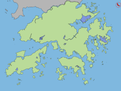
Geographically, Ping Chau is an offshore island located in the northeast corner of Hong Kong in Mirs BayMirs Bay
Mirs Bay is a bay in the northeast of Crooked Island and Sai Kung Peninsula of Hong Kong. Ping Chau stands in the midst of the bay...
and is close to the border with Guangdong Province
Guangdong
Guangdong is a province on the South China Sea coast of the People's Republic of China. The province was previously often written with the alternative English name Kwangtung Province...
in mainland China
Mainland China
Mainland China, the Chinese mainland or simply the mainland, is a geopolitical term that refers to the area under the jurisdiction of the People's Republic of China . According to the Taipei-based Mainland Affairs Council, the term excludes the PRC Special Administrative Regions of Hong Kong and...
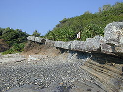
. The island has an area of 1.16 km² and consists of shale
Shale
Shale is a fine-grained, clastic sedimentary rock composed of mud that is a mix of flakes of clay minerals and tiny fragments of other minerals, especially quartz and calcite. The ratio of clay to other minerals is variable. Shale is characterized by breaks along thin laminae or parallel layering...
rock. The island is much closer to mainland China (4 km) than to the main landmass of Hong Kong. It is close to Nan'ao of Dapeng
Dapeng
Dapeng is a subdistrict in the south east of district Longgang, in prefecture-level city Shenzhen, in the Chinese province Guangdong. In this area the main spoken dialect are Dapeng dialect and Bao'an-Hakka....
. The island is the most easterly point of Hong Kong.
The island's largest village, Sha Tau, is something of a ghost town, with many cottages boarded up. A large part of the island is country parkland, with footpaths overgrown with orchids, wild mint, and morning glories
Morning glory
Morning glory is a common name for over 1,000 species of flowering plants in the family Convolvulaceae, whose current taxonomy and systematics is in flux...
. At the island's southeastern end are two huge rocks known as the Drum Rocks, or Watchman's Tower Rocks (更樓石, Kang Lau Shek). At the north end is a chunk of land that has broken away from the island; the Chinese say it represents the head of a dragon.
The island has the shape of a kidney bean with its concave side facing northeast. Its name "Ping Chau" means "flat island" in Chinese
Chinese language
The Chinese language is a language or language family consisting of varieties which are mutually intelligible to varying degrees. Originally the indigenous languages spoken by the Han Chinese in China, it forms one of the branches of Sino-Tibetan family of languages...
, suggesting that the island is flat. The highest points on the island are, in the south is 46 metres and the north is 37 metres. The eastern inner shore of the crescent hugs the Ping Chau Hoi with a few beaches
Beaches of Hong Kong
Hong Kong has a long coastline that is full of twists and turns with many bays and beaches. Many of them are well sheltered by mountains nearby, as Hong Kong is a mountainous place...
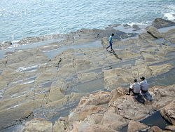
. On the contrary, the opposite western coast of the island is fairly rocky. This is the results of inclined siltstone
Siltstone
Siltstone is a sedimentary rock which has a grain size in the silt range, finer than sandstone and coarser than claystones.- Description :As its name implies, it is primarily composed of silt sized particles, defined as grains 1/16 - 1/256 mm or 4 to 8 on the Krumbein phi scale...
s, and wave action being higher along the west coast while the east is relatively sheltered.
History
Ping Chau is now deserted and has a checkered history. Guns and opium were once smuggled from here, and during the Cultural RevolutionCultural Revolution
The Great Proletarian Cultural Revolution, commonly known as the Cultural Revolution , was a socio-political movement that took place in the People's Republic of China from 1966 through 1976...
many mainlanders swam through shark-infested waters in hopes of reaching Ping Chau and the freedom of Hong Kong.
The island was once home to a thriving fishing and farm community of 3,000 people, but political turmoil during the Cultural Revolution cut off commerce with the mainland and most villagers moved away. In the 1950s, there were about 1,500 people living in the ten villages on the island. By the early 1970s, only a few elderly people remained on the island. In 2004, the last permanent resident moved out of Tung Ping Chau. Some may return on weekends.
Geology
Ping Chau is unique in the fact that it is the only sizable island in Hong Kong made up of sedimentary rock. Hong Kong is mostly formed of extrusive igneous rockIgneous rock
Igneous rock is one of the three main rock types, the others being sedimentary and metamorphic rock. Igneous rock is formed through the cooling and solidification of magma or lava...
s, after a series of major volcano
Volcano
2. Bedrock3. Conduit 4. Base5. Sill6. Dike7. Layers of ash emitted by the volcano8. Flank| 9. Layers of lava emitted by the volcano10. Throat11. Parasitic cone12. Lava flow13. Vent14. Crater15...
es erupted during the Jurassic Period. Following the volcanic activity, a basin formed in the northeast, with deposition in a brackish lake—producing the siltstones and chert of Tung Ping Chau, which have been dated from the early Tertiary
Tertiary
The Tertiary is a deprecated term for a geologic period 65 million to 2.6 million years ago. The Tertiary covered the time span between the superseded Secondary period and the Quaternary...
. It is also home to some spectacular cliffs and wave-cut platforms. Landforms such as these are very rarely found in the rest of Hong Kong
Tourism
The island has a temple dedicated Tin HauTin Hau temples in Hong Kong
Over 70 temples are dedicated to Tin Hau in Hong Kong. They include:* Tin Hau temple, located at 10 Tin Hau Temple Road, Causeway Bay, east of Victoria Park, in Eastern District, on Hong Kong Island. It is a declared monument. The temple has given its name to the MTR station serving it .* The Tin...
in the village of Sha Tau, and a Tam Kung
Tam Kung
Tam Kung or Tam Tai Sin is a sea deity worshiped in Hong Kong and Macau.In Chinese folk legends, Tam Kung was one of gods who could forecast the weather. He was born in Huizhou Prefecture. It was said that he could cure patients in his childhood. Tam Kung became an immortal in heaven at the age...
Temple. Many early residents of Ping Chau were from Shantou
Shantou
Shantou , historically known as Swatow or Suátao, is a prefecture-level city on the eastern coast of Guangdong province, People's Republic of China, with a total population of 5,391,028 as of 2010 and an administrative area of...
(Swatow) and they kept the tradition of worshiping Tam Kung after they settled on the island. There are many ancient buildings dating to 300 years ago that can also be found there.
On one side of the island there are steep cliffs, below which is an amazing wave-cut platform, with jagged rocks, set at a 30-degree angle, like a staircase. Here there are many rock pools containing all manner of marine life, such as sea urchin
Sea urchin
Sea urchins or urchins are small, spiny, globular animals which, with their close kin, such as sand dollars, constitute the class Echinoidea of the echinoderm phylum. They inhabit all oceans. Their shell, or "test", is round and spiny, typically from across. Common colors include black and dull...
s and crabs. On the island's coastline at the pier side, there are over 60 different species of coral
Coral
Corals are marine animals in class Anthozoa of phylum Cnidaria typically living in compact colonies of many identical individual "polyps". The group includes the important reef builders that inhabit tropical oceans and secrete calcium carbonate to form a hard skeleton.A coral "head" is a colony of...
, and 35 species of algae
Algae
Algae are a large and diverse group of simple, typically autotrophic organisms, ranging from unicellular to multicellular forms, such as the giant kelps that grow to 65 meters in length. They are photosynthetic like plants, and "simple" because their tissues are not organized into the many...
. In fact, some say that Ping Chau has the only diveable
Scuba diving
Scuba diving is a form of underwater diving in which a diver uses a scuba set to breathe underwater....
sites in Hong Kong.
For most, the island is reachable by ferry
Ferry
A ferry is a form of transportation, usually a boat, but sometimes a ship, used to carry primarily passengers, and sometimes vehicles and cargo as well, across a body of water. Most ferries operate on regular, frequent, return services...
from Ma Liu Shui
Ma Liu Shui
Ma Liu Shui or originally Ma Niu Shui is an area in Sha Tin District, in the New Territories, Hong Kong.The area faces Tide Cove and Tolo Harbour...
ferry pier, near the Chinese University of Hong Kong
Chinese University of Hong Kong
The Chinese University of Hong Kong is a research-led university in Hong Kong.CUHK is the only tertiary education institution in Hong Kong with Nobel Prize winners on its faculty, including Chen Ning Yang, James Mirrlees, Robert Alexander Mundell and Charles K. Kao...
. The landing point is the Tung Ping Chau Public Pier
Tung Ping Chau Public Pier
Tung Ping Chau Public Pier is a public pier in Tung Ping Chau, Tai Po, New Territories, Hong Kong. It is located at Wong Ye Kok near the centre of the island and it is the only pier on the island. Improvement works on the pier was completed in 2007. There is only one ferry route travelling...
, the only public pier on the island, located at Wong Ye Kok (王爺角). The ferry service is operated by Tsui Wah Ferry Services Co. Ltd on Saturdays, Sundays and public holidays only. The journey takes 1 hour 40 minutes.
During the weekends, there are many people on the island. These include those who have come to dive, and those who have come to see the cliffs and wave-cut platforms. Some people also use it as a weekend home. There is a camping site as well as picnic and barbecue sites on the island, managed by the Agriculture, Fisheries and Conservation Department
Agriculture, Fisheries and Conservation Department
The Agriculture, Fisheries and Conservation Department , formerly Agriculture and Fisheries Department before 2001, of the Hong Kong Government is responsible for agriculture and fisheries in Hong Kong, conservation projects and issues, and managing the country parks and special areas...
. 57,000 people visited Ping Chau in 2005.
Conservation
The Tin Hau Temple in the village of Sha Tau is listed as a Grade III Historic Building.Ping Chau has been designated as a Site of Special Scientific Interest
Site of Special Scientific Interest (Hong Kong)
Site of Special Scientific Interest or SSSI is a special area to protect wildlife, habitats and geographic features based on scientic interest in Hong Kong. Scientic interests are special features relating to animal life, plant life, geology and/or geography...
since 1978.
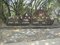
Ping Chau is part of the Plover Cove (Extension) Country Park, designated in 1979.
The Tung Ping Chau Marine Park was designated in 2001 as the fourth Marine Park in Hong Kong
Marine parks in Hong Kong
The Marine Parks Ordinance protects and conserves the marine environment and a rich collection of aquatic animals and plants, such as corals, sea grasses and dolphins. The ordinance also provides the legal framework for the designation, control and management of marine parks and marine reserves...
. It occupies a sea area of about 270 hectares which encloses the island of Ping Chau.
Ping Chau is one of the eight Geo-Areas of the Hong Kong National Geopark
Hong Kong National Geopark
Hong Kong Global Geopark of China , formerly Hong Kong National Geopark , was inaugurated on November 3, 2009. It covers an area of 50 km2 across parts of the Eastern and Northeastern New Territories. It includes eight sites...
, which was inaugurated on November 3, 2009.
See also
- Islands of Hong Kong
- Magic CopMagic CopMagic Cop aka. Kui moh ging chaat or Qu mo jing cha, Mr. Vampire 5 is a 1990 Hong Kong film produced by and starring Lam Ching-ying.-Plot:...
, a 1990 Hong Kong film partially set in Ping Chau
External links
- Tung Ping Chau, Hong Kong's wild eastern island
- Youngest sedimentary rock in Hong Kong - Tung Ping Chau
- Satellite image of Ping Chau by Google Maps
- Map of Ping Chau (.pdf document)
- Physical Geography of Ping Chau (.doc document)
- Ping Chau Country Trail
- Pictures of Ping Chau
- It's the perfect antidote to the stress of city life.