
Lake Sevan
Encyclopedia
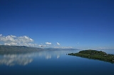
Lake Sevan is the largest lake in Armenia
and the Caucasus
region. It is one of the largest high-altitude lakes in the world.
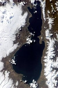
Lake Sevan is situated in the central part of the Republic of Armenia, inside the Gegharkunik Province, at the altitude of 1,900m above sea level. The total surface area of its basin is about 5,000 km2, the lake itself is 940 km2, and the volume is 34.0 bln cubic meters. It is fed by 28 rivers and streams. Only 10% of the outgoing water is drained by the Hrazdan
(Razdan) river, while the remaining 90% evaporates.
Before human intervention dramatically changed the Lake Sevan ecosystem, the lake was 95 metres deep, covered an area of 1,360 km² (5% of Armenia's entire area), had a volume of 58 km³ and a perimeter of 260 km. The lake surface was at an altitude of 1,950 m above sea level.
Along with Lake Van
and Lake Urmia
, Sevan was considered one of the three great lakes of the historical Armenian Kingdom, collectively referred to as the Seas of Armenia; it is the only one within the boundaries of today's Republic of Armenia. The Sevanavank
peninsula (formerly an island) is the historic area of the lake at its northern shores.
: Gökçe or Göyçə). On Russian map of 1902 the name of the lake is given as "Gokce or Sevanga". The name Sevan literally means "Black Van" referring to Lake Van
. It is said that long ago, Armenians came from the areas around Lake Van to Lake Sevan. They saw that the lake was dark and almost black yet reminded them of Van, therefore the lake was called Sevan. The Old Georgian name for the lake drew from the name of its old inhabitants (i.e. before the fall of Urartu), the Èrs
- it was called "Lake Ereta" by Leonti Mroveli in his Georgian Chronicles.
For a long time, the word "Sevan" was known to be connected with the monastery in the small island of the lake Sevan called "Sev Vank
" ("Black Monastery") built with black tuff. And this was known to be the etymology of name Sevan. But it was obviously wrong, because the word "Sevan" was older than the monastery itself.
Finally, the etymology of word "Sevan" was found in Teyseba
(the cuneiform inscription by Rusa I (730—714 B.C.)).
This inscription was a "birth certificate" of the term "Sevan". It was mentioned as "Suinia" or "Tsuinia".
Thus, the etymology of "Sevan" is similar to Yerevan
's etymology. It was named after simple geographical names, as water, river, lake, mount, etc.
Later scientists found that "Suinia" or "Tsuinia" means "lake" or "basin" in Urartian
.
 In 1910 Soukias Manasserian, one of the civil engineers behind the interventions that caused the Aral Sea
disaster, published a study Evaporating billions and stagnation of the Russian Capital, which suggested the lowering of the lake's surface to 45 metres and the use of the water for irrigation and hydroelectricity.
In Joseph Stalin
's era the plan was slightly modified: the water level would be reduced by 55 metres (5 metres more than suggested by Manasserian), the perimeter would shrink to 80 km and the volume to only 5 km³. Nut and oak trees would be planted on newly acquired land, and introducing some trout species into the remainder of the lake would increase fishery production tenfold.
The Armenian Supreme Soviet
approved the plan without consulting the local people, and major work started in 1933. The river bed of the Hrazdan was deepened, and construction of a tunnel 40 metres below the original water level was begun. The work was delayed due to World War II
and was only finished in 1949. The water level then began to fall by more than one metre per year.
As a result of these activities, the level of the lake fell by 19.01m, from its original of 1,915.9m. The lake is now 1,896.86 meters high; the volume has declined from 58.5 billion cubic meters to about 34.0, and the surface area has shrunk from 1,416.2 km2 to 1,238.1 km2.
 An ecological disaster like in the Aral Sea was avoided when the Stalinist era ended in 1956 and the project and its consequences were reviewed thoroughly. As there were difficulties with planting oaks and nut trees, and with fishery, the Sevan Committee was established with the mission "to raise the level as much as possible". Hydro-electric power stations on the Hrazdan would be replaced with thermal power stations. In 1962 the water level stabilized at 18 metres below the original level, but two years later the lake started to "bloom" due to eutrophic algae
.
In 1981, a 49 km tunnel was constructed, diverting water from the Arpa river (from a reservoir near Kechut
) to the lake near Artsvanist
. The water level in the lake rose only 1.5 metres, so another 22 km tunnel was begun from Vorotan River (further south from Kechut). Eighteen kilometers of this tunnel were completed before the collapse of the Soviet Union
, but in 1988 Azerbaijan
imposed an economic blockade on Armenia due to the Nagorno-Karabakh
conflict, and the work had to be stopped.
The Armenian government completed the Vorotan tunnel in 2003, but water has not yet begun to flow into the lake. The level stabilized at 20 metres below the original, and the lake's area is now 940 km².
Lowering of the water level had a variety of negative consequences. The biological mass of macrophyte plants fell, resulting in lack of adaptability of the plants changes, namely the weeding and pollution of the water in the newly emerged waterless area of the shore, as a result of growing erosion of this area. Dangerous reduction of Hypolimnion is another problem. Hypolimnion is the internal section of Sevan, in which the organic substances alochtone and autochtone mineralize. If this section is well developed (for example, in Lake Geneva
it is 85% of the whole mass) then mineralization process is active, without discarding the oxygen, dissolved in water.
Originally made from three churches, the monastery was built on an island. Receding waters in the mid-twentieth century created the current peninsula. The island was uninhabited until the end of the eighth century A.D., when monks built a chapel and a group of cells. The monastery was founded in 874 by King Ashot I, the first king of the Bagratid kingdom
, and his daughter Mariam. Two churches remain, St. Arakelots and Astvatsatsin. The island monastery was, according to historians of the time, used both for worship and pilgrimage, and as a place of exile for Armenian noblemen who had fallen into disgrace. It also was the residence and headquarters for Ashot I, from which he led a battle against invading Arabs beginning in 859.
During the battles monks and clergy fought alongside the army to defeat the Arabs, but repeated Arab and Ottoman
invasions continued. The monks on the island continuously led battles to protect the monastery, and such was the life in and around the monastery for almost 500 years until the Persians and the Ottomans
divided the Armenian kingdom. The monks in Gegham-kiunik specialized in medicine, and some of their natural cures are still used, based on herbs that grow in the wild around the lake. The monastery continued to function until the 20th century; the last monk left in 1930. Today the monastery is maintained by the Church
, which maintains a summer retreat for seminarians on the peninsula.
A less developed beach destination stretches along the eastern shore from Tsovagyugh
to Shorzha
, with numerous small cabins at Shorzha. The Avan Marak Tsapatagh Hotel, a Tufenkian Heritage Hotel, is a luxury resort on the undeveloped southeastern shore of the lake near Tsapatagh
.

 The most famous cultural monument is the Sevanavank
monastery near the town of Sevan at the northwestern shore. Initially the monastery was located on an island, but the fall of the water level turned it into a peninsula. Another monastery at the western shore is Hayravank Monastery
, and further south, in the village of Noraduz, there is a field of khachkar
s, a cemetery with approximately 900 khachkars
of different styles. Additional khachkars are found at Nerk'in Getashen
on the south coast. When the water level fell, many archaeological artifacts were found, 2000 years of age and older (some as old as the early Bronze Age). Most of them are now displayed in Yerevan
.
Sevan trout
(Salmo ischchan) was an endemic
species
of the lake, but it is endangered as some competitors were introduced into the lake, including common whitefish
(Coregonus lavaretus) from Lake Ladoga
, goldfish
(Carrasius auratus), and crayfish (Astacus leptodactylus
). If the Sevan trout is likely to become extinct in its "home" lake, it seems that it will survive in Issyk-Kul Lake (Kyrgyzstan
) where it was introduced in the 1970s.
Due to anthropogenic impact, changes have occurred in all the biologycal components of the lake, including bacteria, benthos
, and of course fish. Thus, the benthic mass increased 10-fold in 1940, due to oligochetes and chrinomices. Today, the former prevail and multiply the oxygen-rich residue at the bottom of the Lake.
The bojak and winter bakhtak species of the Sevan-endemic trout
have already disappeared. The summer bakhtak occurs rarely; the gegharkuni is still capable of reproducing naturally. In 1980s, the quantity of Sevan koghak significantly decreased. There are numerous reasons for this:
Other species
The lake is an important breeding ground for the Armenian Gull
(Larus armenicus) with about 4,000–5,000 pairs. Other birds which visit the lake include Bewick's swan
(Cygnus columbianus), lesser white-fronted goose
(Anser erythropus), red-crested pochard
(Netta rufina), ferruginous duck
(Aythya nyroca) and great black-headed gull
(Larus ichthyaetus). The mouflon are suffering a great population decline due to poaching and habitat loss. The Sevan trout, which made up thirty percent of the fish in Lake Sevan, have virtually disappeared. Another endangered visitor to the lake is the Armenian leopard
or panther (Panthera pardus tullianus).
Armenia
Armenia , officially the Republic of Armenia , is a landlocked mountainous country in the Caucasus region of Eurasia...
and the Caucasus
Caucasus
The Caucasus, also Caucas or Caucasia , is a geopolitical region at the border of Europe and Asia, and situated between the Black and the Caspian sea...
region. It is one of the largest high-altitude lakes in the world.
Lake Sevan is situated in the central part of the Republic of Armenia, inside the Gegharkunik Province, at the altitude of 1,900m above sea level. The total surface area of its basin is about 5,000 km2, the lake itself is 940 km2, and the volume is 34.0 bln cubic meters. It is fed by 28 rivers and streams. Only 10% of the outgoing water is drained by the Hrazdan
Hrazdan River
The Hrazdan is a major river of Armenia. It starts at the northwest extremity of Lake Sevan and flows south through the Kotayk marz and Armenia's capital, Yerevan. It then joins the Aras River along the border with Turkey. A Hydro-electric plant is located on the Hrazdan river...
(Razdan) river, while the remaining 90% evaporates.
Before human intervention dramatically changed the Lake Sevan ecosystem, the lake was 95 metres deep, covered an area of 1,360 km² (5% of Armenia's entire area), had a volume of 58 km³ and a perimeter of 260 km. The lake surface was at an altitude of 1,950 m above sea level.
Along with Lake Van
Lake Van
Lake Van is the largest lake in Turkey, located in the far east of the country in Van district. It is a saline and soda lake, receiving water from numerous small streams that descend from the surrounding mountains. Lake Van is one of the world's largest endorheic lakes . The original outlet from...
and Lake Urmia
Lake Urmia
Lake Urmia , ancient name: Lake Matiene) is a salt lake in northwestern Iran, near Iran's border with Turkey. The lake is between the Iranian provinces of East Azerbaijan and West Azerbaijan, west of the southern portion of the similarly shaped Caspian Sea...
, Sevan was considered one of the three great lakes of the historical Armenian Kingdom, collectively referred to as the Seas of Armenia; it is the only one within the boundaries of today's Republic of Armenia. The Sevanavank
Sevanavank
Sevanavank is a monastic complex located on a peninsula at the northwestern shore of Lake Sevan in the Gegharkunik Province of Armenia, not far from the town of Sevan. Initially the monastery was built at the southern shore of a small island...
peninsula (formerly an island) is the historic area of the lake at its northern shores.
Names
Historical names of the lake are Gegharkunik , Sea of Gegham ( Geghama tsov), Lychnitis (Greek and Latin), and (TurkicTurkic languages
The Turkic languages constitute a language family of at least thirty five languages, spoken by Turkic peoples across a vast area from Eastern Europe and the Mediterranean to Siberia and Western China, and are considered to be part of the proposed Altaic language family.Turkic languages are spoken...
: Gökçe or Göyçə). On Russian map of 1902 the name of the lake is given as "Gokce or Sevanga". The name Sevan literally means "Black Van" referring to Lake Van
Lake Van
Lake Van is the largest lake in Turkey, located in the far east of the country in Van district. It is a saline and soda lake, receiving water from numerous small streams that descend from the surrounding mountains. Lake Van is one of the world's largest endorheic lakes . The original outlet from...
. It is said that long ago, Armenians came from the areas around Lake Van to Lake Sevan. They saw that the lake was dark and almost black yet reminded them of Van, therefore the lake was called Sevan. The Old Georgian name for the lake drew from the name of its old inhabitants (i.e. before the fall of Urartu), the Èrs
Èrs
The Èr people, also known as Èrsh or the Hers, are a little-known ancient people inhabiting Northern modern Armenia, and to an extent, small areas of Northeast Turkey, Southern Georgia, and Northwest Azerbaijan...
- it was called "Lake Ereta" by Leonti Mroveli in his Georgian Chronicles.
For a long time, the word "Sevan" was known to be connected with the monastery in the small island of the lake Sevan called "Sev Vank
Sevanavank
Sevanavank is a monastic complex located on a peninsula at the northwestern shore of Lake Sevan in the Gegharkunik Province of Armenia, not far from the town of Sevan. Initially the monastery was built at the southern shore of a small island...
" ("Black Monastery") built with black tuff. And this was known to be the etymology of name Sevan. But it was obviously wrong, because the word "Sevan" was older than the monastery itself.
Finally, the etymology of word "Sevan" was found in Teyseba
Teyseba
Teyseba is located east of the town of Tsovinar and at the south-east corner of Lake Sevan in the Gegharkunik Province of Armenia. It is an important archaeological site because it was once a fortified city of the Urartian Kingdom founded by Rusa I between 735-713 BC, and is considered the best...
(the cuneiform inscription by Rusa I (730—714 B.C.)).
This inscription was a "birth certificate" of the term "Sevan". It was mentioned as "Suinia" or "Tsuinia".
Thus, the etymology of "Sevan" is similar to Yerevan
Yerevan
Yerevan is the capital and largest city of Armenia and one of the world's oldest continuously-inhabited cities. Situated along the Hrazdan River, Yerevan is the administrative, cultural, and industrial center of the country...
's etymology. It was named after simple geographical names, as water, river, lake, mount, etc.
Later scientists found that "Suinia" or "Tsuinia" means "lake" or "basin" in Urartian
Urartian language
Urartian, Vannic, and Chaldean are conventional names for the language spoken by the inhabitants of the ancient kingdom of Urartu that was located in the region of Lake Van, with its capital near the site of the modern town of Van, in the Armenian Highland, modern-day Eastern Anatolia region of...
.
Intervention
Aral Sea
The Aral Sea was a lake that lay between Kazakhstan in the north and Karakalpakstan, an autonomous region of Uzbekistan, in the south...
disaster, published a study Evaporating billions and stagnation of the Russian Capital, which suggested the lowering of the lake's surface to 45 metres and the use of the water for irrigation and hydroelectricity.
In Joseph Stalin
Joseph Stalin
Joseph Vissarionovich Stalin was the Premier of the Soviet Union from 6 May 1941 to 5 March 1953. He was among the Bolshevik revolutionaries who brought about the October Revolution and had held the position of first General Secretary of the Communist Party of the Soviet Union's Central Committee...
's era the plan was slightly modified: the water level would be reduced by 55 metres (5 metres more than suggested by Manasserian), the perimeter would shrink to 80 km and the volume to only 5 km³. Nut and oak trees would be planted on newly acquired land, and introducing some trout species into the remainder of the lake would increase fishery production tenfold.
The Armenian Supreme Soviet
Supreme Soviet
The Supreme Soviet of the Soviet Union was the Supreme Soviet in the Soviet Union and the only one with the power to pass constitutional amendments...
approved the plan without consulting the local people, and major work started in 1933. The river bed of the Hrazdan was deepened, and construction of a tunnel 40 metres below the original water level was begun. The work was delayed due to World War II
World War II
World War II, or the Second World War , was a global conflict lasting from 1939 to 1945, involving most of the world's nations—including all of the great powers—eventually forming two opposing military alliances: the Allies and the Axis...
and was only finished in 1949. The water level then began to fall by more than one metre per year.
As a result of these activities, the level of the lake fell by 19.01m, from its original of 1,915.9m. The lake is now 1,896.86 meters high; the volume has declined from 58.5 billion cubic meters to about 34.0, and the surface area has shrunk from 1,416.2 km2 to 1,238.1 km2.
Algae
Algae are a large and diverse group of simple, typically autotrophic organisms, ranging from unicellular to multicellular forms, such as the giant kelps that grow to 65 meters in length. They are photosynthetic like plants, and "simple" because their tissues are not organized into the many...
.
In 1981, a 49 km tunnel was constructed, diverting water from the Arpa river (from a reservoir near Kechut
Kechut
Kechut is a town in the Vayots Dzor Province of Armenia.- References :* – World-Gazetteer.com...
) to the lake near Artsvanist
Artsvanist
Artsvanist is a town in the Gegharkunik Province of Armenia. In the gorge south of the village is the early 10th century monastery of Vanevan and large but broken medieval khachkar monument nearby.- References :* – World-Gazetteer.com...
. The water level in the lake rose only 1.5 metres, so another 22 km tunnel was begun from Vorotan River (further south from Kechut). Eighteen kilometers of this tunnel were completed before the collapse of the Soviet Union
Soviet Union
The Soviet Union , officially the Union of Soviet Socialist Republics , was a constitutionally socialist state that existed in Eurasia between 1922 and 1991....
, but in 1988 Azerbaijan
Azerbaijan
Azerbaijan , officially the Republic of Azerbaijan is the largest country in the Caucasus region of Eurasia. Located at the crossroads of Western Asia and Eastern Europe, it is bounded by the Caspian Sea to the east, Russia to the north, Georgia to the northwest, Armenia to the west, and Iran to...
imposed an economic blockade on Armenia due to the Nagorno-Karabakh
Nagorno-Karabakh
Nagorno-Karabakh is a landlocked region in the South Caucasus, lying between Lower Karabakh and Zangezur and covering the southeastern range of the Lesser Caucasus mountains...
conflict, and the work had to be stopped.
The Armenian government completed the Vorotan tunnel in 2003, but water has not yet begun to flow into the lake. The level stabilized at 20 metres below the original, and the lake's area is now 940 km².
Negative effects
During the past decades, the ecological condition of Lake Sevan has undergone tangible changes and vast degradation due to the following reasons: a) reduced water level, b) increased eutrophication c) detrimental impact of human activity on the biological diversity of the lake.Lowering of the water level had a variety of negative consequences. The biological mass of macrophyte plants fell, resulting in lack of adaptability of the plants changes, namely the weeding and pollution of the water in the newly emerged waterless area of the shore, as a result of growing erosion of this area. Dangerous reduction of Hypolimnion is another problem. Hypolimnion is the internal section of Sevan, in which the organic substances alochtone and autochtone mineralize. If this section is well developed (for example, in Lake Geneva
Lake Geneva
Lake Geneva or Lake Léman is a lake in Switzerland and France. It is one of the largest lakes in Western Europe. 59.53 % of it comes under the jurisdiction of Switzerland , and 40.47 % under France...
it is 85% of the whole mass) then mineralization process is active, without discarding the oxygen, dissolved in water.
The Island Monastery
Originally made from three churches, the monastery was built on an island. Receding waters in the mid-twentieth century created the current peninsula. The island was uninhabited until the end of the eighth century A.D., when monks built a chapel and a group of cells. The monastery was founded in 874 by King Ashot I, the first king of the Bagratid kingdom
Bagratuni Kingdom of Armenia
The medieval Kingdom of Armenia, also known as Bagratid Armenia , was an independent state established by Ashot I Bagratuni in 885 following nearly two centuries of foreign domination of Greater Armenia under Arab Umayyad and Abbasid rule...
, and his daughter Mariam. Two churches remain, St. Arakelots and Astvatsatsin. The island monastery was, according to historians of the time, used both for worship and pilgrimage, and as a place of exile for Armenian noblemen who had fallen into disgrace. It also was the residence and headquarters for Ashot I, from which he led a battle against invading Arabs beginning in 859.
During the battles monks and clergy fought alongside the army to defeat the Arabs, but repeated Arab and Ottoman
Ottoman Empire
The Ottoman EmpireIt was usually referred to as the "Ottoman Empire", the "Turkish Empire", the "Ottoman Caliphate" or more commonly "Turkey" by its contemporaries...
invasions continued. The monks on the island continuously led battles to protect the monastery, and such was the life in and around the monastery for almost 500 years until the Persians and the Ottomans
Ottoman Empire
The Ottoman EmpireIt was usually referred to as the "Ottoman Empire", the "Turkish Empire", the "Ottoman Caliphate" or more commonly "Turkey" by its contemporaries...
divided the Armenian kingdom. The monks in Gegham-kiunik specialized in medicine, and some of their natural cures are still used, based on herbs that grow in the wild around the lake. The monastery continued to function until the 20th century; the last monk left in 1930. Today the monastery is maintained by the Church
Armenian Apostolic Church
The Armenian Apostolic Church is the world's oldest National Church, is part of Oriental Orthodoxy, and is one of the most ancient Christian communities. Armenia was the first country to adopt Christianity as its official religion in 301 AD, in establishing this church...
, which maintains a summer retreat for seminarians on the peninsula.
Beaches
There are numerous beaches along the entire lake shore. The most popular of them is a 2.5 kilometers stretch on the northern shore, extending northwest from the peninsula. Resorts include Harsnaqar Hotel, Best Western Bohemian Resort, and numerous smaller facilities. Activities include swimming, sunbathing, jet skiing, windsurfing, and sailing. The area also includes numerous campgrounds and picnic areas for daytime use.A less developed beach destination stretches along the eastern shore from Tsovagyugh
Tsovagyugh
Tsovagyugh formerly, Karatap and Chibukhly; is a town in the Gegharkunik province of Armenia.- References :* – World-Gazetteer.com...
to Shorzha
Shorzha
Shorzha is a village located along Lake Sevan northwest of the Artanish Peninsula in the Gegharkunik Province of Armenia. There is a 17th century chapel and cemetery on the south edge of the village. On the hill overlooking the village, there are the ruins of a chapel, and somewhere in the...
, with numerous small cabins at Shorzha. The Avan Marak Tsapatagh Hotel, a Tufenkian Heritage Hotel, is a luxury resort on the undeveloped southeastern shore of the lake near Tsapatagh
Tsapatagh
Tsapatagh is a town in the Gegharkunik Province of Armenia....
.
Sites of interest
Sevanavank
Sevanavank is a monastic complex located on a peninsula at the northwestern shore of Lake Sevan in the Gegharkunik Province of Armenia, not far from the town of Sevan. Initially the monastery was built at the southern shore of a small island...
monastery near the town of Sevan at the northwestern shore. Initially the monastery was located on an island, but the fall of the water level turned it into a peninsula. Another monastery at the western shore is Hayravank Monastery
Hayravank Monastery
Hayravank Monastery is a 9th-12th century Armenian monastery located just northeast of the village of Hayravank along the southwest shore of Lake Sevan in the Gegharkunik Province of Armenia. The monastic complex consists of a church, chapel, and gavit....
, and further south, in the village of Noraduz, there is a field of khachkar
Khachkar
A khachkar or khatchkar is a carved, cross-bearing, memorial stele covered with rosettes and other botanical motifs. Khachkars are characteristic of Medieval Christian Armenian art found in Armenia.-Description:...
s, a cemetery with approximately 900 khachkars
Noraduz cemetery
Noratus cemetery or Noraduz cemetery is a medieval cemetery with a large number of early khachkars located in the village of Noratus, Gegharkunik marz near Gavar and Lake Sevan, 90 km north of Yerevan. The cemetery has the largest cluster of khachkars in the republic of Armenia...
of different styles. Additional khachkars are found at Nerk'in Getashen
Nerk'in Getashen
Nerkin Getashen is a fishing village on the south coast of Lake Sevan in Gegharkunik, Armenia. In the early medieval it was the capital of the region known during that time as Kot....
on the south coast. When the water level fell, many archaeological artifacts were found, 2000 years of age and older (some as old as the early Bronze Age). Most of them are now displayed in Yerevan
Yerevan
Yerevan is the capital and largest city of Armenia and one of the world's oldest continuously-inhabited cities. Situated along the Hrazdan River, Yerevan is the administrative, cultural, and industrial center of the country...
.
Fauna
FishSevan trout
Sevan trout
The Sevan trout is an endemic fish species of Lake Sevan in Armenia. It is a salmonid fish related to the brown trout....
(Salmo ischchan) was an endemic
Endemic (ecology)
Endemism is the ecological state of being unique to a defined geographic location, such as an island, nation or other defined zone, or habitat type; organisms that are indigenous to a place are not endemic to it if they are also found elsewhere. For example, all species of lemur are endemic to the...
species
Species
In biology, a species is one of the basic units of biological classification and a taxonomic rank. A species is often defined as a group of organisms capable of interbreeding and producing fertile offspring. While in many cases this definition is adequate, more precise or differing measures are...
of the lake, but it is endangered as some competitors were introduced into the lake, including common whitefish
Common whitefish
Coregonus lavaretus is a species of freshwater whitefish, in the family Salmonidae. It is the type species of its genus Coregonus.There are widely different concepts about the number of species in the genus Coregonus and the delimitation of the species Coregonus lavaretus.-Lavaret:In a narrow...
(Coregonus lavaretus) from Lake Ladoga
Lake Ladoga
Lake Ladoga is a freshwater lake located in the Republic of Karelia and Leningrad Oblast in northwestern Russia, not far from Saint Petersburg. It is the largest lake in Europe, and the 14th largest lake by area in the world.-Geography:...
, goldfish
Goldfish
The goldfish is a freshwater fish in the family Cyprinidae of order Cypriniformes. It was one of the earliest fish to be domesticated, and is one of the most commonly kept aquarium fish....
(Carrasius auratus), and crayfish (Astacus leptodactylus
Astacus leptodactylus
Astacus leptodactylus, the Danube crayfish, Galician crayfish, Turkish crayfish or narrow-clawed crayfish is a species of crayfish imported and introduced to Central Europe in 19th century from the Caspian Sea region.-Description:...
). If the Sevan trout is likely to become extinct in its "home" lake, it seems that it will survive in Issyk-Kul Lake (Kyrgyzstan
Kyrgyzstan
Kyrgyzstan , officially the Kyrgyz Republic is one of the world's six independent Turkic states . Located in Central Asia, landlocked and mountainous, Kyrgyzstan is bordered by Kazakhstan to the north, Uzbekistan to the west, Tajikistan to the southwest and China to the east...
) where it was introduced in the 1970s.
Due to anthropogenic impact, changes have occurred in all the biologycal components of the lake, including bacteria, benthos
Benthos
Benthos is the community of organisms which live on, in, or near the seabed, also known as the benthic zone. This community lives in or near marine sedimentary environments, from tidal pools along the foreshore, out to the continental shelf, and then down to the abyssal depths.Many organisms...
, and of course fish. Thus, the benthic mass increased 10-fold in 1940, due to oligochetes and chrinomices. Today, the former prevail and multiply the oxygen-rich residue at the bottom of the Lake.
The bojak and winter bakhtak species of the Sevan-endemic trout
Trout
Trout is the name for a number of species of freshwater and saltwater fish belonging to the Salmoninae subfamily of the family Salmonidae. Salmon belong to the same family as trout. Most salmon species spend almost all their lives in salt water...
have already disappeared. The summer bakhtak occurs rarely; the gegharkuni is still capable of reproducing naturally. In 1980s, the quantity of Sevan koghak significantly decreased. There are numerous reasons for this:
- The level of the water lowered, the patches of rivers changed, the trout (gegharkuni and Aestivalis species) lost its natural spаwning place. Changes in the areas near the shore (mossing, disappearance of macrophyte plants) also had a negative impact on the trout lays. The trout spawns only in certain areas, where there is oxygen-rich underground water at the depth of 25–30 meters.
- Deoxidization of the bottom is extremely detrimental for salmonSalmonSalmon is the common name for several species of fish in the family Salmonidae. Several other fish in the same family are called trout; the difference is often said to be that salmon migrate and trout are resident, but this distinction does not strictly hold true...
, which are used to more than 4 mg O2 per liter. - In the last 10 years, poaching rapidly increased, which significantly reduced the amount of fish in the lake.
Other species
The lake is an important breeding ground for the Armenian Gull
Armenian Gull
The Armenian Gull is a large gull found in the Caucasus and Middle East. It was formerly classified as a subspecies of the Herring Gull but is now generally considered to be a separate species although BirdLife International lumps it with the Yellow-legged Gull The Armenian Gull (Larus armenicus)...
(Larus armenicus) with about 4,000–5,000 pairs. Other birds which visit the lake include Bewick's swan
Bewick's Swan
The Tundra Swan is a small Holarctic swan. The two taxa within it are usually regarded as conspecific, but are also sometimes split into two species, Cygnus bewickii of the Palaearctic and the Whistling Swan, C. columbianus proper, of the Nearctic...
(Cygnus columbianus), lesser white-fronted goose
Lesser White-fronted Goose
The Lesser White-fronted Goose is a goose closely related to the larger White-fronted Goose .It breeds in northernmost Asia, but it is a scarce breeder in Europe. There is a re-introduction scheme in Fennoscandia....
(Anser erythropus), red-crested pochard
Red-crested Pochard
The Red-crested Pochard is a large diving duck.Their breeding habitat is lowland marshes and lakes in southern Europe and southern and central Asia. They are somewhat migratory, and northern birds winter further south and into north Africa.The adult male is unmistakable. It has a rounded orange...
(Netta rufina), ferruginous duck
Ferruginous Duck
The Ferruginous Duck is a medium-sized diving duck from Eurasia. The species is known colloquially by birders as "Fudge Duck"....
(Aythya nyroca) and great black-headed gull
Great Black-headed Gull
The Pallas's Gull or Great Black-headed Gull, Ichthyaetus ichthyaetus, is a large gull. As is the case with many gulls, it has traditionally been placed in the genus Larus....
(Larus ichthyaetus). The mouflon are suffering a great population decline due to poaching and habitat loss. The Sevan trout, which made up thirty percent of the fish in Lake Sevan, have virtually disappeared. Another endangered visitor to the lake is the Armenian leopard
Persian Leopard
The Persian leopard , also called Caucasian leopard, is the largest leopard subspecies, and is native to eastern Turkey, the Caucasus mountains, northern Iran, southern Turkmenistan, and parts of western Afghanistan...
or panther (Panthera pardus tullianus).
Gallery
See also
- SevanavankSevanavankSevanavank is a monastic complex located on a peninsula at the northwestern shore of Lake Sevan in the Gegharkunik Province of Armenia, not far from the town of Sevan. Initially the monastery was built at the southern shore of a small island...
– Island monastery in lake sevan. - Sevan National ParkSevan National ParkSevan National Park in Armenia was established in 1978 to protect Lake Sevan and the surrounding areas. Sevan National Park falls under the jurisdiction of the Ministry of Nature Protection, and is managed as a research center, which monitors the ecosystems, and undertakes various conservation...
- Cleaning works continue in Sevan Lake shore
- www.sevan.am all about the lake
- Lake Sevan – Armeniapedia article with information and photos
- Rediscovering Armenia US Embassy;
- Tectonic impact on Lake Sevan environment
- Lake Sevan on worldlakes.org
- Photos at Armenia Photos.info
- National Assessment Report for the World Summit of Sustainable Development Johannesburg 2002
- Kamsar AvetisyanKamsar AvetisyanKamsar Avetisyan he has written articles regarding Armenological studies.In pedagogical institute of Abovyan's title. Kamsar Avetisyan has been working round with pedagogy for 30 years....
, ՀԱՅՐԵՆԱԳԻՏԱԿԱՆ ԷՏՅՈՒԴՆԵՐ – ՍԵՎԱՆԻ ԱՎԱԶԱՆ, "Sovetakan grogh", Yerevan, 1979