

Nagorno-Karabakh
Encyclopedia
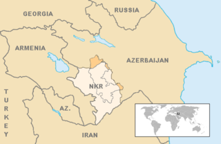
Nagorno-Karabakh is a landlocked
region in the South Caucasus
, lying between Lower Karabakh
and Zangezur and covering the southeastern range of the Lesser Caucasus
mountains. The region is mostly mountainous and forested and has an area of 4400 square kilometres (1,698.8 sq mi).
Most of the region is governed by the Nagorno-Karabakh Republic
, a de facto independent, but unrecognized
state established on the basis of the Nagorno-Karabakh Autonomous Oblast
within the Azerbaijan SSR
of the Soviet Union
. The territory is internationally recognized as part of Azerbaijan
, although it has not exercised power over most of the region since 1991. Since the end of the Nagorno-Karabakh War
in 1994, representatives of the governments of Armenia
and Azerbaijan have been holding peace talks mediated by the OSCE Minsk Group
on the region's disputed status.
The region is usually equated with the administrative borders of the former Nagorno-Karabakh Autonomous Oblast
within the Azerbaijani SSR comprising an area of 4400 square kilometres (1,698.8 sq mi). The historical area of the region, however, encompasses approximately 8223 square kilometres (3,174.9 sq mi).
attributive adjective, derived from the adjective nagorny (нагорный), which means "highland". The Azerbaijani
name of the region includes similar adjectives "dağlıq" (mountainous) or "yuxarı" (upper). Such words are not used in Armenian
name, but appeared in the official name of the region during the Soviet era as Nagorno-Karabakh Autonomous Oblast
. Other languages apply their own wording for mountainous, upper, or highland; for example, the official name used by the Nagorno-Karabakh Republic
in France is Haut-Karabakh, meaning "Upper Karabakh".
The word Karabakh
is generally held to originate from Turkic and Persian
, and literally means "black garden". The name first appears in Georgian
and Persian sources of the 13th and 14th centuries. Karabagh is an acceptable alternate spelling of Karabakh, and also denotes a kind of patterned rug
originally produced in the area.
In an alternative theory proposed by Bagrat Ulubabyan
the name Karabakh has a Turkic-Armenian origin, meaning "Greater Baghk" , a reference to Ktish-Baghk (later: Dizak
), one of the principalities of Artsakh under the rule of the Aranshahik dynasty, which held the throne of the Kingdom of Syunik in the 11th–13th centuries and called itself the "Kingdom of Baghk".
The names for the region in the various local languages all translate to "mountainous Karabakh", or "mountainous black garden":
, transliterated
Leṙnayin Ġarabaġ (mountainous Karabakh) or Yuxarı Qarabağ (upper Karabakh), transliterated Nagornyy Karabakh or Nagornyi Karabah
Nagorno-Karabakh is often referred to by the Armenians
living in the area as Artsakh
(Armenian: ), designating the 10th province of the ancient Kingdom of Armenia. In Urartian inscriptions (9th–7th centuries BC), the name Urtekhini is used for the region.
Ancient Greek
sources called the area Orkhistene.
 Nagorno-Karabakh falls within the lands occupied by peoples known to modern archaeologists as the Kura-Araxes culture
, who lived between the two rivers Kura
and Araxes.
The original population of the region consisted of various autochthonous
and migrant tribes. According to the American scholar Robert H. Hewsen
, these primordial tribes were "certainly not of Armenian origin", and "although certain Iranian peoples must have settled here during the long period of Persian and Median rule, most of the natives were not even Indo-Europeans".
However, relying on information provided by the 5th century Armenian historian Movses Khorenatsi
, other Western authors argued—and Hewsen himself indicated later—that these peoples could have been conquered by the Kingdom of Armenia
much earlier, in the 4th century BC.
Overall, from around 180 BC and up until the 4th century AD — before becoming part of the Armenian Kingdom again, in 855 — the territory of Nagorno-Karabakh remained part of the united Armenian Kingdom as the province of Artsakh
.
After the partition of Armenia between Byzantium
and Persia, in 387 AD, Artsakh
became part of Caucasian Albania
, which, in turn, came under strong Armenian religious and cultural influence. In the works of Movses Kaghankatvatsi
, Aran gets appointed to rule Aghvank
by Vagharshak, King of Armenia
. Armenians have lived in the Karabakh region since Roman
times: Strabo
states that, by the second or first century BC, the entire population of Greater Armenia—Artsakh
and Utik
included—spoke Armenian, though this does not mean that its population consisted exclusively of ethnic Armenians. Tigran the Great, King of Armenia, (ruled 95–55 BC), founded in Artsakh one of four cities named “Tigranakert” after himself. The ruins of the ancient Tigranakert, located 30 miles north-east of Stepanakert
, are being studied by a group of international scholars.
By the early Middle Ages
, the non-Armenian elements of Caucasian Albanian population of upper Karabakh had completed their merger into the Armenian population, and forever disappeared as identifiable groups. Armenian culture and civilization flourished in the early medieval Nagorno Karabakh— in Artsakh
and Utik
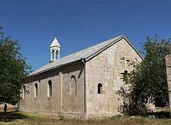
. In the 5th century, the first-ever Armenian school was opened on the territory of modern Nagorno-Karabakh—at the Amaras Monastery
—by the efforts of St. Mesrob Mashtots, the inventor of the Armenian Alphabet
. St. Mesrob was very active in preaching Gospel in Artsakh
and Utik
. Four chapters of Movses Kaghankatvatsi
’s “History...” amply describe St. Mesrob’s mission, referring to him as “enlightener,” “evangelizer” and “saint”. Overall, Mesrob Mashtots made three trips to Artsakh
and Utik
, ultimately reaching pagan territories at the foothills of the Greater Caucasus
.
It was at that time when the foremost Armenian historian Movses Khorenatsi
confirmed that the Kura River formed "the boundary of Armenian speech." The 7th-century Armenian linguist and grammarian Stephanos Syunetsi stated in his work that Armenians of Artsakh had their own dialect, and encouraged his readers to learn it. In the same 7th century, Armenian poet Davtak Kertogh
writes his Elegy on the Death of Grand Prince Juansher, where each passage begins with a letter of Armenian script in alphabetical order. The only comprehensive history of the Kingdom of Aghvank was written in Armenian, by the historian Movses Kaghankatvatsi
.
In the 7th and 8th centuries, the region was ruled by Caliphate
-appointed local governors. In 821 the Armenian prince Sahl Smbatian revolted in Artsakh and established the House of Khachen, which ruled Artsakh as a principality until the early 19th century. The name “Khachen” originated from Armenian word “khach,” which means “cross”. By 1000 the House of Khachen proclaimed the Kingdom of Artsakh
with John Senecherib as its first ruler. Initially Dizak
, in southern Artsakh, formed also a kingdom ruled by the ancient House of Aranshahik, descended of the earliest Kings of Caucasian Albania. In 1261, after the daughter of the last king of Dizak married to the king of Artsakh, the two states merged into one. Subsequently Artsakh continued to exist as a principality.
In the 15th century, the territory of Karabakh was part of the states ruled by Kara Koyunlu
and Ak Koyunlu
tribal confederations. The Turkoman
lord Jahan Shah
(1437–67) assigned the governship of upper Karabakh to local Armenian princes, allowing a native Armenian leadership to emerge consisting of five noble families led by princes who held the titles of melik
s. These dynasties represented the branches of the earlier House of Khachen and were the descendants of the medieval kings of Artsakh. Their lands were often referred to as the Country of Khamsa (five in Arabic
). The Russian Empire
recognized the sovereign
status of the five princes in their domains by a charter of the Emperor Paul I
dated 2 June 1799.
In the early 16th century, after the fall of the Ak Koyunlu state, control of the region passed to the Safavid dynasty
, which created the Karabakh Beylerbeylik
. Despite these conquests, the population of Upper Karabakh remained largely Armenian. Initially under the control of the Ganja Khanate
of the Persian Empire, the local Armenian princes were granted a wide degree of autonomy by the Safavid Empire over the modern territory of Nagorno Karabakh and adjacent lands.
The Armenian meliks maintained full control over the region until the mid-18th century. In the early 18th century, Persia's Nader Shah
took Karabakh out of control of the Ganja khans in punishment for their support of the Safavids, and placed it under his own control At the same time, the Armenian meliks were granted supreme command over neighboring Armenian principalities and Muslim khans in the Caucasus, in return for the meliks' victories over the invading Ottoman
Turks
in the 1720s. These five principalities in Karabakh were ruled by Armenian families who had received the title Melik (prince) and were the following: the principality of Gulistan, under the leadership of the Melik Biglarian family, the principality of Djrabert under the leadership of the Melik Israelian family, the principality of Khatchen, under the leadership of the Hassan Djalalian family, the principality of Varanda, under the leadership of the Melik Shahnazarian and finally, the principality of Tizk, under the leadership of the Melik Avanian family. In the mid-18th century, as internal conflicts between the meliks led to their weakening, the Karabakh khanate
was formed.
Karabakh became a protectorate
of the Imperial Russia by the Kurekchay Treaty
, signed between Ibrahim Khalil Khan
of Karabakh and general Pavel Tsitsianov
on behalf of Tsar
Alexander I
in 1805, according to which the Russian monarch recognized Ibrahim Khalil Khan and his descendants as the sole hereditary rulers of the region. Its new status was confirmed under the terms of the Treaty of Gulistan (1823), when Persia formally ceded Karabakh to the Russian Empire, before the rest of Transcaucasia was incorporated into the Empire in 1828 by the Treaty of Turkmenchay
.
In 1822, the Karabakh khanate was dissolved, and the area became part of the Elisabethpol Governorate
within the Russian Empire
. After the transfer of the Karabakh khanate to Russia, many Azerbaijani Muslim families emigrated to Persia, while many Armenians were induced by the Russian government to emigrate from Persia to Karabakh.
and the Caucasian Bureau () during the Sovietization
of Transcaucasia. Stalin was the acting Commissar of Nationalities
for the Soviet Union during the early 1920s, the branch of the government under which the Kavburo was created. After the Russian Revolution of 1917
, Karabakh became part of the Transcaucasian Democratic Federative Republic
, but this soon dissolved into separate Armenia
n, Azerbaijan
i, and Georgian
states. Over the next two years (1918–20), there were a series of short wars between Armenia and Azerbaijan over several regions, including Karabakh. In July 1918, the First Armenian Assembly of Nagorno-Karabakh declared the region self-governing and created a National Council and government. Later, Ottoman troops entered Karabakh, meeting armed resistance by Armenians.
After the defeat of Ottoman Empire
in World War I
, British
troops occupied Karabakh. The British command provisionally affirmed Khosrov bey Sultanov
(appointed by the Azerbaijani government) as the governor-general of Karabakh and Zangezur
, pending final decision by the Paris Peace Conference
. The decision was opposed by Karabakh Armenians. In February 1920, the Karabakh National Council preliminarily agreed to Azerbaijani jurisdiction, while Armenians elsewhere in Karabakh continued guerrilla fighting, never accepting the agreement. The agreement itself was soon annulled by the Ninth Karabagh Assembly, which declared union with Armenia in April.
In April 1920, while the Azerbaijani army was locked in Karabakh fighting local Armenian forces, Azerbaijan was taken over by Bolshevik
s. On August 10, 1920, Armenia signed a preliminary agreement with the Bolsheviks, agreeing to a temporary Bolshevik occupation of these areas until final settlement would be reached. In 1921, Armenia and Georgia were also taken over by the Bolsheviks who, in order to attract public support, promised they would allot Karabakh to Armenia, along with Nakhchivan and Zangezur (the strip of land separating Nakhchivan from Azerbaijan proper). However, the Soviet Union also had far-reaching plans concerning Turkey
, hoping that it would, with a little help from them, develop along Communist lines. Needing to placate Turkey, the Soviet Union agreed to a division under which Zangezur would fall under the control of Armenia, while Karabakh and Nakhchivan would be under the control of Azerbaijan. Had Turkey not been an issue, Stalin would likely have left Karabakh under Armenian control. As a result, the Nagorno-Karabakh Autonomous Oblast
was established within the Azerbaijan SSR
on July 7, 1923.
With the Soviet Union firmly in control of the region, the conflict over the region died down for several decades. With the beginning of the dissolution of the Soviet Union in the late 1980s and early 1990s, the question of Nagorno-Karabakh re-emerged. Accusing the Azerbaijani SSR government of conducting forced azerification of the region, the majority Armenian population, with ideological and material support from the Armenian SSR
, started a movement to have the autonomous oblast transferred to the Armenian SSR. The oblast's borders were drawn to include Armenian villages and to exclude as much as possible Azerbaijani villages. The resulting district ensured an Armenian majority.
 On February 13, 1988, Karabakh Armenians began demonstrating in their capital, Stepanakert, in favour of unification with the Armenian republic. Six days later they were joined by mass marches in Yerevan. On February 20 the Soviet of People's Deputies in Karabakh voted 110 to 17 to request the transfer of the region to Armenia. This unprecedented action by a regional soviet brought out tens of thousands of demonstrations both in Stepanakert and Yerevan, but Moscow rejected the Armenians' demands. On February 22, 1988, the first direct confrontation of the conflict occurred as a large group of Azeris marched from Agdam
against the Armenian populated town of Askeran
, "wreaking destruction en route." The confrontation between the Azeris and the police near Askeran
degenerated into the Askeran clash
, which left two Azeris dead, one of them reportedly killed by an Azeri police officer, as well as 50 Armenian villagers, and an unknown number of Azerbaijanis and police, injured. Large numbers of refugees left Armenia and Azerbaijan as violence began against the minority populations of the respective countries. In the fall of 1989, intensified inter-ethnic conflict in and around Nagorno-Karabakh led the Soviet Union to grant Azerbaijani authorities greater leeway in controlling the region. On November 29, 1989 direct rule in Nagorno-Karabakh was ended and the region was returned to Azerbaijani administration. The Soviet policy backfired, however, when a joint session of the Armenian Supreme Soviet
and the National Council, the legislative body of Nagorno-Karabakh, proclaimed the unification of Nagorno-Karabakh with Armenia. In 1989, Nagorno-Karabakh had a population of 192,000. The population at that time was 76% Armenian and 23% Azerbaijanis
, with Russia
n and Kurdish minorities. On November 26, 1991 Azerbaijan abolished the status of Nagorno-Karabakh Autonomous Oblast
, rearranging the administrative division and bringing the territory under direct control of Azerbaijan.
On December 10, 1991 in a referendum boycotted by local Azerbaijanis, Armenians in Nagorno-Karabakh approved the creation of an independent state. A Soviet proposal for enhanced autonomy for Nagorno-Karabakh within Azerbaijan satisfied neither side, and a full-scale war
subsequently erupted between Azerbaijan and Nagorno-Karabakh, the latter receiving support from Armenia. According to Armenia's former president, Levon Ter-Petrossian
, the Karabakh leadership approach was maximalist and “they thought they could get more.”
The struggle over Nagorno-Karabakh escalated after both Armenia and Azerbaijan attained independence from the Soviet Union in 1991. In the post-Soviet power vacuum
, military action between Azerbaijan and Armenia was heavily influenced by the Russian military. Furthermore, both the Armenian and Azerbaijani military employed a large number of mercenaries from Ukraine
and Russia
. As many as one thousand Afghan
mujahideen
participated in the fighting on Azerbaijan's side. There were also fighters from Chechnya
fighting on the side of Azerbaijan. Many survivors from the Azerbaijani side found shelter in 12 emergency camps set up in other parts of Azerbaijan to cope with the growing number of internally displaced people due to the Nagorno-Karabakh war.
By the end of 1993, the conflict had caused thousands of casualties and created hundreds of thousands of refugees on both sides. By May 1994, the Armenians were in control of 14% of the territory of Azerbaijan. At that stage, for the first time during the conflict, the Azerbaijani government recognized Nagorno-Karabakh as a third party in the war, and started direct negotiations with the Karabakh authorities. As a result, a cease-fire was reached on May 12, 1994 through Russian negotiation.
 Despite the ceasefire, fatalities due to armed conflicts between Armenian and Azerbaijani soldiers continued. On January 25, 2005 PACE
adopted Resolution 1416, which condemns the use of ethnic cleansing against the Azerbaijani population, and supporting the occupation of Azerbaijani territory. On 15–17 May 2007 the 34th session of the Council of Ministers of Foreign Affairs of the Organization of Islamic Conference adopted resolution № 7/34-P, considering the occupation of Azerbaijani territory as the aggression of Armenia against Azerbaijan and recognizing the actions against Azerbaijani civilians as a crime against humanity, and condemns the destruction of archaeological, cultural and religious monuments in the occupied territories.
At the 11th session of the summit of the Organization of the Islamic Conference
held on March 13–14, 2008 in Dakar
, resolution № 10/11-P (IS) was adopted. According to the resolution, OIC member states condemned the occupation of Azerbaijani lands by Armenian forces and Armenian aggression against Azerbaijan, alleged ethnic cleansing against the Azeri population, and charged Armenia with the "destruction of cultural monuments in the occupied Azerbaijani territories." On May 14 of the same year the UN General Assembly adopted Resolution № 62/243
which "demands the immediate, complete and unconditional withdrawal of all Armenian forces from all occupied territories of the Republic of Azerbaijan". As of August 2008, the United States, France, and Russia (the co-chairs of the OSCE Minsk Group
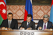
) are mediating efforts to negotiate a full settlement of the conflict, proposing a "a referendum or a plebiscite, at a time to be determined later," to determine the final status of the area, return for some territories under Karabakh's control, and security guarantees. Ilham Aliyev
and Serzh Sarkisian traveled to Moscow
for talks with Dmitry Medvedev
on 2 November 2008. The talks ended in the three Presidents signing a declaration confirming their commitment to continue talks. The two presidents have met again since then, most recently in Saint Petersburg
.
On November 22, 2009, several world leaders, among them the heads of state from Azerbaijan and Armenia, met in Munich
in the hopes of renewing efforts to reach a peaceful settlement on the status of Nagorno-Karabakh. Prior to the meeting, President Aliyev once more threatened to resort to military force to reestablish control over the region if the two sides did not reach an agreeable settlement at the summit.
The ceasefire
agreement is being breached on a regular basis by both sides. Some major incidents and skirmishes include the killing of three Azerbaijani soldiers and wounding one as a result of the ceasefire violation on February 18, 2010
. On November 20 of the same year an Armenian sniper opened fire on Azerbaijani positions in Khojavend Rayon, killing one Azerbaijani soldier. This incident brought the number of soldiers killed from both sides in August—November, 2010 to twelve. On September 25, 2010 the United Nations Secretary-General
Ban Ki-moon
supported the withdrawal of sniper
s from the contact line. The spokesman of Azerbaijani Defence Ministry Lt-Col Eldar Sabiroglu, however, commented that Armenian servicemen used to fire on opposite positions across the contact line from machine
- and submachine gun
s, as well as from grenade launcher
s, and that these weapons have even been used against civilians. On March 8th, 2011, an Armenian Armed Forces sniper positioned in the occupied Azerbaijani territories targeted and killed 9-year-old Fariz Badalov. Badalov's death was condemned by a PACE declaration 12591. On May 18–20, 2010 at the 37th session of the Council of Ministers of Foreign Affairs of the Organization of Islamic Conference in Dushanbe
, another resolution condemning the aggression of Armenia against Azerbaijan, recognizing the actions against Azerbaijani civilians as a crime against humanity and condemning the destruction of archaeological, cultural and religious monuments in occupied territories was adopted. On May 20 of the same year the European Parliament
in Strasbourg
adopted the resolution on "The need for an EU Strategy for the South Caucasus" on the basis of the report by Evgeni Kirilov
, Bulgarian member of the Parliament. The resolution states in particular that "the occupied Azerbaijani regions around Nagorno-Karabakh must be cleared as soon as possible".
On September 12, 2011, a UAV was reportedly shot down over the airspace of the secessionist Nagorno-Karabakh Republic
(near the village of Gülablı
in the district of Khojavend. According to the Armenian side the UAV was shot down by air defense arm of the Nagorno-Karabakh Defense Army
. However according to Israeli sources this was accomplished with the aid of Russian antiaircraft officers who entered the region from neighboring Armenia.
 Nagorno-Karabakh has a total area of 4,400 square kilometers (1,699 sq mi) and is an enclave surrounded entirely by Azerbaijan; its nearest point to Armenia is across the Lachin corridor
, roughly 4 kilometers across. Approximately half of Nagorno-Karabakh terrain is over 950 m above sea level. The borders of Nagorno-Karabakh resemble a kidney bean with the indentation on the east side. It has tall mountain ridges along the northern edge and along the west and a mountainous south. The part near the indentation of the kidney bean itself is a relatively flat valley, with the two edges of the bean, the provinces of Martakert
and Martuni
, having flat lands as well. Other flatter valleys exist around the Sarsang reservoir
, Hadrut
, and the south. The entire region lies, on average, 1100 metres (3,608.9 ft) above sea level. Notable peaks include the border mountain Murovdag
and the Great Kirs mountain chain in the junction of Shusha Rayon and Hadrut
. The territory of modern Nagorno-Karabakh forms a portion of the historic region of Karabakh
, which lies between the rivers Kura
and Araxes, and the modern Armenia-Azerbaijan border. Nagorno-Karabakh in its modern borders is part of the larger region of Upper Karabakh.
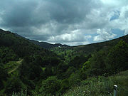
Nagorno-Karabakh’s environment vary from steppe
on the Kura lowland through dense forests of oak
, hornbeam
and beech
on the lower mountain slopes to birchwood
and alpine meadows higher up. The region possesses numerous mineral spring
s and deposits of zinc
, coal
, lead
, gold
, marble
and limestone
. The major cities of the region are Stepanakert
, which serves as the capital of the Nagorno-Karabakh Republic, and Shusha
, which lies partially in ruins. Vineyards, orchards and mulberry groves for silkworms are developed in the valleys.
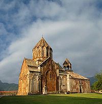
Concrete numbers about the demographic situation in Nagorno Karabakh appear since the 18th century. Archimandrite Minas Tigranian, after completing his secret mission to Persian Armenia ordered by the Russian Tsar Peter the Great stated in a report dated March 14, 1717 that the patriarch of the Gandzasar Monastery
, in Nagorno Karabakh, had under his authority 900 Armenian villages.
In his letter of 1769 to Russia’s Count P. Panin
, the Georgian king Erekle II
, in his description of Nagorno Karabakh, suggests: "Seven families rule the region of Khamse. Its population is totally Armenian
."
When discussing Karabakh and Shusha
in the 18th century, the Russian diplomat and historian S. M. Bronevskiy (Russian: С. М. Броневский) indicated in his Historical Notes that Karabakh, which he said "is located in Greater Armenia" had as many as 30–40,000 armed Armenian men in 1796.
A survey prepared by the Russian imperial authorities in 1823, several years before the 1828 Armenian migration from Persia to the newly established Armenian Province, shows that all Armenians of Karabakh compactly resided in its highland portion, i.e. on the territory of the five traditional Armenian principalities in Nagorno Karabakh, and constituted an absolute demographic majority on those lands. The survey's more than 260 pages recorded that the district of Khachen had twelve Armenian villages and no Tatar (Muslim) villages; Jalapert (Jraberd) had eight Armenian villages and no Tatar villages; Dizak had fourteen Armenian villages and one Tatar village; Gulistan had twelve Armenian and five Tatar villages; and Varanda had twenty-three Armenian villages and one Tatar village.
During the Soviet times, leader of Azerbaijan SSR tried to change demographic balance in the Nagorno Karabakh Autonomous Region (NKAO) by increasing the number of Azerbaijani residents through opening a university with Azerbaijani, Russian and Armenian sectors and a shoe factory, sending Azerbaijanis from other parts of Azerbaijani SSR to the NKAO. "By doing this," Aliyev said in an interview in 2002 "I tried to increase the number of Azeris and to reduce the number of Armenians.”
Nearing the collapse of the Soviet Union
in 1989, the Nagorno-Karabakh Autonomous Oblast boasted a population of 145,593 Armenians (76.4%), 42,871 Azerbaijanis (22.4%), and several thousand Kurds, Russians, Greeks, and Assyrians
. Most of the Azerbaijani and Kurdish populations fled the region during the heaviest years of fighting in the war from 1992 to 1993. The main language spoken in Nagorno-Karabakh is Armenian
; however, Karabakh Armenians speak a dialect of Armenian which is considerably different from that which is spoken in Armenia as it is layered with Russian
, Turkish
and Persian words.
In 2001, the NKR's reported population was 95% Armenian, with the remaining total including Assyrians, Greeks, and Kurds. In March 2007, the local government announced that its population had grown to 138,000. The annual birth rate was recorded at 2,200-2,300 per year, an increase from nearly 1,500 in 1999. Until 2000, the country's net migration was at a negative. For the first half of 2007, 1,010 births and 659 deaths were reported, with a net emigration of 27.
In 2011, officials from YAP
submitted a letter to OSCE which included the statement, "The OSCE fact-finding mission report released last year also found that some 15,000 Armenians have been illegally settled on Azerbaijan's occupied territories." However, the OSCE report, released in March 2011, estimates the population of territories controlled by ethnic Armenians "adjacent to the breakaway Azerbaijani region of Nagorno-Karabakh" to be 14,000, and states "there has been no significant growth in the population since 2005."
Most of the Armenian population is Christian
and belongs to the Armenian Apostolic Church
. Certain Orthodox Christian
and Evangelical Christian denominations also exist; other religions include Judaism
.
Landlocked
A landlocked country is a country entirely enclosed by land, or whose only coastlines lie on closed seas. There are 48 landlocked countries in the world, including partially recognized states...
region in the South Caucasus
South Caucasus
The South Caucasus is a geopolitical region located on the border of Eastern Europe and Southwest Asia also referred to as Transcaucasia, or The Trans-Caucasus...
, lying between Lower Karabakh
Karabakh
The Karabakh horse , also known as Karabakh, is a mountain-steppe racing and riding horse. It is named after the geographic region where the horse was originally developed, Karabakh in the Southern Caucasus, an area that is de jure part of Azerbaijan but the highland part of which is currently...
and Zangezur and covering the southeastern range of the Lesser Caucasus
Lesser Caucasus
Lesser Caucasus is one of the two main mountain ranges of Caucasus mountains, of length about 600 km....
mountains. The region is mostly mountainous and forested and has an area of 4400 square kilometres (1,698.8 sq mi).
Most of the region is governed by the Nagorno-Karabakh Republic
Nagorno-Karabakh Republic
The Nagorno-Karabakh Republic , or Artsakh Republic is a de facto independent republic located in the South Caucasus region of Eurasia...
, a de facto independent, but unrecognized
Diplomatic recognition
Diplomatic recognition in international law is a unilateral political act with domestic and international legal consequences, whereby a state acknowledges an act or status of another state or government in control of a state...
state established on the basis of the Nagorno-Karabakh Autonomous Oblast
Nagorno-Karabakh Autonomous Oblast
The Nagorno-Karabakh Autonomous Oblast was an autonomous oblast within the borders of the Azerbaijan SSR, mostly inhabited by ethnic Armenians and created on July 7, 1923. According to Karl R. DeRouen it was created as an enclave so that a narrow strip of land would separate it from Armenia proper....
within the Azerbaijan SSR
Azerbaijan SSR
The Azerbaijan Soviet Socialist Republic , also known as the Azerbaijan SSR for short, was one of the republics that made up the former Soviet Union....
of the Soviet Union
Soviet Union
The Soviet Union , officially the Union of Soviet Socialist Republics , was a constitutionally socialist state that existed in Eurasia between 1922 and 1991....
. The territory is internationally recognized as part of Azerbaijan
Azerbaijan
Azerbaijan , officially the Republic of Azerbaijan is the largest country in the Caucasus region of Eurasia. Located at the crossroads of Western Asia and Eastern Europe, it is bounded by the Caspian Sea to the east, Russia to the north, Georgia to the northwest, Armenia to the west, and Iran to...
, although it has not exercised power over most of the region since 1991. Since the end of the Nagorno-Karabakh War
Nagorno-Karabakh War
The Nagorno-Karabakh War was an armed conflict that took place from February 1988 to May 1994, in the small enclave of Nagorno-Karabakh in southwestern Azerbaijan, between the majority ethnic Armenians of Nagorno-Karabakh backed by the Republic of Armenia, and the Republic of Azerbaijan...
in 1994, representatives of the governments of Armenia
Armenia
Armenia , officially the Republic of Armenia , is a landlocked mountainous country in the Caucasus region of Eurasia...
and Azerbaijan have been holding peace talks mediated by the OSCE Minsk Group
OSCE Minsk Group
The OSCE Minsk Group was created in 1992 by the Conference on Security and Cooperation in Europe to encourage a peaceful, negotiated resolution to the conflict between Azerbaijan and Armenia over Nagorno-Karabakh.-Founding and members:The Helsinki Additional Meeting of the CSCE Council on 24 March...
on the region's disputed status.
The region is usually equated with the administrative borders of the former Nagorno-Karabakh Autonomous Oblast
Nagorno-Karabakh Autonomous Oblast
The Nagorno-Karabakh Autonomous Oblast was an autonomous oblast within the borders of the Azerbaijan SSR, mostly inhabited by ethnic Armenians and created on July 7, 1923. According to Karl R. DeRouen it was created as an enclave so that a narrow strip of land would separate it from Armenia proper....
within the Azerbaijani SSR comprising an area of 4400 square kilometres (1,698.8 sq mi). The historical area of the region, however, encompasses approximately 8223 square kilometres (3,174.9 sq mi).
Etymology
The word Nagorno- is a RussianRussian language
Russian is a Slavic language used primarily in Russia, Belarus, Uzbekistan, Kazakhstan, Tajikistan and Kyrgyzstan. It is an unofficial but widely spoken language in Ukraine, Moldova, Latvia, Turkmenistan and Estonia and, to a lesser extent, the other countries that were once constituent republics...
attributive adjective, derived from the adjective nagorny (нагорный), which means "highland". The Azerbaijani
Azerbaijani language
Azerbaijani or Azeri or Torki is a language belonging to the Turkic language family, spoken in southwestern Asia by the Azerbaijani people, primarily in Azerbaijan and northwestern Iran...
name of the region includes similar adjectives "dağlıq" (mountainous) or "yuxarı" (upper). Such words are not used in Armenian
Armenian language
The Armenian language is an Indo-European language spoken by the Armenian people. It is the official language of the Republic of Armenia as well as in the region of Nagorno-Karabakh. The language is also widely spoken by Armenian communities in the Armenian diaspora...
name, but appeared in the official name of the region during the Soviet era as Nagorno-Karabakh Autonomous Oblast
Nagorno-Karabakh Autonomous Oblast
The Nagorno-Karabakh Autonomous Oblast was an autonomous oblast within the borders of the Azerbaijan SSR, mostly inhabited by ethnic Armenians and created on July 7, 1923. According to Karl R. DeRouen it was created as an enclave so that a narrow strip of land would separate it from Armenia proper....
. Other languages apply their own wording for mountainous, upper, or highland; for example, the official name used by the Nagorno-Karabakh Republic
Nagorno-Karabakh Republic
The Nagorno-Karabakh Republic , or Artsakh Republic is a de facto independent republic located in the South Caucasus region of Eurasia...
in France is Haut-Karabakh, meaning "Upper Karabakh".
The word Karabakh
Karabakh
The Karabakh horse , also known as Karabakh, is a mountain-steppe racing and riding horse. It is named after the geographic region where the horse was originally developed, Karabakh in the Southern Caucasus, an area that is de jure part of Azerbaijan but the highland part of which is currently...
is generally held to originate from Turkic and Persian
Persian language
Persian is an Iranian language within the Indo-Iranian branch of the Indo-European languages. It is primarily spoken in Iran, Afghanistan, Tajikistan and countries which historically came under Persian influence...
, and literally means "black garden". The name first appears in Georgian
Georgia (country)
Georgia is a sovereign state in the Caucasus region of Eurasia. Located at the crossroads of Western Asia and Eastern Europe, it is bounded to the west by the Black Sea, to the north by Russia, to the southwest by Turkey, to the south by Armenia, and to the southeast by Azerbaijan. The capital of...
and Persian sources of the 13th and 14th centuries. Karabagh is an acceptable alternate spelling of Karabakh, and also denotes a kind of patterned rug
Karabakh carpet
Karabakh carpet is one of four major regional groups of carpets made in Azerbaijan and Armenia named after the Karabakh region, which comprises present Nagorno-Karabakh and adjacent lowland territories .-History:...
originally produced in the area.
In an alternative theory proposed by Bagrat Ulubabyan
Bagrat Ulubabyan
Bagrat Arshaki Ulubabyan was an Armenian writer and historian, known most prominently for his work on the histories of Nagorno-Karabakh and Artsakh.-Early life and education:...
the name Karabakh has a Turkic-Armenian origin, meaning "Greater Baghk" , a reference to Ktish-Baghk (later: Dizak
Dizak
Dizak , also known as Ktish after its main stronghold, was a medieval Armenian principality in the historical Artsakh and later one of the five melikdoms of Karabakh, which included the southern third of Khachen and from the 13th century also the canton of Baghk of Syunik. The founder of this...
), one of the principalities of Artsakh under the rule of the Aranshahik dynasty, which held the throne of the Kingdom of Syunik in the 11th–13th centuries and called itself the "Kingdom of Baghk".
The names for the region in the various local languages all translate to "mountainous Karabakh", or "mountainous black garden":
, transliterated
Transliteration
Transliteration is a subset of the science of hermeneutics. It is a form of translation, and is the practice of converting a text from one script into another...
Leṙnayin Ġarabaġ (mountainous Karabakh) or Yuxarı Qarabağ (upper Karabakh), transliterated Nagornyy Karabakh or Nagornyi Karabah
Nagorno-Karabakh is often referred to by the Armenians
Armenians
Armenian people or Armenians are a nation and ethnic group native to the Armenian Highland.The largest concentration is in Armenia having a nearly-homogeneous population with 97.9% or 3,145,354 being ethnic Armenian....
living in the area as Artsakh
Artsakh
Artsakh was the tenth province of the Kingdom of Armenia from 189 BC until 387 AD and afterwards a region of Caucasian Albania from 387 to the 7th century. From the 7th to 9th centuries, it fell under Arab control...
(Armenian: ), designating the 10th province of the ancient Kingdom of Armenia. In Urartian inscriptions (9th–7th centuries BC), the name Urtekhini is used for the region.
Ancient Greek
Ancient Greek
Ancient Greek is the stage of the Greek language in the periods spanning the times c. 9th–6th centuries BC, , c. 5th–4th centuries BC , and the c. 3rd century BC – 6th century AD of ancient Greece and the ancient world; being predated in the 2nd millennium BC by Mycenaean Greek...
sources called the area Orkhistene.
Early history
Kura-Araxes culture
The Kura-Araxes culture or the Early trans-Caucasian culture, was a civilization that existed from 3400 BC until about 2000 BC. The earliest evidence for this culture is found on the Ararat plain; thence it spread to Georgia by 3000 BC, and during the next millennium it proceeded westward to the...
, who lived between the two rivers Kura
Kura River
Kura is a river, also known from the Greek as the Cyrus in the Caucasus Mountains. Starting in north-eastern Turkey, it flows through Turkey to Georgia, then to Azerbaijan, where it receives the Aras River as a right tributary, and enters the Caspian Sea...
and Araxes.
The original population of the region consisted of various autochthonous
Indigenous peoples
Indigenous peoples are ethnic groups that are defined as indigenous according to one of the various definitions of the term, there is no universally accepted definition but most of which carry connotations of being the "original inhabitants" of a territory....
and migrant tribes. According to the American scholar Robert H. Hewsen
Robert H. Hewsen
Robert H. Hewsen or Hewsenian is Professor Emeritus of History at Rowan University in Glassboro, New Jersey and is an expert on the ancient history of the South Caucasus.-Biography:...
, these primordial tribes were "certainly not of Armenian origin", and "although certain Iranian peoples must have settled here during the long period of Persian and Median rule, most of the natives were not even Indo-Europeans".
However, relying on information provided by the 5th century Armenian historian Movses Khorenatsi
Movses Khorenatsi
Moses of Chorene, also Moses of Khoren, Moses Chorenensis, or Movses Khorenatsi , or a 7th to 9th century date) was an Armenian historian, and author of the History of Armenia....
, other Western authors argued—and Hewsen himself indicated later—that these peoples could have been conquered by the Kingdom of Armenia
Kingdom of Armenia
The ancient Kingdom of Armenia was an independent monarchy from 331 BC to AD 428. The peak of the kingdom's power and its integration in Hellenistic culture under Tigranes and his son Artavasdes is also referred to as Armenian Empire. After the fall of the Achaemenid Empire, the former Satrapy of...
much earlier, in the 4th century BC.
Overall, from around 180 BC and up until the 4th century AD — before becoming part of the Armenian Kingdom again, in 855 — the territory of Nagorno-Karabakh remained part of the united Armenian Kingdom as the province of Artsakh
Artsakh
Artsakh was the tenth province of the Kingdom of Armenia from 189 BC until 387 AD and afterwards a region of Caucasian Albania from 387 to the 7th century. From the 7th to 9th centuries, it fell under Arab control...
.
After the partition of Armenia between Byzantium
Byzantium
Byzantium was an ancient Greek city, founded by Greek colonists from Megara in 667 BC and named after their king Byzas . The name Byzantium is a Latinization of the original name Byzantion...
and Persia, in 387 AD, Artsakh
Artsakh
Artsakh was the tenth province of the Kingdom of Armenia from 189 BC until 387 AD and afterwards a region of Caucasian Albania from 387 to the 7th century. From the 7th to 9th centuries, it fell under Arab control...
became part of Caucasian Albania
Caucasian Albania
Albania is a name for the historical region of the eastern Caucasus, that existed on the territory of present-day republic of...
, which, in turn, came under strong Armenian religious and cultural influence. In the works of Movses Kaghankatvatsi
Movses Kaghankatvatsi
Movses Kaghankatvatsi , or Movses Daskhurantsi , is the reputed author of a 10th-century Old Armenian historiographical work on Caucasian Albania, known as The History of the Country of Albania .- Authorship :...
, Aran gets appointed to rule Aghvank
Caucasian Albania
Albania is a name for the historical region of the eastern Caucasus, that existed on the territory of present-day republic of...
by Vagharshak, King of Armenia
Armenia
Armenia , officially the Republic of Armenia , is a landlocked mountainous country in the Caucasus region of Eurasia...
. Armenians have lived in the Karabakh region since Roman
Ancient Rome
Ancient Rome was a thriving civilization that grew on the Italian Peninsula as early as the 8th century BC. Located along the Mediterranean Sea and centered on the city of Rome, it expanded to one of the largest empires in the ancient world....
times: Strabo
Strabo
Strabo, also written Strabon was a Greek historian, geographer and philosopher.-Life:Strabo was born to an affluent family from Amaseia in Pontus , a city which he said was situated the approximate equivalent of 75 km from the Black Sea...
states that, by the second or first century BC, the entire population of Greater Armenia—Artsakh
Artsakh
Artsakh was the tenth province of the Kingdom of Armenia from 189 BC until 387 AD and afterwards a region of Caucasian Albania from 387 to the 7th century. From the 7th to 9th centuries, it fell under Arab control...
and Utik
Utik
Utik was a historic province of the Kingdom of Armenia and a region of Caucasian Albania. Most of the region is located within present-day Azerbaijan immediately west of the Kura River while a part of it lies within the Tavush province of present-day northeastern Armenia.-History:According to...
included—spoke Armenian, though this does not mean that its population consisted exclusively of ethnic Armenians. Tigran the Great, King of Armenia, (ruled 95–55 BC), founded in Artsakh one of four cities named “Tigranakert” after himself. The ruins of the ancient Tigranakert, located 30 miles north-east of Stepanakert
Stepanakert
Stepanakert is the largest city and capital of the Nagorno-Karabakh Republic, a de facto independent republic, though is internationally recognized as a part of Azerbaijan...
, are being studied by a group of international scholars.
By the early Middle Ages
Middle Ages
The Middle Ages is a periodization of European history from the 5th century to the 15th century. The Middle Ages follows the fall of the Western Roman Empire in 476 and precedes the Early Modern Era. It is the middle period of a three-period division of Western history: Classic, Medieval and Modern...
, the non-Armenian elements of Caucasian Albanian population of upper Karabakh had completed their merger into the Armenian population, and forever disappeared as identifiable groups. Armenian culture and civilization flourished in the early medieval Nagorno Karabakh— in Artsakh
Artsakh
Artsakh was the tenth province of the Kingdom of Armenia from 189 BC until 387 AD and afterwards a region of Caucasian Albania from 387 to the 7th century. From the 7th to 9th centuries, it fell under Arab control...
and Utik
Utik
Utik was a historic province of the Kingdom of Armenia and a region of Caucasian Albania. Most of the region is located within present-day Azerbaijan immediately west of the Kura River while a part of it lies within the Tavush province of present-day northeastern Armenia.-History:According to...
. In the 5th century, the first-ever Armenian school was opened on the territory of modern Nagorno-Karabakh—at the Amaras Monastery
Amaras Monastery
Amaras Monastery is one of the oldest Christian sites in the world and in Nagorno-Karabakh, and is an Armenian Apostolic monastery located near the village of Sos in the Martuni county of the Nagorno-Karabakh Republic.- History :...
—by the efforts of St. Mesrob Mashtots, the inventor of the Armenian Alphabet
Armenian alphabet
The Armenian alphabet is an alphabet that has been used to write the Armenian language since the year 405 or 406. It was devised by Saint Mesrop Mashtots, an Armenian linguist and ecclesiastical leader, and contained originally 36 letters. Two more letters, օ and ֆ, were added in the Middle Ages...
. St. Mesrob was very active in preaching Gospel in Artsakh
Artsakh
Artsakh was the tenth province of the Kingdom of Armenia from 189 BC until 387 AD and afterwards a region of Caucasian Albania from 387 to the 7th century. From the 7th to 9th centuries, it fell under Arab control...
and Utik
Utik
Utik was a historic province of the Kingdom of Armenia and a region of Caucasian Albania. Most of the region is located within present-day Azerbaijan immediately west of the Kura River while a part of it lies within the Tavush province of present-day northeastern Armenia.-History:According to...
. Four chapters of Movses Kaghankatvatsi
Movses Kaghankatvatsi
Movses Kaghankatvatsi , or Movses Daskhurantsi , is the reputed author of a 10th-century Old Armenian historiographical work on Caucasian Albania, known as The History of the Country of Albania .- Authorship :...
’s “History...” amply describe St. Mesrob’s mission, referring to him as “enlightener,” “evangelizer” and “saint”. Overall, Mesrob Mashtots made three trips to Artsakh
Artsakh
Artsakh was the tenth province of the Kingdom of Armenia from 189 BC until 387 AD and afterwards a region of Caucasian Albania from 387 to the 7th century. From the 7th to 9th centuries, it fell under Arab control...
and Utik
Utik
Utik was a historic province of the Kingdom of Armenia and a region of Caucasian Albania. Most of the region is located within present-day Azerbaijan immediately west of the Kura River while a part of it lies within the Tavush province of present-day northeastern Armenia.-History:According to...
, ultimately reaching pagan territories at the foothills of the Greater Caucasus
Greater Caucasus
Greater Caucasus , sometimes translated as "Caucasus Major", "Big Caucasus" or "Large Caucasus") is the major mountain range of the Caucasus Mountains....
.
It was at that time when the foremost Armenian historian Movses Khorenatsi
Movses Khorenatsi
Moses of Chorene, also Moses of Khoren, Moses Chorenensis, or Movses Khorenatsi , or a 7th to 9th century date) was an Armenian historian, and author of the History of Armenia....
confirmed that the Kura River formed "the boundary of Armenian speech." The 7th-century Armenian linguist and grammarian Stephanos Syunetsi stated in his work that Armenians of Artsakh had their own dialect, and encouraged his readers to learn it. In the same 7th century, Armenian poet Davtak Kertogh
Davtak Kertogh
Davtak Kertogh was a 7th century Armenian poet, the first secular writer in Armenian literature. He is the author of "Elegy on the Death of the Great Prince Jevansher", dedicated to the first Sassanid Persian prince of Caucasian Albania, who accepted Christianity and was murdered.The only...
writes his Elegy on the Death of Grand Prince Juansher, where each passage begins with a letter of Armenian script in alphabetical order. The only comprehensive history of the Kingdom of Aghvank was written in Armenian, by the historian Movses Kaghankatvatsi
Movses Kaghankatvatsi
Movses Kaghankatvatsi , or Movses Daskhurantsi , is the reputed author of a 10th-century Old Armenian historiographical work on Caucasian Albania, known as The History of the Country of Albania .- Authorship :...
.
In the 7th and 8th centuries, the region was ruled by Caliphate
Caliphate
The term caliphate, "dominion of a caliph " , refers to the first system of government established in Islam and represented the political unity of the Muslim Ummah...
-appointed local governors. In 821 the Armenian prince Sahl Smbatian revolted in Artsakh and established the House of Khachen, which ruled Artsakh as a principality until the early 19th century. The name “Khachen” originated from Armenian word “khach,” which means “cross”. By 1000 the House of Khachen proclaimed the Kingdom of Artsakh
Kingdom of Artsakh
The Kingdom of Artsakh is the modern name given to the medieval eastern Armenian state on the territory of Artsakh , Gardman and Gegharkunik. Contempororay sources referred to it as the "kingdom of Aghuank" or "Khachen". The royal house of Artsakh was a cadet branch of the ancient Syunid dynasty...
with John Senecherib as its first ruler. Initially Dizak
Dizak
Dizak , also known as Ktish after its main stronghold, was a medieval Armenian principality in the historical Artsakh and later one of the five melikdoms of Karabakh, which included the southern third of Khachen and from the 13th century also the canton of Baghk of Syunik. The founder of this...
, in southern Artsakh, formed also a kingdom ruled by the ancient House of Aranshahik, descended of the earliest Kings of Caucasian Albania. In 1261, after the daughter of the last king of Dizak married to the king of Artsakh, the two states merged into one. Subsequently Artsakh continued to exist as a principality.
In the 15th century, the territory of Karabakh was part of the states ruled by Kara Koyunlu
Kara Koyunlu
The Kara Koyunlu or Qara Qoyunlu, also called the Black Sheep Turkomans , were a Shi'ite Oghuz Turkic tribal federation that ruled over the territory comprising the present-day Armenia, Azerbaijan, north-western Iran, eastern Turkey and Iraq from about 1375 to 1468.The Kara Koyunlu Turkomans at one...
and Ak Koyunlu
Ak Koyunlu
The Aq Qoyunlu or Ak Koyunlu, also called the White Sheep Turkomans , was an Sunni Oghuz Turkic tribal federation that ruled parts of present-day Eastern Turkey, Armenia, Azerbaijan, northern Iraq, and Iran from 1378 to 1508.-History:According to chronicles from the Byzantine Empire, the Aq Qoyunlu...
tribal confederations. The Turkoman
Turkmen people
The Turkmen are a Turkic people located primarily in the Central Asian states of Turkmenistan, Afghanistan, and northeastern Iran. They speak the Turkmen language, which is classified as a part of the Western Oghuz branch of the Turkic languages family together with Turkish, Azerbaijani, Qashqai,...
lord Jahan Shah
Jahan Shah
Muzaffar al-Din Jahan Shah ibn Yusuf was the leader of the Kara Koyunlu Turkmen tribal federation in Azerbaijan and Arran who reigned c.1438-1467. During his reign he managed to expand the Kara Koyunlu’s territory to its largest extent, including Western Anatolia, most of present day Iraq,...
(1437–67) assigned the governship of upper Karabakh to local Armenian princes, allowing a native Armenian leadership to emerge consisting of five noble families led by princes who held the titles of melik
Melik
Мelik , from malik ) was a hereditary Armenian noble title, in various Eastern Armenian principalities known as melikdoms encompassing modern Yerevan, Kars, Nakhchivan, Sevan, Lori, Artsakh, Tabriz and Syunik starting from the Late Middle Ages until the end of the nineteenth century...
s. These dynasties represented the branches of the earlier House of Khachen and were the descendants of the medieval kings of Artsakh. Their lands were often referred to as the Country of Khamsa (five in Arabic
Arabic language
Arabic is a name applied to the descendants of the Classical Arabic language of the 6th century AD, used most prominently in the Quran, the Islamic Holy Book...
). The Russian Empire
Russian Empire
The Russian Empire was a state that existed from 1721 until the Russian Revolution of 1917. It was the successor to the Tsardom of Russia and the predecessor of the Soviet Union...
recognized the sovereign
Sovereignty
Sovereignty is the quality of having supreme, independent authority over a geographic area, such as a territory. It can be found in a power to rule and make law that rests on a political fact for which no purely legal explanation can be provided...
status of the five princes in their domains by a charter of the Emperor Paul I
Paul I of Russia
Paul I was the Emperor of Russia between 1796 and 1801. He also was the 72nd Prince and Grand Master of the Order of Malta .-Childhood:...
dated 2 June 1799.
In the early 16th century, after the fall of the Ak Koyunlu state, control of the region passed to the Safavid dynasty
Safavid dynasty
The Safavid dynasty was one of the most significant ruling dynasties of Iran. They ruled one of the greatest Persian empires since the Muslim conquest of Persia and established the Twelver school of Shi'a Islam as the official religion of their empire, marking one of the most important turning...
, which created the Karabakh Beylerbeylik
Karabakh Beylerbeylik
At the time of the Safavid state, the entire territory of Azerbaijan was made up of four beylerbeydoms: Shirvan, Karabakh , Chukhursaad and Azerbaijan .Rahmani A. A. Azerbaijan in the late 16th and 17th centuries . Baku,1981, pp...
. Despite these conquests, the population of Upper Karabakh remained largely Armenian. Initially under the control of the Ganja Khanate
Ganja Khanate
The Ganja khanate was a Muslim principality mostly under the dominion of Persia that existed in the territory of Azerbaijan in 1747-1805. The principality was ruled by the dynasty of Ziyadoglu , which had ruled Ganja as governors under Nadir Shah and was of Qajar extraction...
of the Persian Empire, the local Armenian princes were granted a wide degree of autonomy by the Safavid Empire over the modern territory of Nagorno Karabakh and adjacent lands.
The Armenian meliks maintained full control over the region until the mid-18th century. In the early 18th century, Persia's Nader Shah
Nader Shah
Nāder Shāh Afshār ruled as Shah of Iran and was the founder of the Afsharid dynasty. Because of his military genius, some historians have described him as the Napoleon of Persia or the Second Alexander...
took Karabakh out of control of the Ganja khans in punishment for their support of the Safavids, and placed it under his own control At the same time, the Armenian meliks were granted supreme command over neighboring Armenian principalities and Muslim khans in the Caucasus, in return for the meliks' victories over the invading Ottoman
Ottoman Empire
The Ottoman EmpireIt was usually referred to as the "Ottoman Empire", the "Turkish Empire", the "Ottoman Caliphate" or more commonly "Turkey" by its contemporaries...
Turks
Ottoman Turks
The Ottoman Turks were the Turkish-speaking population of the Ottoman Empire who formed the base of the state's military and ruling classes. Reliable information about the early history of Ottoman Turks is scarce, but they take their Turkish name, Osmanlı , from the house of Osman I The Ottoman...
in the 1720s. These five principalities in Karabakh were ruled by Armenian families who had received the title Melik (prince) and were the following: the principality of Gulistan, under the leadership of the Melik Biglarian family, the principality of Djrabert under the leadership of the Melik Israelian family, the principality of Khatchen, under the leadership of the Hassan Djalalian family, the principality of Varanda, under the leadership of the Melik Shahnazarian and finally, the principality of Tizk, under the leadership of the Melik Avanian family. In the mid-18th century, as internal conflicts between the meliks led to their weakening, the Karabakh khanate
Karabakh khanate
The Karabakh khanate was a semi-independent khanate on the territories of modern Azerbaijan and Armenia established in about 1750 under Persian suzerainty in Karabakh and adjacent areas. The Karabakh khanate existed until 1805, when the Russian Empire gained control over it from Persia...
was formed.
Karabakh became a protectorate
Protectorate
In history, the term protectorate has two different meanings. In its earliest inception, which has been adopted by modern international law, it is an autonomous territory that is protected diplomatically or militarily against third parties by a stronger state or entity...
of the Imperial Russia by the Kurekchay Treaty
Kurekchay Treaty
The Treaty of Kurakchay, also known as the Russo-Karabakhi treaty of May 14, 1805, was a treaty signed between the Russian military commander in the Caucasus Pavel Tsitsianov on behalf of Tsar Alexander I of Russia and Ibrahim Khalil Khan of the Karabakh khanate, which made the khanate a...
, signed between Ibrahim Khalil Khan
Ibrahim Khalil Khan
Ibrahim Khalil khan Javanshir was the Azeri Turkic khan of Karabakh from the Javanshir family, who succeeded his father Panah-Ali khan Javanshir as the ruler of Karabakh khanate....
of Karabakh and general Pavel Tsitsianov
Pavel Tsitsianov
Pavel Dmitriyevich Tsitsianov was the Georgian Imperial Russian military commander and infantry general from 1804. A member of the noble Georgian family Tsitsishvili , Tsitsianov participated in suppression of the Kościuszko Uprising and in the Russo-Persian War...
on behalf of Tsar
Tsar
Tsar is a title used to designate certain European Slavic monarchs or supreme rulers. As a system of government in the Tsardom of Russia and Russian Empire, it is known as Tsarist autocracy, or Tsarism...
Alexander I
Alexander I of Russia
Alexander I of Russia , served as Emperor of Russia from 23 March 1801 to 1 December 1825 and the first Russian King of Poland from 1815 to 1825. He was also the first Russian Grand Duke of Finland and Lithuania....
in 1805, according to which the Russian monarch recognized Ibrahim Khalil Khan and his descendants as the sole hereditary rulers of the region. Its new status was confirmed under the terms of the Treaty of Gulistan (1823), when Persia formally ceded Karabakh to the Russian Empire, before the rest of Transcaucasia was incorporated into the Empire in 1828 by the Treaty of Turkmenchay
Treaty of Turkmenchay
The Treaty of Turkmenchay was a treaty negotiated in Turkmenchay by which the Qajar Empire recognized Russian suzerainty over the Erivan khanate, the Nakhchivan khanate, and the remainder of the Talysh khanate, establishing the Aras River as the common boundary between the empires, after its...
.
In 1822, the Karabakh khanate was dissolved, and the area became part of the Elisabethpol Governorate
Elisabethpol Governorate
Elisabethpol Governorate or Elizavetpol Governorate was one of the guberniyas of the Russian Empire, with its centre in Elisabethpol . Its area was 44,136 sq. kilometres, and it had 878,415 inhabitants by 1897....
within the Russian Empire
Russian Empire
The Russian Empire was a state that existed from 1721 until the Russian Revolution of 1917. It was the successor to the Tsardom of Russia and the predecessor of the Soviet Union...
. After the transfer of the Karabakh khanate to Russia, many Azerbaijani Muslim families emigrated to Persia, while many Armenians were induced by the Russian government to emigrate from Persia to Karabakh.
Soviet era
The present-day conflict over Nagorno-Karabakh has its roots in the decisions made by Joseph StalinJoseph Stalin
Joseph Vissarionovich Stalin was the Premier of the Soviet Union from 6 May 1941 to 5 March 1953. He was among the Bolshevik revolutionaries who brought about the October Revolution and had held the position of first General Secretary of the Communist Party of the Soviet Union's Central Committee...
and the Caucasian Bureau () during the Sovietization
Sovietization
Sovietization is term that may be used with two distinct meanings:*the adoption of a political system based on the model of soviets .*the adoption of a way of life and mentality modelled after the Soviet Union....
of Transcaucasia. Stalin was the acting Commissar of Nationalities
Narkomnats
People's Commissariat of Nationalities was the Government of the Soviet Union body set up to deal with non-Russian nationalities...
for the Soviet Union during the early 1920s, the branch of the government under which the Kavburo was created. After the Russian Revolution of 1917
Russian Revolution of 1917
The Russian Revolution is the collective term for a series of revolutions in Russia in 1917, which destroyed the Tsarist autocracy and led to the creation of the Soviet Union. The Tsar was deposed and replaced by a provisional government in the first revolution of February 1917...
, Karabakh became part of the Transcaucasian Democratic Federative Republic
Transcaucasian Democratic Federative Republic
The Transcaucasian Democratic Federative Republic , was a short-lived state composed of the modern-day countries of Armenia, Azerbaijan, and Georgia in the South Caucasus.-...
, but this soon dissolved into separate Armenia
Armenia
Armenia , officially the Republic of Armenia , is a landlocked mountainous country in the Caucasus region of Eurasia...
n, Azerbaijan
Azerbaijan
Azerbaijan , officially the Republic of Azerbaijan is the largest country in the Caucasus region of Eurasia. Located at the crossroads of Western Asia and Eastern Europe, it is bounded by the Caspian Sea to the east, Russia to the north, Georgia to the northwest, Armenia to the west, and Iran to...
i, and Georgian
Georgia (country)
Georgia is a sovereign state in the Caucasus region of Eurasia. Located at the crossroads of Western Asia and Eastern Europe, it is bounded to the west by the Black Sea, to the north by Russia, to the southwest by Turkey, to the south by Armenia, and to the southeast by Azerbaijan. The capital of...
states. Over the next two years (1918–20), there were a series of short wars between Armenia and Azerbaijan over several regions, including Karabakh. In July 1918, the First Armenian Assembly of Nagorno-Karabakh declared the region self-governing and created a National Council and government. Later, Ottoman troops entered Karabakh, meeting armed resistance by Armenians.
After the defeat of Ottoman Empire
Ottoman Empire
The Ottoman EmpireIt was usually referred to as the "Ottoman Empire", the "Turkish Empire", the "Ottoman Caliphate" or more commonly "Turkey" by its contemporaries...
in World War I
World War I
World War I , which was predominantly called the World War or the Great War from its occurrence until 1939, and the First World War or World War I thereafter, was a major war centred in Europe that began on 28 July 1914 and lasted until 11 November 1918...
, British
United Kingdom
The United Kingdom of Great Britain and Northern IrelandIn the United Kingdom and Dependencies, other languages have been officially recognised as legitimate autochthonous languages under the European Charter for Regional or Minority Languages...
troops occupied Karabakh. The British command provisionally affirmed Khosrov bey Sultanov
Khosrov bey Sultanov
Khosrov bey Sultanov Pasha bey oglu , also spelled as Khosrow Sultanov, was an Azerbaijani statesman, General Governor of Karabakh and Minister of Defense of Azerbaijani Democratic Republic.-Early life:...
(appointed by the Azerbaijani government) as the governor-general of Karabakh and Zangezur
Kapan
-Notable landmarks:*Vahanavank monastery*Baghaberd and Halidzor Fortresses.*Tatev Monastery - This monastery, situated northwest of Kapan was founded in the ninth century in the place of an ancient tabernacle well-known in ancient times...
, pending final decision by the Paris Peace Conference
Paris Peace Conference, 1919
The Paris Peace Conference was the meeting of the Allied victors following the end of World War I to set the peace terms for the defeated Central Powers following the armistices of 1918. It took place in Paris in 1919 and involved diplomats from more than 32 countries and nationalities...
. The decision was opposed by Karabakh Armenians. In February 1920, the Karabakh National Council preliminarily agreed to Azerbaijani jurisdiction, while Armenians elsewhere in Karabakh continued guerrilla fighting, never accepting the agreement. The agreement itself was soon annulled by the Ninth Karabagh Assembly, which declared union with Armenia in April.
In April 1920, while the Azerbaijani army was locked in Karabakh fighting local Armenian forces, Azerbaijan was taken over by Bolshevik
Bolshevik
The Bolsheviks, originally also Bolshevists , derived from bol'shinstvo, "majority") were a faction of the Marxist Russian Social Democratic Labour Party which split apart from the Menshevik faction at the Second Party Congress in 1903....
s. On August 10, 1920, Armenia signed a preliminary agreement with the Bolsheviks, agreeing to a temporary Bolshevik occupation of these areas until final settlement would be reached. In 1921, Armenia and Georgia were also taken over by the Bolsheviks who, in order to attract public support, promised they would allot Karabakh to Armenia, along with Nakhchivan and Zangezur (the strip of land separating Nakhchivan from Azerbaijan proper). However, the Soviet Union also had far-reaching plans concerning Turkey
Turkey
Turkey , known officially as the Republic of Turkey , is a Eurasian country located in Western Asia and in East Thrace in Southeastern Europe...
, hoping that it would, with a little help from them, develop along Communist lines. Needing to placate Turkey, the Soviet Union agreed to a division under which Zangezur would fall under the control of Armenia, while Karabakh and Nakhchivan would be under the control of Azerbaijan. Had Turkey not been an issue, Stalin would likely have left Karabakh under Armenian control. As a result, the Nagorno-Karabakh Autonomous Oblast
Nagorno-Karabakh Autonomous Oblast
The Nagorno-Karabakh Autonomous Oblast was an autonomous oblast within the borders of the Azerbaijan SSR, mostly inhabited by ethnic Armenians and created on July 7, 1923. According to Karl R. DeRouen it was created as an enclave so that a narrow strip of land would separate it from Armenia proper....
was established within the Azerbaijan SSR
Azerbaijan SSR
The Azerbaijan Soviet Socialist Republic , also known as the Azerbaijan SSR for short, was one of the republics that made up the former Soviet Union....
on July 7, 1923.
With the Soviet Union firmly in control of the region, the conflict over the region died down for several decades. With the beginning of the dissolution of the Soviet Union in the late 1980s and early 1990s, the question of Nagorno-Karabakh re-emerged. Accusing the Azerbaijani SSR government of conducting forced azerification of the region, the majority Armenian population, with ideological and material support from the Armenian SSR
Armenian SSR
The Armenian Soviet Socialist Republic The Armenian Soviet Socialist Republic The Armenian Soviet Socialist Republic The Armenian Soviet Socialist Republic The Armenian Soviet Socialist Republic The Armenian Soviet Socialist Republic The Armenian Soviet Socialist Republic The Armenian Soviet...
, started a movement to have the autonomous oblast transferred to the Armenian SSR. The oblast's borders were drawn to include Armenian villages and to exclude as much as possible Azerbaijani villages. The resulting district ensured an Armenian majority.
War and secession
Agdam (rayon)
Agdam is a rayon in southwestern Azerbaijan. Its capital is the city of Agdam, which is currently a ghost town. It is a disputed region, with the western half controlled by the Nagorno-Karabakh Republic....
against the Armenian populated town of Askeran
Askeran
Askeran is one of the eight provinces of the unrecognised Nagorno-Karabakh Republic , coterminous with the Azerbaijani rayon of Khojali. It is in the center of the NKR, surrounding its capital city of Stepanakert.- Geography :...
, "wreaking destruction en route." The confrontation between the Azeris and the police near Askeran
Askeran
Askeran is one of the eight provinces of the unrecognised Nagorno-Karabakh Republic , coterminous with the Azerbaijani rayon of Khojali. It is in the center of the NKR, surrounding its capital city of Stepanakert.- Geography :...
degenerated into the Askeran clash
Askeran clash
The Askeran clash on 22—23 February 1988 in the town of Askeran was one of the starting points of Armenian-Azerbaijani conflict, which triggered the Nagorno-Karabakh War.- Background and clash :...
, which left two Azeris dead, one of them reportedly killed by an Azeri police officer, as well as 50 Armenian villagers, and an unknown number of Azerbaijanis and police, injured. Large numbers of refugees left Armenia and Azerbaijan as violence began against the minority populations of the respective countries. In the fall of 1989, intensified inter-ethnic conflict in and around Nagorno-Karabakh led the Soviet Union to grant Azerbaijani authorities greater leeway in controlling the region. On November 29, 1989 direct rule in Nagorno-Karabakh was ended and the region was returned to Azerbaijani administration. The Soviet policy backfired, however, when a joint session of the Armenian Supreme Soviet
Supreme Soviet
The Supreme Soviet of the Soviet Union was the Supreme Soviet in the Soviet Union and the only one with the power to pass constitutional amendments...
and the National Council, the legislative body of Nagorno-Karabakh, proclaimed the unification of Nagorno-Karabakh with Armenia. In 1989, Nagorno-Karabakh had a population of 192,000. The population at that time was 76% Armenian and 23% Azerbaijanis
Azerbaijani people
The Azerbaijanis are a Turkic-speaking people living mainly in northwestern Iran and the Republic of Azerbaijan, as well as in the neighbourhood states, Georgia, Russia and formerly Armenia. Commonly referred to as Azeris or Azerbaijani Turks , they also live in a wider area from the Caucasus to...
, with Russia
Russia
Russia or , officially known as both Russia and the Russian Federation , is a country in northern Eurasia. It is a federal semi-presidential republic, comprising 83 federal subjects...
n and Kurdish minorities. On November 26, 1991 Azerbaijan abolished the status of Nagorno-Karabakh Autonomous Oblast
Law on Abolishment of Nagorno-Karabakh Autonomous Oblast
Law on Abolishment of Nagorno-Karabakh Autonomous Oblast is the Resolution No. 279-XII passed by the National Assembly of Azerbaijan and signed into law by the President of Azerbaijan Ayaz Mutalibov on November 26, 1991.-History:...
, rearranging the administrative division and bringing the territory under direct control of Azerbaijan.
On December 10, 1991 in a referendum boycotted by local Azerbaijanis, Armenians in Nagorno-Karabakh approved the creation of an independent state. A Soviet proposal for enhanced autonomy for Nagorno-Karabakh within Azerbaijan satisfied neither side, and a full-scale war
Nagorno-Karabakh War
The Nagorno-Karabakh War was an armed conflict that took place from February 1988 to May 1994, in the small enclave of Nagorno-Karabakh in southwestern Azerbaijan, between the majority ethnic Armenians of Nagorno-Karabakh backed by the Republic of Armenia, and the Republic of Azerbaijan...
subsequently erupted between Azerbaijan and Nagorno-Karabakh, the latter receiving support from Armenia. According to Armenia's former president, Levon Ter-Petrossian
Levon Ter-Petrossian
Levon Ter-Petrossian , sometimes transliterated Levon Ter-Petrosyan or Ter-Petrosian , was the first President of Armenia from 1991 to 1998...
, the Karabakh leadership approach was maximalist and “they thought they could get more.”
The struggle over Nagorno-Karabakh escalated after both Armenia and Azerbaijan attained independence from the Soviet Union in 1991. In the post-Soviet power vacuum
Power vacuum
A power vacuum is, in its broadest sense, an expression for a condition that exists when someone has lost control of something and no one has replaced them. It is usually used to refer to a political situation that can occur when a government has no identifiable central authority...
, military action between Azerbaijan and Armenia was heavily influenced by the Russian military. Furthermore, both the Armenian and Azerbaijani military employed a large number of mercenaries from Ukraine
Ukraine
Ukraine is a country in Eastern Europe. It has an area of 603,628 km², making it the second largest contiguous country on the European continent, after Russia...
and Russia
Russia
Russia or , officially known as both Russia and the Russian Federation , is a country in northern Eurasia. It is a federal semi-presidential republic, comprising 83 federal subjects...
. As many as one thousand Afghan
Afghanistan
Afghanistan , officially the Islamic Republic of Afghanistan, is a landlocked country located in the centre of Asia, forming South Asia, Central Asia and the Middle East. With a population of about 29 million, it has an area of , making it the 42nd most populous and 41st largest nation in the world...
mujahideen
Mujahideen
Mujahideen are Muslims who struggle in the path of God. The word is from the same Arabic triliteral as jihad .Mujahideen is also transliterated from Arabic as mujahedin, mujahedeen, mudžahedin, mudžahidin, mujahidīn, mujaheddīn and more.-Origin of the concept:The beginnings of Jihad are traced...
participated in the fighting on Azerbaijan's side. There were also fighters from Chechnya
Chechnya
The Chechen Republic , commonly referred to as Chechnya , also spelled Chechnia or Chechenia, sometimes referred to as Ichkeria , is a federal subject of Russia . It is located in the southeastern part of Europe in the Northern Caucasus mountains. The capital of the republic is the city of Grozny...
fighting on the side of Azerbaijan. Many survivors from the Azerbaijani side found shelter in 12 emergency camps set up in other parts of Azerbaijan to cope with the growing number of internally displaced people due to the Nagorno-Karabakh war.
By the end of 1993, the conflict had caused thousands of casualties and created hundreds of thousands of refugees on both sides. By May 1994, the Armenians were in control of 14% of the territory of Azerbaijan. At that stage, for the first time during the conflict, the Azerbaijani government recognized Nagorno-Karabakh as a third party in the war, and started direct negotiations with the Karabakh authorities. As a result, a cease-fire was reached on May 12, 1994 through Russian negotiation.
Contemporary situation (since 1994)
Parliamentary Assembly of the Council of Europe
The Parliamentary Assembly of the Council of Europe , which held its first session in Strasbourg on 10 August 1949, can be considered the oldest international parliamentary assembly with a pluralistic composition of democratically elected members of parliament established on the basis of an...
adopted Resolution 1416, which condemns the use of ethnic cleansing against the Azerbaijani population, and supporting the occupation of Azerbaijani territory. On 15–17 May 2007 the 34th session of the Council of Ministers of Foreign Affairs of the Organization of Islamic Conference adopted resolution № 7/34-P, considering the occupation of Azerbaijani territory as the aggression of Armenia against Azerbaijan and recognizing the actions against Azerbaijani civilians as a crime against humanity, and condemns the destruction of archaeological, cultural and religious monuments in the occupied territories.
At the 11th session of the summit of the Organization of the Islamic Conference
Organization of the Islamic Conference
The Organisation of Islamic Cooperation Upon the groups's renaming, some sources provided the English-language translation "Organisation of the Islamic Cooperation", but and have since indicated the preferred English translation omits the "the". is an international organisation consisting of 57...
held on March 13–14, 2008 in Dakar
Dakar
Dakar is the capital city and largest city of Senegal. It is located on the Cap-Vert Peninsula on the Atlantic coast and is the westernmost city on the African mainland...
, resolution № 10/11-P (IS) was adopted. According to the resolution, OIC member states condemned the occupation of Azerbaijani lands by Armenian forces and Armenian aggression against Azerbaijan, alleged ethnic cleansing against the Azeri population, and charged Armenia with the "destruction of cultural monuments in the occupied Azerbaijani territories." On May 14 of the same year the UN General Assembly adopted Resolution № 62/243
United Nations General Assembly Resolution 62/243
United Nations General Assembly Resolution 62/243, titled "The Situation in the Occupied Territories of Azerbaijan", is a resolution of the United Nations General Assembly about the situation in Nagorno-Karabakh, which was adopted on March 14, 2008 at the 62nd session of the General Assembly...
which "demands the immediate, complete and unconditional withdrawal of all Armenian forces from all occupied territories of the Republic of Azerbaijan". As of August 2008, the United States, France, and Russia (the co-chairs of the OSCE Minsk Group
OSCE Minsk Group
The OSCE Minsk Group was created in 1992 by the Conference on Security and Cooperation in Europe to encourage a peaceful, negotiated resolution to the conflict between Azerbaijan and Armenia over Nagorno-Karabakh.-Founding and members:The Helsinki Additional Meeting of the CSCE Council on 24 March...
) are mediating efforts to negotiate a full settlement of the conflict, proposing a "a referendum or a plebiscite, at a time to be determined later," to determine the final status of the area, return for some territories under Karabakh's control, and security guarantees. Ilham Aliyev
Ilham Aliyev
Ilham Heydar oglu Aliyev is the President of Azerbaijan since 2003. He also functions as the Chairman of the New Azerbaijan Party and the head of the National Olympic Committee...
and Serzh Sarkisian traveled to Moscow
Moscow
Moscow is the capital, the most populous city, and the most populous federal subject of Russia. The city is a major political, economic, cultural, scientific, religious, financial, educational, and transportation centre of Russia and the continent...
for talks with Dmitry Medvedev
Dmitry Medvedev
Dmitry Anatolyevich Medvedev is the third President of the Russian Federation.Born to a family of academics, Medvedev graduated from the Law Department of Leningrad State University in 1987. He defended his dissertation in 1990 and worked as a docent at his alma mater, now renamed to Saint...
on 2 November 2008. The talks ended in the three Presidents signing a declaration confirming their commitment to continue talks. The two presidents have met again since then, most recently in Saint Petersburg
Saint Petersburg
Saint Petersburg is a city and a federal subject of Russia located on the Neva River at the head of the Gulf of Finland on the Baltic Sea...
.
On November 22, 2009, several world leaders, among them the heads of state from Azerbaijan and Armenia, met in Munich
Munich
Munich The city's motto is "" . Before 2006, it was "Weltstadt mit Herz" . Its native name, , is derived from the Old High German Munichen, meaning "by the monks' place". The city's name derives from the monks of the Benedictine order who founded the city; hence the monk depicted on the city's coat...
in the hopes of renewing efforts to reach a peaceful settlement on the status of Nagorno-Karabakh. Prior to the meeting, President Aliyev once more threatened to resort to military force to reestablish control over the region if the two sides did not reach an agreeable settlement at the summit.
The ceasefire
Ceasefire
A ceasefire is a temporary stoppage of a war in which each side agrees with the other to suspend aggressive actions. Ceasefires may be declared as part of a formal treaty, but they have also been called as part of an informal understanding between opposing forces...
agreement is being breached on a regular basis by both sides. Some major incidents and skirmishes include the killing of three Azerbaijani soldiers and wounding one as a result of the ceasefire violation on February 18, 2010
2010 Nagorno-Karabakh skirmish
The 2010 Nagorno-Karabakh skirmish was a scattered exchange of gunfire that took place on February 18 on the line of contact dividing Azerbaijani and the Karabakh Armenian military forces...
. On November 20 of the same year an Armenian sniper opened fire on Azerbaijani positions in Khojavend Rayon, killing one Azerbaijani soldier. This incident brought the number of soldiers killed from both sides in August—November, 2010 to twelve. On September 25, 2010 the United Nations Secretary-General
United Nations Secretary-General
The Secretary-General of the United Nations is the head of the Secretariat of the United Nations, one of the principal organs of the United Nations. The Secretary-General also acts as the de facto spokesperson and leader of the United Nations....
Ban Ki-moon
Ban Ki-moon
Ban Ki-moon is the eighth and current Secretary-General of the United Nations, after succeeding Kofi Annan in 2007. Before going on to be Secretary-General, Ban was a career diplomat in South Korea's Ministry of Foreign Affairs and in the United Nations. He entered diplomatic service the year he...
supported the withdrawal of sniper
Sniper
A sniper is a marksman who shoots targets from concealed positions or distances exceeding the capabilities of regular personnel. Snipers typically have specialized training and distinct high-precision rifles....
s from the contact line. The spokesman of Azerbaijani Defence Ministry Lt-Col Eldar Sabiroglu, however, commented that Armenian servicemen used to fire on opposite positions across the contact line from machine
Machine gun
A machine gun is a fully automatic mounted or portable firearm, usually designed to fire rounds in quick succession from an ammunition belt or large-capacity magazine, typically at a rate of several hundred rounds per minute....
- and submachine gun
Submachine gun
A submachine gun is an automatic carbine, designed to fire pistol cartridges. It combines the automatic fire of a machine gun with the cartridge of a pistol. The submachine gun was invented during World War I , but the apex of its use was during World War II when millions of the weapon type were...
s, as well as from grenade launcher
Grenade launcher
A grenade launcher or grenade discharger is a weapon that launches a grenade with more accuracy, higher velocity, and to greater distances than a soldier could throw it by hand....
s, and that these weapons have even been used against civilians. On March 8th, 2011, an Armenian Armed Forces sniper positioned in the occupied Azerbaijani territories targeted and killed 9-year-old Fariz Badalov. Badalov's death was condemned by a PACE declaration 12591. On May 18–20, 2010 at the 37th session of the Council of Ministers of Foreign Affairs of the Organization of Islamic Conference in Dushanbe
Dushanbe
-Economy:Coal, lead, and arsenic are mined nearby in the cities of Nurek and Kulob allowing for the industrialization of Dushanbe. The Nurek Dam, the world's highest as of 2008, generates 95% of Tajikistan's electricity, and another dam, the Roghun Dam, is planned on the Vakhsh River...
, another resolution condemning the aggression of Armenia against Azerbaijan, recognizing the actions against Azerbaijani civilians as a crime against humanity and condemning the destruction of archaeological, cultural and religious monuments in occupied territories was adopted. On May 20 of the same year the European Parliament
European Parliament
The European Parliament is the directly elected parliamentary institution of the European Union . Together with the Council of the European Union and the Commission, it exercises the legislative function of the EU and it has been described as one of the most powerful legislatures in the world...
in Strasbourg
Strasbourg
Strasbourg is the capital and principal city of the Alsace region in eastern France and is the official seat of the European Parliament. Located close to the border with Germany, it is the capital of the Bas-Rhin département. The city and the region of Alsace are historically German-speaking,...
adopted the resolution on "The need for an EU Strategy for the South Caucasus" on the basis of the report by Evgeni Kirilov
Evgeni Kirilov
Evgeni Zahariev Kirilov is a Bulgarian politician and Member of the European Parliament...
, Bulgarian member of the Parliament. The resolution states in particular that "the occupied Azerbaijani regions around Nagorno-Karabakh must be cleared as soon as possible".
On September 12, 2011, a UAV was reportedly shot down over the airspace of the secessionist Nagorno-Karabakh Republic
Nagorno-Karabakh Republic
The Nagorno-Karabakh Republic , or Artsakh Republic is a de facto independent republic located in the South Caucasus region of Eurasia...
(near the village of Gülablı
Gülabli
Gülablı or Vazgenashen is a village in the province of Martuni in the de facto independent Nagorno-Karabakh Republic and a de jure part of the Agdam Rayon of the Republic of Azerbaijan...
in the district of Khojavend. According to the Armenian side the UAV was shot down by air defense arm of the Nagorno-Karabakh Defense Army
Nagorno-Karabakh Defense Army
The Nagorno-Karabakh Republic Defense Army is the formal defense force of the unrecognized but de-facto independent Nagorno-Karabakh Republic...
. However according to Israeli sources this was accomplished with the aid of Russian antiaircraft officers who entered the region from neighboring Armenia.
Geography
Lachin corridor
The Lachin corridor is a mountain pass within de-jure borders of Azerbaijan, it is the shortest route which connects Armenia with Nagorno-Karabakh Republic...
, roughly 4 kilometers across. Approximately half of Nagorno-Karabakh terrain is over 950 m above sea level. The borders of Nagorno-Karabakh resemble a kidney bean with the indentation on the east side. It has tall mountain ridges along the northern edge and along the west and a mountainous south. The part near the indentation of the kidney bean itself is a relatively flat valley, with the two edges of the bean, the provinces of Martakert
Martakert
Martakert is a province of the de facto independent Nagorno-Karabakh Republic. Its territory is a de jure part of Azerbaijan, divided between the Tartar and Kelbajar rayons after Azerbaijan's abolition of the Nagorno-Karabakh Autonomous Oblast in 1991...
and Martuni
Martuni
Martuni is a province of Nagorno-Karabakh Republic. It consists of the branch of Nagorno-Karabakh which juts out farthest to the east, almost reaches Stepanakert on the west, and goes a little past Karmir Shuka on the south...
, having flat lands as well. Other flatter valleys exist around the Sarsang reservoir
Sarsang reservoir
The Sarsang reservoir is a large lake located de-jure in Tartar Rayon of Azerbaijan and de-facto in Martakert Province of Nagorno-Karabakh Republic, formed by a hydroelectric dam. It is one of Azerbaijan's 61 water reservoirs, however Azerbaijan does not control the territory it is located...
, Hadrut
Hadrut
Hadrut is a province of Nagorno-Karabakh Republic. It forms the southern border of Nagorno-Karabakh, and one of the most mountainous parts. Villages are primarily found along two river valleys and scattered in lower elevations on the very southern fringe...
, and the south. The entire region lies, on average, 1100 metres (3,608.9 ft) above sea level. Notable peaks include the border mountain Murovdag
Murovdag
The Murovdag is the highest mountain range in Lesser Caucasus . It is made up mainly of Jurassic, Cretaceous and Paleogene rocks....
and the Great Kirs mountain chain in the junction of Shusha Rayon and Hadrut
Hadrut
Hadrut is a province of Nagorno-Karabakh Republic. It forms the southern border of Nagorno-Karabakh, and one of the most mountainous parts. Villages are primarily found along two river valleys and scattered in lower elevations on the very southern fringe...
. The territory of modern Nagorno-Karabakh forms a portion of the historic region of Karabakh
Karabakh
The Karabakh horse , also known as Karabakh, is a mountain-steppe racing and riding horse. It is named after the geographic region where the horse was originally developed, Karabakh in the Southern Caucasus, an area that is de jure part of Azerbaijan but the highland part of which is currently...
, which lies between the rivers Kura
Kura River
Kura is a river, also known from the Greek as the Cyrus in the Caucasus Mountains. Starting in north-eastern Turkey, it flows through Turkey to Georgia, then to Azerbaijan, where it receives the Aras River as a right tributary, and enters the Caspian Sea...
and Araxes, and the modern Armenia-Azerbaijan border. Nagorno-Karabakh in its modern borders is part of the larger region of Upper Karabakh.
Nagorno-Karabakh’s environment vary from steppe
Steppe
In physical geography, steppe is an ecoregion, in the montane grasslands and shrublands and temperate grasslands, savannas, and shrublands biomes, characterized by grassland plains without trees apart from those near rivers and lakes...
on the Kura lowland through dense forests of oak
Oak
An oak is a tree or shrub in the genus Quercus , of which about 600 species exist. "Oak" may also appear in the names of species in related genera, notably Lithocarpus...
, hornbeam
Hornbeam
Hornbeams are relatively small hardwood trees in the genus Carpinus . Though some botanists grouped them with the hazels and hop-hornbeams in a segregate family, Corylaceae, modern botanists place the hornbeams in the birch subfamily Coryloideae...
and beech
Beech
Beech is a genus of ten species of deciduous trees in the family Fagaceae, native to temperate Europe, Asia and North America.-Habit:...
on the lower mountain slopes to birchwood
Birchwood
Birchwood is a civil parish in the north-eastern part of Warrington, Cheshire, England with a population of 11,395 . Historically a part of Lancashire, it is the easternmost part of the Warrington urban area. It was built during the time of much expansion in Warrington as it became a "new town"...
and alpine meadows higher up. The region possesses numerous mineral spring
Mineral spring
Mineral springs are naturally occurring springs that produce water containing minerals, or other dissolved substances, that alter its taste or give it a purported therapeutic value...
s and deposits of zinc
Zinc
Zinc , or spelter , is a metallic chemical element; it has the symbol Zn and atomic number 30. It is the first element in group 12 of the periodic table. Zinc is, in some respects, chemically similar to magnesium, because its ion is of similar size and its only common oxidation state is +2...
, coal
Coal
Coal is a combustible black or brownish-black sedimentary rock usually occurring in rock strata in layers or veins called coal beds or coal seams. The harder forms, such as anthracite coal, can be regarded as metamorphic rock because of later exposure to elevated temperature and pressure...
, lead
Lead
Lead is a main-group element in the carbon group with the symbol Pb and atomic number 82. Lead is a soft, malleable poor metal. It is also counted as one of the heavy metals. Metallic lead has a bluish-white color after being freshly cut, but it soon tarnishes to a dull grayish color when exposed...
, gold
Gold
Gold is a chemical element with the symbol Au and an atomic number of 79. Gold is a dense, soft, shiny, malleable and ductile metal. Pure gold has a bright yellow color and luster traditionally considered attractive, which it maintains without oxidizing in air or water. Chemically, gold is a...
, marble
Marble
Marble is a metamorphic rock composed of recrystallized carbonate minerals, most commonly calcite or dolomite.Geologists use the term "marble" to refer to metamorphosed limestone; however stonemasons use the term more broadly to encompass unmetamorphosed limestone.Marble is commonly used for...
and limestone
Limestone
Limestone is a sedimentary rock composed largely of the minerals calcite and aragonite, which are different crystal forms of calcium carbonate . Many limestones are composed from skeletal fragments of marine organisms such as coral or foraminifera....
. The major cities of the region are Stepanakert
Stepanakert
Stepanakert is the largest city and capital of the Nagorno-Karabakh Republic, a de facto independent republic, though is internationally recognized as a part of Azerbaijan...
, which serves as the capital of the Nagorno-Karabakh Republic, and Shusha
Shusha
Shusha , also known as Shushi is a town in the disputed region of Nagorno-Karabakh in the South Caucasus. It has been under the control of the self-proclaimed Nagorno-Karabakh Republic since its capture in 1992 during the Nagorno-Karabakh War...
, which lies partially in ruins. Vineyards, orchards and mulberry groves for silkworms are developed in the valleys.
Demographics
According to Anoushiravan Ehteshami and other writers, referring to the Russian tsarist census taken in 1823, the Azeris made up the majority with 78% of population whilst Armenians were 22%. The whole area of Karabakh (Highland and Lowland) according to 1823 census results, was 91% Azeri and 9% Armenian. In following years, the number of Armenians increased due to migration policy of relocating Armenians to Karabakh and moving Azeris out of Karabakh. Thus, the percentage of Armenians increased to 35% in 1832 and 53% in 1880. These were also seen as consequences of Russo-Turkish wars of 1855-1856 and 1877-1878 because Russians saw Azeris as unreliable and allies to their ethnically close Turks. After 1828, about 57,000 Armenians are believed to have been relocated to Karabakh and Yerevan province by Russians, when about 35,000 Azeris were moved out.Concrete numbers about the demographic situation in Nagorno Karabakh appear since the 18th century. Archimandrite Minas Tigranian, after completing his secret mission to Persian Armenia ordered by the Russian Tsar Peter the Great stated in a report dated March 14, 1717 that the patriarch of the Gandzasar Monastery
Gandzasar monastery
Gandzasar monastery is a 10-13th century Armenian monastery situated in the Mardakert region of Nagorno-Karabakh, near the village of Vank. "Gandzasar" means treasure mountain or hilltop treasure in Armenian. The monastery holds relics believed to belong to St. John the Baptist and St Zechariah,...
, in Nagorno Karabakh, had under his authority 900 Armenian villages.
In his letter of 1769 to Russia’s Count P. Panin
Petr Ivanovich Panin
General Count Petr Ivanovich Panin , younger brother of Nikita Ivanovich Panin, fought with distinction in the Seven Years' War and in the Russo-Turkish War of 1768–1774, capturing Bender on September 26, 1770. In 1773–1775 he participated in suppressing Pugachev's rebellion. He died...
, the Georgian king Erekle II
Erekle II
Erekle II was a Georgian monarch of the Bagrationi Dynasty, reigning as the king of Kakheti from 1744 to 1762, and of Kartli and Kakheti from 1762 until 1798. In the contemporary Persian sources he is referred to as Erekli Khan, while Russians knew him as Irakli...
, in his description of Nagorno Karabakh, suggests: "Seven families rule the region of Khamse. Its population is totally Armenian
Armenians
Armenian people or Armenians are a nation and ethnic group native to the Armenian Highland.The largest concentration is in Armenia having a nearly-homogeneous population with 97.9% or 3,145,354 being ethnic Armenian....
."
When discussing Karabakh and Shusha
Shusha
Shusha , also known as Shushi is a town in the disputed region of Nagorno-Karabakh in the South Caucasus. It has been under the control of the self-proclaimed Nagorno-Karabakh Republic since its capture in 1992 during the Nagorno-Karabakh War...
in the 18th century, the Russian diplomat and historian S. M. Bronevskiy (Russian: С. М. Броневский) indicated in his Historical Notes that Karabakh, which he said "is located in Greater Armenia" had as many as 30–40,000 armed Armenian men in 1796.
A survey prepared by the Russian imperial authorities in 1823, several years before the 1828 Armenian migration from Persia to the newly established Armenian Province, shows that all Armenians of Karabakh compactly resided in its highland portion, i.e. on the territory of the five traditional Armenian principalities in Nagorno Karabakh, and constituted an absolute demographic majority on those lands. The survey's more than 260 pages recorded that the district of Khachen had twelve Armenian villages and no Tatar (Muslim) villages; Jalapert (Jraberd) had eight Armenian villages and no Tatar villages; Dizak had fourteen Armenian villages and one Tatar village; Gulistan had twelve Armenian and five Tatar villages; and Varanda had twenty-three Armenian villages and one Tatar village.
During the Soviet times, leader of Azerbaijan SSR tried to change demographic balance in the Nagorno Karabakh Autonomous Region (NKAO) by increasing the number of Azerbaijani residents through opening a university with Azerbaijani, Russian and Armenian sectors and a shoe factory, sending Azerbaijanis from other parts of Azerbaijani SSR to the NKAO. "By doing this," Aliyev said in an interview in 2002 "I tried to increase the number of Azeris and to reduce the number of Armenians.”
Nearing the collapse of the Soviet Union
Soviet Union
The Soviet Union , officially the Union of Soviet Socialist Republics , was a constitutionally socialist state that existed in Eurasia between 1922 and 1991....
in 1989, the Nagorno-Karabakh Autonomous Oblast boasted a population of 145,593 Armenians (76.4%), 42,871 Azerbaijanis (22.4%), and several thousand Kurds, Russians, Greeks, and Assyrians
Assyrian people
The Assyrian people are a distinct ethnic group whose origins lie in ancient Mesopotamia...
. Most of the Azerbaijani and Kurdish populations fled the region during the heaviest years of fighting in the war from 1992 to 1993. The main language spoken in Nagorno-Karabakh is Armenian
Armenian language
The Armenian language is an Indo-European language spoken by the Armenian people. It is the official language of the Republic of Armenia as well as in the region of Nagorno-Karabakh. The language is also widely spoken by Armenian communities in the Armenian diaspora...
; however, Karabakh Armenians speak a dialect of Armenian which is considerably different from that which is spoken in Armenia as it is layered with Russian
Russian language
Russian is a Slavic language used primarily in Russia, Belarus, Uzbekistan, Kazakhstan, Tajikistan and Kyrgyzstan. It is an unofficial but widely spoken language in Ukraine, Moldova, Latvia, Turkmenistan and Estonia and, to a lesser extent, the other countries that were once constituent republics...
, Turkish
Turkish language
Turkish is a language spoken as a native language by over 83 million people worldwide, making it the most commonly spoken of the Turkic languages. Its speakers are located predominantly in Turkey and Northern Cyprus with smaller groups in Iraq, Greece, Bulgaria, the Republic of Macedonia, Kosovo,...
and Persian words.
In 2001, the NKR's reported population was 95% Armenian, with the remaining total including Assyrians, Greeks, and Kurds. In March 2007, the local government announced that its population had grown to 138,000. The annual birth rate was recorded at 2,200-2,300 per year, an increase from nearly 1,500 in 1999. Until 2000, the country's net migration was at a negative. For the first half of 2007, 1,010 births and 659 deaths were reported, with a net emigration of 27.
In 2011, officials from YAP
New Azerbaijan Party
The New Azerbaijan Party is the ruling political party in Azerbaijan. It was formed on 18 December 1992 by the former President of Azerbaijan Heydar Aliyev, who led it until his retirement and death in 2003...
submitted a letter to OSCE which included the statement, "The OSCE fact-finding mission report released last year also found that some 15,000 Armenians have been illegally settled on Azerbaijan's occupied territories." However, the OSCE report, released in March 2011, estimates the population of territories controlled by ethnic Armenians "adjacent to the breakaway Azerbaijani region of Nagorno-Karabakh" to be 14,000, and states "there has been no significant growth in the population since 2005."
Most of the Armenian population is Christian
Christianity
Christianity is a monotheistic religion based on the life and teachings of Jesus as presented in canonical gospels and other New Testament writings...
and belongs to the Armenian Apostolic Church
Armenian Apostolic Church
The Armenian Apostolic Church is the world's oldest National Church, is part of Oriental Orthodoxy, and is one of the most ancient Christian communities. Armenia was the first country to adopt Christianity as its official religion in 301 AD, in establishing this church...
. Certain Orthodox Christian
Orthodox Christianity
The term Orthodox Christianity may refer to:* the Eastern Orthodox Church and its various geographical subdivisions...
and Evangelical Christian denominations also exist; other religions include Judaism
Judaism
Judaism ) is the "religion, philosophy, and way of life" of the Jewish people...
.
See also
- Outline of Nagorno-KarabakhOutline of Nagorno-KarabakhNagorno-Karabakh is a disputed region in the South Caucasus region of Eurasia. It encompasses the Nagorno-Karabakh Republic, a de facto independent republic, and is officially part of the Republic of Azerbaijan, about west of the Azerbaijani capital of Baku and close to the border with...
- Index of Nagorno-Karabakh-related articles
- JanaparJanaparJanapar is a marked trail through mountains, valleys and villages of Nagorno-Karabakh. The trail passes by monasteries and fortresses along its route. The trail is broken into day hikes, taking hikers to a different village each night. Hikers can either stay with a village family or set up camp...
- the hiking trail across Nagorno-Karabakh
External links
- All UN Security Council resolutions on Nagorno-Karabakh, courtesy U.S. State department
- Nagorno-Karabakh Agreement of 2 November 2008 and country profile from BBC News OnlineBBC News OnlineBBC News Online is the website of BBC News, the division of the BBC responsible for newsgathering and production. The website is the most popular news website in the United Kingdom and forms a major part of BBC Online ....
- Article on the Dec. 10 Referendum from Russia Profile
- The conflict over the Nagorno-Karabakh region dealt with by the OSCE Minsk Conference — Report by rapporteur David Atkinson presented to Political Affairs Committee of the Parliamentary Assembly of the Council of EuropeParliamentary Assembly of the Council of EuropeThe Parliamentary Assembly of the Council of Europe , which held its first session in Strasbourg on 10 August 1949, can be considered the oldest international parliamentary assembly with a pluralistic composition of democratically elected members of parliament established on the basis of an...
- Conciliation Resources - Accord issue: The limits of leadership - Elites and societies in the Nagorny Karabakh peace process also key texts & agreements and chronology (in English & Russian)
- Independence of Kosovo and the Nagorno-Karabakh Issue
- Interview with Thomas De Waal
- Radio Free Europe / Radio Liberty. Nagorno-Karabakh: Timeline Of The Long Road To Peace
- Resolution #1416 from the Parliamentary Assembly of the Council of EuropeParliamentary Assembly of the Council of EuropeThe Parliamentary Assembly of the Council of Europe , which held its first session in Strasbourg on 10 August 1949, can be considered the oldest international parliamentary assembly with a pluralistic composition of democratically elected members of parliament established on the basis of an...
- USIP — Nagorno-Karabakh Searching for a Solution: Key points, by Patricia Carley, Publication of the United States Institute of PeaceUnited States Institute of PeaceThe United States Institute of Peace was created by Congress as a non-partisan, federal institution that works to prevent or end violent conflict around the world...
(USIP) - USIP — Sovereignty after Empire Self-Determination Movements in the Former Soviet Union. Case Studies: Nagorno-Karabakh. by Galina StarovoitovaGalina StarovoitovaGalina Vasilyevna Starovoitova was a Russian politician and ethnographer known for her work to protect ethnic minorities and promote democratic reforms in Russia.- Early life and academic career :...
, Publication of the United States Institute of PeaceUnited States Institute of PeaceThe United States Institute of Peace was created by Congress as a non-partisan, federal institution that works to prevent or end violent conflict around the world...
(USIP) - photostory Nagorno Karabakh - 15 years after the cease fire agreement
- photostory Inside Warren of Karabakh Frontline