

Jason 1
Encyclopedia
Jason-1 is a satellite
oceanography mission to monitor global ocean circulation, study the ties between the ocean
and the atmosphere
, improve global climate
forecasts and predictions, and monitor events such as El Niño and ocean eddies.
It is the successor to the TOPEX/Poseidon
mission, which measured ocean surface topography
from 1992 through 2005. Like its predecessor, Jason-1 is a joint project between the NASA
(United States
) and CNES
(France
) space agencies. Jason-1's successor, the Ocean Surface Topography Mission
on the Jason-2 satellite, was launched in June 2008. These satellites provide a unique global view of the oceans that is impossible to acquire using traditional ship-based sampling.
Jason-1 was built by Thales Alenia Space
using a Proteus
platform, under a contract from CNES, as well as the main Jason-1 instrument, the Poseidon-2 altimeter (successor to the Poseidon altimeter on-board TOPEX/Poseidon)
Jason-1 was designed to measure climate change
through very precise millimeter-per-year measurements of global sea level changes. As did TOPEX/Poseidon, Jason-1 uses an altimeter
to measure the hills and valleys of the ocean's surface. These measurements of sea surface topography
allow scientists to calculate the speed and direction of ocean currents and monitor global ocean circulation. The global ocean is Earth's primary storehouse of solar energy. Jason-1's measurements of sea surface height reveal where this heat is stored, how it moves around Earth by ocean currents, and how these processes affect weather and climate.
Jason-1 was launched on December 7, 2001 from California's Vandenberg Air Force Base aboard a Delta II
rocket
. During the first months Jason-1 shared an almost identical orbit to TOPEX/Poseidon, which allowed for cross calibration. At the end of this period, the older satellite was moved to a new orbit midway between each Jason ground track
. Jason has a repeat cycle of 10 days.
Recent orbit maneuvers in 2009 put the Jason-1 satellite on the opposite side of Earth from the Jason-2 satellite, which is operated by the U.S. and French weather agencies. Jason-1 now flies over the same region of the ocean that Jason-2 flew over five days earlier. Its ground tracks fall mid-way between those of Jason-2, which are about 315 kilometres (195.7 mi) apart at the equator.
This interleaved tandem mission provides twice the number of measurements of the ocean's surface, bringing smaller features such as ocean eddies into view. The tandem mission also helps pave the way for a future ocean altimeter mission that would collect much more detailed data with its single instrument than the two Jason satellites now do together.
The program is named after the Greek
mythological hero Jason
.
The Jason-1 satellite, its altimeter instrument and a position-tracking antenna were built in France. The radiometer, Global Positioning System receiver and laser retroreflector array were built in the United States.
and Jason-1 have led to major advances in the science of physical oceanography
and in climate studies. Their 15-year data record of ocean surface topography has provided the first opportunity to observe and understand the global change of ocean circulation and sea level. The results have improved the understanding of the role of the ocean in climate change and improved weather and climate predictions. Data from these missions are used to improve ocean models, forecast hurricane intensity, and identify and track large ocean/atmosphere phenomena such as El Niño and La Niña. The data are also used every day in applications as diverse as routing ships, improving the safety and efficiency of offshore industry operations, managing fisheries, and tracking marine mammals.
TOPEX/Poseidon and Jason 1-have made major contributions to the understanding of:
Sea Level Change
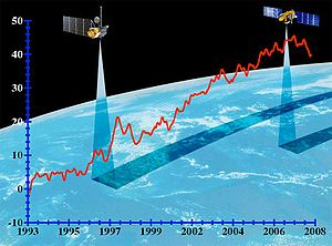
Measurements by TOPEX/Poseidon and Jason-1 show that mean sea level has been rising by about three millimeters (.12 inches) a year since 1993. This is about twice the estimates from tide gauges for the previous century, indicating a possible recent acceleration in the rate of sea level rise.
The data record from these altimetry missions has given scientists important insights into how global sea level is affected by natural climate variability, as well as by human activities.
TOPEX/Poseidon and Jason-1 data are available at the University of Colorado Center for Astrodynamics Research, NASA's Physical Oceanography Distributed Active Archive Center, and the French data archive center AVISO.
Climate Research: Altimetry data are incorporated into computer models to understand and predict changes in the distribution of heat in the ocean, a key element of climate.
El Niño & La Niña Forecasting: Understanding the pattern and effects of climate cycles such as El Niño helps predict and mitigate the disastrous effects of floods and drought.
 Hurricane Forecasting: Altimeter data and satellite ocean wind data are incorporated into atmospheric models for hurricane season forecasting and individual storm severity.
Ship Routing: Maps of ocean currents, eddies, and vector winds are used in commercial shipping and recreational yachting to optimize routes.
Offshore Industries: Cable-laying vessels and offshore oil operations require accurate knowledge of ocean circulation patterns to minimize impacts from strong currents.
Marine Mammal
Research: Sperm whales, fur seals, and other marine mammals can be tracked, and therefore studied, around ocean eddies where nutrients and plankton are abundant.
Fisheries Management: Satellite data identify ocean eddies which bring an increase in organisms that comprise the marine food web, attracting fish and fishermen.
Coral Reef
Research: Remotely sensed data are used to monitor and assess coral reef ecosystems, which are sensitive to changes in ocean temperature.
Marine Debris
Tracking: The amount of floating and partially submerged material, including nets, timber and ship debris, is increasing with human population. Altimetry can help locate these hazardous materials.
Satellite
In the context of spaceflight, a satellite is an object which has been placed into orbit by human endeavour. Such objects are sometimes called artificial satellites to distinguish them from natural satellites such as the Moon....
oceanography mission to monitor global ocean circulation, study the ties between the ocean
Ocean
An ocean is a major body of saline water, and a principal component of the hydrosphere. Approximately 71% of the Earth's surface is covered by ocean, a continuous body of water that is customarily divided into several principal oceans and smaller seas.More than half of this area is over 3,000...
and the atmosphere
Atmosphere
An atmosphere is a layer of gases that may surround a material body of sufficient mass, and that is held in place by the gravity of the body. An atmosphere may be retained for a longer duration, if the gravity is high and the atmosphere's temperature is low...
, improve global climate
Climate
Climate encompasses the statistics of temperature, humidity, atmospheric pressure, wind, rainfall, atmospheric particle count and other meteorological elemental measurements in a given region over long periods...
forecasts and predictions, and monitor events such as El Niño and ocean eddies.
It is the successor to the TOPEX/Poseidon
TOPEX/Poseidon
Launched in 1992, TOPEX/Poseidon was a joint satellite mission between NASA, the U.S. space agency, and CNES, the French space agency, to map ocean surface topography. The first major oceanographic research vessel to sail into space, TOPEX/Poseidon helped revolutionize oceanography by proving the...
mission, which measured ocean surface topography
Ocean surface topography
The ocean surface has highs and lows, similar to the hills and valleys of Earth's land surface depicted on a topographic map. These variations, called "ocean surface topography" or "dynamic sea surface topography" are mapped using measurements of sea surface height relative to Earth's geoid...
from 1992 through 2005. Like its predecessor, Jason-1 is a joint project between the NASA
NASA
The National Aeronautics and Space Administration is the agency of the United States government that is responsible for the nation's civilian space program and for aeronautics and aerospace research...
(United States
United States
The United States of America is a federal constitutional republic comprising fifty states and a federal district...
) and CNES
CNES
The is the French government space agency . Established under President Charles de Gaulle in 1961, its headquarters are located in central Paris and it is under the supervision of the French Ministries of Defence and Research...
(France
France
The French Republic , The French Republic , The French Republic , (commonly known as France , is a unitary semi-presidential republic in Western Europe with several overseas territories and islands located on other continents and in the Indian, Pacific, and Atlantic oceans. Metropolitan France...
) space agencies. Jason-1's successor, the Ocean Surface Topography Mission
Ocean Surface Topography Mission
The Ocean Surface Topography Mission on the Jason-2 satellite is an international Earth observation satellite mission that continues the sea surface height measurements begun in 1992 by the joint NASA/CNES TOPEX/Poseidon mission and followed by the NASA/CNES Jason-1 mission launched in 2001.Like...
on the Jason-2 satellite, was launched in June 2008. These satellites provide a unique global view of the oceans that is impossible to acquire using traditional ship-based sampling.
Jason-1 was built by Thales Alenia Space
Thales Alenia Space
Thales Alenia Space is an aerospace company born after the Thales Group bought the participation of Alcatel in the two joint-ventures between Alcatel and Finmeccanica, Alcatel Alenia Space and Telespazio.-History:...
using a Proteus
Proteus
In Greek mythology, Proteus is an early sea-god, one of several deities whom Homer calls the "Old Man of the Sea", whose name suggests the "first" , as protogonos is the "primordial" or the "firstborn". He became the son of Poseidon in the Olympian theogony In Greek mythology, Proteus (Πρωτεύς)...
platform, under a contract from CNES, as well as the main Jason-1 instrument, the Poseidon-2 altimeter (successor to the Poseidon altimeter on-board TOPEX/Poseidon)
Jason-1 was designed to measure climate change
Climate change
Climate change is a significant and lasting change in the statistical distribution of weather patterns over periods ranging from decades to millions of years. It may be a change in average weather conditions or the distribution of events around that average...
through very precise millimeter-per-year measurements of global sea level changes. As did TOPEX/Poseidon, Jason-1 uses an altimeter
Altimeter
An altimeter is an instrument used to measure the altitude of an object above a fixed level. The measurement of altitude is called altimetry, which is related to the term bathymetry, the measurement of depth underwater.-Pressure altimeter:...
to measure the hills and valleys of the ocean's surface. These measurements of sea surface topography
Ocean surface topography
The ocean surface has highs and lows, similar to the hills and valleys of Earth's land surface depicted on a topographic map. These variations, called "ocean surface topography" or "dynamic sea surface topography" are mapped using measurements of sea surface height relative to Earth's geoid...
allow scientists to calculate the speed and direction of ocean currents and monitor global ocean circulation. The global ocean is Earth's primary storehouse of solar energy. Jason-1's measurements of sea surface height reveal where this heat is stored, how it moves around Earth by ocean currents, and how these processes affect weather and climate.
Jason-1 was launched on December 7, 2001 from California's Vandenberg Air Force Base aboard a Delta II
Delta II
Delta II was an American space launch system, originally designed and built by McDonnell Douglas. Delta II is part of the Delta rocket family and was in service from 1989 until November 1, 2011...
rocket
Launch vehicle
In spaceflight, a launch vehicle or carrier rocket is a rocket used to carry a payload from the Earth's surface into outer space. A launch system includes the launch vehicle, the launch pad and other infrastructure....
. During the first months Jason-1 shared an almost identical orbit to TOPEX/Poseidon, which allowed for cross calibration. At the end of this period, the older satellite was moved to a new orbit midway between each Jason ground track
Ground track
A ground track or ground trace is the path on the surface of the Earth directly below an aircraft or satellite. In the case of a satellite, it is the projection of the satellite's orbit onto the surface of the Earth .A satellite ground track may be thought of as a path along the Earth's surface...
. Jason has a repeat cycle of 10 days.
Recent orbit maneuvers in 2009 put the Jason-1 satellite on the opposite side of Earth from the Jason-2 satellite, which is operated by the U.S. and French weather agencies. Jason-1 now flies over the same region of the ocean that Jason-2 flew over five days earlier. Its ground tracks fall mid-way between those of Jason-2, which are about 315 kilometres (195.7 mi) apart at the equator.
This interleaved tandem mission provides twice the number of measurements of the ocean's surface, bringing smaller features such as ocean eddies into view. The tandem mission also helps pave the way for a future ocean altimeter mission that would collect much more detailed data with its single instrument than the two Jason satellites now do together.
The program is named after the Greek
Greece
Greece , officially the Hellenic Republic , and historically Hellas or the Republic of Greece in English, is a country in southeastern Europe....
mythological hero Jason
Jason
Jason was a late ancient Greek mythological hero from the late 10th Century BC, famous as the leader of the Argonauts and their quest for the Golden Fleece. He was the son of Aeson, the rightful king of Iolcus...
.
Satellite instruments
Jason-1 has five 5 instruments:- Poseidon 2 - NadirNadirThe nadir is the direction pointing directly below a particular location; that is, it is one of two vertical directions at a specified location, orthogonal to a horizontal flat surface there. Since the concept of being below is itself somewhat vague, scientists define the nadir in more rigorous...
pointing RadarRadarRadar is an object-detection system which uses radio waves to determine the range, altitude, direction, or speed of objects. It can be used to detect aircraft, ships, spacecraft, guided missiles, motor vehicles, weather formations, and terrain. The radar dish or antenna transmits pulses of radio...
AltimeterAltimeterAn altimeter is an instrument used to measure the altitude of an object above a fixed level. The measurement of altitude is called altimetry, which is related to the term bathymetry, the measurement of depth underwater.-Pressure altimeter:...
using C bandC bandThe C band is a name given to certain portions of the electromagnetic spectrum, including wavelengths of microwaves that are used for long-distance radio telecommunications. The IEEE C-band - and its slight variations - contains frequency ranges that are used for many satellite communications...
and Ku bandKu bandThe Kμ band is a portion of the electromagnetic spectrum in the microwave range of frequencies. This symbol refers to —in other words, the band directly below the K-band...
for measuring height above seaSeaA sea generally refers to a large body of salt water, but the term is used in other contexts as well. Most commonly, it means a large expanse of saline water connected with an ocean, and is commonly used as a synonym for ocean...
surface. - Jason MicrowaveMicrowaveMicrowaves, a subset of radio waves, have wavelengths ranging from as long as one meter to as short as one millimeter, or equivalently, with frequencies between 300 MHz and 300 GHz. This broad definition includes both UHF and EHF , and various sources use different boundaries...
RadiometerRadiometerA radiometer is a device for measuring the radiant flux of electromagnetic radiation. Generally, the term radiometer denotes an infrared radiation detector, yet it also includes detectors operating on any electromagnetic wavelength....
(JMR) - measures water vaporWater vaporWater vapor or water vapour , also aqueous vapor, is the gas phase of water. It is one state of water within the hydrosphere. Water vapor can be produced from the evaporation or boiling of liquid water or from the sublimation of ice. Under typical atmospheric conditions, water vapor is continuously...
along altimeter path to correct for pulse delay - DORISDORIS (geodesy)Doppler Orbitography and Radiopositioning Integrated by Satellite is a French satellite system used for the determination of satellite orbits and for positioning.-Principle:...
(DopplerDoppler effectThe Doppler effect , named after Austrian physicist Christian Doppler who proposed it in 1842 in Prague, is the change in frequency of a wave for an observer moving relative to the source of the wave. It is commonly heard when a vehicle sounding a siren or horn approaches, passes, and recedes from...
Orbitography and Radiopositioning Integrated by SatelliteSatelliteIn the context of spaceflight, a satellite is an object which has been placed into orbit by human endeavour. Such objects are sometimes called artificial satellites to distinguish them from natural satellites such as the Moon....
) for orbit determination to within 10 cm or less and ionosphericIonosphereThe ionosphere is a part of the upper atmosphere, comprising portions of the mesosphere, thermosphere and exosphere, distinguished because it is ionized by solar radiation. It plays an important part in atmospheric electricity and forms the inner edge of the magnetosphere...
correction data for Poseidon 2. - BlackJack Global Positioning SystemGlobal Positioning SystemThe Global Positioning System is a space-based global navigation satellite system that provides location and time information in all weather, anywhere on or near the Earth, where there is an unobstructed line of sight to four or more GPS satellites...
receiver provides precise orbitOrbitIn physics, an orbit is the gravitationally curved path of an object around a point in space, for example the orbit of a planet around the center of a star system, such as the Solar System...
ephemerisEphemerisAn ephemeris is a table of values that gives the positions of astronomical objects in the sky at a given time or times. Different kinds of ephemerides are used for astronomy and astrology...
data - Laser retroreflectorRetroreflectorA retroreflector is a device or surface that reflects light back to its source with a minimum scattering of light. An electromagnetic wave front is reflected back along a vector that is parallel to but opposite in direction from the wave's source. The device or surface's angle of incidence is...
array works with ground stations to track the satellite and calibrate and verify altimeter measurements.
The Jason-1 satellite, its altimeter instrument and a position-tracking antenna were built in France. The radiometer, Global Positioning System receiver and laser retroreflector array were built in the United States.
Use of information
TOPEX/PoseidonTOPEX/Poseidon
Launched in 1992, TOPEX/Poseidon was a joint satellite mission between NASA, the U.S. space agency, and CNES, the French space agency, to map ocean surface topography. The first major oceanographic research vessel to sail into space, TOPEX/Poseidon helped revolutionize oceanography by proving the...
and Jason-1 have led to major advances in the science of physical oceanography
Physical oceanography
Physical oceanography is the study of physical conditions and physical processes within the ocean, especially the motions and physical properties of ocean waters.Physical oceanography is one of several sub-domains into which oceanography is divided...
and in climate studies. Their 15-year data record of ocean surface topography has provided the first opportunity to observe and understand the global change of ocean circulation and sea level. The results have improved the understanding of the role of the ocean in climate change and improved weather and climate predictions. Data from these missions are used to improve ocean models, forecast hurricane intensity, and identify and track large ocean/atmosphere phenomena such as El Niño and La Niña. The data are also used every day in applications as diverse as routing ships, improving the safety and efficiency of offshore industry operations, managing fisheries, and tracking marine mammals.
TOPEX/Poseidon and Jason 1-have made major contributions to the understanding of:
Ocean Variability
The missions revealed the surprising variability of the ocean, how much it changes from season to season, year to year, decade to decade and on even longer time scales. They ended the traditional notion of a quasi-steady, large-scale pattern of global ocean circulation by proving that the ocean is changing rapidly on all scales, from huge features such as El Niño and La Niña, which can cover the entire equatorial Pacific, to tiny eddies swirling off the large Gulf Stream in the Atlantic.Sea Level ChangeSea levelMean sea level is a measure of the average height of the ocean's surface ; used as a standard in reckoning land elevation...
Measurements by TOPEX/Poseidon and Jason-1 show that mean sea level has been rising by about three millimeters (.12 inches) a year since 1993. This is about twice the estimates from tide gauges for the previous century, indicating a possible recent acceleration in the rate of sea level rise.The data record from these altimetry missions has given scientists important insights into how global sea level is affected by natural climate variability, as well as by human activities.
Planetary Waves
TOPEX/Poseidon and Jason-1 made clear the importance of planetary-scale waves, such as Rossby and Kelvin waves. No one had realized how widespread these waves are. Thousands of kilometers wide, these waves are driven by wind under the influence of Earth’s rotation and are important mechanisms for transmitting climate signals across the large ocean basins. At high latitudes, they travel twice as fast as scientists believed previously, showing the ocean responds much more quickly to climate changes than was known before these missions.Ocean Tides
The precise measurements of TOPEX/Poseidon’s and Jason-1 have brought knowledge of ocean tides to an unprecedented level. The change of water level due to tidal motion in the deep ocean is known everywhere on the globe to within 2.5 centimeters (one inch). This new knowl¬edge has revised notions about how tides dissipate. Instead of losing all their energy over shallow seas near the coasts, as previously believed, about one third of tidal energy is actually lost to the deep ocean. There, the energy is consumed by mixing water of different properties, a fundamental mechanism in the physics governing the general circulation of the ocean.Ocean Models
TOPEX/Poseidon and Jason-1 observations provided the first global data for improving the performance of the numerical ocean models that are a key component of climate prediction models.TOPEX/Poseidon and Jason-1 data are available at the University of Colorado Center for Astrodynamics Research, NASA's Physical Oceanography Distributed Active Archive Center, and the French data archive center AVISO.
Benefits to society
Altimetry data have a wide variety of uses from basic scientific research on climate to ship routing. Applications include:Climate Research: Altimetry data are incorporated into computer models to understand and predict changes in the distribution of heat in the ocean, a key element of climate.
El Niño & La Niña Forecasting: Understanding the pattern and effects of climate cycles such as El Niño helps predict and mitigate the disastrous effects of floods and drought.
Ship Routing: Maps of ocean currents, eddies, and vector winds are used in commercial shipping and recreational yachting to optimize routes.
Offshore Industries: Cable-laying vessels and offshore oil operations require accurate knowledge of ocean circulation patterns to minimize impacts from strong currents.
Marine Mammal
Marine mammal
Marine mammals, which include seals, whales, dolphins, and walruses, form a diverse group of 128 species that rely on the ocean for their existence. They do not represent a distinct biological grouping, but rather are unified by their reliance on the marine environment for feeding. The level of...
Research: Sperm whales, fur seals, and other marine mammals can be tracked, and therefore studied, around ocean eddies where nutrients and plankton are abundant.
Fisheries Management: Satellite data identify ocean eddies which bring an increase in organisms that comprise the marine food web, attracting fish and fishermen.
Coral Reef
Coral reef
Coral reefs are underwater structures made from calcium carbonate secreted by corals. Coral reefs are colonies of tiny living animals found in marine waters that contain few nutrients. Most coral reefs are built from stony corals, which in turn consist of polyps that cluster in groups. The polyps...
Research: Remotely sensed data are used to monitor and assess coral reef ecosystems, which are sensitive to changes in ocean temperature.
Marine Debris
Marine debris
Marine debris, also known as marine litter, is human created waste that has deliberately or accidentally become afloat in a lake, sea, ocean or waterway. Oceanic debris tends to accumulate at the centre of gyres and on coastlines, frequently washing aground, when it is known as beach litter or...
Tracking: The amount of floating and partially submerged material, including nets, timber and ship debris, is increasing with human population. Altimetry can help locate these hazardous materials.
See also
- ArgoArgo (oceanography)Argo is an observation system for the Earth's oceans that provides real-time data for use in climate, weather, oceanographic and fisheries research. Argo consists of a large collection of small, drifting oceanic robotic probes deployed worldwide. The probes float as deep as 2 km. Once every...
, a project to measure the temperature and salinitySalinitySalinity is the saltiness or dissolved salt content of a body of water. It is a general term used to describe the levels of different salts such as sodium chloride, magnesium and calcium sulfates, and bicarbonates...
of the upper 2 km of the water column. - SeasatSeasatSEASAT was the first Earth-orbiting satellite designed for remote sensing of the Earth's oceans and had on board the first spaceborne synthetic aperture radar . The mission was designed to demonstrate the feasibility of global satellite monitoring of oceanographic phenomena and to help determine...
- an early radar altimeter satellite - TOPEX/PoseidonTOPEX/PoseidonLaunched in 1992, TOPEX/Poseidon was a joint satellite mission between NASA, the U.S. space agency, and CNES, the French space agency, to map ocean surface topography. The first major oceanographic research vessel to sail into space, TOPEX/Poseidon helped revolutionize oceanography by proving the...
- the immediate predecessor to Jason-1. - Ocean Surface Topography Mission/Jason-2 - the immediate successor to Jason-1.
- 2004 Indian Ocean earthquake (Energy of the earthquake)