
January 1999 tornado outbreak sequence
Encyclopedia
The January 1999 tornado outbreak sequence was a major outbreak of tornado
es from January 17 to 22 1999 across the Mississippi Valley, USA, centered in Arkansas
and Tennessee
. It was (and remains) by far the largest tornado outbreak
ever recorded in the month of January with 150 tornadoes confirmed. 17 people were killed by the tornadoes.
Jackson, Tennessee
was hit by two devastating tornadoes on the evening of January 17. The first tornado began south of Eurekaton in Haywood County at about 6:15 pm CST
(0015 UTC) and tracked across rural areas towards the Madison County line. In Haywood County, there were 12 houses destroyed along with several farm buildings. The damage picked up more as it passed through Mercer and Denmark, where several more houses were destroyed. Severe damage was also reported at the McKellar-Sipes Regional Airport
where several buildings were flattened and equipment was destroyed. The tornado crossed into the north side of Jackson, where severe damage was reported to 38 houses and apartments; most of which were destroyed. The first tornado dissipated at about 6:25 pm CST (0025 UTC). Two people were injured by the first tornado, which was rated as an F3 on the Fujita scale
.
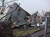
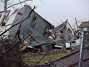
The second tornado developed east of Bemis at 6:25 pm when the first tornado dissipated. The tornado crossed into the southern part of Jackson, severely damaging the city. Over 200 homes and numerous businesses were destroyed or flattened and hundreds of others were damaged. Some of the demolished buildings include portions of a shopping center, the athletic fields of a high school, a school bus garage, half of an apartment building and a funeral home. Six people were killed and 106 were injured by this tornado, which was rated F4.
 The Little Rock
area was slammed by a strong tornado on the evening of January 21. It tracked directly into the downtown area, making it one of the few tornadoes in recent years to directly hit the downtown area of a major city.
The tornado began in Saline County south of Vimy Ridge at 6:24 pm CST (0024 UTC). Before crossing the Pulaski County line, it did moderate damage to several houses and significant damage to a mobile home. It crossed into Pulaski County at 6:33 pm, where moderate roof damage was reported to several buildings along the Interstate 30
corridor. It continued eastward and did most of its devastation in the downtown area.
The downtown area was devastated. There was severe damage reported to over 235 buildings, many of which were destroyed. One of the destroyed buildings included a large grocery store
, a Harvest Foods, where one person was killed. Over 500 other buildings sustained lesser damage. Some of the houses damaged that were in the historic district were also condemned due to there being lead smelt beneath them. Trees and power lines were also knocked down throughout the area. Damage was also reported on the property of the Arkansas Governor's Mansion
, where many trees were knocked down. As the tornado left downtown, it weakened as it crossed Interstate 40
. It weakened in the northeastern suburbs, near Sherwood
at 6:53 pm CST, after being on the ground for 29 minutes and travelling 22 miles (35 km). The first tornado was rated as an F3 tornado on the Fujita scale
As the first tornado dissipated, a second tornado developed in eastern Pulaski County. While it remained in more rural settings, it also destroyed several buildings, including a storage facility. It also knocked over several tractor trailers before crossing into Lonoke County. Extensive damage was also reported in Lonoke County, where the South Bend community was hit hard. 12 houses, 11 mobile homes and several farm buildings were damaged or destroyed in Lonoke County. The tornado dissipated at 7:02 pm CST (0102 UTC) southwest of Cabot
. It was an F2 tornado.
Three people died in the tornadoes. One of them was in the destroyed grocery store, another was in a vehicle hit by a tree, and the third was in a mobile home that was destroyed. 78 other people were injured by the tornado.
Tornado
A tornado is a violent, dangerous, rotating column of air that is in contact with both the surface of the earth and a cumulonimbus cloud or, in rare cases, the base of a cumulus cloud. They are often referred to as a twister or a cyclone, although the word cyclone is used in meteorology in a wider...
es from January 17 to 22 1999 across the Mississippi Valley, USA, centered in Arkansas
Arkansas
Arkansas is a state located in the southern region of the United States. Its name is an Algonquian name of the Quapaw Indians. Arkansas shares borders with six states , and its eastern border is largely defined by the Mississippi River...
and Tennessee
Tennessee
Tennessee is a U.S. state located in the Southeastern United States. It has a population of 6,346,105, making it the nation's 17th-largest state by population, and covers , making it the 36th-largest by total land area...
. It was (and remains) by far the largest tornado outbreak
Tornado outbreak
While there is no single agreed upon definition, generally at least 6-10 tornadoes produced by the same synoptic scale weather system is considered a tornado outbreak. The tornadoes usually occur within the same day, or continue into the early morning hours of the succeeding day, and within the...
ever recorded in the month of January with 150 tornadoes confirmed. 17 people were killed by the tornadoes.
January 17 event
| F# Fujita scale The Fujita scale , or Fujita-Pearson scale, is a scale for rating tornado intensity, based primarily on the damage tornadoes inflict on human-built structures and vegetation... |
Location | County | Time (UTC) | Path length | Damage | |
|---|---|---|---|---|---|---|
| Arkansas Arkansas Arkansas is a state located in the southern region of the United States. Its name is an Algonquian name of the Quapaw Indians. Arkansas shares borders with six states , and its eastern border is largely defined by the Mississippi River... |
||||||
| F2 | SE of Oil Trough Oil Trough, Arkansas Oil Trough is a town in Independence County, Arkansas, United States. The population was 218 at the 2000 census. The town is believed to have acquired its name in the early 19th century from a trough used to render bear fat, which was sold to customers in New Orleans... |
Independence, Jackson | 2051 | 7 miles (11 km) |
First tornado of the outbreak. Heavy damage to at least one house, plus extensive tree and power line damage. | |
| F1 | Diaz Diaz, Arkansas Diaz is a city in Jackson County, Arkansas, United States. The population was 1,284 at the 2000 census.-Geography:Diaz is located at .... (1st tornado) |
Jackson | 2106 | 2 miles (3.2 km) |
Damage mostly to trees. | |
| F0 | Diaz Diaz, Arkansas Diaz is a city in Jackson County, Arkansas, United States. The population was 1,284 at the 2000 census.-Geography:Diaz is located at .... (2nd tornado) |
Jackson | 2108 | unknown | Weak, short-lived tornado with no damage. | |
| F1 | Tuckerman Tuckerman, Arkansas Tuckerman is a city in Jackson County, Arkansas, USA. The population was 1,757 at the 2000 census.Each year on the second weekend of May, Tuckerman hosts Hometown Days, a festival for the town and fundraiser for the Tuckerman Fire Department.-Geography:... area |
Jackson | 2123 | 9 miles (15 km) |
Significant damage reported in a residential subdivision and at a sewer Sanitary sewer A sanitary sewer is a separate underground carriage system specifically for transporting sewage from houses and commercial buildings to treatment or disposal. Sanitary sewers serving industrial areas also carry industrial wastewater... plant. One person was injured. |
|
| F0 | NE of Tuckerman Tuckerman, Arkansas Tuckerman is a city in Jackson County, Arkansas, USA. The population was 1,757 at the 2000 census.Each year on the second weekend of May, Tuckerman hosts Hometown Days, a festival for the town and fundraiser for the Tuckerman Fire Department.-Geography:... |
Jackson | 2128 | 1 mile (1.6 km) |
Weak tornado with damage limited to trees. | |
| F1 | Grubbs Grubbs, Arkansas Grubbs is a town in Jackson County, Arkansas, United States. The population was 438 at the 2000 census.-Geography:Grubbs is located at .According to the United States Census Bureau, the town has a total area of 1.4 km² , all land.... area |
Jackson | 2128 | 6 miles (9.6 km) |
Damage reported to about 12 houses, with a mobile home Mobile home Mobile homes or static caravans are prefabricated homes built in factories, rather than on site, and then taken to the place where they will be occupied... destroyed. Several barns were also damaged. |
|
| F0 | N of Grubbs Grubbs, Arkansas Grubbs is a town in Jackson County, Arkansas, United States. The population was 438 at the 2000 census.-Geography:Grubbs is located at .According to the United States Census Bureau, the town has a total area of 1.4 km² , all land.... |
Jackson | 2138 | unknown | Brief tornado with only minor tree damage. | |
| F0 | Risher area | Craighead Craighead County, Arkansas Craighead County is a county located in the U.S. state of Arkansas. As of the 2010 census, the population was 96,443. It is included in the Jonesboro, Arkansas Metropolitan Statistical Area. Craighead County is Arkansas's 58th county, formed on February 19, 1859, and named for state Senator Thomas... |
2145 | 16 miles (26 km) |
Weak, long-tracked tornado. Damage limited to trees and power lines along its path. | |
| F0 | E of Lafe Lafe, Arkansas Lafe is a town in Greene County, Arkansas on Crowley's Ridge. The population was 385 at the 2000 census.- History :The first settler of Lafe was Mr. Herman Toelken, a German immigrant who had been living in New Haven, Missouri and was seeking new opportunities in an unsettled area... |
Greene | 2230 | 8 miles (13 km) |
Minor tree damage along the path. | |
| F1 | Schug area | Greene | 2235 | 6 miles (9.6 km) |
Several mobile homes damaged. A substance abuse Substance abuse A substance-related disorder is an umbrella term used to describe several different conditions associated with several different substances .A substance related disorder is a condition in which an individual uses or abuses a... center lost its roof. |
|
| F0 | NW of Weiner Weiner, Arkansas Weiner is a city in Poinsett County, Arkansas, United States. The population was 760 at the 2000 census. It is included in the Jonesboro, Arkansas Metropolitan Statistical Area.-Geography:Weiner is located at .... |
Poinsett | 2245 | 8 miles (13 km) |
Tornado remained north of town. Minor damage reported. | |
| F2 | Lake City Lake City, Arkansas Lake City is a town in Craighead County, Arkansas in the United States, along the St. Francis River. The population is 2,082 according to the 2010 census. It is included in the Jonesboro, Arkansas Metropolitan Statistical Area... area |
Craighead Craighead County, Arkansas Craighead County is a county located in the U.S. state of Arkansas. As of the 2010 census, the population was 96,443. It is included in the Jonesboro, Arkansas Metropolitan Statistical Area. Craighead County is Arkansas's 58th county, formed on February 19, 1859, and named for state Senator Thomas... |
2145 | 11 miles (17 km) |
Two houses were destroyed and five others damage. Severe damage to an electrical substation Electrical substation A substation is a part of an electrical generation, transmission, and distribution system. Substations transform voltage from high to low, or the reverse, or perform any of several other important functions... . |
|
| Tennessee Tennessee Tennessee is a U.S. state located in the Southeastern United States. It has a population of 6,346,105, making it the nation's 17th-largest state by population, and covers , making it the 36th-largest by total land area... |
||||||
| F2 | Halls Halls, Tennessee Halls is a town in Lauderdale County, Tennessee, United States. The population was 2,311 at the 2000 census.The town was founded in 1882. It is named after Hansford R. Hall, one of the founders... area |
Lauderdale | 2355 | 4 miles (6.4 km) |
Severe damage reported in Halls. Two businesses were flattened along with several mobile homes. Major damage to a church as well. In total, 49 structures were damaged or destroyed and 11 people were injured. | |
| F3 | Alamo Alamo, Tennessee Alamo, Tennessee, is a town in Crockett County, Tennessee. Its population was 2,461 at the time of the 2010 U.S. Census. Alamo, for interesting historical reasons, is the county seat of Crockett County, Tennessee... area |
Crockett | 0009 | 10 miles (16 km) |
Heavy damage in the south side of Alamo. 16 houses (including several mobile homes) and one business were destroyed and 73 others were damaged. Four people were injured. | |
| F3 | Jackson Jackson, Tennessee Jackson is a city in Madison County, Tennessee, United States. The total population was 65,211 at the 2010 census. Jackson is the primary city of the Jackson, Tennessee metropolitan area, which is included in the Jackson-Humboldt, Tennessee Combined Statistical Area... area (1st tornado) |
Haywood, Madison | 0015 | 22 miles (35 km) |
See section on this tornado | |
| F4 | Jackson Jackson, Tennessee Jackson is a city in Madison County, Tennessee, United States. The total population was 65,211 at the 2010 census. Jackson is the primary city of the Jackson, Tennessee metropolitan area, which is included in the Jackson-Humboldt, Tennessee Combined Statistical Area... area (2nd tornado) |
Madison | 0025 | 16 miles (26 km) |
6 deaths - See section on this tornado | |
| F1 | Saulsbury Saulsbury, Tennessee Saulsbury is a town in Hardeman County, Tennessee, United States. The population was 99 at the 2000 census. It is located along State Highway 57 in southwest Hardeman County.-History:... area |
Fayette, Hardeman | 0035 | 12 miles (20 km) |
1 death - 1/4 mile (400 m) wide tornado destroyed 14 houses (most of them mobile homes) and damaged 27 others. Extensive tree and power line damage also reported. Four others were injured. | |
| F1 | Atwood Atwood, Tennessee Atwood is a town in Carroll County, Tennessee, United States. The population was 938 at the 2010 census.-Geography:According to the United States Census Bureau, the town has a total area of , all of it land.-Demographics:... area |
Carroll Carroll County, Tennessee Carroll County is a county located in the U.S. state of Tennessee. As of 2010, the population was 28,522. Its county seat is Huntingdon. It was named for Governor William Carroll.-Geography:According to the U.S... |
0105 | 10 miles (16 km) |
1 death - Four mobile homes were destroyed and eight others were damaged. Numerous trees and power lines were damaged. One other person was injured. | |
| F1 | W of Dover Dover, Tennessee Dover is a city in Stewart County, Tennessee, United States, westnorthwest of Nashville on the Cumberland River. An old national cemetery is in Dover. The population was 1,442 at the 2000 census... |
Stewart | 0106 | unknown | Short-lived tornado damaged the roof of a grocery store. | |
| F1 | E of Woodlawn Woodlawn, Tennessee Woodlawn is an unincorporated community in Montgomery County, Tennessee, United States. It is located along State Route 79 west of neighboring Clarksville. The community has a post office with the ZIP Code of 37191.... |
Montgomery Montgomery County, Tennessee Montgomery County is a county located in the U.S. state of Tennessee. The county seat is Clarksville. The population was 172,331 at the 2010 census. It is one of the four counties included in the Clarksville, TN–KY Metropolitan Statistical Area.... |
0128 | 1 mile (1.6 km) |
Damage was reported on several farms, with several barns destroyed. | |
| F1 | SE of Adams Adams, Tennessee Adams is a city in Robertson County, Tennessee, United States. The population was 633 at the 2010 census.-History:Originally incorporated as Red River in 1869, the town was renamed Adams in 1898 in honor of James Reuben Adams, who first owned much of the land on which the town was built. The town's... |
Robertson | 0200 | 1 mile (1.6 km) |
One farm was damaged, with moderate damage to the house and the barn and greenhouse destroyed. | |
| Mississippi Mississippi Mississippi is a U.S. state located in the Southern United States. Jackson is the state capital and largest city. The name of the state derives from the Mississippi River, which flows along its western boundary, whose name comes from the Ojibwe word misi-ziibi... |
||||||
| F0 | Slayden Slayden, Mississippi Slayden is an unincorporated community located in Marshall County, Mississippi, United States. It is located along U. S. Route 72 on the Northeast side of Marshall County. Although Slayden is unincorporated, it shares a ZIP code of 38642 with Lamar, Mississippi..... |
Marshall Marshall County, Mississippi -Demographics:At the 2000 census, there were 34,993 people, 12,163 households and 9,110 families residing in the county. The population density was 50 per square mile . There were 13,252 housing units at an average density of 19 per square mile... |
0045 | 1 mile (1.6 km) |
Two mobile homes were destroyed and a house under construction was flattened. Two people were injured. | |
| Sources: National Climatic Data Center | ||||||
January 21 event
| F# Fujita scale The Fujita scale , or Fujita-Pearson scale, is a scale for rating tornado intensity, based primarily on the damage tornadoes inflict on human-built structures and vegetation... |
Location | County | Time (UTC) | Path length | Damage | |
|---|---|---|---|---|---|---|
| Arkansas Arkansas Arkansas is a state located in the southern region of the United States. Its name is an Algonquian name of the Quapaw Indians. Arkansas shares borders with six states , and its eastern border is largely defined by the Mississippi River... |
||||||
| F1 | S of Lerch | Lafayette | 2110 | 9 miles (15 km) |
Little damage reported, primarily to trees. | |
| F0 | N of Cornelius | Lafayette | 2133 | 1 mile (1.6 km) |
Tornado remained in woodlands, blocked roads but no buildings damaged. | |
| F0 | NE of Lerch | Lafayette | 2138 | 1 mile (1.6 km) |
Tornado remained in woodlands. No damage. | |
| F0 | S of Genoa Genoa, Arkansas Genoa is an unincorporated community in Miller County, Arkansas, United States. It is located east of Texarkana along Highway 196. Although it is unincorporated, it has a post office, with the ZIP code of 71840.... |
Miller | 2145 | 4 miles (6.4 km) |
Tornado track remained in unpopulated farmlands. | |
| F2 | SE of Naylor | Faulkner, White White County, Arkansas White County is a county located in the U.S. state of Arkansas. As of 2010, the population was 77,076. The county seat is Searcy. White County is Arkansas's 31st county, formed on October 23, 1835, from portions of Independence, Jackson, and Pulaski counties and named for Hugh Lawson White, a... |
2157 | 10 miles (16 km) |
Two manufactured homes were destroyed, along with two hay barns. The roof of a church was also damaged. Seven people were injured. | |
| F1 | S of Princeton Princeton, Arkansas Princeton is an unincorporated community in Dallas County, Arkansas, United States. Princeton is located at the junction of Arkansas Highway 8 and Arkansas Highway 9 southwest of Carthage. Princeton Cemetery, which is listed on the National Register of Historic Places, is located in the community.... (1st tornado) |
Dallas | 2229 | 7 miles (11 km) |
Damage limited to many trees along its path. | |
| F3 | S of Princeton Princeton, Arkansas Princeton is an unincorporated community in Dallas County, Arkansas, United States. Princeton is located at the junction of Arkansas Highway 8 and Arkansas Highway 9 southwest of Carthage. Princeton Cemetery, which is listed on the National Register of Historic Places, is located in the community.... (2nd tornado) |
Dallas | 2229 | 11 miles (17 km) |
Powerful and large tornado remained over rural areas, however, it obliterated a 1/4 mile (400 m) swath of trees along its path. | |
| F1 | Evening Star | Greene | 2230 | 11 miles (17 km) |
12 houses were damaged or destroyed. A church was also heavily damaged. | |
| F0 | Hickory Ridge Hickory Ridge, Arkansas Hickory Ridge is a city in Cross County, Arkansas, United States. The population was 384 at the 2000 census.-Geography:Hickory Ridge is located at .... |
Cross | 2233 | unknown | Brief touchdown with no damage, but hundreds of geese Goose The word goose is the English name for a group of waterfowl, belonging to the family Anatidae. This family also includes swans, most of which are larger than true geese, and ducks, which are smaller.... killed. |
|
| F3 | Sunnydale area | White White County, Arkansas White County is a county located in the U.S. state of Arkansas. As of 2010, the population was 77,076. The county seat is Searcy. White County is Arkansas's 31st county, formed on October 23, 1835, from portions of Independence, Jackson, and Pulaski counties and named for Hugh Lawson White, a... , Independence |
2238 | 19 miles (31 km) |
Strong tornado up to 1/2 mile (800 m) wide damaged or destroyed many houses, including several flattened trailers. Extensive damage also to trees. Two people were injured. | |
| F0 | E of Knobel Knobel, Arkansas Knobel is a town in Clay County, Arkansas, United States. The population was 358 at the 2000 census.-Geography:Knobel is located at .... (1st tornado) |
Clay Clay County, Arkansas Clay County is a county located in the U.S. state of Arkansas. As of 2010, the population was 16,083. The county has two county seats, Corning and Piggott... |
2245 | 12 miles (20 km) |
Minor damage reported to one house. | |
| F2 | Center Hill area | White White County, Arkansas White County is a county located in the U.S. state of Arkansas. As of 2010, the population was 77,076. The county seat is Searcy. White County is Arkansas's 31st county, formed on October 23, 1835, from portions of Independence, Jackson, and Pulaski counties and named for Hugh Lawson White, a... |
2246 | 8 miles (13 km) |
2 deaths - Tornado followed the Highway 305 corridor. Several mobile homes were thrown and destroyed, killing two occupants. Many other houses were damaged. Two others were injured. | |
| F1 | NE of Macon | Pulaski, Faulkner, Lonoke, White White County, Arkansas White County is a county located in the U.S. state of Arkansas. As of 2010, the population was 77,076. The county seat is Searcy. White County is Arkansas's 31st county, formed on October 23, 1835, from portions of Independence, Jackson, and Pulaski counties and named for Hugh Lawson White, a... |
2249 | 8 miles (13 km) |
One house suffered a damaged roof and a mobile home was damaged. Extensive tree damage along the path. | |
| F2 | Oil Trough Oil Trough, Arkansas Oil Trough is a town in Independence County, Arkansas, United States. The population was 218 at the 2000 census. The town is believed to have acquired its name in the early 19th century from a trough used to render bear fat, which was sold to customers in New Orleans... area |
Independence | 2255 | 20 miles (32 km) |
Several houses were damaged or destroyed, along with numerous outbuildings. Widespread damage to trees and power lines. Three people were injured. | |
| F3 | S of Brinkley Brinkley, Arkansas Brinkley is the most populous city in Monroe County, Arkansas, United States. The population was 3,940 at the 2000 census.It is located almost exactly half-way between Little Rock, Arkansas and Memphis, Tennessee; the city has used the slogan "We'll Meet You Half-Way" in some of its advertising... |
Monroe Monroe County, Arkansas Monroe County is a county located in the U.S. state of Arkansas. As of 2010, the population is 8,149. The county seat is Clarendon, while its largest city is Brinkley... , St. Francis |
2302 | 36 miles (57 km) |
Long-track tornado flattened one house and destroyed 20 others along its path, plus numerous farm buildings and outbuildings. Several transmission towers were knocked down. Nine people were injured. | |
| F4 | E of Knobel Knobel, Arkansas Knobel is a town in Clay County, Arkansas, United States. The population was 358 at the 2000 census.-Geography:Knobel is located at .... (2nd tornado) |
Clay Clay County, Arkansas Clay County is a county located in the U.S. state of Arkansas. As of 2010, the population was 16,083. The county has two county seats, Corning and Piggott... |
2305 | 16 miles (26 km) |
Violent tornado flattened two houses and damaged several others along its path. Two tractor trailers were destroyed. | |
| F1 | Whitehall Whitehall, Arkansas Whitehall is the name of some places in the State of Arkansas in the United States of America:* Whitehall, Lee County, Arkansas* Whitehall, Poinsett County, Arkansas* Whitehall, Yell County, Arkansas... area |
Jefferson Jefferson County, Arkansas Jefferson County is a county located in the U.S. state of Arkansas. Its population was 77,435 at the 2010 United States Census. It is included in the Pine Bluff Metropolitan Statistical Area. Jefferson County's county seat and largest city is Pine Bluff... |
2311 | 14 miles (23 km) |
Several houses damaged and barns destroyed before tracking into the Pine Bluff Arsenal Pine Bluff Arsenal The Pine Bluff Arsenal is a US Army installation located in Jefferson County, Arkansas, just northwest of the city of Pine Bluff. PBA is one of the six Army installations in the United States that store chemical weapons... . Several buildings were damaged on the Arsenal, primarily to roofs. After crossing the Arkansas River Arkansas River The Arkansas River is a major tributary of the Mississippi River. The Arkansas generally flows to the east and southeast as it traverses the U.S. states of Colorado, Kansas, Oklahoma, and Arkansas. The river's initial basin starts in the Western United States in Colorado, specifically the Arkansas... , several more houses damaged. Four people were injured. |
|
| F0 | Garret Grove | Lee | 2325 | unknown | Brief touchdown with minimal damage. | |
| F0 | Goodwin Goodwin, Arkansas Goodwin is an unincorporated community in St. Francis County, Arkansas, United States. Goodwin is located along U.S. Route 70 east-northeast of Wheatley. Goodwin has a post office with ZIP code 72340.... |
St. Francis | 2325 | unknown | Brief touchdown in town. Some minor damage reported. | |
| F1 | E of Tucker Tucker, Arkansas Tucker is an unincorporated area in Jefferson County, Arkansas. It has an elevation of 226 ft .-History:In 1871 John Woodfin Tucker established the Tucker Plantation, named after his wife, Sarah E. Tucker. The plantation, which mostly produced cotton, expanded to occupy . Paid farmworkers and... |
Jefferson Jefferson County, Arkansas Jefferson County is a county located in the U.S. state of Arkansas. Its population was 77,435 at the 2010 United States Census. It is included in the Pine Bluff Metropolitan Statistical Area. Jefferson County's county seat and largest city is Pine Bluff... , Lonoke |
2330 | 16 miles (26 km) |
Several buildings damaged on the grounds of the Arkansas State Penitentary. Significant tree damage along the path. | |
| F1 | S of Donaldson Donaldson, Arkansas Donaldson is a town in Hot Spring County, Arkansas, United States. The population was 326 at the 2000 census.-Geography:Donaldson is located at .According to the United States Census Bureau, the town has a total area of , all land.... |
Hot Spring | 2334 | 2 miles (3.2 km) |
Minimal damage, mostly to trees. | |
| F1 | SE of Donaldson Donaldson, Arkansas Donaldson is a town in Hot Spring County, Arkansas, United States. The population was 326 at the 2000 census.-Geography:Donaldson is located at .According to the United States Census Bureau, the town has a total area of , all land.... |
Hot Spring | 2337 | 4 miles (6.4 km) |
Formed as the previous tornado dissipated. No significant damage. | |
| F1 | S of Romance Romance, Arkansas Romance, Arkansas is an unincorporated community in west-central White County, Arkansas. The community is located approximately halfway between the town of Rose Bud to the north, and the unincorporated community of El Paso to the south... |
White White County, Arkansas White County is a county located in the U.S. state of Arkansas. As of 2010, the population was 77,076. The county seat is Searcy. White County is Arkansas's 31st county, formed on October 23, 1835, from portions of Independence, Jackson, and Pulaski counties and named for Hugh Lawson White, a... |
2338 | 1 mile (1.6 km) |
Several houses suffered minor roof damage. | |
| F2 | Joy area | White White County, Arkansas White County is a county located in the U.S. state of Arkansas. As of 2010, the population was 77,076. The county seat is Searcy. White County is Arkansas's 31st county, formed on October 23, 1835, from portions of Independence, Jackson, and Pulaski counties and named for Hugh Lawson White, a... |
2347 | 10 mile (16 km) |
Several buildings were damaged, including an antique store and a fire department Fire department A fire department or fire brigade is a public or private organization that provides fire protection for a certain jurisdiction, which typically is a municipality, county, or fire protection district... building. Several outbuildings were destroyed. Extensive tree damage was reported. |
|
| F0 | W of Hoxie Hoxie, Arkansas Hoxie is a city in Lawrence County, Arkansas, United States. The population was 2,817 at the 2000 census. Hoxie lies immediately south of Walnut Ridge.-Geography:Hoxie is located at .... |
Lawrence | 0000 | unknown | Short-lived tornado with minimal damage. | |
| F3 | NE of Oil Trough Oil Trough, Arkansas Oil Trough is a town in Independence County, Arkansas, United States. The population was 218 at the 2000 census. The town is believed to have acquired its name in the early 19th century from a trough used to render bear fat, which was sold to customers in New Orleans... |
Independence, Jackson, Lawrence | 0005 | 39 miles (62 km) |
Powerful tornado remained in rural areas. Extensive and severe damage to trees with swaths of forests up to 1/2 mile wide obliterated. | |
| F2 | W of Hazen Hazen, Arkansas Hazen is a city in Prairie County, Arkansas, United States. The population was 1,637 at the 2000 census.-Geography:Hazen is located at .... |
Prairie | 0013 | 7 miles (11 km) |
One house was destroyed and several others suffered varying degrees of damage. | |
| F0 | W of Colt Colt, Arkansas Colt is a city in St. Francis County, Arkansas, United States. The population was 368 at the 2000 census. It was the birthplace of country singer Charlie Rich.-Geography:Colt is located at .... |
St. Francis | 0015 | unknown | Brief tornado with minimal damage. | |
| F3 | SE of Malvern Malvern, Arkansas Malvern is the county seat of Hot Spring County, Arkansas. The city had a population of 10,318 at the time of the 2010 census and is also called the "Brick Capital of the World" because of the three Acme Brick plants in the area... |
Hot Spring, Grant | 0018 | 11 miles (17 km) |
Tornado remained in mostly rural areas with extensive damage to trees. One chicken house was destroyed. | |
| F2 | Pleasant Plains Pleasant Plains, Arkansas Pleasant Plains is a town in Independence County, Arkansas, United States. The population was 267 at the 2000 census.-Geography:Pleasant Plains is located at .... area |
White White County, Arkansas White County is a county located in the U.S. state of Arkansas. As of 2010, the population was 77,076. The county seat is Searcy. White County is Arkansas's 31st county, formed on October 23, 1835, from portions of Independence, Jackson, and Pulaski counties and named for Hugh Lawson White, a... , Independence |
0020 | 11 miles (17 km) |
1 death - At least 30 houses, several businesses, a church and several barns were damaged, and a trailer was destroyed - killing an occupant. | |
| F1 | Des Arc Des Arc, Arkansas Des Arc is a city in and the county seat of the northern district of Prairie County, Arkansas, United States. The population was 1,933 at the 2000 census.-Geography:Des Arc is located at .... area |
Prairie | 0021 | 17 miles (28 km) |
Several buildings sustained minor damage, with the most impact on trees and power lines. | |
| F3 | Little Rock Little Rock, Arkansas Little Rock is the capital and the largest city of the U.S. state of Arkansas. The Metropolitan Statistical Area had a population of 699,757 people in the 2010 census... area (1st tornado) |
Saline, Pulaski | 0024 | 22 miles (35 km) |
3 deaths - See section on this tornado | |
| F2 | Little Rock Little Rock, Arkansas Little Rock is the capital and the largest city of the U.S. state of Arkansas. The Metropolitan Statistical Area had a population of 699,757 people in the 2010 census... area (2nd tornado) |
Pulaski, Lonoke | 0042 | 11 miles (17 km) |
See section on this tornado | |
| F1 | E of Palatka | Clay Clay County, Arkansas Clay County is a county located in the U.S. state of Arkansas. As of 2010, the population was 16,083. The county has two county seats, Corning and Piggott... |
0050 | 1 mile (1.6 km) |
Short-lived tornado that damaged several houses. | |
| F1 | E of Sidon | White White County, Arkansas White County is a county located in the U.S. state of Arkansas. As of 2010, the population was 77,076. The county seat is Searcy. White County is Arkansas's 31st county, formed on October 23, 1835, from portions of Independence, Jackson, and Pulaski counties and named for Hugh Lawson White, a... , Cleburne |
0054 | 10 miles (16 km) |
One woodworking Woodworking Woodworking is the process of building, making or carving something using wood.-History:Along with stone, mud, and animal parts, wood was one of the first materials worked by early humans. Microwear analysis of the Mousterian stone tools used by the Neanderthals show that many were used to work wood... plant was destroyed, and several outbuildings were also damaged. Trees and power lines were knocked down. |
|
| F0 | W of Patterson Patterson, Arkansas Patterson is a town in Woodruff County, Arkansas, United States. The population was 467 at the 2000 census.-Geography:Patterson is located at .According to the United States Census Bureau, the town has a total area of 2.8 km² , all land.... |
Woodruff | 0102 | 4 miles (6.4 km) |
Tornado remained over rural countryside; no damage reported. | |
| F0 | NW of Walnut Ridge Walnut Ridge, Arkansas Walnut Ridge is a city in Lawrence County, Arkansas, United States. The population was 4,925 at the 2000 census. The city is the county seat of Lawrence County. Walnut Ridge lies immediately north of Hoxie, Arkansas. The two towns form a contiguous urban area with approximately 8,000 residents... |
Lawrence | 0105 | unknown | Brief tornado touchdown with minimal damage. | |
| F0 | W of Bloomer | Sebastian | 0111 | 1 mile (1.6 km) |
Tornado reported by spotters at Highways 22 and 96 Arkansas Highway 96 Arkansas Highway 96 is an state highway of in western Arkansas.-Route description:The southern portion of AR 96 begins at the Oklahoma state line west of Hartford. It runs through Hartford and east to Mansfield, where it ends at U.S. Route 71.AR 96 begins at AR 10 in Greenwood. The route runs... . No damage reported. |
|
| F1 | E of Ward Ward, Arkansas Ward is the fourth most populous city in Lonoke County, Arkansas, United States. The population was 2,580 at the 2000 census. It is part of the Little Rock–North Little Rock–Conway Metropolitan Statistical Area.-Geography:... |
Lonoke | 0118 | 2 miles (3.2 km) |
Short-lived tornado that damaged 15 houses. One mobile home was heavily damaged, and several sheds and outbuildings were destroyed. One person was injured. | |
| F2 | Corning Corning, Arkansas Corning is a city in Clay County, Arkansas, United States. The population was 3,679 at the 2000 census. It is one of the two county seats of Clay County, along with Piggott.-Geography:Corning is located at .... area |
Clay Clay County, Arkansas Clay County is a county located in the U.S. state of Arkansas. As of 2010, the population was 16,083. The county has two county seats, Corning and Piggott... |
0125 | 7 miles (11 km) |
Several houses sustained heavy damage. The Corning airport also sustained significant damage, with several hangar Hangar A hangar is a closed structure to hold aircraft or spacecraft in protective storage. Most hangars are built of metal, but other materials such as wood and concrete are also sometimes used... s and airplanes destroyed. |
|
| F3 | Beebe Beebe, Arkansas Beebe, Arkansas is a city in White County, Arkansas, United States. The population was 4,930 at the 2000 census, making it the second most populous in the county after Searcy. The city is home to a branch campus of Jonesboro-based Arkansas State University. It was named for Roswell Beebe, a... area |
White White County, Arkansas White County is a county located in the U.S. state of Arkansas. As of 2010, the population was 77,076. The county seat is Searcy. White County is Arkansas's 31st county, formed on October 23, 1835, from portions of Independence, Jackson, and Pulaski counties and named for Hugh Lawson White, a... |
0125 | 8 miles (13 km) |
2 deaths - Severe tornado touched down in the area. The Beebe Junior High School was heavily damaged, along with a church and fire hall. Many houses were damaged or destroyed, and gas leak Gas leak In common usage, a gas leak refers to a leak of natural gas, from a pipe or other containment, into a living area or any other area where the gas should not be... s were reported in Beebe. 29 others were injured by this tornado, which was up to 2/3 mile (1 km) wide. |
|
| F2 | Newark Newark, Arkansas Newark is a city in Independence County, Arkansas, United States. The population was 1,219 at the 2000 census.Local School: Cedar Ridge High, previously Newark High.-Geography:Newark is located at .... area |
Independence | 0133 | 7 miles (11 km) |
Damage was reported to over 100 houses, several businesses and a church - mostly to roofs. Several trailers were destroyed. | |
| F0 | S of Jacksonville Jacksonville, Arkansas Jacksonville is a city in Pulaski County, Arkansas, United States, and a suburb of Little Rock. As of the 2010 census, the population of the city was 28,364. It is part of the Little Rock–North Little Rock–Conway Metropolitan Statistical Area.... |
Pulaski | 0159 | 1 mile (1.6 km) |
Brief tornado touchdown with minimal damage. | |
| F0 | E of Lanieve | Craighead Craighead County, Arkansas Craighead County is a county located in the U.S. state of Arkansas. As of the 2010 census, the population was 96,443. It is included in the Jonesboro, Arkansas Metropolitan Statistical Area. Craighead County is Arkansas's 58th county, formed on February 19, 1859, and named for state Senator Thomas... |
0210 | 5 miles (8 km) |
Tornado remained in rural areas with minimal damage. | |
| F2 | Washington Washington, Arkansas Washington is a city in Hempstead County, Arkansas, United States. The population was 148 at the 2000 census. It is part of the Hope Micropolitan Statistical Area.The city is also home to Old Washington Historic State Park.... area |
Hempstead | 0213 | 21 miles (33 km) |
Damage mostly to trees, including several large trees that fell onto several houses causing some structural damage. | |
| F1 | Newport Newport, Arkansas Newport is a city in Jackson County, Arkansas, northeast of Little Rock, on the White River. In 1900, 2,866 people lived in Newport, Arkansas; in 1910, 3,557. The population was 7,811 at the 2000 census. The city is the county seat of Jackson County.... area |
Jackson, Independence | 0220 | 9 miles (15 km) |
Minor damage reported, mostly caused by falling trees. Three people were injured. | |
| F0 | Marmaduke Marmaduke, Arkansas Marmaduke is a city in Greene County, Arkansas, United States. The population was 1,158 at the 2000 census.- History :The town of Marmaduke was named for Confederate Major General John Sappington Marmaduke, who later served as Governor of Missouri. Marmaduke was said to have established a camp for... |
Greene | 0250 | unknown | Brief tornado touchdown. Damage limited to trees and power lines. | |
| F0 | W of Egypt Egypt, Arkansas Egypt is a town in Craighead County, Arkansas, United States. The population was 101 at the 2000 census. It is included in the Jonesboro, Arkansas Metropolitan Statistical Area.-Geography:Egypt is located at .... |
Craighead Craighead County, Arkansas Craighead County is a county located in the U.S. state of Arkansas. As of the 2010 census, the population was 96,443. It is included in the Jonesboro, Arkansas Metropolitan Statistical Area. Craighead County is Arkansas's 58th county, formed on February 19, 1859, and named for state Senator Thomas... , Lawrence |
0255 | 7 miles (11 km) |
Three houses were damaged and an antenna Antenna (radio) An antenna is an electrical device which converts electric currents into radio waves, and vice versa. It is usually used with a radio transmitter or radio receiver... was knocked over. One person was injured. |
|
| F0 | Schug area | Craighead Craighead County, Arkansas Craighead County is a county located in the U.S. state of Arkansas. As of the 2010 census, the population was 96,443. It is included in the Jonesboro, Arkansas Metropolitan Statistical Area. Craighead County is Arkansas's 58th county, formed on February 19, 1859, and named for state Senator Thomas... , Greene |
0340 | 6 miles (9.6 km) |
Two houses suffered minor structural damage. Several trees were also knocked over. | |
| F0 | Wilson Wilson, Arkansas Wilson is a town in Mississippi County, Arkansas, United States. The population was 939 at the 2000 census.The town was named after Robert E. Lee Wilson, a landowner and logging business owner in the area in the late 19th century.... |
Mississippi | 0355 | unknown | Brief tornado touchdown with no damage. | |
| F0 | NW of Bay Bay, Arkansas Bay is a city in Craighead County, Arkansas, United States. The population was 1,800 at the 2000 census. It is included in the Jonesboro, Arkansas Metropolitan Statistical Area.-Geography:Bay is located at .... |
Craighead Craighead County, Arkansas Craighead County is a county located in the U.S. state of Arkansas. As of the 2010 census, the population was 96,443. It is included in the Jonesboro, Arkansas Metropolitan Statistical Area. Craighead County is Arkansas's 58th county, formed on February 19, 1859, and named for state Senator Thomas... |
0400 | 3 miles (4.8 km) |
Tornado remained in rural areas. Several trees blown down. | |
| Mississippi Mississippi Mississippi is a U.S. state located in the Southern United States. Jackson is the state capital and largest city. The name of the state derives from the Mississippi River, which flows along its western boundary, whose name comes from the Ojibwe word misi-ziibi... |
||||||
| F1 | E of Malvina Malvina, Mississippi Malvina is an unincorporated community located in Bolivar County, Mississippi, United States. Malvina is approximately northwest of Symonds and approximately east of Rosedale.... |
Bolivar Bolivar County, Mississippi -Demographics:As of the census of 2000, there were 40,633 people, 13,776 households, and 9,725 families residing in the county. The population density was 46 people per square mile . There were 14,939 housing units at an average density of 17 per square mile... |
2110 | 2 miles (3.2 km) |
Two mobile homes were destroyed, and minor damage was reported to several other houses. | |
| F1 | Cleveland Cleveland, Mississippi Cleveland is a city in Bolivar County, Mississippi, United States. The population was 12,334 as of the 2010 census.Cleveland has a fairly large commercial economy, with numerous restaurants, stores, and services along U.S. Highway 61... |
Bolivar Bolivar County, Mississippi -Demographics:As of the census of 2000, there were 40,633 people, 13,776 households, and 9,725 families residing in the county. The population density was 46 people per square mile . There were 14,939 housing units at an average density of 17 per square mile... |
2116 | 2 miles (3.2 km) |
One mobile home was overturned. Damage also reported to a business. | |
| F0 | NE of Shaw Shaw, Mississippi Shaw is a city in Bolivar and Sunflower Counties in the U.S. state of Mississippi, in the Mississippi Delta region. The named derived from an old Indian tribe northeast of this region. The population was 2,312 at the 2000 census.-Geography:... |
Bolivar Bolivar County, Mississippi -Demographics:As of the census of 2000, there were 40,633 people, 13,776 households, and 9,725 families residing in the county. The population density was 46 people per square mile . There were 14,939 housing units at an average density of 17 per square mile... , Sunflower Sunflower County, Mississippi -Demographics:As of the census of 2000, there were 34,369 people, 9,637 households, and 7,314 families residing in the county. The population density was 50 people per square mile . There were 10,338 housing units at an average density of 15 per square mile... |
0334 | 3 miles (4.8 km) |
Weak tornado remained in open areas. No damage reported. | |
| F0 | SE of Boyle Boyle, Mississippi Boyle is a town in Bolivar County, Mississippi, United States. The population was 720 at the 2000 census. The town is named after Andrew Boyle, the discoverer of the area... (1st tornado) |
Bolivar Bolivar County, Mississippi -Demographics:As of the census of 2000, there were 40,633 people, 13,776 households, and 9,725 families residing in the county. The population density was 46 people per square mile . There were 14,939 housing units at an average density of 17 per square mile... , Sunflower Sunflower County, Mississippi -Demographics:As of the census of 2000, there were 34,369 people, 9,637 households, and 7,314 families residing in the county. The population density was 50 people per square mile . There were 10,338 housing units at an average density of 15 per square mile... |
0334 | 13 miles (21 km) |
Tornado tracked through many open areas. No damage reported. | |
| F1 | NE of Shaw Shaw, Mississippi Shaw is a city in Bolivar and Sunflower Counties in the U.S. state of Mississippi, in the Mississippi Delta region. The named derived from an old Indian tribe northeast of this region. The population was 2,312 at the 2000 census.-Geography:... |
Washington Washington County, Mississippi -National protected areas:*Holt Collier National Wildlife Refuge*Theodore Roosevelt National Wildlife Refuge *Yazoo National Wildlife Refuge-Demographics:... |
0433 | 3 miles (4.8 km) |
Minor damage reported to a mobile home and several outbuildings. | |
| F0 | SE of Greenville Greenville, Mississippi Greenville is a city in Washington County, Mississippi, United States. The population was 48,633 at the 2000 census, but according to the 2009 census bureau estimates, it has since declined to 42,764, making it the eighth-largest city in the state. It is the county seat of Washington... |
Washington Washington County, Mississippi -National protected areas:*Holt Collier National Wildlife Refuge*Theodore Roosevelt National Wildlife Refuge *Yazoo National Wildlife Refuge-Demographics:... |
0440 | 1 mile (1.6 km) |
Short-lived tornado sighted but remained in open fields. | |
| F0 | S of Belzoni Belzoni, Mississippi Belzoni is a city in Humphreys County, Mississippi, in the Mississippi Delta region, on the Yazoo River. The population was 2,663 at the 2000 census. It is the county seat of Humphreys County... |
Humphreys Humphreys County, Mississippi -Demographics:At the 2000 census, there were 11,206 people, 3,765 households and 2,695 families residing in the county. The population density was 27 per square mile . There were 4,138 housing units at an average density of 10 per square mile... |
0445 | 3 miles (4.8 km) |
Minor damage limited to trees. | |
| F0 | NE of Curtis Station | Panola Panola County, Mississippi -Demographics:As of the census of 2000, there were 34,274 people, 12,232 households, and 9,014 families residing in the county. The population density was 50 people per square mile . There were 13,736 housing units at an average density of 20 per square mile... |
0445 | 8 miles (13 km) |
One mobile home removed from its foundation. | |
| F0 | Senatobia Senatobia, Mississippi Senatobia is a city in and the county seat of Tate County, Mississippi, United States, and is the 15th largest municipality in the Memphis Metropolitan Area. The population was 8,165 at the 2010 census.... |
Tate Tate County, Mississippi -Demographics:As of the census of 2000, there were 25,370 people, 8,850 households, and 6,717 families residing in the county. The population density was 63 people per square mile . There were 9,354 housing units at an average density of 23 per square mile... |
0459 | 7 miles (11 km) |
Tornado remained in open areas. Damage was minimal. | |
| F2 | Blaine Blaine, Mississippi Blaine is an unincorporated community located in central Sunflower County, Mississippi, United States. Blaine is approximately north of Sunflower and south of Doddsville along U.S. Highway 49W.... area |
Sunflower Sunflower County, Mississippi -Demographics:As of the census of 2000, there were 34,369 people, 9,637 households, and 7,314 families residing in the county. The population density was 50 people per square mile . There were 10,338 housing units at an average density of 15 per square mile... |
0502 | 15 miles (24 km) |
Five houses were heavily damaged. One mobile home was destroyed and another was damaged. Two churches were also destroyed. | |
| F0 | SE of Boyle Boyle, Mississippi Boyle is a town in Bolivar County, Mississippi, United States. The population was 720 at the 2000 census. The town is named after Andrew Boyle, the discoverer of the area... (2nd tornado) |
Bolivar Bolivar County, Mississippi -Demographics:As of the census of 2000, there were 40,633 people, 13,776 households, and 9,725 families residing in the county. The population density was 46 people per square mile . There were 14,939 housing units at an average density of 17 per square mile... |
0515 | 5 miles (8 km) |
Tornado remained in open fields. | |
| F0 | W of Itta Bena Itta Bena, Mississippi Itta Bena is a city in Leflore County, Mississippi, United States. The population was 2,208 at the 2000 census. The town's name is derived from the Choctaw phrase iti bina, meaning "forest camp"... |
Leflore Leflore County, Mississippi -National protected area:*Mathews Brake National Wildlife Refuge*Theodore Roosevelt National Wildlife Refuge -Demographics:As of the census of 2000, there were 37,947 people, 12,956 households, and 8,887 families residing in the county. The population density was 64 people per square mile... |
0515 | 2 miles (3.2 km) |
Large 4/10 mile (700 m) wide tornado spotted by storm chaser Storm chaser Storm chaser can refer to:*Storm chasing, the pursuit of any severe weather condition*Storm Chaser, registered US Service Mark for Warren Faidley confirmed by the US Trademark Office as the first, full-time, professional storm chasing journalist... s, but remained in open fields with no damage. |
|
| F0 | NW of Ruleville Ruleville, Mississippi Ruleville is a small city in the fertile Mississippi Delta region in Sunflower County, Mississippi, United States. The population was 3,234 at the 2000 census.-Geography:Ruleville is located at .... |
Sunflower Sunflower County, Mississippi -Demographics:As of the census of 2000, there were 34,369 people, 9,637 households, and 7,314 families residing in the county. The population density was 50 people per square mile . There were 10,338 housing units at an average density of 15 per square mile... |
0525 | 10 miles (16 km) |
Tornado remained in open fields. | |
| Missouri Missouri Missouri is a US state located in the Midwestern United States, bordered by Iowa, Illinois, Kentucky, Tennessee, Arkansas, Oklahoma, Kansas and Nebraska. With a 2010 population of 5,988,927, Missouri is the 18th most populous state in the nation and the fifth most populous in the Midwest. It... |
||||||
| F0 | NW of Sikeston Sikeston, Missouri Sikeston is a city located both in southern Scott County and northern New Madrid County, in the U.S. state of Missouri. It is geographically situated just north of the "Missouri Bootheel", although many locals consider Sikeston a part of it. By way of Interstate 55, Sikeston is close to the... |
Scott Scott County, Missouri Scott County is a county located in Southeast Missouri in the United States. As of the 2000 U.S. Census, the population was 40,422; a 2008 estimate, however, showed the population to be 40,673. Its county seat is Benton... |
2250 | 1 mile (1.6 km) |
Brief tornado touchdown with no damage. | |
| F0 | Fagus Fagus, Missouri Fagus is an unincorporated community in southeastern Butler County, Missouri. It is located on Route 51 about eighteen miles southeast of Poplar Bluff near the Arkansas state line. The community was founded by lumberman William N. Barron after the Latin word for "beech tree"... |
Butler Butler County, Missouri Butler County is a county located in the southeast Ozark Foothills Region in Southeast Missouri in the United States. As of the 2010 U.S. Census, the county's population was 42,794. The largest city and county seat is Poplar Bluff. The county was officially organized from Wayne County on February... |
2332 | unknown | Brief tornado touchdown with no damage. | |
| F0 | Morehouse Morehouse, Missouri Morehouse is a city in New Madrid County, Missouri, United States. The population was 1,015 at the 2000 census.The is part of the Sikeston school system.-Geography:Morehouse is located at .... |
New Madrid New Madrid County, Missouri New Madrid County is a county located in the Bootheel of southeast Missouri in the United States. As of the 2000 Census, the county's population was 19,760. A 2008 estimate, however, showed the population to be 17,589. The largest city and county seat is New Madrid... |
2350 | unknown | Brief tornado touchdown with no damage. | |
| F0 | E of Essex Essex, Missouri Essex is a city in Stoddard County, Missouri, United States. The population was 524 at the 2000 census.-Geography:Essex is located at , six miles east of Dexter.... |
Stoddard Stoddard County, Missouri Stoddard County is a county located in Southeast Missouri in the United States. As of the 2000 U.S. Census, the population was 29,705. A 2008 estimate, however, showed the population to be 29,537. The county seat is Bloomfield while the largest city in the county is Dexter... |
0000 | unknown | Brief tornado touchdown with no damage. | |
| F0 | NW of Cardwell Cardwell, Missouri Cardwell is a city in Dunklin County, Missouri, United States. The population was 789 at the 2000 census.-Geography:Cardwell is located at .According to the United States Census Bureau, the city has a total area of , all land.... |
Dunklin Dunklin County, Missouri Dunklin County is a county located in the Bootheel of Southeast Missouri in the United States. As of the 2000 U.S. Census, the county's population was 33,155. A 2008 estimate, however, showed the population to be 31,454. The largest city and county seat is Kennett... |
0005 | unknown | Brief tornado touchdown. Minimal damage reported. | |
| F1 | SE of Benton Benton, Missouri Benton is a city in Scott County, Missouri, United States. The population was 732 at the 2000 census. It is the county seat of Scott County.-Geography:Benton is located at .... |
Scott Scott County, Missouri Scott County is a county located in Southeast Missouri in the United States. As of the 2000 U.S. Census, the population was 40,422; a 2008 estimate, however, showed the population to be 40,673. Its county seat is Benton... |
0015 | 1 mile (1.6 km) |
A mobile home was overturned, and several outbuildings were damaged. | |
| F0 | NW of Kennett Kennett, Missouri Kennett is a city in Dunklin County, Missouri, United States. The population was 11,260 at the 2000 census, but a 2008 estimate indicates a 4.9% decrease in population to 10,707. Kennett is the county seat of Dunklin County... |
Dunklin Dunklin County, Missouri Dunklin County is a county located in the Bootheel of Southeast Missouri in the United States. As of the 2000 U.S. Census, the county's population was 33,155. A 2008 estimate, however, showed the population to be 31,454. The largest city and county seat is Kennett... |
0315 | unknown | Brief tornado touchdown. Minimal damage reported. | |
| F1 | NE of Morehouse Morehouse, Missouri Morehouse is a city in New Madrid County, Missouri, United States. The population was 1,015 at the 2000 census.The is part of the Sikeston school system.-Geography:Morehouse is located at .... |
New Madrid New Madrid County, Missouri New Madrid County is a county located in the Bootheel of southeast Missouri in the United States. As of the 2000 Census, the county's population was 19,760. A 2008 estimate, however, showed the population to be 17,589. The largest city and county seat is New Madrid... , Scott Scott County, Missouri Scott County is a county located in Southeast Missouri in the United States. As of the 2000 U.S. Census, the population was 40,422; a 2008 estimate, however, showed the population to be 40,673. Its county seat is Benton... |
0407 | 1 mile (1.6 km) |
Damage primarily to trees along its path. | |
| F0 | Steele Steele, Missouri Steele is a city in Pemiscot County, Missouri, United States. The population was 2,263 at the 2000 census.-Geography:Steele is located at .According to the United States Census Bureau, the city has a total area of , all land.... |
Pemiscot Pemiscot County, Missouri Pemiscot County is a county located in the Bootheel in Southeast Missouri in the United States. As of the 2000 U.S. Census, the county's population was 20,047. A 2008 estimate, however, showed the population to be 18,515. The largest city and county seat is Caruthersville... |
0410 | unknown | Brief tornado touchdown. Minimal damage reported. | |
| F1 | NW of Dexter Dexter, Missouri -Government:* Mayor: Joe Weber* City Administrator: Mark Stidham* Aldermen:* Ward 1: Jerry Corder, Terry Battles* Ward 2: Kent Essner, Rick Hux* Ward 3: Ray Pixley, John "Kirby" Taylor-Notable residents:* George K. Sisler, Medal of Honor recipient... |
Stoddard Stoddard County, Missouri Stoddard County is a county located in Southeast Missouri in the United States. As of the 2000 U.S. Census, the population was 29,705. A 2008 estimate, however, showed the population to be 29,537. The county seat is Bloomfield while the largest city in the county is Dexter... |
0440 | 1 mile (1.6 km) |
A mobile home was overturned and a shed was destroyed. In addition, many trees and power lines were knocked down. | |
| F0 | Perkins Perkins, Missouri Perkins is an unincorporated community in western Scott County, Missouri. It is located sixteen miles northwest of Sikeston.... |
Scott Scott County, Missouri Scott County is a county located in Southeast Missouri in the United States. As of the 2000 U.S. Census, the population was 40,422; a 2008 estimate, however, showed the population to be 40,673. Its county seat is Benton... |
0500 | unknown | Brief tornado touchdown with no damage. | |
| F1 | W of Morley Morley, Missouri Morley is a city in Scott County, Missouri, United States. The population was 792 at the 2000 census. It was surveyed and laid out by John Morley, a railroad engineer in about 1870. During the latter part of the 19th century and early 20th century both melons and cotton were important products of... |
Scott Scott County, Missouri Scott County is a county located in Southeast Missouri in the United States. As of the 2000 U.S. Census, the population was 40,422; a 2008 estimate, however, showed the population to be 40,673. Its county seat is Benton... |
0505 | 1 mile (1.6 km) |
Heavy damage reported to a farm, including a destroyed barn and shed. A mobile home was overturned and minor damage reported to one house. | |
| Louisiana Louisiana Louisiana is a state located in the southern region of the United States of America. Its capital is Baton Rouge and largest city is New Orleans. Louisiana is the only state in the U.S. with political subdivisions termed parishes, which are local governments equivalent to counties... |
||||||
| F1 | NE of Bonita Bonita, Louisiana Bonita is a village in Morehouse Parish, Louisiana, United States. The population was 335 at the 2000 census. It is part of the Bastrop Micropolitan Statistical Area.-Geography:Bonita is located at .... |
Morehouse Morehouse Parish, Louisiana Morehouse Parish is a parish located in the U.S. state of Louisiana. The parish seat is Bastrop. In 2000, the parish population was 31,021.... , Ashley (AR), Chicot (AR) Chicot County, Arkansas Chicot County is a county located in the U.S. state of Arkansas. As of 2010, the population is 11,800. The county seat is Lake Village. Chicot County is Arkansas's tenth county, formed on October 25, 1823, and named after Point Chicot on the Mississippi River.Landmarks around the county include... |
0115 | 37 miles (59 km) |
Long-track tornado with minor to moderate damage to several houses. Widespread tree damage. | |
| F1 | Tallajuh area | Madison Madison Parish, Louisiana -National protected areas:* Tensas River National Wildlife Refuge * Vicksburg National Military Park -Demographics:-2010:Whereas according to the 2010 U.S... , Warren (MS) Warren County, Mississippi -National protected areas:* Theodore Roosevelt National Wildlife Refuge * Vicksburg National Military Park -Demographics:As of the census of 2000, there were 49,644 people, 18,756 households, and 13,222 families residing in the county. The population density was 85 people per square mile... |
0430 | 16 miles (26 km) |
Many vehicles, including eight tractor trailers, were blown off Interstate 20 Interstate 20 Interstate 20 is a major east–west Interstate Highway in the Southern United States. I‑20 runs 1,535 miles from near Kent, Texas, at Interstate 10 to Florence, South Carolina, at Interstate 95... . Several buildings sustained minor damage. Extensive damage to trees and power lines. |
|
| Tennessee Tennessee Tennessee is a U.S. state located in the Southeastern United States. It has a population of 6,346,105, making it the nation's 17th-largest state by population, and covers , making it the 36th-largest by total land area... |
||||||
| F0 | Tiptonville Tiptonville, Tennessee Tiptonville is a town in and the county seat of Lake County, Tennessee, United States. Its population was 2,439 as of the 2000 census. It is also home to the Northwest Correctional Complex, a maximum security prison, known for once housing mass murderer Jessie Dotson, Jr.-History:According to the... |
Lake | 0528 | unknown | Brief tornado with minimal damage. | |
| Kentucky Kentucky The Commonwealth of Kentucky is a state located in the East Central United States of America. As classified by the United States Census Bureau, Kentucky is a Southern state, more specifically in the East South Central region. Kentucky is one of four U.S. states constituted as a commonwealth... |
||||||
| F1 | NE of Wickliffe Wickliffe, Kentucky Wickliffe is a city in Ballard County, Kentucky, United States. The population was 794 at the 2000 census. It is the county seat of Ballard County.Wickliffe is part of the Paducah, KY-IL Micropolitan Statistical Area.-Geography:Wickliffe is located at .... |
Ballard Ballard County, Kentucky Ballard County is a county located in west of the U.S. state of Kentucky. It was created by the Kentucky State Legislature in 1842, and is named for Captain Bland Ballard, a soldier, statesman, and member of the Kentucky General Assembly. He was one of the few Kentucky volunteers to survive the... |
0652 | 1 mile (1.6 km) |
A mobile home was destroyed, injuring its six occupants. Barns and trees were also damaged. | |
| F1 | E of Kevil Kevil, Kentucky Kevil is a city in Ballard County, Kentucky, United States. The population was 574 at the 2000 census. It is part of the Paducah, KY-IL Micropolitan Statistical Area.-Geography:Kevil is located at .... |
McCracken McCracken County, Kentucky McCracken County is a county located in the Jackson Purchase, the extreme western end of the U.S. state of Kentucky. As of 2000, the population was 65,514. The county seat, largest city, and only incorporated community is Paducah.... |
0700 | 1 mile (1.6 km) |
Five mobile homes were heavily damage in the Lone Lake subdivision. Several other outbuildings and garages were destroyed and four houses sustained minor damage. Two people were injured. | |
| Illinois Illinois Illinois is the fifth-most populous state of the United States of America, and is often noted for being a microcosm of the entire country. With Chicago in the northeast, small industrial cities and great agricultural productivity in central and northern Illinois, and natural resources like coal,... |
||||||
| F2 | SW of Golconda | Pope | 0715 | 2 miles (3.2 km) |
A summer resort in Shawnee National Forest Shawnee National Forest The Shawnee National Forest, located in the Ozark and Shawnee Hills of Southern Illinois, consists of approximately 280,000 acres of federally managed lands. In descending order of land area it is located in parts of Pope, Jackson, Union, Hardin, Alexander, Saline, Gallatin, Johnson, and Massac... (closed for the winter) was heavily damaged, with over 35 lodges damaged or destroyed along with many trees. |
|
| Sources: National Climatic Data Center | ||||||
January 22 event
| F# Fujita scale The Fujita scale , or Fujita-Pearson scale, is a scale for rating tornado intensity, based primarily on the damage tornadoes inflict on human-built structures and vegetation... |
Location | County | Time (UTC) | Path length | Damage | |
|---|---|---|---|---|---|---|
| Louisiana Louisiana Louisiana is a state located in the southern region of the United States of America. Its capital is Baton Rouge and largest city is New Orleans. Louisiana is the only state in the U.S. with political subdivisions termed parishes, which are local governments equivalent to counties... |
||||||
| F1 | Sadie area | Union Union Parish, Louisiana Union Parish is a parish located in the U.S. state of Louisiana. The parish seat is Farmerville.... , Grant (AR) |
0800 | 17 miles (28 km) |
Minimal damage, mostly to trees along its long path. | |
| F0 | E of King Hill | Natchitoches Natchitoches Parish, Louisiana Natchitoches Parish is a parish located in the U.S. state of Louisiana. The parish seat is Natchitoches. As of 2000, the population was 39,080. This is the heart of the Cane River Louisiana Creole community... |
1102 | 2 miles (3.2 km) |
Tornado remained over swampland with no damage. | |
| F0 | S of Coushatta Coushatta, Louisiana Coushatta is a town in and the parish seat of rural Red River Parish, Louisiana, United States. It is situated on the east bank of the Red River. The community is approximately forty-five miles south of Shreveport on U.S. Highway 71... |
Red River Red River Parish, Louisiana Red River Parish is a parish located in the U.S. state of Louisiana. Its seat is Coushatta. It was one of the newer parishes created in 1871 by the state legislature under Reconstruction... |
1105 | 5 miles (8 km) |
Tornado remained over swampland with no damage. | |
| F0 | NW of Messick | Natchitoches Natchitoches Parish, Louisiana Natchitoches Parish is a parish located in the U.S. state of Louisiana. The parish seat is Natchitoches. As of 2000, the population was 39,080. This is the heart of the Cane River Louisiana Creole community... |
1114 | 3 miles (4.8 km) |
Tornado remained over swampland with no damage. | |
| F0 | SE of Coushatta Coushatta, Louisiana Coushatta is a town in and the parish seat of rural Red River Parish, Louisiana, United States. It is situated on the east bank of the Red River. The community is approximately forty-five miles south of Shreveport on U.S. Highway 71... |
Red River Red River Parish, Louisiana Red River Parish is a parish located in the U.S. state of Louisiana. Its seat is Coushatta. It was one of the newer parishes created in 1871 by the state legislature under Reconstruction... |
1120 | 2 miles (3.2 km) |
Tornado remained over swampland with no damage. | |
| F1 | S of Cox Crossing | Bienville Bienville Parish, Louisiana Bienville Parish is a parish located in the northwestern portion of the U.S. state of Louisiana. The parish seat is Arcadia and as of the 2000 census, the population is 15,752.... |
1149 | 8 miles (13 km) |
Significant tree damage reported in the heavily wooded area. | |
| F1 | S of Walker Walker, Louisiana Walker is a town in Livingston Parish, Louisiana, United States. The population was 4,801 at the 2000 census. It is part of the Baton Rouge Metropolitan Statistical Area... |
Jackson Jackson Parish, Louisiana Jackson Parish is a parish located in the U.S. state of Louisiana. The parish was formed in 1845 from parts of Claiborne, Ouachita, and Union Parishes. In 2010, its population was 16,274. The parish seat is Jonesboro... |
1152 | 20 miles (32 km) |
Long track tornado remained in open woodland. | |
| F1 | E of Quitman Quitman, Louisiana Quitman is a village in Jackson Parish, Louisiana, in the United States. As of the 2000 census, the village population was 168. Quitman is south of Ruston on U.S. Highway 167, and north of Jonesboro, the parish seat of Jackson Parish... |
Jackson Jackson Parish, Louisiana Jackson Parish is a parish located in the U.S. state of Louisiana. The parish was formed in 1845 from parts of Claiborne, Ouachita, and Union Parishes. In 2010, its population was 16,274. The parish seat is Jonesboro... |
1205 | 12 miles (20 km) |
Tornado remained in open woodland with tree damage. | |
| F1 | E of Vienna Vienna, Louisiana Vienna is a town in Lincoln Parish, Louisiana, United States. The population was 424 at the 2000 census. It is part of the Ruston Micropolitan Statistical Area.... |
Lincoln Lincoln Parish, Louisiana Lincoln Parish is a parish located in the U.S. state of Louisiana. The parish seat is Ruston. In 2004, its population was estimated to be 42,382... |
1222 | 12 miles (20 km) |
Tornado remained in open woodland with tree damage. | |
| F0 | NW of Okaloosa | Ouachita Ouachita Parish, Louisiana -National protected areas:* Black Bayou Lake National Wildlife Refuge* D'Arbonne National Wildlife Refuge -Demographics:As of the census of 2000, there were 147,250 people, 55,216 households, and 38,319 families residing in the parish. The population density was 241 people per square mile... |
1230 | 2 miles (3.2 km) |
Tornado remained over open woodlands with no damage. | |
| F0 | Evans | Vernon Vernon Parish, Louisiana Vernon Parish is a parish located in the U.S. state of Louisiana. The parish seat is Leesville and as of 2000, the population was 52,531.... |
1640 | 1 mile (1.6 km) |
Brief tornado knocked down some trees in the area. | |
| F0 | NW of Gorum | Natchitoches Natchitoches Parish, Louisiana Natchitoches Parish is a parish located in the U.S. state of Louisiana. The parish seat is Natchitoches. As of 2000, the population was 39,080. This is the heart of the Cane River Louisiana Creole community... |
1609 | 3 miles (4.8 km) |
Tornado remained over swampland with no damage. | |
| F0 | E of Aloha | Grant Grant Parish, Louisiana -Demographics:As of the census of 2000, there were 18,698 people, 7,073 households, and 5,276 families residing in the parish. The population density was 29 people per square mile . There were 8,531 housing units at an average density of 13 per square mile... |
1810 | 1 mile (1.6 km) |
Tornado remained over unpopulated woodlands with no damage. | |
| F0 | Ferriday Ferriday, Louisiana Ferriday is a town in Concordia Parish in northeastern Louisiana, United States. The population, which is three-fourths African American, was 3,723 at the 2000 census.... |
Concordia Concordia Parish, Louisiana Concordia Parish borders the Mississippi River in eastern Louisiana. The parish seat is Vidalia. As of 2000, the population was 20,247. It is part of the Natchez, MS–LA Micropolitan Statistical Area.-Prehistory:... |
1915 | 1 mile (1.6 km) |
Tornado remained in an open field. | |
| F0 | NW of Messick | Natchitoches Natchitoches Parish, Louisiana Natchitoches Parish is a parish located in the U.S. state of Louisiana. The parish seat is Natchitoches. As of 2000, the population was 39,080. This is the heart of the Cane River Louisiana Creole community... |
1114 | 3 miles (4.8 km) |
Tornado remained over swampland with no damage. | |
| Arkansas Arkansas Arkansas is a state located in the southern region of the United States. Its name is an Algonquian name of the Quapaw Indians. Arkansas shares borders with six states , and its eastern border is largely defined by the Mississippi River... |
||||||
| F1 | Felsenthal Felsenthal, Arkansas Felsenthal is a town in Union County, Arkansas, United States. The population was 152 at the 2000 census. It is near the Felsenthal National Wildlife Refuge... area |
Union | 0825 | 7 miles (11 km) |
Numerous houses sustained minor roof damage. | |
| F0 | S of Eudora Eudora, Arkansas Eudora is a city in Chicot County, Arkansas, United States of America. The population was 2,819 at the 2000 census.-Geography:Eudora is located at .... |
Chicot Chicot County, Arkansas Chicot County is a county located in the U.S. state of Arkansas. As of 2010, the population is 11,800. The county seat is Lake Village. Chicot County is Arkansas's tenth county, formed on October 25, 1823, and named after Point Chicot on the Mississippi River.Landmarks around the county include... |
1423 | 2 miles (3.2 km) |
Tornado remained in an open field with no damage reported. | |
| F0 | N of Kiblah | Miller | 0153 | 4 miles (6.4 km) |
Tornado tracked across woodland and farm country. No damage reported. | |
| Tennessee Tennessee Tennessee is a U.S. state located in the Southeastern United States. It has a population of 6,346,105, making it the nation's 17th-largest state by population, and covers , making it the 36th-largest by total land area... |
||||||
| F3 | S of Camden Camden, Tennessee Camden is a city in Benton County, Tennessee, United States. The population was 3,828 at the 2000 census. It is the county seat of Benton County.-Geography:Camden is positioned at... |
Benton | 0920 | 15 miles (24 km) |
1 death - 12 houses were destroyed and many other houses and businesses were damaged. The fatality occurred outdoors. Five others were injured. | |
| F3 | Clarksville Clarksville, Tennessee Clarksville is a city in and the county seat of Montgomery County, Tennessee, United States, and the fifth largest city in the state. The population was 132,929 in 2010 United States Census... |
Montgomery Montgomery County, Tennessee Montgomery County is a county located in the U.S. state of Tennessee. The county seat is Clarksville. The population was 172,331 at the 2010 census. It is one of the four counties included in the Clarksville, TN–KY Metropolitan Statistical Area.... |
1015 | 4 miles (6.4 km) |
Severe damage reported in the city. 124 buildings were destroyed and over 500 others damaged, mostly in the downtown area. The county courthouse was also destroyed. Severe damage also took place at Austin Peay State University Austin Peay State University Austin Peay State University is a four-year public university located in Clarksville, Tennessee, and operated by the Tennessee Board of Regents. It is accredited by the Southern Association of Colleges and Schools .-History:... . Five people were injured. |
|
| F1 | NE of Cordova Cordova, Tennessee Cordova is a community in Shelby County, Tennessee, United States. Cordova lies on Memphis' northeast side, north of Germantown, and northwest of Collierville.... |
Shelby Shelby County, Tennessee Shelby County is a county located in the U.S. state of Tennessee. It is the state's largest both in terms of population and geographic area, with a population of 927,644 at the 2010 census... |
1025 | 4 miles (6.4 km) |
Two houses were destroyed, and numerous other houses and a school were damaged. | |
| F2 | McEwen McEwen, Tennessee McEwen is a city in Humphreys County, Tennessee, United States. The population was 1,702 at the 2000 census.-Geography:McEwen is located at .... area |
Humphreys Humphreys County, Tennessee Humphreys County is a county located in the U.S. state of Tennessee. As of 2000, the population was 17,929. The 2005 Census Estimate placed the population at 18,212. Its county seat is Waverly.-Geography:According to the U.S... |
1043 | 4 miles (6.4 km) |
Significant damage in the community, where many houses were damaged (two of which were completely destroyed). One person was injured. | |
| F0 | Pocahontas | Hardeman | 1805 | unknown | Brief tornado touchdown, minor damage reported. | |
| Mississippi Mississippi Mississippi is a U.S. state located in the Southern United States. Jackson is the state capital and largest city. The name of the state derives from the Mississippi River, which flows along its western boundary, whose name comes from the Ojibwe word misi-ziibi... |
||||||
| F0 | Horn Lake Horn Lake, Mississippi Horn Lake is a city in DeSoto County, Mississippi, United States. Horn Lake is a suburb of Memphis, Tennessee, which is located just a few miles to the north. As of the 2000 U.S... |
DeSoto DeSoto County, Mississippi -Demographics:As of the census of 2005 estimate, there were 137,004 people, 38,792 households, and 30,102 families residing in the county. The population density was 224 people per square mile . There were 40,795 housing units at an average density of 85 per square mile... |
1110 | 2 miles (3.2 km) |
Five houses were heavily damaged and numerous others sustained lesser damage. | |
| F0 | NW of Fayette Fayette, Mississippi Fayette is a city in Jefferson County, Mississippi, United States. The population was 2,242 at the 2000 census. It is the county seat of Jefferson County.-Geography:Fayette is located at .... |
Jefferson Jefferson County, Mississippi -National protected areas:* Homochitto National Forest * Natchez Trace Parkway -Demographics:As of the census of 2000, there were 9,740 people, 3,308 households, and 2,338 families residing in the county. The population density was 19 people per square mile . There were 3,819 housing units at an... |
1525 | 1 mile (1.6 km) |
Some trees were damaged and blown onto the Natchez Trace Parkway Natchez Trace Parkway The Natchez Trace Parkway is a National Park Service unit in the southeastern United States that commemorates the historic Old Natchez Trace and preserves sections of the original trail.... . |
|
| F0 | E of Port Gibson Port Gibson, Mississippi Port Gibson is a city in Claiborne County, Mississippi, United States. The population was 1,840 at the 2000 census. It is the county seat of Claiborne County.- History :... |
Claiborne Claiborne County, Mississippi -Demographics:As of the census of 2000, there were 11,831 people, 3,685 households, and 2,531 families residing in the county. The population density was 24 people per square mile . There were 4,252 housing units at an average density of 9 per square mile... |
1545 | 1 mile (1.6 km) |
Damage limited to a few trees. | |
| F0 | N of Utica Utica, Mississippi Utica is a town in Hinds County, Mississippi, United States. The population was 966 at the 2000 census. It is the location of the URJ Henry S... |
Hinds Hinds County, Mississippi As of the census of 2000, there were 250,800 people, 91,030 households, and 62,355 families residing in the county. The population density was 288 people per square mile . There were 100,287 housing units at an average density of 115 per square mile... |
1615 | 1 mile (1.6 km) |
Damage limited to a few trees. | |
| F0 | Lexington Lexington, Mississippi Lexington is a city in Holmes County, Mississippi, United States. The population was 2,025 at the 2000 census. It is the county seat of Holmes County.-Geography:Lexington is located at .... |
Holmes Holmes County, Mississippi -National protected areas:*Hillside National Wildlife Refuge *Mathews Brake National Wildlife Refuge *Morgan Brake National Wildlife Refuge*Theodore Roosevelt National Wildlife Refuge -Demographics:... |
1620 | 1 mile (1.6 km) |
Tornado blew down some power lines. | |
| F0 | Raymond Raymond, Mississippi Raymond is a city in Hinds County, Mississippi, United States. As of the 2000 census, the city population was 1,664. Raymond is one of the two county seats of Hinds County and is the home of the main campus of Hinds Community College.... |
Hinds Hinds County, Mississippi As of the census of 2000, there were 250,800 people, 91,030 households, and 62,355 families residing in the county. The population density was 288 people per square mile . There were 100,287 housing units at an average density of 115 per square mile... |
1658 | 1 mile (1.6 km) |
Tornado touched down in open areas at the Raymond Williams Airport but no damage took place. | |
| F1 | Corinth Corinth, Mississippi Corinth is a city in Alcorn County, Mississippi, United States. The population was 14,054 at the 2000 census. It is the county seat of Alcorn County. Its ZIP codes are 38834 and 38835.- History :... |
Alcorn Alcorn County, Mississippi There were 14,224 households out of which 30.90% had children under the age of 18 living with them, 54.50% were married couples living together, 11.50% had a female householder with no husband present, and 30.30% were non-families. 27.60% of all households were made up of individuals and 11.90% had... |
1835 | 5 miles (8 km) |
Several houses and 31 businesses were damaged, and a metal industrial building was heavily damaged. | |
| F0 | Vaiden Vaiden, Mississippi Vaiden is a town in Carroll County, Mississippi, United States. The population was 840 at the 2000 census. It is part of the Greenwood, Mississippi micropolitan area-Geography:Vaiden is located at .... |
Carroll Carroll County, Mississippi -Demographics:As of the census of 2000, there were 10,769 people, 4,071 households, and 3,069 families residing in the county. The population density was 17 people per square mile . There were 4,888 housing units at an average density of 8 per square mile... |
2032 | 1 mile (1.6 km) |
Brief tornado in an open area spotted by the Mississippi Highway Patrol Mississippi Highway Patrol The Mississippi Highway Patrol is the highway patrol, acting state police agency for Mississippi, which has jurisdiction over most of the state, and specializes in the patrol of state and federal highways in the State of Mississippi. It was formed in 1938 to enforce traffic laws on state and... . |
|
| F0 | E of Vicksburg Vicksburg, Mississippi Vicksburg is a city in Warren County, Mississippi, United States. It is the only city in Warren County. It is located northwest of New Orleans on the Mississippi and Yazoo rivers, and due west of Jackson, the state capital. In 1900, 14,834 people lived in Vicksburg; in 1910, 20,814; in 1920,... |
Warren Warren County, Mississippi -National protected areas:* Theodore Roosevelt National Wildlife Refuge * Vicksburg National Military Park -Demographics:As of the census of 2000, there were 49,644 people, 18,756 households, and 13,222 families residing in the county. The population density was 85 people per square mile... |
2040 | 4 miles (6.4 km) |
A few trees were knocked down by this small tornado. | |
| F0 | W of Lexington Lexington, Mississippi Lexington is a city in Holmes County, Mississippi, United States. The population was 2,025 at the 2000 census. It is the county seat of Holmes County.-Geography:Lexington is located at .... |
Holmes Holmes County, Mississippi -National protected areas:*Hillside National Wildlife Refuge *Mathews Brake National Wildlife Refuge *Morgan Brake National Wildlife Refuge*Theodore Roosevelt National Wildlife Refuge -Demographics:... |
2100 | 1 mile (1.6 km) |
Tornado remained in an open area with no damage. | |
| F0 | Booneville Booneville, Mississippi Booneville is a city in Prentiss County, Mississippi, United States. The population was 8,625 at the 2000 census. It is the county seat of Prentiss County.... |
Prentiss Prentiss County, Mississippi -Demographics:As of the census of 2000, there were 25,556 people, 9,821 households, and 7,169 families residing in the county. The population density was 62 people per square mile . There were 10,681 housing units at an average density of 26 per square mile... |
2115 | unknown | Several trees were blown down near the town. | |
| F0 | Baldwyn Baldwyn, Mississippi Baldwyn is a city in Lee and Prentiss Counties, Mississippi, United States. Baldwyn is located on Highway 370, due north of Tupelo, Mississippi. It was incorporated by Act of the Legislature in Tishomingo and Itawamba Counties on April 1, 1861... |
Lee Lee County, Mississippi -National protected areas:* Brices Cross Roads National Battlefield Site* Natchez Trace Parkway * Tupelo National Battlefield-History:On September 20, 1816, General Andrew Jackson, David Meriwether, and the Chickasaw Nation signed the Treaty of Chickasaw Council House in Lee County.Lee County was... |
2310 | unknown | Brief tornado touchdown with minimal damage. | |
| F0 | W of Osyka Osyka, Mississippi Osyka is a town in Pike County, Mississippi, United States. The population was 481 at the 2000 census. It is part of the McComb, Mississippi Micropolitan Statistical Area.-Geography:Osyka is located at .... |
Pike Pike County, Mississippi -Demographics:As of the census of 2000, there were 38,940 people, 14,792 households, and 10,502 families residing in the county. The population density was 95 people per square mile . There were 16,720 housing units at an average density of 41 per square mile... |
2315 | unknown | One hous lost its roof in this brief tornado. | |
| F0 | Wheeler | Prentiss Prentiss County, Mississippi -Demographics:As of the census of 2000, there were 25,556 people, 9,821 households, and 7,169 families residing in the county. The population density was 62 people per square mile . There were 10,681 housing units at an average density of 26 per square mile... |
2320 | unknown | Brief tornado touchdown with minimal damage. | |
| F0 | SW of Topeka | Lawrence Lawrence County, Mississippi Lawrence County is a county located in the U.S. state of Mississippi. As of 2010, the population was 12,929. Its county seat is Monticello. Lawrence County is named for the naval hero James Lawrence.-Geography:... |
2345 | 1 mile (1.6 km) |
Several trees were blown down. | |
| Texas | ||||||
| F0 | S of Call Call, Texas Call is an unincorporated community in central Newton County, Texas, United States. It lies along State Highway 87 south of the city of Newton, the county seat of Newton County. Its elevation is 95 feet , and it is located at . Although Call is unincorporated, it has a post office, with... |
Newton Newton County, Texas Newton County is the easternmost county in the U.S. state of Texas. In of 2000, its population was 15,072. Its county seat is Newton. Newton county is named for John Newton, a veteran of the American Revolutionary War... |
1630 | 1 mile (1.6 km) |
Some trees were damaged by this brief tornado. | |
| F1 | New Boston New Boston, Texas New Boston is a city in Bowie County, Texas, United States. It was named after an early store keeper, W.J. Boston. It is part of the Texarkana, Texas - Texarkana, Arkansas Metropolitan Statistical Area.-Geography:... |
Bowie Bowie County, Texas Bowie County is a county located in the U.S. state of Texas. It is part of the Texarkana, Texas - Texarkana, Arkansas, Metropolitan Statistical Area. As of 2000, the population was 89,306. Its legal county seat is Boston, though its courthouse is located in New Boston... |
2310 | unknown | Brief tornado damaged several businesses in a commercial area along Interstate 30 Interstate 30 Interstate 30 is an Interstate Highway in the southern United States. I-30 runs from Interstate 20 west of Fort Worth, Texas, northeast via Dallas, Texas, and Texarkana, Texas, to Interstate 40 in North Little Rock, Arkansas. The route parallels U.S. Route 67 except for the portion west of... . |
|
| Alabama Alabama Alabama is a state located in the southeastern region of the United States. It is bordered by Tennessee to the north, Georgia to the east, Florida and the Gulf of Mexico to the south, and Mississippi to the west. Alabama ranks 30th in total land area and ranks second in the size of its inland... |
||||||
| F0 | NW of Russellville Russellville, Alabama Russellville is a city in Franklin County in the U.S. state of Alabama. At the 2000 census, the population of the city was 8,971. The city is the county seat of Franklin County.-History:... |
Franklin Franklin County, Alabama Franklin County is a county of the U.S. state of Alabama. Its name is in honor of Benjamin Franklin, famous statesman, scientist, and printer. As of 2010, the population was 31,704... |
2139 | unknown | Brief tornado with no damage. | |
| F0 | SW of Muscle Shoals Muscle Shoals, Alabama Muscle Shoals is a city in Colbert County, Alabama, United States. As of 2007, the United States Census Bureau estimated the population of the city to be 12,846. The city is included in The Shoals MSA. It is famous for its contributions to American popular music.-Geography:Muscle Shoals is located... |
Colbert Colbert County, Alabama Colbert County is a county of the U.S. state of Alabama. Its name is in honor of brothers George and Levi Colbert, Chickasaw Indian chiefs. George Colbert operated a ferry across the Tennessee River in 1790 near present day Cherokee.... |
2143 | 1 mile (1.6 km) |
Tornado remained in an open area. | |
| F0 | W of Falkville Falkville, Alabama Falkville is a town in Morgan County, Alabama, in the United States, and is included in the Decatur Metropolitan Area, as well as the Huntsville-Decatur Combined Statistical Area. As of the 2000 census, the population of the town is 1,202.-Geography:... |
Morgan Morgan County, Alabama Morgan County is the most populous county in the Decatur Metropolitan Area, and the second most populous county in the Huntsville-Decatur Combined Statistical Area in the U.S. State of Alabama. It was created by the Alabama Territorial legislature on February 6, 1818 from land acquired from the... |
2243 | unknown | Brief tornado near the Danville-Neel Recreation Area with no damage. | |
| F0 | NE of Fayette Fayette, Alabama Fayette is a city in Fayette County, Alabama, United States. The 2000 census lists the population as 4,922. The city is the county seat of Fayette County.-Geography:Fayette is located at .According to the U.S... |
Fayette Fayette County, Alabama Fayette County is a county of the U.S. state of Alabama. Its name is in honor of the Marquis de Lafayette , who aided General George Washington in the American Revolutionary War. As of 2010 the population was 17,241... |
2252 | unknown | A roof was damaged and several trees were uprooted. | |
| F1 | NW of Double Springs Double Springs, Alabama Double Springs is a town in Winston County, Alabama, United States. At the 2000 census the population was 1,003. The city is the county seat of Winston County.- Geography :Double Springs is located at .According to the U.S... |
Winston Winston County, Alabama Winston County is a county of the U.S. state of Alabama, formerly known as Hancock County before 1858.Its name is in honor of John A. Winston, the 15th Governor of Alabama. As of 2010, the population was 24,484. Its county seat is Double Springs.... |
2315 | 2 miles (3.2 km) |
Three houses, two mobile homes and a church were damaged. Many trees were also damaged. | |
| Sources: National Climatic Data Center | ||||||
Jackson, Tennessee area tornadoes
| State | Total | County | County total |
|---|---|---|---|
| Arkansas Arkansas Arkansas is a state located in the southern region of the United States. Its name is an Algonquian name of the Quapaw Indians. Arkansas shares borders with six states , and its eastern border is largely defined by the Mississippi River... |
8 | Pulaski | 3 |
| White White County, Arkansas White County is a county located in the U.S. state of Arkansas. As of 2010, the population was 77,076. The county seat is Searcy. White County is Arkansas's 31st county, formed on October 23, 1835, from portions of Independence, Jackson, and Pulaski counties and named for Hugh Lawson White, a... |
5 | ||
| Tennessee Tennessee Tennessee is a U.S. state located in the Southeastern United States. It has a population of 6,346,105, making it the nation's 17th-largest state by population, and covers , making it the 36th-largest by total land area... |
9 | Benton | 1 |
| Carroll Carroll County, Tennessee Carroll County is a county located in the U.S. state of Tennessee. As of 2010, the population was 28,522. Its county seat is Huntingdon. It was named for Governor William Carroll.-Geography:According to the U.S... |
1 | ||
| Hardeman | 1 | ||
| Madison | 6 | ||
| Totals | 17 | ||
| All deaths were tornado-related | |||
Jackson, Tennessee
Jackson is a city in Madison County, Tennessee, United States. The total population was 65,211 at the 2010 census. Jackson is the primary city of the Jackson, Tennessee metropolitan area, which is included in the Jackson-Humboldt, Tennessee Combined Statistical Area...
was hit by two devastating tornadoes on the evening of January 17. The first tornado began south of Eurekaton in Haywood County at about 6:15 pm CST
Central Time zone
In North America, the Central Time Zone refers to national time zones which observe standard time by subtracting six hours from UTC , and daylight saving, or summer time by subtracting five hours...
(0015 UTC) and tracked across rural areas towards the Madison County line. In Haywood County, there were 12 houses destroyed along with several farm buildings. The damage picked up more as it passed through Mercer and Denmark, where several more houses were destroyed. Severe damage was also reported at the McKellar-Sipes Regional Airport
McKellar-Sipes Regional Airport
McKellar-Sipes Regional Airport is a public use airport located four nautical miles west of the central business district of Jackson, a city in Madison County, Tennessee, United States. It is owned by the City of Jackson & Madison County. The airport is mostly used for general aviation...
where several buildings were flattened and equipment was destroyed. The tornado crossed into the north side of Jackson, where severe damage was reported to 38 houses and apartments; most of which were destroyed. The first tornado dissipated at about 6:25 pm CST (0025 UTC). Two people were injured by the first tornado, which was rated as an F3 on the Fujita scale
Fujita scale
The Fujita scale , or Fujita-Pearson scale, is a scale for rating tornado intensity, based primarily on the damage tornadoes inflict on human-built structures and vegetation...
.
The second tornado developed east of Bemis at 6:25 pm when the first tornado dissipated. The tornado crossed into the southern part of Jackson, severely damaging the city. Over 200 homes and numerous businesses were destroyed or flattened and hundreds of others were damaged. Some of the demolished buildings include portions of a shopping center, the athletic fields of a high school, a school bus garage, half of an apartment building and a funeral home. Six people were killed and 106 were injured by this tornado, which was rated F4.
Little Rock area tornado
Little Rock, Arkansas
Little Rock is the capital and the largest city of the U.S. state of Arkansas. The Metropolitan Statistical Area had a population of 699,757 people in the 2010 census...
area was slammed by a strong tornado on the evening of January 21. It tracked directly into the downtown area, making it one of the few tornadoes in recent years to directly hit the downtown area of a major city.
The tornado began in Saline County south of Vimy Ridge at 6:24 pm CST (0024 UTC). Before crossing the Pulaski County line, it did moderate damage to several houses and significant damage to a mobile home. It crossed into Pulaski County at 6:33 pm, where moderate roof damage was reported to several buildings along the Interstate 30
Interstate 30
Interstate 30 is an Interstate Highway in the southern United States. I-30 runs from Interstate 20 west of Fort Worth, Texas, northeast via Dallas, Texas, and Texarkana, Texas, to Interstate 40 in North Little Rock, Arkansas. The route parallels U.S. Route 67 except for the portion west of...
corridor. It continued eastward and did most of its devastation in the downtown area.
The downtown area was devastated. There was severe damage reported to over 235 buildings, many of which were destroyed. One of the destroyed buildings included a large grocery store
Grocery store
A grocery store is a store that retails food. A grocer, the owner of a grocery store, stocks different kinds of foods from assorted places and cultures, and sells these "groceries" to customers. Large grocery stores that stock products other than food, such as clothing or household items, are...
, a Harvest Foods, where one person was killed. Over 500 other buildings sustained lesser damage. Some of the houses damaged that were in the historic district were also condemned due to there being lead smelt beneath them. Trees and power lines were also knocked down throughout the area. Damage was also reported on the property of the Arkansas Governor's Mansion
Arkansas Governor's Mansion
The Arkansas Governor's Mansion is the official residence of the Governor of Arkansas and his family. The mansion is located at 1800 Center Street in Little Rock, and is included in the Governor's Mansion Historic District, a district that is listed on the National Register of Historic...
, where many trees were knocked down. As the tornado left downtown, it weakened as it crossed Interstate 40
Interstate 40
Interstate 40 is the third-longest major east–west Interstate Highway in the United States, after I-90 and I-80. Its western end is at Interstate 15 in Barstow, California; its eastern end is at a concurrency of U.S. Route 117 and North Carolina Highway 132 in Wilmington, North Carolina...
. It weakened in the northeastern suburbs, near Sherwood
Sherwood, Arkansas
Sherwood is a city in Pulaski County, Arkansas, United States, and a suburb of Little Rock. As of the 2010 census, the population of the city was 29,523...
at 6:53 pm CST, after being on the ground for 29 minutes and travelling 22 miles (35 km). The first tornado was rated as an F3 tornado on the Fujita scale
As the first tornado dissipated, a second tornado developed in eastern Pulaski County. While it remained in more rural settings, it also destroyed several buildings, including a storage facility. It also knocked over several tractor trailers before crossing into Lonoke County. Extensive damage was also reported in Lonoke County, where the South Bend community was hit hard. 12 houses, 11 mobile homes and several farm buildings were damaged or destroyed in Lonoke County. The tornado dissipated at 7:02 pm CST (0102 UTC) southwest of Cabot
Cabot, Arkansas
As of the census of 2000, there were 15,269 people, 5,432 households, and 4,329 families residing in the city. The population density was 798.2 people per square mile . There were 5,712 housing units at an average density of 298.8 per square mile...
. It was an F2 tornado.
Three people died in the tornadoes. One of them was in the destroyed grocery store, another was in a vehicle hit by a tree, and the third was in a mobile home that was destroyed. 78 other people were injured by the tornado.
See also
- List of North American tornadoes and tornado outbreaks
- 1999 Oklahoma tornado outbreak