

Lonoke County, Arkansas
Encyclopedia
Lonoke County is a county
located in the U.S. state
of Arkansas
. Its population was 68,356 at the 2010 United States Census
. The county seat
is at Lonoke
, while Cabot
is the largest city in the county. Lonoke County is included in the Little Rock
–North Little Rock
–Conway
Metropolitan Statistical Area. It is also an alcohol prohibition or dry county
.
Lonoke County is Arkansas's 70th county, formed on 16 April 1873. Its name originates from a "lone oak" tree that stood on the site of the present county seat; the red oak tree was used as a local landmark by a railroad surveyor. Among Arkansas's 75 counties, it is the only one to share its name with its county seat.
The county is the location of the Camp Nelson Confederate Cemetery
, Toltec Mounds State Park, and the Joe Hogan Fish Hatchery — one of the world's largest working fish hatcheries.
The county is served by the National Weather Service
Forecast Office in North Little Rock
.
 As of the census
of 2000, there were 52,828 people, 19,262 households, and 15,024 families residing in the county. The population density
was 69 people per square mile (27/km²). There were 20,749 housing units at an average density of 27 per square mile (10/km²). The racial makeup of the county was 91.03% White
, 6.44% Black
or African American
, 0.49% Native American
, 0.42% Asian
, 0.03% Pacific Islander
, 0.51% from other races
, and 1.08% from two or more races. 1.75% of the population were Hispanic
or Latino
of any race.
There were 19,262 households out of which 40.30% had children under the age of 18 living with them, 63.30% were married couples
living together, 10.60% had a female householder with no husband present, and 22.00% were non-families. 19.00% of all households were made up of individuals and 7.60% had someone living alone who was 65 years of age or older. The average household size was 2.71 and the average family size was 3.09.
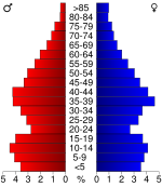
In the county the population was spread out with 28.70% under the age of 18, 8.00% from 18 to 24, 30.90% from 25 to 44, 21.90% from 45 to 64, and 10.40% who were 65 years of age or older. The median age was 35 years. For every 100 females there were 96.80 males. For every 100 females age 18 and over, there were 93.50 males.
The median income for a household in the county was $40,314, and the median income for a family was $46,173. Males had a median income of $32,451 versus $22,897 for females. The per capita income
for the county was $17,397. About 8.10% of families and 10.50% of the population were below the poverty line, including 12.20% of those under age 18 and 13.60% of those age 65 or over.
County (United States)
In the United States, a county is a geographic subdivision of a state , usually assigned some governmental authority. The term "county" is used in 48 of the 50 states; Louisiana is divided into parishes and Alaska into boroughs. Parishes and boroughs are called "county-equivalents" by the U.S...
located in the U.S. state
U.S. state
A U.S. state is any one of the 50 federated states of the United States of America that share sovereignty with the federal government. Because of this shared sovereignty, an American is a citizen both of the federal entity and of his or her state of domicile. Four states use the official title of...
of Arkansas
Arkansas
Arkansas is a state located in the southern region of the United States. Its name is an Algonquian name of the Quapaw Indians. Arkansas shares borders with six states , and its eastern border is largely defined by the Mississippi River...
. Its population was 68,356 at the 2010 United States Census
United States Census, 2010
The Twenty-third United States Census, known as Census 2010 or the 2010 Census, is the current national census of the United States. National Census Day was April 1, 2010 and is the reference date used in enumerating individuals...
. The county seat
County seat
A county seat is an administrative center, or seat of government, for a county or civil parish. The term is primarily used in the United States....
is at Lonoke
Lonoke, Arkansas
Lonoke is the second most populous city in Lonoke County, Arkansas, United States, and serves as its county seat. According to 2005 Census Bureau estimates, the population of the city is 4,553...
, while Cabot
Cabot, Arkansas
As of the census of 2000, there were 15,269 people, 5,432 households, and 4,329 families residing in the city. The population density was 798.2 people per square mile . There were 5,712 housing units at an average density of 298.8 per square mile...
is the largest city in the county. Lonoke County is included in the Little Rock
Little Rock, Arkansas
Little Rock is the capital and the largest city of the U.S. state of Arkansas. The Metropolitan Statistical Area had a population of 699,757 people in the 2010 census...
–North Little Rock
North Little Rock, Arkansas
the city was 62.55% White, 33.98% Black or African American, 0.41% Native American, 0.59% Asian, 0.03% Pacific Islander, 1.18% from other races, and 1.26% from two or more races...
–Conway
Conway, Arkansas
Conway is the county seat of Faulkner County, Arkansas, United States. The population was 58,908 at the 2010 census, making Conway the seventh most populous city in Arkansas. It is a principal city of the Little Rock–North Little Rock–Conway Metropolitan Statistical Area which had...
Metropolitan Statistical Area. It is also an alcohol prohibition or dry county
Dry county
A dry county is a county in the United States whose government forbids the sale of alcoholic beverages. Some prohibit off-premises sale, some prohibit on-premises sale, and some prohibit both. Hundreds of dry counties exist across the United States, almost all of them in the South...
.
Lonoke County is Arkansas's 70th county, formed on 16 April 1873. Its name originates from a "lone oak" tree that stood on the site of the present county seat; the red oak tree was used as a local landmark by a railroad surveyor. Among Arkansas's 75 counties, it is the only one to share its name with its county seat.
The county is the location of the Camp Nelson Confederate Cemetery
Camp Nelson Confederate Cemetery
Camp Nelson Confederate Cemetery is a historic cemetery located near Cabot in northern Lonoke County, Arkansas and is the site of Confederate military camp where 1,500 Confederate soldiers died during an epidemic during the fall of 1862....
, Toltec Mounds State Park, and the Joe Hogan Fish Hatchery — one of the world's largest working fish hatcheries.
The county is served by the National Weather Service
National Weather Service
The National Weather Service , once known as the Weather Bureau, is one of the six scientific agencies that make up the National Oceanic and Atmospheric Administration of the United States government...
Forecast Office in North Little Rock
North Little Rock, Arkansas
the city was 62.55% White, 33.98% Black or African American, 0.41% Native American, 0.59% Asian, 0.03% Pacific Islander, 1.18% from other races, and 1.26% from two or more races...
.
Geography
According to the 2000 census, the county has a total area of 802.43 square miles (2,078.3 km²), of which 765.96 square miles (1,983.8 km²) (or 95.46%) is land and 36.47 square miles (94.5 km²) (or 4.54%) is water.Major highways
.svg.png) Interstate 40Interstate 40Interstate 40 is the third-longest major east–west Interstate Highway in the United States, after I-90 and I-80. Its western end is at Interstate 15 in Barstow, California; its eastern end is at a concurrency of U.S. Route 117 and North Carolina Highway 132 in Wilmington, North Carolina...
Interstate 40Interstate 40Interstate 40 is the third-longest major east–west Interstate Highway in the United States, after I-90 and I-80. Its western end is at Interstate 15 in Barstow, California; its eastern end is at a concurrency of U.S. Route 117 and North Carolina Highway 132 in Wilmington, North Carolina... U.S. Highway 67
 U.S. Highway 70
 U.S. Highway 165
 U.S. Highway 167
 Highway 5
 Highway 13
 Highway 15
 Highway 31
 Highway 38
 Highway 89
Adjacent counties
- White CountyWhite County, ArkansasWhite County is a county located in the U.S. state of Arkansas. As of 2010, the population was 77,076. The county seat is Searcy. White County is Arkansas's 31st county, formed on October 23, 1835, from portions of Independence, Jackson, and Pulaski counties and named for Hugh Lawson White, a...
(north) - Prairie County (east)
- Arkansas CountyArkansas County, ArkansasArkansas County is a county located in the U.S. state of Arkansas. As of the 2010 census, the population was 19,019. The county has two county seats, De Witt and Stuttgart...
(southeast) - Jefferson CountyJefferson County, ArkansasJefferson County is a county located in the U.S. state of Arkansas. Its population was 77,435 at the 2010 United States Census. It is included in the Pine Bluff Metropolitan Statistical Area. Jefferson County's county seat and largest city is Pine Bluff...
(south) - Pulaski County (west)
- Faulkner County (northwest)
Demographics
Census
A census is the procedure of systematically acquiring and recording information about the members of a given population. It is a regularly occurring and official count of a particular population. The term is used mostly in connection with national population and housing censuses; other common...
of 2000, there were 52,828 people, 19,262 households, and 15,024 families residing in the county. The population density
Population density
Population density is a measurement of population per unit area or unit volume. It is frequently applied to living organisms, and particularly to humans...
was 69 people per square mile (27/km²). There were 20,749 housing units at an average density of 27 per square mile (10/km²). The racial makeup of the county was 91.03% White
Race (United States Census)
Race and ethnicity in the United States Census, as defined by the Federal Office of Management and Budget and the United States Census Bureau, are self-identification data items in which residents choose the race or races with which they most closely identify, and indicate whether or not they are...
, 6.44% Black
Race (United States Census)
Race and ethnicity in the United States Census, as defined by the Federal Office of Management and Budget and the United States Census Bureau, are self-identification data items in which residents choose the race or races with which they most closely identify, and indicate whether or not they are...
or African American
Race (United States Census)
Race and ethnicity in the United States Census, as defined by the Federal Office of Management and Budget and the United States Census Bureau, are self-identification data items in which residents choose the race or races with which they most closely identify, and indicate whether or not they are...
, 0.49% Native American
Race (United States Census)
Race and ethnicity in the United States Census, as defined by the Federal Office of Management and Budget and the United States Census Bureau, are self-identification data items in which residents choose the race or races with which they most closely identify, and indicate whether or not they are...
, 0.42% Asian
Race (United States Census)
Race and ethnicity in the United States Census, as defined by the Federal Office of Management and Budget and the United States Census Bureau, are self-identification data items in which residents choose the race or races with which they most closely identify, and indicate whether or not they are...
, 0.03% Pacific Islander
Race (United States Census)
Race and ethnicity in the United States Census, as defined by the Federal Office of Management and Budget and the United States Census Bureau, are self-identification data items in which residents choose the race or races with which they most closely identify, and indicate whether or not they are...
, 0.51% from other races
Race (United States Census)
Race and ethnicity in the United States Census, as defined by the Federal Office of Management and Budget and the United States Census Bureau, are self-identification data items in which residents choose the race or races with which they most closely identify, and indicate whether or not they are...
, and 1.08% from two or more races. 1.75% of the population were Hispanic
Race (United States Census)
Race and ethnicity in the United States Census, as defined by the Federal Office of Management and Budget and the United States Census Bureau, are self-identification data items in which residents choose the race or races with which they most closely identify, and indicate whether or not they are...
or Latino
Race (United States Census)
Race and ethnicity in the United States Census, as defined by the Federal Office of Management and Budget and the United States Census Bureau, are self-identification data items in which residents choose the race or races with which they most closely identify, and indicate whether or not they are...
of any race.
There were 19,262 households out of which 40.30% had children under the age of 18 living with them, 63.30% were married couples
Marriage
Marriage is a social union or legal contract between people that creates kinship. It is an institution in which interpersonal relationships, usually intimate and sexual, are acknowledged in a variety of ways, depending on the culture or subculture in which it is found...
living together, 10.60% had a female householder with no husband present, and 22.00% were non-families. 19.00% of all households were made up of individuals and 7.60% had someone living alone who was 65 years of age or older. The average household size was 2.71 and the average family size was 3.09.
In the county the population was spread out with 28.70% under the age of 18, 8.00% from 18 to 24, 30.90% from 25 to 44, 21.90% from 45 to 64, and 10.40% who were 65 years of age or older. The median age was 35 years. For every 100 females there were 96.80 males. For every 100 females age 18 and over, there were 93.50 males.
The median income for a household in the county was $40,314, and the median income for a family was $46,173. Males had a median income of $32,451 versus $22,897 for females. The per capita income
Per capita income
Per capita income or income per person is a measure of mean income within an economic aggregate, such as a country or city. It is calculated by taking a measure of all sources of income in the aggregate and dividing it by the total population...
for the county was $17,397. About 8.10% of families and 10.50% of the population were below the poverty line, including 12.20% of those under age 18 and 13.60% of those age 65 or over.
Cities and towns
|
Carlisle, Arkansas Carlisle is a city in Lonoke County, Arkansas, United States. It is the easternmost municipality within the Little Rock–North Little Rock–Conway Metropolitan Statistical Area... Coy, Arkansas Coy is a town in Lonoke County, Arkansas, United States. The population was 116 at the 2000 census, making it the smallest incorporated community within the Little Rock–North Little Rock–Conway Metropolitan Statistical Area, as well as one of the smallest in the state.The town is served... England, Arkansas England is a city in southwestern Lonoke County, Arkansas, United States, and the county's third most populous city. The population was 2,972 at the 2000 census. It is part of the Little Rock–North Little Rock–Conway Metropolitan Statistical Area. England is home of the England Lions... |
Humnoke, Arkansas Humnoke is a city in Lonoke County, Arkansas, United States. The population was 280 at the 2000 census. It is part of the Little Rock–North Little Rock–Conway Metropolitan Statistical Area.... Keo, Arkansas Keo is a town in Lonoke County, Arkansas, United States. The population was 235 at the 2000 census. It is part of the Little Rock–North Little Rock–Conway Metropolitan Statistical Area.... Lonoke, Arkansas Lonoke is the second most populous city in Lonoke County, Arkansas, United States, and serves as its county seat. According to 2005 Census Bureau estimates, the population of the city is 4,553... |
Ward, Arkansas Ward is the fourth most populous city in Lonoke County, Arkansas, United States. The population was 2,580 at the 2000 census. It is part of the Little Rock–North Little Rock–Conway Metropolitan Statistical Area.-Geography:... |
Townships
- Butler
- Carlisle (CarlisleCarlisle, ArkansasCarlisle is a city in Lonoke County, Arkansas, United States. It is the easternmost municipality within the Little Rock–North Little Rock–Conway Metropolitan Statistical Area...
) - Caroline (AustinAustin, ArkansasAustin is a city in Lonoke County, Arkansas, United States. The population was 1,000+ by 2010. It is part of the Little Rock–North Little Rock–Conway Metropolitan Statistical Area....
, small part of CabotCabot, ArkansasAs of the census of 2000, there were 15,269 people, 5,432 households, and 4,329 families residing in the city. The population density was 798.2 people per square mile . There were 5,712 housing units at an average density of 298.8 per square mile...
, part of WardWard, ArkansasWard is the fourth most populous city in Lonoke County, Arkansas, United States. The population was 2,580 at the 2000 census. It is part of the Little Rock–North Little Rock–Conway Metropolitan Statistical Area.-Geography:...
) - Cleveland
- Crooked Creek (AllportAllport, ArkansasAllport is a town in Lonoke County, Arkansas, United States. The population was 127 at the 2000 census. It is part of the Little Rock–North Little Rock–Conway Metropolitan Statistical Area....
, HumnokeHumnoke, ArkansasHumnoke is a city in Lonoke County, Arkansas, United States. The population was 280 at the 2000 census. It is part of the Little Rock–North Little Rock–Conway Metropolitan Statistical Area....
) - Dortch (CDP ScottScott, ArkansasScott is a census-designated place in Lonoke and Pulaski counties in the central part of the U.S. state of Arkansas. The population was 72 at the 2010 census...
) - Eagle
- Fletcher
- Furlow
- Goodrum
- Gray
- Gum Woods (EnglandEngland, ArkansasEngland is a city in southwestern Lonoke County, Arkansas, United States, and the county's third most populous city. The population was 2,972 at the 2000 census. It is part of the Little Rock–North Little Rock–Conway Metropolitan Statistical Area. England is home of the England Lions...
) - Hamilton
- Indian Bayou (CoyCoy, ArkansasCoy is a town in Lonoke County, Arkansas, United States. The population was 116 at the 2000 census, making it the smallest incorporated community within the Little Rock–North Little Rock–Conway Metropolitan Statistical Area, as well as one of the smallest in the state.The town is served...
) - Isbell
- Lafayette (KeoKeo, ArkansasKeo is a town in Lonoke County, Arkansas, United States. The population was 235 at the 2000 census. It is part of the Little Rock–North Little Rock–Conway Metropolitan Statistical Area....
) - Lonoke (LonokeLonoke, ArkansasLonoke is the second most populous city in Lonoke County, Arkansas, United States, and serves as its county seat. According to 2005 Census Bureau estimates, the population of the city is 4,553...
) - Magness (part of CabotCabot, ArkansasAs of the census of 2000, there were 15,269 people, 5,432 households, and 4,329 families residing in the city. The population density was 798.2 people per square mile . There were 5,712 housing units at an average density of 298.8 per square mile...
) - Oak Grove (small part of CabotCabot, ArkansasAs of the census of 2000, there were 15,269 people, 5,432 households, and 4,329 families residing in the city. The population density was 798.2 people per square mile . There were 5,712 housing units at an average density of 298.8 per square mile...
) - Pettus
- Prairie
- Pulaski
- Richwoods
- Scott
- Totten
- Walls
- Ward (part of WardWard, ArkansasWard is the fourth most populous city in Lonoke County, Arkansas, United States. The population was 2,580 at the 2000 census. It is part of the Little Rock–North Little Rock–Conway Metropolitan Statistical Area.-Geography:...
) - Williams
- York (most of CabotCabot, ArkansasAs of the census of 2000, there were 15,269 people, 5,432 households, and 4,329 families residing in the city. The population density was 798.2 people per square mile . There were 5,712 housing units at an average density of 298.8 per square mile...
)