
Poinsett County, Arkansas
Encyclopedia
Poinsett County is a county
located in the U.S. state
of Arkansas
. As of 2010, the population was 24,583. It is included in the Jonesboro, Arkansas Metropolitan Statistical Area
. The county seat
is Harrisburg
. The county was formed on February 28, 1838, and named for Joel R. Poinsett, U.S. Secretary of War
. The first county seat was Bolivar, located three miles north of town on the Old Military Road, though all that remains of Bolivar is a cemetery.
|----- valign="top"
|
 As of the census
of 2000, there were 25,614 people, 10,026 households, and 7,228 families residing in the county. The population density
was 34 people per square mile (13/km²). There were 11,051 housing units at an average density of 15 per square mile (6/km²). The racial makeup of the county was 90.98% White
, 7.13% Black
or African American
, 0.23% Native American
, 0.16% Asian
, 0.02% Pacific Islander
, 0.74% from other races
, and 0.75% from two or more races. 1.43% of the population were Hispanic
or Latino
of any race.
There were 10,026 households out of which 32.60% had children under the age of 18 living with them, 54.60% were married couples
living together, 13.20% had a female householder with no husband present, and 27.90% were non-families. 24.80% of all households were made up of individuals and 11.70% had someone living alone who was 65 years of age or older. The average household size was 2.52 and the average family size was 2.99.
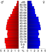
In the county the population was spread out with 26.10% under the age of 18, 8.90% from 18 to 24, 27.10% from 25 to 44, 23.70% from 45 to 64, and 14.30% who were 65 years of age or older. The median age was 37 years. For every 100 females there were 94.60 males. For every 100 females age 18 and over, there were 90.30 males.
The median income for a household in the county was $26,558, and the median income for a family was $32,257. Males had a median income of $26,633 versus $19,199 for females. The per capita income
for the county was $13,087. About 17.60% of families and 21.20% of the population were below the poverty line, including 28.60% of those under age 18 and 20.50% of those age 65 or over.
|----- valign="top"
|
|
|
|
|}
County (United States)
In the United States, a county is a geographic subdivision of a state , usually assigned some governmental authority. The term "county" is used in 48 of the 50 states; Louisiana is divided into parishes and Alaska into boroughs. Parishes and boroughs are called "county-equivalents" by the U.S...
located in the U.S. state
U.S. state
A U.S. state is any one of the 50 federated states of the United States of America that share sovereignty with the federal government. Because of this shared sovereignty, an American is a citizen both of the federal entity and of his or her state of domicile. Four states use the official title of...
of Arkansas
Arkansas
Arkansas is a state located in the southern region of the United States. Its name is an Algonquian name of the Quapaw Indians. Arkansas shares borders with six states , and its eastern border is largely defined by the Mississippi River...
. As of 2010, the population was 24,583. It is included in the Jonesboro, Arkansas Metropolitan Statistical Area
Jonesboro metropolitan area
The Jonesboro Metropolitan Statistical Area, as defined by the United States Census Bureau, is an area consisting of two counties – Craighead and Poinsett – in northeast Arkansas, anchored by the city of Jonesboro. As of the 2000 census, the MSA had a population of 107,762...
. The county seat
County seat
A county seat is an administrative center, or seat of government, for a county or civil parish. The term is primarily used in the United States....
is Harrisburg
Harrisburg, Arkansas
Harrisburg is a city in Poinsett County, Arkansas, United States. The population was 2,192 at the 2000 census. It is included in the Jonesboro, Arkansas Metropolitan Statistical Area...
. The county was formed on February 28, 1838, and named for Joel R. Poinsett, U.S. Secretary of War
United States Secretary of War
The Secretary of War was a member of the United States President's Cabinet, beginning with George Washington's administration. A similar position, called either "Secretary at War" or "Secretary of War," was appointed to serve the Congress of the Confederation under the Articles of Confederation...
. The first county seat was Bolivar, located three miles north of town on the Old Military Road, though all that remains of Bolivar is a cemetery.
Geography
According to the 2000 census, the county has a total area of 763.39 square miles (1,977.2 km²), of which 757.74 square miles (1,962.5 km²) (or 99.26%) is land and 5.65 square miles (14.6 km²) (or 0.74%) is water.List Of Highways
{||----- valign="top"
|
- Future Interstate 555Interstate 555Interstate 555 is a future Interstate Highway that is slated to connect Turrell, Arkansas at Interstate 55 to Jonesboro, Arkansas at Highway 91. I-555 is currently under construction as U.S...
 U.S. Highway 49
 U.S. Highway 63
 Highway 1
 Highway 14
 Highway 18
 Highway 69
 Highway 75
 Highway 118Arkansas Highway 118Arkansas Highway 118 is a long state highway in Eastern Arkansas. It contains no spur or business routes.-Route description:Arkansas Highway 118 begins at US 70/US 79 in West Memphis and heads north to meet Interstate 40 before hitting US 64 and angling east by Crawfordsville and Earle. Heading...
 Highway 135Arkansas Highway 135Arkansas Highway 135 is a north–south state highway in northeast Arkansas. The route of runs from US 63 near Tyronza north through Paragould to US 62.-Route description:...
 Highway 136Arkansas Highway 136Arkansas Highway 136 is a state highway in Arkansas.-Route description:AR 136 begins at AR 135 east of Rivervale. The route runs east to concur northeasterly with AR 140. The route continues alone to Etowah, then turning east to terminate at AR 77....
 Highway 140Arkansas Highway 140-Route description:AR 140 begins at US 63 BUS in Marked Tree. It runs north with AR 14 until Lepanto, where the route crosses AR 135. AR 140 then heads northeast, briefly concurring with AR 136 and AR 181 individually before crossing under Interstate 55....
 Highway 149
 Highway 158Arkansas Highway 158Arkansas Highway 158 is a designation for two state highways in northeast Arkansas. The main segment of runs east from AR 1 to US 61 in Luxora. A short route of runs from U.S. Route 49 across railroad tracks in rural Craighead County.-Route description:...
 Highway 163Arkansas Highway 163Arkansas Highway 163 is a state highway of that runs in Craighead, Poinsett, and Cross Counties.-Route description:AR 163 begins at CR 739 in rural Cross County. The route runs north to cross US 64 in Levesque and AR 42 in Birdeye. AR 163 runs through Lake Poinsett State Park near Lake Poinsett...
 Highway 198Arkansas Highway 198-Section 1:Arkansas Highway 198 is a state highway of that runs in Poinsett and Mississippi Counties.-Route description:AR 198 runs east from AR 140 to AR 77/AR 297...
 Highway 214
 Highway 308Arkansas Highway 308-Section 1:Arkansas Highway 308 is a state highway of that runs in Mississippi County.-Route description:AR 308 begins at AR 118 and runs south to Birdsong. The route then turns north to concur with AR 77 briefly...
 Highway 322
- Highway 373
 Highway 463
Adjacent counties
- Craighead CountyCraighead County, ArkansasCraighead County is a county located in the U.S. state of Arkansas. As of the 2010 census, the population was 96,443. It is included in the Jonesboro, Arkansas Metropolitan Statistical Area. Craighead County is Arkansas's 58th county, formed on February 19, 1859, and named for state Senator Thomas...
(north) - Mississippi County (east)
- Crittenden County (southeast)
- Cross County (south)
- Jackson County (west)
Demographics
Census
A census is the procedure of systematically acquiring and recording information about the members of a given population. It is a regularly occurring and official count of a particular population. The term is used mostly in connection with national population and housing censuses; other common...
of 2000, there were 25,614 people, 10,026 households, and 7,228 families residing in the county. The population density
Population density
Population density is a measurement of population per unit area or unit volume. It is frequently applied to living organisms, and particularly to humans...
was 34 people per square mile (13/km²). There were 11,051 housing units at an average density of 15 per square mile (6/km²). The racial makeup of the county was 90.98% White
Race (United States Census)
Race and ethnicity in the United States Census, as defined by the Federal Office of Management and Budget and the United States Census Bureau, are self-identification data items in which residents choose the race or races with which they most closely identify, and indicate whether or not they are...
, 7.13% Black
Race (United States Census)
Race and ethnicity in the United States Census, as defined by the Federal Office of Management and Budget and the United States Census Bureau, are self-identification data items in which residents choose the race or races with which they most closely identify, and indicate whether or not they are...
or African American
Race (United States Census)
Race and ethnicity in the United States Census, as defined by the Federal Office of Management and Budget and the United States Census Bureau, are self-identification data items in which residents choose the race or races with which they most closely identify, and indicate whether or not they are...
, 0.23% Native American
Race (United States Census)
Race and ethnicity in the United States Census, as defined by the Federal Office of Management and Budget and the United States Census Bureau, are self-identification data items in which residents choose the race or races with which they most closely identify, and indicate whether or not they are...
, 0.16% Asian
Race (United States Census)
Race and ethnicity in the United States Census, as defined by the Federal Office of Management and Budget and the United States Census Bureau, are self-identification data items in which residents choose the race or races with which they most closely identify, and indicate whether or not they are...
, 0.02% Pacific Islander
Race (United States Census)
Race and ethnicity in the United States Census, as defined by the Federal Office of Management and Budget and the United States Census Bureau, are self-identification data items in which residents choose the race or races with which they most closely identify, and indicate whether or not they are...
, 0.74% from other races
Race (United States Census)
Race and ethnicity in the United States Census, as defined by the Federal Office of Management and Budget and the United States Census Bureau, are self-identification data items in which residents choose the race or races with which they most closely identify, and indicate whether or not they are...
, and 0.75% from two or more races. 1.43% of the population were Hispanic
Race (United States Census)
Race and ethnicity in the United States Census, as defined by the Federal Office of Management and Budget and the United States Census Bureau, are self-identification data items in which residents choose the race or races with which they most closely identify, and indicate whether or not they are...
or Latino
Race (United States Census)
Race and ethnicity in the United States Census, as defined by the Federal Office of Management and Budget and the United States Census Bureau, are self-identification data items in which residents choose the race or races with which they most closely identify, and indicate whether or not they are...
of any race.
There were 10,026 households out of which 32.60% had children under the age of 18 living with them, 54.60% were married couples
Marriage
Marriage is a social union or legal contract between people that creates kinship. It is an institution in which interpersonal relationships, usually intimate and sexual, are acknowledged in a variety of ways, depending on the culture or subculture in which it is found...
living together, 13.20% had a female householder with no husband present, and 27.90% were non-families. 24.80% of all households were made up of individuals and 11.70% had someone living alone who was 65 years of age or older. The average household size was 2.52 and the average family size was 2.99.
In the county the population was spread out with 26.10% under the age of 18, 8.90% from 18 to 24, 27.10% from 25 to 44, 23.70% from 45 to 64, and 14.30% who were 65 years of age or older. The median age was 37 years. For every 100 females there were 94.60 males. For every 100 females age 18 and over, there were 90.30 males.
The median income for a household in the county was $26,558, and the median income for a family was $32,257. Males had a median income of $26,633 versus $19,199 for females. The per capita income
Per capita income
Per capita income or income per person is a measure of mean income within an economic aggregate, such as a country or city. It is calculated by taking a measure of all sources of income in the aggregate and dividing it by the total population...
for the county was $13,087. About 17.60% of families and 21.20% of the population were below the poverty line, including 28.60% of those under age 18 and 20.50% of those age 65 or over.
Cities and towns
{||----- valign="top"
|
- FisherFisher, ArkansasFisher is a town in Poinsett County, Arkansas, United States. The population was 265 at the 2000 census. It is included in the Jonesboro, Arkansas Metropolitan Statistical Area.-Geography:Fisher is located at ....
- GreenfieldGreenfield, ArkansasGreenfield is an unincorporated community in Poinsett County, Arkansas, United States. A railroad town founded along the Missouri Pacific, it lies five miles north of Harrisburg, and about ten miles south of Jonesboro on the new Highway 1...
- HarrisburgHarrisburg, ArkansasHarrisburg is a city in Poinsett County, Arkansas, United States. The population was 2,192 at the 2000 census. It is included in the Jonesboro, Arkansas Metropolitan Statistical Area...
|
- LepantoLepanto, ArkansasLepanto is a city in Poinsett County, Arkansas, United States. The population was 2,133 at the 2000 census. It is included in the Jonesboro, Arkansas Metropolitan Statistical Area...
- Marked TreeMarked Tree, ArkansasMarked Tree is a city in Poinsett County, Arkansas in the United States, along the St. Francis River, at the mouth of the Little River. The population was 2,800 at the 2000 census. It is included in the Jonesboro, Arkansas Metropolitan Statistical Area....
- RivervaleRivervale, ArkansasRivervale is an unincorporated community in Poinsett County, Arkansas, United States, approximately five miles north of Lepanto.The Rivervale Tunnel, an engineering project in which one river flows under another, is located near Rivervale.-External links:*...
|
- TrumannTrumann, ArkansasTrumann is a city in Poinsett County, Arkansas, United States. The population was 6,889 at the 2000 census. It is included in the Jonesboro, Arkansas Metropolitan Statistical Area.-Geography:Trumann is located at ....
- TyronzaTyronza, ArkansasTyronza is a town in Poinsett County, Arkansas, United States. The population was 762 at the 2010 census. It is included in the Jonesboro, Arkansas Metropolitan Statistical Area.-Geography:Tyronza is located at ....
|
- WaldenburgWaldenburg, ArkansasWaldenburg is a town in Poinsett County, Arkansas, United States. The population was 80 at the 2000 census. It is included in the Jonesboro, Arkansas Metropolitan Statistical Area.-Geography:Waldenburg is located at ....
- WeinerWeiner, ArkansasWeiner is a city in Poinsett County, Arkansas, United States. The population was 760 at the 2000 census. It is included in the Jonesboro, Arkansas Metropolitan Statistical Area.-Geography:Weiner is located at ....
|}
Townships
- Boliver (HarrisburgHarrisburg, ArkansasHarrisburg is a city in Poinsett County, Arkansas, United States. The population was 2,192 at the 2000 census. It is included in the Jonesboro, Arkansas Metropolitan Statistical Area...
) - Dobson
- Greenfield
- Greenwood (LepantoLepanto, ArkansasLepanto is a city in Poinsett County, Arkansas, United States. The population was 2,133 at the 2000 census. It is included in the Jonesboro, Arkansas Metropolitan Statistical Area...
) - Little River (Marked TreeMarked Tree, ArkansasMarked Tree is a city in Poinsett County, Arkansas in the United States, along the St. Francis River, at the mouth of the Little River. The population was 2,800 at the 2000 census. It is included in the Jonesboro, Arkansas Metropolitan Statistical Area....
) - Lunsford
- Owen (FisherFisher, ArkansasFisher is a town in Poinsett County, Arkansas, United States. The population was 265 at the 2000 census. It is included in the Jonesboro, Arkansas Metropolitan Statistical Area.-Geography:Fisher is located at ....
, WaldenburgWaldenburg, ArkansasWaldenburg is a town in Poinsett County, Arkansas, United States. The population was 80 at the 2000 census. It is included in the Jonesboro, Arkansas Metropolitan Statistical Area.-Geography:Waldenburg is located at ....
) - Scott
- Tyronza (TyronzaTyronza, ArkansasTyronza is a town in Poinsett County, Arkansas, United States. The population was 762 at the 2010 census. It is included in the Jonesboro, Arkansas Metropolitan Statistical Area.-Geography:Tyronza is located at ....
) - West Prairie (WeinerWeiner, ArkansasWeiner is a city in Poinsett County, Arkansas, United States. The population was 760 at the 2000 census. It is included in the Jonesboro, Arkansas Metropolitan Statistical Area.-Geography:Weiner is located at ....
) - Willis (TrumannTrumann, ArkansasTrumann is a city in Poinsett County, Arkansas, United States. The population was 6,889 at the 2000 census. It is included in the Jonesboro, Arkansas Metropolitan Statistical Area.-Geography:Trumann is located at ....
)