

Chicot County, Arkansas
Encyclopedia
Chicot County is a county
located in the U.S. state
of Arkansas
. As of 2010, the population is 11,800. The county seat
is Lake Village
. Chicot County is Arkansas's tenth county, formed on October 25, 1823, and named after Point Chicot on the Mississippi River
.
Landmarks around the county include Lake Chicot
, North America's largest oxbow lake
and Arkansas's largest natural lake; the site of Charles Lindbergh
's first night-time flight; and the legendary burial site of Hernando De Soto
, near Lake Village.
 As of the census
of 2000, there were 14,117 people, 5,205 households, and 3,643 families residing in the county. The population density
was 22 people per square mile (8/km²). There were 5,974 housing units at an average density of 9 per square mile (4/km²). The racial makeup of the county was 43.24% White
, 53.96% Black
or African American
, 0.13% Native American
, 0.40% Asian
, 0.02% Pacific Islander
, 1.41% from other races
, and 0.85% from two or more races. 2.88% of the population were Hispanic
or Latino
of any race.
There were 5,205 households out of which 31.70% had children under the age of 18 living with them, 43.70% were married couples
living together, 22.00% had a female householder with no husband present, and 30.00% were non-families. 26.90% of all households were made up of individuals and 13.00% had someone living alone who was 65 years of age or older. The average household size was 2.58 and the average family size was 3.12.
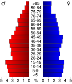
In the county the population was spread out with 27.50% under the age of 18, 8.60% from 18 to 24, 26.40% from 25 to 44, 22.20% from 45 to 64, and 15.40% who were 65 years of age or older. The median age was 36 years. For every 100 females there were 94.20 males. For every 100 females age 18 and over, there were 89.90 males.
The median income for a household in the county was $22,024, and the median income for a family was $27,960. Males had a median income of $25,899 versus $17,115 for females. The per capita income
for the county was $12,825. About 23.10% of families and 28.60% of the population were below the poverty line, including 38.30% of those under age 18 and 20.70% of those age 65 or over.
As of 2010 the county population was 11,800. The racial make-up was 40.35% Non-Hispanic whites, 54.08% blacks, 0.19% Native Americans, 0.47% Asians, 0.03% Pacific Islanders and 4.59% Hispanics or Latinos.
. Although there's been some trending toward the Republicans the Republican Presidential candidate has not received over 40% in any of the last five Presidential elections.
It is part of Arkansas's 4th congressional district
, which is represented by Democrat Mike Ross. In the Arkansas Senate
the county is in District 24 and is represented by Democrat Jimmy Jeffress. In the Arkansas House of Representatives
it is in District 12 and represented by Democrat Robert Moore. The county supported a measure prohibiting "co-habiting couples" from adopting.
County (United States)
In the United States, a county is a geographic subdivision of a state , usually assigned some governmental authority. The term "county" is used in 48 of the 50 states; Louisiana is divided into parishes and Alaska into boroughs. Parishes and boroughs are called "county-equivalents" by the U.S...
located in the U.S. state
U.S. state
A U.S. state is any one of the 50 federated states of the United States of America that share sovereignty with the federal government. Because of this shared sovereignty, an American is a citizen both of the federal entity and of his or her state of domicile. Four states use the official title of...
of Arkansas
Arkansas
Arkansas is a state located in the southern region of the United States. Its name is an Algonquian name of the Quapaw Indians. Arkansas shares borders with six states , and its eastern border is largely defined by the Mississippi River...
. As of 2010, the population is 11,800. The county seat
County seat
A county seat is an administrative center, or seat of government, for a county or civil parish. The term is primarily used in the United States....
is Lake Village
Lake Village, Arkansas
Lake Village is a city in Chicot County, Arkansas, United States. The population was 2,823 at the 2000 census. The city is the county seat of Chicot County.Lake Village is named for its location on Lake Chicot, an oxbow lake formed from the Mississippi River...
. Chicot County is Arkansas's tenth county, formed on October 25, 1823, and named after Point Chicot on the Mississippi River
Mississippi River
The Mississippi River is the largest river system in North America. Flowing entirely in the United States, this river rises in western Minnesota and meanders slowly southwards for to the Mississippi River Delta at the Gulf of Mexico. With its many tributaries, the Mississippi's watershed drains...
.
Landmarks around the county include Lake Chicot
Lake Chicot
Lake Chicot is a lake located near Lake Village, Arkansas. It is the largest oxbow lake in North America and the largest natural lake in Arkansas, formed 600 years ago by the meandering of the Mississippi River....
, North America's largest oxbow lake
Oxbow lake
An oxbow lake is a U-shaped body of water formed when a wide meander from the main stem of a river is cut off to create a lake. This landform is called an oxbow lake for the distinctive curved shape, named after part of a yoke for oxen. In Australia, an oxbow lake is called a billabong, derived...
and Arkansas's largest natural lake; the site of Charles Lindbergh
Charles Lindbergh
Charles Augustus Lindbergh was an American aviator, author, inventor, explorer, and social activist.Lindbergh, a 25-year-old U.S...
's first night-time flight; and the legendary burial site of Hernando De Soto
Hernando de Soto (explorer)
Hernando de Soto was a Spanish explorer and conquistador who, while leading the first European expedition deep into the territory of the modern-day United States, was the first European documented to have crossed the Mississippi River....
, near Lake Village.
Geography
According to the 2000 census, the county has a total area of 690.88 square miles (1,789.4 km²), of which 644.03 square miles (1,668 km²) (or 93.22%) is land and 46.86 square miles (121.4 km²) (or 6.78%) is water.Major highways
 U.S. Highway 65
 U.S. Highway 82
 U.S. Highway 165
 U.S. Highway 278
 Highway 8
 Highway 35
 Highway 159
Adjacent counties
- Desha CountyDesha County, ArkansasDesha County is a county located in the U.S. state of Arkansas. As of the 2010 census, the population was 13,008. The county seat is Arkansas City. Desha County is Arkansas's 40th county, formed on December 12, 1838, and named for Captain Benjamin Desha who fought in the War of...
(north) - Washington CountyWashington County, Mississippi-National protected areas:*Holt Collier National Wildlife Refuge*Theodore Roosevelt National Wildlife Refuge *Yazoo National Wildlife Refuge-Demographics:...
, MississippiMississippiMississippi is a U.S. state located in the Southern United States. Jackson is the state capital and largest city. The name of the state derives from the Mississippi River, which flows along its western boundary, whose name comes from the Ojibwe word misi-ziibi...
(east) - Issaquena CountyIssaquena County, Mississippi-Demographics:As of the census of 2000, there were 2,274 people, 726 households, and 509 families residing in the county. The population density was 5.15 people per square mile . There were 877 housing units at an average density of 2 per square mile...
, MississippiMississippiMississippi is a U.S. state located in the Southern United States. Jackson is the state capital and largest city. The name of the state derives from the Mississippi River, which flows along its western boundary, whose name comes from the Ojibwe word misi-ziibi...
(southeast) - East Carroll ParishEast Carroll Parish, LouisianaEast Carroll Parish is a parish located in the U.S. state of Louisiana. The parish seat is Lake Providence and as of 2010, the population was 7,759.-Law and government:In the 2004 presidential race, East Carroll gave the George W. Bush - Richard B...
, LouisianaLouisianaLouisiana is a state located in the southern region of the United States of America. Its capital is Baton Rouge and largest city is New Orleans. Louisiana is the only state in the U.S. with political subdivisions termed parishes, which are local governments equivalent to counties...
(south) - West Carroll ParishWest Carroll Parish, LouisianaWest Carroll Parish is a parish located in the U.S. state of Louisiana. The parish seat is Oak Grove and as of 2000, the population was 12,314.-History:...
, LouisianaLouisianaLouisiana is a state located in the southern region of the United States of America. Its capital is Baton Rouge and largest city is New Orleans. Louisiana is the only state in the U.S. with political subdivisions termed parishes, which are local governments equivalent to counties...
(southwest) - Ashley County (west)
- Drew County (northwest)
Demographics
Census
A census is the procedure of systematically acquiring and recording information about the members of a given population. It is a regularly occurring and official count of a particular population. The term is used mostly in connection with national population and housing censuses; other common...
of 2000, there were 14,117 people, 5,205 households, and 3,643 families residing in the county. The population density
Population density
Population density is a measurement of population per unit area or unit volume. It is frequently applied to living organisms, and particularly to humans...
was 22 people per square mile (8/km²). There were 5,974 housing units at an average density of 9 per square mile (4/km²). The racial makeup of the county was 43.24% White
Race (United States Census)
Race and ethnicity in the United States Census, as defined by the Federal Office of Management and Budget and the United States Census Bureau, are self-identification data items in which residents choose the race or races with which they most closely identify, and indicate whether or not they are...
, 53.96% Black
Race (United States Census)
Race and ethnicity in the United States Census, as defined by the Federal Office of Management and Budget and the United States Census Bureau, are self-identification data items in which residents choose the race or races with which they most closely identify, and indicate whether or not they are...
or African American
Race (United States Census)
Race and ethnicity in the United States Census, as defined by the Federal Office of Management and Budget and the United States Census Bureau, are self-identification data items in which residents choose the race or races with which they most closely identify, and indicate whether or not they are...
, 0.13% Native American
Race (United States Census)
Race and ethnicity in the United States Census, as defined by the Federal Office of Management and Budget and the United States Census Bureau, are self-identification data items in which residents choose the race or races with which they most closely identify, and indicate whether or not they are...
, 0.40% Asian
Race (United States Census)
Race and ethnicity in the United States Census, as defined by the Federal Office of Management and Budget and the United States Census Bureau, are self-identification data items in which residents choose the race or races with which they most closely identify, and indicate whether or not they are...
, 0.02% Pacific Islander
Race (United States Census)
Race and ethnicity in the United States Census, as defined by the Federal Office of Management and Budget and the United States Census Bureau, are self-identification data items in which residents choose the race or races with which they most closely identify, and indicate whether or not they are...
, 1.41% from other races
Race (United States Census)
Race and ethnicity in the United States Census, as defined by the Federal Office of Management and Budget and the United States Census Bureau, are self-identification data items in which residents choose the race or races with which they most closely identify, and indicate whether or not they are...
, and 0.85% from two or more races. 2.88% of the population were Hispanic
Race (United States Census)
Race and ethnicity in the United States Census, as defined by the Federal Office of Management and Budget and the United States Census Bureau, are self-identification data items in which residents choose the race or races with which they most closely identify, and indicate whether or not they are...
or Latino
Race (United States Census)
Race and ethnicity in the United States Census, as defined by the Federal Office of Management and Budget and the United States Census Bureau, are self-identification data items in which residents choose the race or races with which they most closely identify, and indicate whether or not they are...
of any race.
There were 5,205 households out of which 31.70% had children under the age of 18 living with them, 43.70% were married couples
Marriage
Marriage is a social union or legal contract between people that creates kinship. It is an institution in which interpersonal relationships, usually intimate and sexual, are acknowledged in a variety of ways, depending on the culture or subculture in which it is found...
living together, 22.00% had a female householder with no husband present, and 30.00% were non-families. 26.90% of all households were made up of individuals and 13.00% had someone living alone who was 65 years of age or older. The average household size was 2.58 and the average family size was 3.12.
In the county the population was spread out with 27.50% under the age of 18, 8.60% from 18 to 24, 26.40% from 25 to 44, 22.20% from 45 to 64, and 15.40% who were 65 years of age or older. The median age was 36 years. For every 100 females there were 94.20 males. For every 100 females age 18 and over, there were 89.90 males.
The median income for a household in the county was $22,024, and the median income for a family was $27,960. Males had a median income of $25,899 versus $17,115 for females. The per capita income
Per capita income
Per capita income or income per person is a measure of mean income within an economic aggregate, such as a country or city. It is calculated by taking a measure of all sources of income in the aggregate and dividing it by the total population...
for the county was $12,825. About 23.10% of families and 28.60% of the population were below the poverty line, including 38.30% of those under age 18 and 20.70% of those age 65 or over.
As of 2010 the county population was 11,800. The racial make-up was 40.35% Non-Hispanic whites, 54.08% blacks, 0.19% Native Americans, 0.47% Asians, 0.03% Pacific Islanders and 4.59% Hispanics or Latinos.
Politics
The county is traditionally Democratic. In the last century the only Democrat to lose the county was George McGovernGeorge McGovern
George Stanley McGovern is an historian, author, and former U.S. Representative, U.S. Senator, and the Democratic Party nominee in the 1972 presidential election....
. Although there's been some trending toward the Republicans the Republican Presidential candidate has not received over 40% in any of the last five Presidential elections.
It is part of Arkansas's 4th congressional district
Arkansas's 4th congressional district
Arkansas's 4th congressional district is a congressional district located in the southern half of the U.S. state of Arkansas. Notable towns in the district include Camden, Hope, Hot Springs, Magnolia, Pine Bluff, and Texarkana....
, which is represented by Democrat Mike Ross. In the Arkansas Senate
Arkansas Senate
The Arkansas State Senate is the upper branch of the Arkansas General Assembly. The Senate consists of 35 members, each representing a district with about 76,000 people. Service in the state legislature is part-time, and many state senators have full-time jobs during the rest of the year. The...
the county is in District 24 and is represented by Democrat Jimmy Jeffress. In the Arkansas House of Representatives
Arkansas House of Representatives
The Arkansas House of Representatives is the lower house of the Arkansas General Assembly, the state legislature of the U.S. state of Arkansas. The House is composed of 100 members elected from an equal amount of constituencies across the state. Each district has an average population of 26,734...
it is in District 12 and represented by Democrat Robert Moore. The county supported a measure prohibiting "co-habiting couples" from adopting.
Notable natives
- Larry D. AlexanderLarry D. AlexanderLarry Dell Alexander is an American artist, Christian author and teacher from Dermott, Arkansas in Chicot County. Alexander is best known for his creations of colorful and black & white "pen and ink" drawings in his "crosshatching" technique, and, his personal rendition of a "Clinton Family...
- Visual Artist/Author - Robert L. HillRobert L. HillRobert Lee Hill was an African American sharecropper from eastern Arkansas and founder of the Progressive Farmers and Household Union of America....
- Founder of the Progressive Farmers and Household Union of AmericaProgressive Farmers and Household Union of AmericaThe Progressive Farmers and Household Union of America was a union of African-American tenant farmers . A meeting of this union at Hoop Spur, Arkansas, was attacked on September 30, 1919, leaving a white sheriff dead and sparking the famous Elaine Race Riot.The Progressive Farmers and Household...
.
Cities and towns
- DermottDermott, ArkansasDermott is a city in Chicot County, Arkansas, United States. The population was 3,292 at the 2000 census. Dermott was incorporated in 1890.Dermott is home to the Dermott Crawfish Festival.-Geography:Dermott is located at ....
- EudoraEudora, ArkansasEudora is a city in Chicot County, Arkansas, United States of America. The population was 2,819 at the 2000 census.-Geography:Eudora is located at ....
- Lake VillageLake Village, ArkansasLake Village is a city in Chicot County, Arkansas, United States. The population was 2,823 at the 2000 census. The city is the county seat of Chicot County.Lake Village is named for its location on Lake Chicot, an oxbow lake formed from the Mississippi River...
Townships
- Bowie (DermottDermott, ArkansasDermott is a city in Chicot County, Arkansas, United States. The population was 3,292 at the 2000 census. Dermott was incorporated in 1890.Dermott is home to the Dermott Crawfish Festival.-Geography:Dermott is located at ....
) - Carlton (Lake VillageLake Village, ArkansasLake Village is a city in Chicot County, Arkansas, United States. The population was 2,823 at the 2000 census. The city is the county seat of Chicot County.Lake Village is named for its location on Lake Chicot, an oxbow lake formed from the Mississippi River...
) - Planters (EudoraEudora, ArkansasEudora is a city in Chicot County, Arkansas, United States of America. The population was 2,819 at the 2000 census.-Geography:Eudora is located at ....
)