
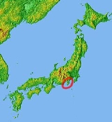
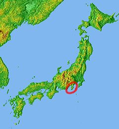
Izu Peninsula
Encyclopedia
Peninsula
A peninsula is a piece of land that is bordered by water on three sides but connected to mainland. In many Germanic and Celtic languages and also in Baltic, Slavic and Hungarian, peninsulas are called "half-islands"....
with deeply indented coasts to the west of Tokyo on the Pacific coast
Pacific Ocean
The Pacific Ocean is the largest of the Earth's oceanic divisions. It extends from the Arctic in the north to the Southern Ocean in the south, bounded by Asia and Australia in the west, and the Americas in the east.At 165.2 million square kilometres in area, this largest division of the World...
of the island of Honshū
Honshu
is the largest island of Japan. The nation's main island, it is south of Hokkaido across the Tsugaru Strait, north of Shikoku across the Inland Sea, and northeast of Kyushu across the Kanmon Strait...
, Japan
Japan
Japan is an island nation in East Asia. Located in the Pacific Ocean, it lies to the east of the Sea of Japan, China, North Korea, South Korea and Russia, stretching from the Sea of Okhotsk in the north to the East China Sea and Taiwan in the south...
. Formerly the eponymous Izu Province
Izu Province
was a province of Japan in the area of Shizuoka Prefecture. Izu bordered on Sagami and Suruga Provinces. Its abbreviated form name was .The mainland portion of Izu Province, comprising the Izu Peninsula is today the eastern portion of Shizuoka Prefecture and the Izu Islands are now part of...
, Izu peninsula is now a part of Shizuoka Prefecture
Shizuoka Prefecture
is a prefecture of Japan located in the Chūbu region on Honshu island. The capital is the city of Shizuoka.- History :Shizuoka prefecture was formed from the former Tōtōmi, Suruga and Izu provinces.The area was the home of the first Tokugawa Shogun...
. The peninsula has an area of 1,421.24 km² and its estimated population in 2005 was 473,942 persons.
Geology
Tectonically, the Izu peninsula results from the Philippine Sea Plate colliding with the Okhotsk PlateOkhotsk Plate
The Okhotsk Plate is a tectonic plate covering the Sea of Okhotsk, the Kamchatka Peninsula, Sakhalin Island and Tōhoku and Hokkaidō in Japan. It was formerly considered a part of the North American Plate, but recent studies indicate that it is an independent plate, bounded on the north by the...
at the Nankai Trough
Nankai Trough
The Nankai Trough is a submarine trough located south of Japan's island of Honshū, extending approximately 900 km offshore. In plate tectonics, the Nankai Trough marks a subduction zone that is caused by subduction of the Philippine Sea Plate beneath Japan, part of the Eurasian plate...
. The Philippine Sea Plate, the Amurian Plate
Amurian Plate
The Amurian Plate is a proposed continental tectonic plate covering Manchuria, the Korean Peninsula, Western Japan, and Primorsky Krai...
, and the Okhotsk Plate
Okhotsk Plate
The Okhotsk Plate is a tectonic plate covering the Sea of Okhotsk, the Kamchatka Peninsula, Sakhalin Island and Tōhoku and Hokkaidō in Japan. It was formerly considered a part of the North American Plate, but recent studies indicate that it is an independent plate, bounded on the north by the...
meet at Mount Fuji
Mount Fuji
is the highest mountain in Japan at . An active stratovolcano that last erupted in 1707–08, Mount Fuji lies about south-west of Tokyo, and can be seen from there on a clear day. Mount Fuji's exceptionally symmetrical cone is a well-known symbol of Japan and it is frequently depicted in art and...
.
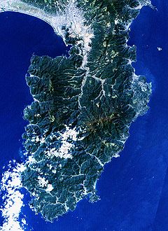
The southern portion of the peninsula is composed largely of breccia
Breccia
Breccia is a rock composed of broken fragments of minerals or rock cemented together by a fine-grained matrix, that can be either similar to or different from the composition of the fragments....
, and the central and northern portions consist of numerous highly eroded volcano
Volcano
2. Bedrock3. Conduit 4. Base5. Sill6. Dike7. Layers of ash emitted by the volcano8. Flank| 9. Layers of lava emitted by the volcano10. Throat11. Parasitic cone12. Lava flow13. Vent14. Crater15...
s. The Amagi Mountain Range dominates the center of the peninsula with Mount Amagi
Mount Amagi
is a range of volcanic mountains in central Izu Peninsula in Shizuoka Prefecture, Japan, forming the border between Izu City and Higashi-Izu Town. It is also referred to as the ....
(1406 m) and Mount Atami (773 m) in the east and Mount Daruma (982 m) in the west, with the eastern and western portions of the range extending underwater into Sagami Bay
Sagami Bay
Sagami Bay , also known as the Sagami Gulf or Sagami Sea, lies south of Kanagawa Prefecture in Honshū, central Japan, contained within the scope of the Miura Peninsula, in Kanagawa, to the east, the Izu Peninsula, in Shizuoka Prefecture, to the west, and the Shōnan coastline to the north, while the...
and Suruga Bay
Suruga Bay
Suruga Bay is a bay on the Pacific coast of Honshū in Shizuoka Prefecture, Japan. It is situated north of an imaginary line joining Omaezaki Point and Irōzaki Point at the tip of the Izu Peninsula and surrounded by Honshū to the southwest and west and the Izu Peninsula to the east.-Geology:Suruga...
. The peninsula's major river, the Kano River
Kano River
The is a 1st class river in Shizuoka Prefecture of cenral Japan. It is 46 km long and has a watershed of 853 km².The Kano River rises from Mount Amagi in central Izu Peninsula and follows a generally northern path into Suruga Bay at Numazu. The Izu Peninsula is characterized by heavy...
in the north, flows through a graben
Graben
In geology, a graben is a depressed block of land bordered by parallel faults. Graben is German for ditch. Graben is used for both the singular and plural....
valley created by plate tectonics.
As a result of its underlying geology, the peninsula is prone to frequent earthquake swarm
Earthquake swarm
Earthquake swarms are events where a local area experiences sequences of many earthquakes striking in a relatively short period of time. The length of time used to define the swarm itself varies, but the United States Geological Survey points out that an event may be on the order of days, weeks, or...
s and tsunami
Tsunami
A tsunami is a series of water waves caused by the displacement of a large volume of a body of water, typically an ocean or a large lake...
s, and it abounds in hot springs
Hot Springs
Hot Springs may refer to:* Hot Springs, Arkansas** Hot Springs National Park, Arkansas*Hot Springs, California**Hot Springs, Lassen County, California**Hot Springs, Modoc County, California**Hot Springs, Placer County, California...
.
Administration
All of Izu Peninsula is within Shizuoka PrefectureShizuoka Prefecture
is a prefecture of Japan located in the Chūbu region on Honshu island. The capital is the city of Shizuoka.- History :Shizuoka prefecture was formed from the former Tōtōmi, Suruga and Izu provinces.The area was the home of the first Tokugawa Shogun...
. It is divided administratively into several cities and towns:
- AtamiAtami, Shizuokais a city located in the eastern end of Shizuoka Prefecture, Japan. As of February 2010, the city has an estimated population of 39,755 and a population density of 645 people per km². The total area is 61.56 km².-Geography:...
- ItōIto, Shizuokais a city located on the eastern shore of the Izu Peninsula in Shizuoka, Japan. As of 2010, the city had an estimated population of 71,400 and the density of 578 persons per km². The total area was...
- IzuIzu, Shizuokais a city located in central Izu Peninsula in Shizuoka, Japan. As of 2009, the city had an estimated population of 35,397 and the density of 97.3 persons per km². The total area as 363.97 km².-Geography:...
- IzunokuniIzunokuni, Shizuokais a city located in Shizuoka Prefecture, Japan. As of 2010, the city has an estimated population of 49,381 and a population density of 521 persons per km². The total area was 94.71 km².-Geography:...
- MishimaMishima, Shizuokais a city located in eastern Shizuoka Prefecture, Japan. As of 2009, the city has an estimated population of 112,078 and a population density of 1,800 persons per km². The total area is 62.13 km²...
- ShimodaShimoda, Shizuokais a city and port in Shizuoka, Japan.As of 2010, the city had an estimated population of 25,054 and a population density of 242 persons per square kilometer...
- Kamo DistrictKamo District, Shizuokais a district located in Shizuoka Prefecture, Japan.The district name is very ancient, and is mentioned in the Engishiki records. Kamo District was one of the original districts of Izu Province, having been separated from Suruga Province along with Tagata District in the cadastral reform of 680 AD...
- HigashiizuHigashiizu, Shizuokais a town located in Kamo District, Shizuoka, Japan. As of 2009, the town has an estimated population of 14,562 and a density of 187 persons per km². The total area is 77.83 km².-Geography:... - Kamo District - KawazuKawazu, Shizuokais a town located on the east coast of Izu Peninsula in Kamo District, Shizuoka, Japan. As of February 2009, the town has an estimated population of 8,074 and a density of 80.1 persons per km². The total area is 100.79 km²...
- Kamo District - MatsuzakiMatsuzaki, Shizuokais a town located in on the southwest coast of Izu Peninsula in Kamo District, Shizuoka, Japan.As of February 2009, the town has an estimated population of 7,709 and a density of 90.4 persons per km². The total area is 85.23 km². Sakuramochi is a noted local speciality.-Geography:Matsuzaki is...
- Kamo District - MinamiizuMinamiizu, Shizuokais a town located at the southern tip of Izu Peninsula in Kamo District, Shizuoka, Japan. As of February 2009, the town has an estimated population of 9,637 and a density of 87.1 persons per km². The total area is 110.58 km².-Geography:...
- Kamo District - NishiizuNishiizu, Shizuokais a town located in Kamo District, Shizuoka, Japan. As of 2009, the town has an estimated population of 9,720 and a density of 92.1 persons per km². The total area is 105.52 km².-Geography:...
Economics
A popular resort region for tourists from the Kantō regionKanto region
The is a geographical area of Honshu, the largest island of Japan. The region includes the Greater Tokyo Area and encompasses seven prefectures: Gunma, Tochigi, Ibaraki, Saitama, Tokyo, Chiba, and Kanagawa. Within its boundaries, slightly more than 40 percent of the land area is the Kantō Plain....
, the Izu peninsula is primarily known for onsen
Onsen
An is a term for hot springs in the Japanese language, though the term is often used to describe the bathing facilities and inns around the hot springs. As a volcanically active country, Japan has thousands of onsen scattered along its length and breadth...
hot spring resorts in Atami, Shuzenji
Izu, Shizuoka
is a city located in central Izu Peninsula in Shizuoka, Japan. As of 2009, the city had an estimated population of 35,397 and the density of 97.3 persons per km². The total area as 363.97 km².-Geography:...
, and Itō. The peninsula abuts Mount Fuji
Mount Fuji
is the highest mountain in Japan at . An active stratovolcano that last erupted in 1707–08, Mount Fuji lies about south-west of Tokyo, and can be seen from there on a clear day. Mount Fuji's exceptionally symmetrical cone is a well-known symbol of Japan and it is frequently depicted in art and...
and is a part of Fuji-Hakone-Izu National Park
Fuji-Hakone-Izu National Park
is a national park in Yamanashi, Shizuoka, and Kanagawa Prefectures, and western Tokyo Metropolis, Japan. It consists of Mount Fuji, Fuji Five Lakes, Hakone, the Izu Peninsula, and the Izu Islands....
. The area is also popular for sea bathing, surfing, golfing and motorcycle touring.
Aside from tourism, agriculture and fishing are the mainstays of the local economy. Izu is one of the biggest producers of wasabi
Wasabi
, also known as Japanese horseradish, is a member of the Brassicaceae family, which includes cabbages, horseradish, and mustard. Its root is used as a condiment and has an extremely strong flavor. Its hotness is more akin to that of a hot mustard rather than the capsaicin in a chili pepper,...
in Japan, and the local cuisine offers dishes flavored with wasabi.
Railway
The Izu peninsula is easily accessible from Tokyo and points west via the Tōkaidō Shinkansen, which has stations in both Atami in the northeast and MishimaMishima, Shizuoka
is a city located in eastern Shizuoka Prefecture, Japan. As of 2009, the city has an estimated population of 112,078 and a population density of 1,800 persons per km². The total area is 62.13 km²...
in the northwest. JR Itō Line and the Izu Kyūkō Line
Izu Kyuko Line
The is a privately owned railway line of Izukyū Corporation in Shizuoka Prefecture, JapanThe line runs along the eastern coast of the Izu Peninsula, a tourist district noted for its numerous hot spring resorts and golf courses, between Itō Station in Itō and Izukyū-Shimoda Station in Shimoda...
provides service along the east coast of the peninsula to Shimoda.
Central Izu is served by the Sunzu Line as far as Shuzenji. The west coast of the peninsula is less developed, and has no train service.
Roadway
Izu Peninsula is served by numerous expressways. By car, it is 103.3 km from the Yōga Interchange (用賀インター Yōga Intā) on the Tokyo end of the Tōmei ExpresswayTomei Expressway
The is a national expressway on the island of Honshū in Japan. It is operated by Central Nippon Expressway Company. It is a part of Asian Highway Network -Naming:The word Tōmei is an acronym consisting of two kanji characters...
to Numazu.
To get to the eastern side, a branch at Atsugi
Atsugi, Kanagawa
is a city located in central Kanagawa Prefecture, Japan. As of 2010, the city has an estimated population of 225,622 and a population density of 2,410 persons per km². The total area was 93.83 km²...
leads to the Odawara-Atsugi Road
Odawara-Atsugi Road
The is a 4-laned toll road in Kanagawa Prefecture, Japan. It is owned and managed by Central Nippon Expressway Company.-Overview:Officially the road is designated as National Route 271...
, which continues past Odawara
Odawara, Kanagawa
is a city located in western Kanagawa Prefecture, Japan. As of 2010, the city had an estimated population of 198,466 with a population density of 1,740 persons per km² . The total area was .-Geography:...
to Yugawara, Atami
Atami, Shizuoka
is a city located in the eastern end of Shizuoka Prefecture, Japan. As of February 2010, the city has an estimated population of 39,755 and a population density of 645 people per km². The total area is 61.56 km².-Geography:...
, and Shimoda. Izu Peninsula is also served by Japan National Route 135, Japan National Route 136, and Japan National Route 414.
The Odakyu Electric Railway
Odakyu Electric Railway
, or OER, is a major railway company based in Tokyo, Japan best known for its Romancecar series of limited express trains from Tokyo to Odawara, Enoshima, Tama New Town, and Hakone....
runs local bus services from Odawara and Hakone, and there is an extensive internal bus network.