
Kamo District, Shizuoka
Encyclopedia

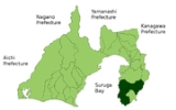
is a district
Districts of Japan
The was most recently used as an administrative unit in Japan between 1878 and 1921 and is roughly equivalent to the county of the United States, ranking at the level below prefecture and above city, town or village. As of 2008, cities belong directly to prefectures and are independent from...
located in Shizuoka Prefecture
Shizuoka Prefecture
is a prefecture of Japan located in the Chūbu region on Honshu island. The capital is the city of Shizuoka.- History :Shizuoka prefecture was formed from the former Tōtōmi, Suruga and Izu provinces.The area was the home of the first Tokugawa Shogun...
, Japan
Japan
Japan is an island nation in East Asia. Located in the Pacific Ocean, it lies to the east of the Sea of Japan, China, North Korea, South Korea and Russia, stretching from the Sea of Okhotsk in the north to the East China Sea and Taiwan in the south...
.
The district name is very ancient, and is mentioned in the Engishiki
Engishiki
-History:In 905 Emperor Daigo ordered the compilation of a new set of laws. Fujiwara no Tokihira began the task, but work stalled when he died four years later in 909. His brother Fujiwara no Tadahira continued the work in 912 eventually completing it in 927...
records. Kamo District was one of the original districts of Izu Province
Izu Province
was a province of Japan in the area of Shizuoka Prefecture. Izu bordered on Sagami and Suruga Provinces. Its abbreviated form name was .The mainland portion of Izu Province, comprising the Izu Peninsula is today the eastern portion of Shizuoka Prefecture and the Izu Islands are now part of...
, having been separated from Suruga Province
Suruga Province
was an old province in the area that is today the central part of Shizuoka prefecture. It was sometimes called . Suruga bordered on Izu, Kai, Sagami, Shinano, and Tōtōmi provinces; and had access to the Pacific Ocean through Suruga Bay.-History:...
along with Tagata District
Tagata District, Shizuoka
is a district located in Shizuoka Prefecture, Japan.Tagata District was one of the original districts of Izu Province, having been separated from Suruga Province in the cadastral reform of 680 AD, and covered most of central Izu Peninsula. By 2009, the district has been considerably reduced in...
in the cadastral reform of 680 AD. During the early Meiji period
Meiji period
The , also known as the Meiji era, is a Japanese era which extended from September 1868 through July 1912. This period represents the first half of the Empire of Japan.- Meiji Restoration and the emperor :...
, the neighboring districts of Naka and Kimisawa were merged into Kamo District. By 2009, the district has been considerably reduced in size, and has an estimated population
Population
A population is all the organisms that both belong to the same group or species and live in the same geographical area. The area that is used to define a sexual population is such that inter-breeding is possible between any pair within the area and more probable than cross-breeding with individuals...
of 49,702 and a density
Population density
Population density is a measurement of population per unit area or unit volume. It is frequently applied to living organisms, and particularly to humans...
of 104 persons per km². The total area is 479.96 km².
The district currently consists of five towns, but originally also included what is now the city of Shimoda
Shimoda, Shizuoka
is a city and port in Shizuoka, Japan.As of 2010, the city had an estimated population of 25,054 and a population density of 242 persons per square kilometer...
.
- HigashiizuHigashiizu, Shizuokais a town located in Kamo District, Shizuoka, Japan. As of 2009, the town has an estimated population of 14,562 and a density of 187 persons per km². The total area is 77.83 km².-Geography:...
- KawazuKawazu, Shizuokais a town located on the east coast of Izu Peninsula in Kamo District, Shizuoka, Japan. As of February 2009, the town has an estimated population of 8,074 and a density of 80.1 persons per km². The total area is 100.79 km²...
- MatsuzakiMatsuzaki, Shizuokais a town located in on the southwest coast of Izu Peninsula in Kamo District, Shizuoka, Japan.As of February 2009, the town has an estimated population of 7,709 and a density of 90.4 persons per km². The total area is 85.23 km². Sakuramochi is a noted local speciality.-Geography:Matsuzaki is...
- MinamiizuMinamiizu, Shizuokais a town located at the southern tip of Izu Peninsula in Kamo District, Shizuoka, Japan. As of February 2009, the town has an estimated population of 9,637 and a density of 87.1 persons per km². The total area is 110.58 km².-Geography:...
- NishiizuNishiizu, Shizuokais a town located in Kamo District, Shizuoka, Japan. As of 2009, the town has an estimated population of 9,720 and a density of 92.1 persons per km². The total area is 105.52 km².-Geography:...
History
- April 1, 1889 - Establishment on municipalities results in creation of Shimoda Town and 26 villages in Kamo District.
- June 11, 1891 - Atami Village becomes Atami TownAtami, Shizuokais a city located in the eastern end of Shizuoka Prefecture, Japan. As of February 2010, the city has an estimated population of 39,755 and a population density of 645 people per km². The total area is 61.56 km².-Geography:...
- April 1, 1894 - Naka District merged into Kamo District; Tagata DistrictTagata District, Shizuokais a district located in Shizuoka Prefecture, Japan.Tagata District was one of the original districts of Izu Province, having been separated from Suruga Province in the cadastral reform of 680 AD, and covered most of central Izu Peninsula. By 2009, the district has been considerably reduced in...
created out of Atami Town and nine northern villages of Kamo District. - March 15, 1901 - Matsuzaka Village becomes Matsuzaki TownMatsuzaki, Shizuokais a town located in on the southwest coast of Izu Peninsula in Kamo District, Shizuoka, Japan.As of February 2009, the town has an estimated population of 7,709 and a density of 90.4 persons per km². The total area is 85.23 km². Sakuramochi is a noted local speciality.-Geography:Matsuzaki is...
- July 7, 1955 - formation of Nishiizu TownNishiizu, Shizuokais a town located in Kamo District, Shizuoka, Japan. As of 2009, the town has an estimated population of 9,720 and a density of 92.1 persons per km². The total area is 105.52 km².-Geography:...
- September 1, 1958 - formation of Kawazu TownKawazu, Shizuokais a town located on the east coast of Izu Peninsula in Kamo District, Shizuoka, Japan. As of February 2009, the town has an estimated population of 8,074 and a density of 80.1 persons per km². The total area is 100.79 km²...
- May 3, 1959 - formation of Higashiizu TownHigashiizu, Shizuokais a town located in Kamo District, Shizuoka, Japan. As of 2009, the town has an estimated population of 14,562 and a density of 187 persons per km². The total area is 77.83 km².-Geography:...
- January 1, 1971 - ShimodaShimoda, Shizuokais a city and port in Shizuoka, Japan.As of 2010, the city had an estimated population of 25,054 and a population density of 242 persons per square kilometer...
gains city status. - April 1, 2005 - Nishiizu TownNishiizu, Shizuokais a town located in Kamo District, Shizuoka, Japan. As of 2009, the town has an estimated population of 9,720 and a density of 92.1 persons per km². The total area is 105.52 km².-Geography:...
and Kamo VillageKamo, Shizuokawas a village located in Kamo District, Shizuoka, Japan.On April 1, 2005 Kamo was incorporated into the neighboring city of Nishiizu.At the time of its merger, the village had an estimated population of 3,291 and a density of 83 persons per km²...
merged to create the town of NishiizuNishiizu, Shizuokais a town located in Kamo District, Shizuoka, Japan. As of 2009, the town has an estimated population of 9,720 and a density of 92.1 persons per km². The total area is 105.52 km².-Geography:...
.
See also
- Kamo District, GifuKamo District, Gifuis a district located in Gifu, Japan.As of Jul, 2011 the district has an estimated population of 52,536. The total area is 615.17 km².-Towns and villages:*Hichisō*Higashishirakawa*Kawabe*Sakahogi*Shirakawa*Tomika*Yaotsu-District Timeline:...
- Higashikamo District, AichiHigashikamo District, Aichiwas a former rural district located in Nishimikawa Region in central Aichi, Japan. The entire district is now part of the city of Toyota.-History:Kamo District was one of the ancient districts of Shinano province, but was transferred to Mikawa province during the Sengoku period...
- Nishikamo District, AichiNishikamo District, Aichiwas a former rural district located in Nishimikawa Region in central Aichi, Japan.-History:Kamo District was one of the ancient districts of Shinano province, but was transferred to Mikawa province during the Sengoku period...
- Kamo District, HiroshimaKamo District, HiroshimaKamo was a district located in Hiroshima Prefecture until 2005. On March 22, 2005 the town of Daiwa merged with the city of Mihara and two towns to form the city of Mihara at which point the district officially ceased to exist...