
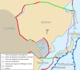
Amurian Plate
Encyclopedia

Manchuria
Manchuria is a historical name given to a large geographic region in northeast Asia. Depending on the definition of its extent, Manchuria usually falls entirely within the People's Republic of China, or is sometimes divided between China and Russia. The region is commonly referred to as Northeast...
, the Korean Peninsula
Korean Peninsula
The Korean Peninsula is a peninsula in East Asia. It extends southwards for about 684 miles from continental Asia into the Pacific Ocean and is surrounded by the Sea of Japan to the south, and the Yellow Sea to the west, the Korea Strait connecting the first two bodies of water.Until the end of...
, Western Japan
Japan
Japan is an island nation in East Asia. Located in the Pacific Ocean, it lies to the east of the Sea of Japan, China, North Korea, South Korea and Russia, stretching from the Sea of Okhotsk in the north to the East China Sea and Taiwan in the south...
, and Primorsky Krai
Primorsky Krai
Primorsky Krai , informally known as Primorye , is a federal subject of Russia . Primorsky means "maritime" in Russian, hence the region is sometimes referred to as Maritime Province or Maritime Territory. Its administrative center is in the city of Vladivostok...
. It is not clear yet whether it is an independent plate or a part of the Eurasian Plate
Eurasian Plate
The Eurasian Plate is a tectonic plate which includes most of the continent of Eurasia , with the notable exceptions of the Indian subcontinent, the Arabian subcontinent, and the area east of the Chersky Range in East Siberia...
.
The Amurian Plate is named after the Amur River, that forms the border between the Russian Far East and Northeastern China.
It is bounded on the north, west, and southwest by the Eurasian Plate
Eurasian Plate
The Eurasian Plate is a tectonic plate which includes most of the continent of Eurasia , with the notable exceptions of the Indian subcontinent, the Arabian subcontinent, and the area east of the Chersky Range in East Siberia...
, on the east by the Okhotsk Plate
Okhotsk Plate
The Okhotsk Plate is a tectonic plate covering the Sea of Okhotsk, the Kamchatka Peninsula, Sakhalin Island and Tōhoku and Hokkaidō in Japan. It was formerly considered a part of the North American Plate, but recent studies indicate that it is an independent plate, bounded on the north by the...
, to the southeast by the Philippine Sea Plate along the Suruga Trough
Suruga Trough
is a trough that lies off the coast of Suruga Bay in Japan, forming part of the Nankai Trough, the latter being responsible the source of many large earthquakes in Japan's history. Both mark the boundary of the Philippine Sea Plate subducting under the Amurian Plate.-See also:* Japan Median...
and the Nankai Trough
Nankai Trough
The Nankai Trough is a submarine trough located south of Japan's island of Honshū, extending approximately 900 km offshore. In plate tectonics, the Nankai Trough marks a subduction zone that is caused by subduction of the Philippine Sea Plate beneath Japan, part of the Eurasian plate...
, and the Okinawa Plate
Okinawa Plate
The Okinawa Plate is a long narrow tectonic plate stretching from the northern end of Taiwan to the southern tip of the island of Kyūshū. To the east lies the Ryukyu Trench and the Pacific Plate. It is separated from the Yangtze Plate by a rift that forms the Okinawa Trough which is a Back arc...
, and the Yangtze Plate
Yangtze Plate
The Yangtze Plate, also called the South China Block or the South China Subplate, comprises the bulk of southern China. It is separated on the east from the Okinawa Plate by a rift that forms the Okinawa Trough which is a Back arc basin, on the south by the Sunda Plate and the Philippine Sea...
.
The Baikal Rift Zone
Baikal Rift Zone
The Baikal Rift Zone is a divergent plate boundary centered beneath Lake Baikal in southeastern Russia. To its west is the Eurasian Plate and to its east is the Amur Plate which is moving away from the rift toward Japan at about 4 mm per year....
is considered a boundary between the Amurian Plate and the Eurasian Plate. GPS measurements indicate that the plate is slowly rotating counter-clockwise.
The Amurian Plate may have been involved in the 1976 Tangshan earthquake
1976 Tangshan earthquake
The Tangshan Earthquake also known as the Great Tangshan Earthquake, was a natural disaster that occurred on July 28, 1976. It is believed to be the largest earthquake of the 20th century by death toll. The epicenter of the earthquake was near Tangshan in Hebei, People's Republic of China, an...
in China.