
Nankai Trough
Encyclopedia
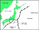
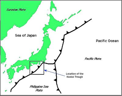
The Nankai Trough is a submarine trough
located south of Japan
's island of Honshū
, extending approximately 900 km offshore. In plate tectonics
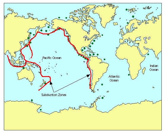
, the Nankai Trough marks a subduction zone that is caused by subduction of the Philippine Sea Plate beneath Japan, part of the Eurasian plate
(Kanda et al., 2004). This plate boundary would be an oceanic trench
except for a high flux of sediments that fills the trench. Within the Nankai Trough there is a large amount of deformed trench sediments (Ike, 2004), making one of Earth's best examples of accretionary prism. Furthermore, seismic reflection studies have revealed the presence of basement highs that are interpreted as seamounts that are covered in sediments (Ike, 2004).
convergent margin were not included. However, using the Eurasia to North America plate motion, the estimated rate was 2-4 mm/yr (DeMets et al., 1990). This is not in agreement with the REVEL model, seemingly indicating that the NUVEL-1A model may need further revision.
-wedge turbidite
s (Spinelli et al., 2007). There are indications of an increase in the retention of porosity within the rock. Typically porosity reduces with increasing depth. However, there is an anomalous preservation of porosity at depth at drill site 1173. This has been attributed to post-depositional opal cementation that is preserving the porosity (Spinelli et al., 2007).
The detrital clays, primarily smectite, display variation over time and location in the Nankai Trough as well as the Shikoku basin. At depth there is an increase in the smectite clay content in the sediments, inferring that there has been a change in the deposition source rock (Steurer et al., 2003). Furthermore, there is a geothermal alteration of the smectite, converting it to illite clay (Steurer et al., 2003).
surfaces along the Nankai Trough. Recently there has been an increase in interest in the release of water from illite clays in subducting sediments. The conversion of smectite to illite (illitizatation) in subduction zones is likely driven by the higher temperature found in the subduction zone as opposed to non-subducting sediments (Saffer et al., 2005).
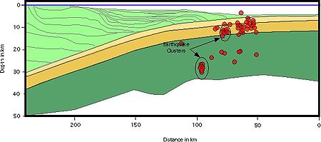 The Nankai Trough is the near-surface extension of a zone of active seismicity that dips beneath SW Japan. The rupture zone has been subdivided into five areas with respect to seismic modelling (Mitsui et al., 2004). These five subdivisions show interesting differences in earthquake
behavior: frequency of earthquakes varying on a 90 to 150 year cycle (Mitsui, et al., 2004; Tanioka et al., 2004), similar slip occurrences along the fault segments, the order of subdivision faulting, and finally, different failure features. Hydrologic observatories were placed in boreholes drilled in 2000 (IODP sites 808 and 1173) in an attempt to quantify changes in pore-fluid pressure that are a result of the oncoming Philippine Sea plate (Davis et al., 2006). Site 808 is located in the front section of the main thrust fault, while site 1173 is located approximately 11 km from the frontal thrust zone (Hitoshi et al., 2006). Other interesting results of the pressure measurements were the pressure changes that resulted from sediment deformation near boreholes and the effect of very low earthquake swarms at the time of pressure changes (Davis et al., 2006). The working hypothesis is that pressure changes indicate a change in the elastic strain within the formation (Davis et al., 2006).
A seaward change in the pressure as measured by the borehole instruments likely indicates a relaxation of the sediments from the previous major thrust earthquake. Furthermore, the short period seismicity appears to have some degree of dependency on bathymetric highs such as seamounts. This was concluded by Kanda et al., 2004, through inversion analysis of seismic data.
Historically, the most recent large-scale earthquake to occur in the Nankai Trough was in 1944 off the Kii Peninsula
. Using recent ocean bottom seismograph studies, it has been determined that most of the seismicity occurs near the trough axis (Obana et al., 2006). Along the western area of the Nankai Trough, seismicity appears to be related to irregularities in crustal structure such as fractures generated from the subducted seafloor, including backarc basin crust of the Shikoku Basin, as well as due to serpentization of uppermost mantle beneath the overriding plate (Obana et al., 2006). Recent large scale earthquakes resulting from subduction along the Nankai Trough have occurred in areas of large scale increases in the dip angle of the subducting plate (Hori et al., 2004).
 At depth in the ocean bottoms, in some cases water can form an ice-like solid structure that has methane trapped in its crystalline lattice, forming gas hydrates. The source of water for the formation of gas hydrates frequently comes from the dewatering of a subducting slab as well as the overriding plate (Muramatsu et al., 2006). Gas hydrates nearest the trough appear to be sourced mainly from dewatering associated with subduction, while with increasing distance from the trough the sourcing is more a result of lateral of methane enriched waters (Muramatsu et al., 2006). This was determined by drilling a series of boreholes and measuring the concentration, as well as radiometric age determination of the halogen elements iodine, bromine, and chlorine (Tomaru et al., 2007). The age determination of the iodine indicated multiple methane sources.
It has been estimated that convergent margins may contain up to two-thirds of the total gas hydrate volume on the earth (Kastner, 2001). The Nankai Trough has been described as containing a large amount of gas hydrates and is one of the best studied sites of gas hydrate formations (Collett, 2002; Saito et al., 2007). The information concerning the gas hydrates in the Nankai Trough was initially published in 2000 by the Japan National Oil Corporations. The data in the news release came from a series of boreholes what were started in the late 1990s. In this area the main sedimentological controls for the accumulation of gas hydrates are the sand-rich areas of the trough (Collett, 2002). Well coring indicates the presence of at least three gas hydrate zones. Krason, 1994, estimated that there are 0.42 to 4.2 x 10^12 cubic meters of methane within the gas hydrates. Seismically, the high bottom simulating reflectors are considered indicative of gas hydrates (Colwell et al., 2004). Methane-rich horizons have been identified as areas of higher attenuation of sonic frequencies (10 to 20 kHz) and only slight attenuation of seismic frequencies (30 to 110 Hz) (Matsushima, 2006).
Trough (geology)
In geology, a trough generally refers to a linear structural depression that extends laterally over a distance, while being less steep than a trench.A trough can be a narrow basin or a geologic rift....
located south of Japan
Japan
Japan is an island nation in East Asia. Located in the Pacific Ocean, it lies to the east of the Sea of Japan, China, North Korea, South Korea and Russia, stretching from the Sea of Okhotsk in the north to the East China Sea and Taiwan in the south...
's island of Honshū
Honshu
is the largest island of Japan. The nation's main island, it is south of Hokkaido across the Tsugaru Strait, north of Shikoku across the Inland Sea, and northeast of Kyushu across the Kanmon Strait...
, extending approximately 900 km offshore. In plate tectonics
Plate tectonics
Plate tectonics is a scientific theory that describes the large scale motions of Earth's lithosphere...
, the Nankai Trough marks a subduction zone that is caused by subduction of the Philippine Sea Plate beneath Japan, part of the Eurasian plate
Eurasian Plate
The Eurasian Plate is a tectonic plate which includes most of the continent of Eurasia , with the notable exceptions of the Indian subcontinent, the Arabian subcontinent, and the area east of the Chersky Range in East Siberia...
(Kanda et al., 2004). This plate boundary would be an oceanic trench
Oceanic trench
The oceanic trenches are hemispheric-scale long but narrow topographic depressions of the sea floor. They are also the deepest parts of the ocean floor....
except for a high flux of sediments that fills the trench. Within the Nankai Trough there is a large amount of deformed trench sediments (Ike, 2004), making one of Earth's best examples of accretionary prism. Furthermore, seismic reflection studies have revealed the presence of basement highs that are interpreted as seamounts that are covered in sediments (Ike, 2004).
Rates of tectonic motion
Conventional geologic estimates of plate movement velocities are difficult in the Nankai Trough because there are no spreading ridges that bound the tectonic plate. This area was not in the original NUVEL models (DeMets et al., 1990). However, a more recent study that included the Philippine Sea plate was based on data from the NUVEL-1A model (Zang et al., 2002). This study estimates that subduction in the Nankai Trough is about 43 mm/yr. REVEL-based calculations indicate that there is no accumulation of strain at the trench. The rates of movement have been calculated to be in a range of 3.0 ± 1.8 mm/yr to 11.1 ± 1.7 mm/yr (Sella et al., 2002). As mentioned previously, the NUVEL-1A plate motion model does not include the Philippine Sea plate. This is because the mathematics of this model only used twelve plates, and the Philippine Sea and EurasianEurasian Plate
The Eurasian Plate is a tectonic plate which includes most of the continent of Eurasia , with the notable exceptions of the Indian subcontinent, the Arabian subcontinent, and the area east of the Chersky Range in East Siberia...
convergent margin were not included. However, using the Eurasia to North America plate motion, the estimated rate was 2-4 mm/yr (DeMets et al., 1990). This is not in agreement with the REVEL model, seemingly indicating that the NUVEL-1A model may need further revision.
Sedimentology
The deposits are primarily trenchTrench
A trench is a type of excavation or depression in the ground. Trenches are generally defined by being deeper than they are wide , and by being narrow compared to their length ....
-wedge turbidite
Turbidite
Turbidite geological formations have their origins in turbidity current deposits, which are deposits from a form of underwater avalanche that are responsible for distributing vast amounts of clastic sediment into the deep ocean.-The ideal turbidite sequence:...
s (Spinelli et al., 2007). There are indications of an increase in the retention of porosity within the rock. Typically porosity reduces with increasing depth. However, there is an anomalous preservation of porosity at depth at drill site 1173. This has been attributed to post-depositional opal cementation that is preserving the porosity (Spinelli et al., 2007).
The detrital clays, primarily smectite, display variation over time and location in the Nankai Trough as well as the Shikoku basin. At depth there is an increase in the smectite clay content in the sediments, inferring that there has been a change in the deposition source rock (Steurer et al., 2003). Furthermore, there is a geothermal alteration of the smectite, converting it to illite clay (Steurer et al., 2003).
Tectonic structure
The Nankai Trough is actively deforming and marks a region of seismic activity. Deformation is concentrated in the outermost imbricate zone, with a significant amount of "out of sequence" thrusting occurring landward. Based on the work of Operta et al., 2006, several areas of intense tectonic activity in the Nankai Trough were identified using full waveform tomography. The upper portion of the upper accretionary prism and the underlying backstop are currently undergoing a great deal of compressional pressure. Several thrust faults were identified by Operta et al., 2006, of which the thrust faults closest to the subduction zone are active. Furthermore, Pisana et al., 2006, identified protothrusts and decollementDecollement
Décollement is a gliding plane between two rock masses. In French, "décoller" means "to detach from" or "to rip off" and was first used by geologists studying the structure of the Swiss Jura Mountains, but is also known as a detachment zone. This is a structure of strata owing to deformation,...
surfaces along the Nankai Trough. Recently there has been an increase in interest in the release of water from illite clays in subducting sediments. The conversion of smectite to illite (illitizatation) in subduction zones is likely driven by the higher temperature found in the subduction zone as opposed to non-subducting sediments (Saffer et al., 2005).
Seismicity
Earthquake
An earthquake is the result of a sudden release of energy in the Earth's crust that creates seismic waves. The seismicity, seismism or seismic activity of an area refers to the frequency, type and size of earthquakes experienced over a period of time...
behavior: frequency of earthquakes varying on a 90 to 150 year cycle (Mitsui, et al., 2004; Tanioka et al., 2004), similar slip occurrences along the fault segments, the order of subdivision faulting, and finally, different failure features. Hydrologic observatories were placed in boreholes drilled in 2000 (IODP sites 808 and 1173) in an attempt to quantify changes in pore-fluid pressure that are a result of the oncoming Philippine Sea plate (Davis et al., 2006). Site 808 is located in the front section of the main thrust fault, while site 1173 is located approximately 11 km from the frontal thrust zone (Hitoshi et al., 2006). Other interesting results of the pressure measurements were the pressure changes that resulted from sediment deformation near boreholes and the effect of very low earthquake swarms at the time of pressure changes (Davis et al., 2006). The working hypothesis is that pressure changes indicate a change in the elastic strain within the formation (Davis et al., 2006).
A seaward change in the pressure as measured by the borehole instruments likely indicates a relaxation of the sediments from the previous major thrust earthquake. Furthermore, the short period seismicity appears to have some degree of dependency on bathymetric highs such as seamounts. This was concluded by Kanda et al., 2004, through inversion analysis of seismic data.
Historically, the most recent large-scale earthquake to occur in the Nankai Trough was in 1944 off the Kii Peninsula
Kii Peninsula
The is the largest peninsula on the island of Honshū in Japan. The area south of the “Central Tectonic Line” is called Nankii , and includes the most poleward living coral reefs in the world due to the presence of the warm Kuroshio Current, though these are threatened by global warming and human...
. Using recent ocean bottom seismograph studies, it has been determined that most of the seismicity occurs near the trough axis (Obana et al., 2006). Along the western area of the Nankai Trough, seismicity appears to be related to irregularities in crustal structure such as fractures generated from the subducted seafloor, including backarc basin crust of the Shikoku Basin, as well as due to serpentization of uppermost mantle beneath the overriding plate (Obana et al., 2006). Recent large scale earthquakes resulting from subduction along the Nankai Trough have occurred in areas of large scale increases in the dip angle of the subducting plate (Hori et al., 2004).
Petroleum significance
It has been estimated that convergent margins may contain up to two-thirds of the total gas hydrate volume on the earth (Kastner, 2001). The Nankai Trough has been described as containing a large amount of gas hydrates and is one of the best studied sites of gas hydrate formations (Collett, 2002; Saito et al., 2007). The information concerning the gas hydrates in the Nankai Trough was initially published in 2000 by the Japan National Oil Corporations. The data in the news release came from a series of boreholes what were started in the late 1990s. In this area the main sedimentological controls for the accumulation of gas hydrates are the sand-rich areas of the trough (Collett, 2002). Well coring indicates the presence of at least three gas hydrate zones. Krason, 1994, estimated that there are 0.42 to 4.2 x 10^12 cubic meters of methane within the gas hydrates. Seismically, the high bottom simulating reflectors are considered indicative of gas hydrates (Colwell et al., 2004). Methane-rich horizons have been identified as areas of higher attenuation of sonic frequencies (10 to 20 kHz) and only slight attenuation of seismic frequencies (30 to 110 Hz) (Matsushima, 2006).
See also
- Nankai megathrust earthquakes
- Nankai Trough gas hydrate siteNankai Trough gas hydrate siteNankai Methane Hydrate Site is located in the Nankai Trough, Japan.- Site highlights :...
- Oceanic trenchOceanic trenchThe oceanic trenches are hemispheric-scale long but narrow topographic depressions of the sea floor. They are also the deepest parts of the ocean floor....
- Subduction Zone
- Philippine Sea Plate
- Suruga TroughSuruga Troughis a trough that lies off the coast of Suruga Bay in Japan, forming part of the Nankai Trough, the latter being responsible the source of many large earthquakes in Japan's history. Both mark the boundary of the Philippine Sea Plate subducting under the Amurian Plate.-See also:* Japan Median...
- Sagami TroughSagami TroughThe also Sagami Trench, Sagami Megathrust, or Sagami Subduction Zone is a 210-mile long trough where the Kanto earthquakes of 1703 , 1855 and 1923 arose. It stretches from the Boso Triple Junction where it meets the Japan Trench to Sagami Bay. It runs north of the Izu Islands chain and the...