
Kanto region
Encyclopedia
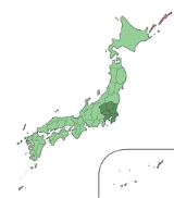
The is a geographical area of Honshu
, the largest island of Japan. The region includes the Greater Tokyo Area
and encompasses seven prefectures
: Gunma
, Tochigi
, Ibaraki
, Saitama
, Tokyo
, Chiba
, and Kanagawa
. Within its boundaries, slightly more than 40 percent of the land area is the Kantō Plain
. The rest consists of the hills and mountains that form the land borders. In official census count on October 1, 2010 by the Japan Statistics Bureau
, the population was 42,607,376 s amounting to approximately one third of the total population of Japan.
and again in the Edo period
, Kantō became the center of modern development. Within the Greater Tokyo Area
and especially the Tokyo-Yokohama
metropolitan area, Kantō houses not only Japan's seat of government but also the nation's largest group of universities and cultural institutions, the greatest population, and a large industrial zone. Although most of the Kantō plain is used for residential, commercial, or industrial construction, it is still farmed. Rice is the principal crop, although the zone around Tokyo and Yokohama has been landscaped to grow garden produce for the metropolitan market.
A watershed moment of Japan's modern history took place in the late Taisho period: the Great Kantō earthquake of 1923. The quake, which claimed more than 100,000 lives and ravaged the Tokyo and Yokohama areas, occurred at a time when Japan was still reeling from the economic recession in reaction to the high-flying years during World War I
.
Operation Coronet, the proposed Allied invasion of Japan during World War II
, was scheduled to land at the Kantō plain. Most of the United States military bases on the island of Honshū
are situated on the Kantō plain. These include Naval Air Facility Atsugi
, Yokota Air Base
, Yokosuka Naval Base
, and Camp Zama
.
The name Kantō literally means "East of the Barrier." The name Kantō is nowadays generally considered to mean the region east (東) of the Hakone checkpoint (関所).
Metropolis (sometimes singulated) and Kanagawa Prefectures. South Kantō is often regarded as synonym
ous with the Greater Tokyo Area
. As part of Japan's attempts to predict eathquakes
, an area roughly corresponding to South Kantō has been designated an 'Area of Intensified Observation' by the Coordinating Committee for Earthquake Prediction
.
The Japanese House of Representatives
' divides it into the electorate which consists of Ibaraki, Tochigi, Gunma and Saitama Prefectures, Tokyo electorate, and the electorate which consists of Chiba, Kanagawa and Yamanashi Prefecture
s. (Note that Yamanashi is out of Kantō region in the orthodox definition.)
uses involving Yamanashi, Nagano and Niigata Prefectures for regional programming and administration.
and Yokohama
form a single industrial complex with a concentration of light and heavy industry along Tokyo Bay
. Other major cities in the area include Kawasaki
(in Kanagawa Prefecture); Saitama
(in Saitama Prefecture); and Chiba
(in Chiba Prefecture). Smaller cities, farther away from the coast, house substantial light and automotive industries. The average population density reached 1,192 persons per square kilometre in 1991.
Honshu
is the largest island of Japan. The nation's main island, it is south of Hokkaido across the Tsugaru Strait, north of Shikoku across the Inland Sea, and northeast of Kyushu across the Kanmon Strait...
, the largest island of Japan. The region includes the Greater Tokyo Area
Greater Tokyo Area
The Greater Tokyo Area is a large metropolitan area in Kantō region, Japan, consisting of most of the prefectures of Chiba, Kanagawa, Saitama, and Tokyo . In Japanese, it is referred to by various terms, including the , , and others....
and encompasses seven prefectures
Prefectures of Japan
The prefectures of Japan are the country's 47 subnational jurisdictions: one "metropolis" , Tokyo; one "circuit" , Hokkaidō; two urban prefectures , Osaka and Kyoto; and 43 other prefectures . In Japanese, they are commonly referred to as...
: Gunma
Gunma Prefecture
is a prefecture of Japan located in the northwest corner of the Kantō region on Honshu island. Its capital is Maebashi.- History :The remains of a Paleolithic man were found at Iwajuku, Gunma Prefecture, in the early 20th century and there is a public museum there.Japan was without horses until...
, Tochigi
Tochigi Prefecture
is a prefecture located in the Kantō region on the island of Honshū, Japan. The capital is the city of Utsunomiya.Nikkō, whose ancient Shintō shrines and Buddhist temples UNESCO has recognized by naming them a World Heritage Site, is in this prefecture...
, Ibaraki
Ibaraki Prefecture
is a prefecture of Japan, located in the Kantō region on the main island of Honshu. The capital is Mito.-History:Ibaraki Prefecture was previously known as Hitachi Province...
, Saitama
Saitama Prefecture
is a prefecture of Japan located in the Kantō region of the island of Honshu. The capital is the city of Saitama.This prefecture is part of the Greater Tokyo Area, and most of Saitama's cities can be described as suburbs of Tokyo, to which a large amount of residents commute each day.- History...
, Tokyo
Tokyo
, ; officially , is one of the 47 prefectures of Japan. Tokyo is the capital of Japan, the center of the Greater Tokyo Area, and the largest metropolitan area of Japan. It is the seat of the Japanese government and the Imperial Palace, and the home of the Japanese Imperial Family...
, Chiba
Chiba Prefecture
is a prefecture of Japan located in the Kantō region and the Greater Tokyo Area. Its capital is Chiba City.- History :Chiba Prefecture was established on June 15, 1873 with the merger of Kisarazu Prefecture and Inba Prefecture...
, and Kanagawa
Kanagawa Prefecture
is a prefecture located in the southern Kantō region of Japan. The capital is Yokohama. Kanagawa is part of the Greater Tokyo Area.-History:The prefecture has some archaeological sites going back to the Jōmon period...
. Within its boundaries, slightly more than 40 percent of the land area is the Kantō Plain
Kanto Plain
The ' is the largest plain in Japan located in the Kanto Region of central Honshū. The total area 17,000 sq km covers more than half of the Region extending over Tokyo, Saitama Prefecture, Kanagawa Prefecture, Chiba Prefecture, Gunma Prefecture, and Tochigi Prefecture.The northern limit borders on...
. The rest consists of the hills and mountains that form the land borders. In official census count on October 1, 2010 by the Japan Statistics Bureau
Demographics of Japan
The demographic features of the population of Japan include population density, ethnicity, education level, health of the populace, economic status, religious affiliations and other aspects of the population....
, the population was 42,607,376 s amounting to approximately one third of the total population of Japan.
History
The heartland of feudal power during the Kamakura periodKamakura period
The is a period of Japanese history that marks the governance by the Kamakura Shogunate, officially established in 1192 in Kamakura by the first shogun Minamoto no Yoritomo....
and again in the Edo period
Edo period
The , or , is a division of Japanese history which was ruled by the shoguns of the Tokugawa family, running from 1603 to 1868. The political entity of this period was the Tokugawa shogunate....
, Kantō became the center of modern development. Within the Greater Tokyo Area
Greater Tokyo Area
The Greater Tokyo Area is a large metropolitan area in Kantō region, Japan, consisting of most of the prefectures of Chiba, Kanagawa, Saitama, and Tokyo . In Japanese, it is referred to by various terms, including the , , and others....
and especially the Tokyo-Yokohama
Yokohama
is the capital city of Kanagawa Prefecture and the second largest city in Japan by population after Tokyo and most populous municipality of Japan. It lies on Tokyo Bay, south of Tokyo, in the Kantō region of the main island of Honshu...
metropolitan area, Kantō houses not only Japan's seat of government but also the nation's largest group of universities and cultural institutions, the greatest population, and a large industrial zone. Although most of the Kantō plain is used for residential, commercial, or industrial construction, it is still farmed. Rice is the principal crop, although the zone around Tokyo and Yokohama has been landscaped to grow garden produce for the metropolitan market.
A watershed moment of Japan's modern history took place in the late Taisho period: the Great Kantō earthquake of 1923. The quake, which claimed more than 100,000 lives and ravaged the Tokyo and Yokohama areas, occurred at a time when Japan was still reeling from the economic recession in reaction to the high-flying years during World War I
World War I
World War I , which was predominantly called the World War or the Great War from its occurrence until 1939, and the First World War or World War I thereafter, was a major war centred in Europe that began on 28 July 1914 and lasted until 11 November 1918...
.
Operation Coronet, the proposed Allied invasion of Japan during World War II
World War II
World War II, or the Second World War , was a global conflict lasting from 1939 to 1945, involving most of the world's nations—including all of the great powers—eventually forming two opposing military alliances: the Allies and the Axis...
, was scheduled to land at the Kantō plain. Most of the United States military bases on the island of Honshū
Honshu
is the largest island of Japan. The nation's main island, it is south of Hokkaido across the Tsugaru Strait, north of Shikoku across the Inland Sea, and northeast of Kyushu across the Kanmon Strait...
are situated on the Kantō plain. These include Naval Air Facility Atsugi
Naval Air Facility Atsugi
is a naval air base located in the cities of Yamato and Ayase in Kanagawa Prefecture, Japan. It is the largest United States Navy air base in the Pacific Ocean and houses the squadrons of Carrier Air Wing 5, which deploys with the aircraft carrier...
, Yokota Air Base
Yokota Air Base
, is a United States Air Force base in the city of Fussa, one of 26 cities in the Tama Area, or Western Tokyo.The base houses 14,000 personnel. The base occupies a total area of and has a runway...
, Yokosuka Naval Base
United States Fleet Activities Yokosuka
U.S. Fleet Activities Yokosuka, or Commander, Fleet Activities Yokosuka is a United States Navy base, in Yokosuka, Japan. Its mission is to maintain and operate base facilities for the logistic, recreational, administrative support and service of the U.S. Naval Forces Japan, U.S. 7th Fleet and...
, and Camp Zama
Camp Zama
is a United States Army post located in the cities of Zama and Sagamihara, in Kanagawa Prefecture, Japan, about southwest of Tokyo.Camp Zama is home to the U.S. Army Japan /I Corps , the U.S. Army Japan Aviation Detachment "Ninjas" , the 500th Military Intelligence Brigade, the Japan Engineer...
.
The name Kantō literally means "East of the Barrier." The name Kantō is nowadays generally considered to mean the region east (東) of the Hakone checkpoint (関所).
North and South
The most often used subdivision of the region is dividing it to consisting of Ibaraki, Tochigi, and Gunma Prefectures and consisting of Saitama (sometimes classified North), Chiba, the TokyoTokyo
, ; officially , is one of the 47 prefectures of Japan. Tokyo is the capital of Japan, the center of the Greater Tokyo Area, and the largest metropolitan area of Japan. It is the seat of the Japanese government and the Imperial Palace, and the home of the Japanese Imperial Family...
Metropolis (sometimes singulated) and Kanagawa Prefectures. South Kantō is often regarded as synonym
Synonym
Synonyms are different words with almost identical or similar meanings. Words that are synonyms are said to be synonymous, and the state of being a synonym is called synonymy. The word comes from Ancient Greek syn and onoma . The words car and automobile are synonyms...
ous with the Greater Tokyo Area
Greater Tokyo Area
The Greater Tokyo Area is a large metropolitan area in Kantō region, Japan, consisting of most of the prefectures of Chiba, Kanagawa, Saitama, and Tokyo . In Japanese, it is referred to by various terms, including the , , and others....
. As part of Japan's attempts to predict eathquakes
Earthquake prediction
An earthquake prediction is a prediction that an earthquake of a specific magnitude will occur in a particular place at a particular time . Despite considerable research efforts by seismologists, scientifically reproducible predictions cannot yet be made to a specific day or month...
, an area roughly corresponding to South Kantō has been designated an 'Area of Intensified Observation' by the Coordinating Committee for Earthquake Prediction
Coordinating Committee for Earthquake Prediction
The Coordinating Committee for Earthquake Prediction in Japan was founded in April 1969, as part of the Geodesy Council's Second Earthquake Prediction Plan, in order to carry out a comprehensive evaluation of earthquake data in Japan. The committee consists of 30 members and meets four times each...
.
The Japanese House of Representatives
House of Representatives of Japan
The is the lower house of the Diet of Japan. The House of Councillors of Japan is the upper house.The House of Representatives has 480 members, elected for a four-year term. Of these, 180 members are elected from 11 multi-member constituencies by a party-list system of proportional representation,...
' divides it into the electorate which consists of Ibaraki, Tochigi, Gunma and Saitama Prefectures, Tokyo electorate, and the electorate which consists of Chiba, Kanagawa and Yamanashi Prefecture
Yamanashi Prefecture
is a prefecture of Japan located in the Chūbu region of the island of Honshū. The capital is the city of Kōfu.-Pre-history to the 14th century:People have been living in the Yamanashi area for about 30,000 years...
s. (Note that Yamanashi is out of Kantō region in the orthodox definition.)
East and West
This division is not often but sometimes used.: Ibaraki, Tochigi and Chiba Prefectures.: Gunma, Saitama, Tokyo, Kanagawa (and sometimes Yamanashi) Prefectures.Inland and Coastal
This division is sometimes used in economics and geography. The border can be modified if the topography is taken for prefectural boundaries.: Tochigi, Gunma, Saitama (and sometimes Yamanashi) Prefectures.: Ibaraki, Chiba, Tokyo and Kanagawa Prefectures.Greater Kantō
The Japanese national government defines the as Kantō region plus Yamanashi Prefecture. Japan's national public broadcaster NHKNHK
NHK is Japan's national public broadcasting organization. NHK, which has always identified itself to its audiences by the English pronunciation of its initials, is a publicly owned corporation funded by viewers' payments of a television license fee....
uses involving Yamanashi, Nagano and Niigata Prefectures for regional programming and administration.
Cities
The Kantō region is the most highly developed, urbanized, and industrialized part of Japan. TokyoTokyo
, ; officially , is one of the 47 prefectures of Japan. Tokyo is the capital of Japan, the center of the Greater Tokyo Area, and the largest metropolitan area of Japan. It is the seat of the Japanese government and the Imperial Palace, and the home of the Japanese Imperial Family...
and Yokohama
Yokohama
is the capital city of Kanagawa Prefecture and the second largest city in Japan by population after Tokyo and most populous municipality of Japan. It lies on Tokyo Bay, south of Tokyo, in the Kantō region of the main island of Honshu...
form a single industrial complex with a concentration of light and heavy industry along Tokyo Bay
Tokyo Bay
is a bay in the southern Kantō region of Japan. Its old name was .-Geography:Tokyo Bay is surrounded by the Bōsō Peninsula to the east and the Miura Peninsula to the west. In a narrow sense, Tokyo Bay is the area north of the straight line formed by the on the Miura Peninsula on one end and on...
. Other major cities in the area include Kawasaki
Kawasaki, Kanagawa
is a city located in Kanagawa Prefecture, Japan, between Tokyo and Yokohama. It is the 9th most populated city in Japan and one of the main cities forming the Greater Tokyo Area and Keihin Industrial Area....
(in Kanagawa Prefecture); Saitama
Saitama, Saitama
' is the capital and the most populous city of Saitama Prefecture in Japan, situated in the south-east of the prefecture. Its area incorporates the former cities of Urawa, Ōmiya, Yono and Iwatsuki. It is a city designated by government ordinance...
(in Saitama Prefecture); and Chiba
Chiba, Chiba
is the capital city of Chiba Prefecture, Japan. It is located approximately 40 km east of the center of Tokyo on Tokyo Bay. Chiba City became a government designated city in 1992. Its population as of 2008 is approximately 960,000....
(in Chiba Prefecture). Smaller cities, farther away from the coast, house substantial light and automotive industries. The average population density reached 1,192 persons per square kilometre in 1991.