
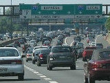
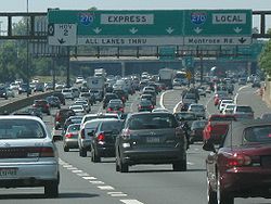
Local-express lanes
Encyclopedia
Carriageway
A carriageway consists of a width of road on which a vehicle is not restricted by any physical barriers or separation to move laterally...
s within a major highway
Highway
A highway is any public road. In American English, the term is common and almost always designates major roads. In British English, the term designates any road open to the public. Any interconnected set of highways can be variously referred to as a "highway system", a "highway network", or a...
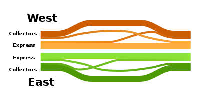
providing one of more roadways for express lanes with a limited number of entrances and exits and also separate roadways for local or collector lane
Lane
A lane is a part of the roadway within a road marked out for use by a single line of vehicles in such a way as to control and guide drivers for the purpose of reducing traffic conflicts. Most public roads have at least two lanes, one for traffic in each direction, separated by Lane markings...
s which provide access to all interchange
Interchange (road)
In the field of road transport, an interchange is a road junction that typically uses grade separation, and one or more ramps, to permit traffic on at least one highway to pass through the junction without directly crossing any other traffic stream. It differs from a standard intersection, at which...
s. Given the considerable overall width of this design new suburban freeways are often designed with interchanges spaced far enough apart to avoid the need for parallel roadways. Where highway ramps between express and local/collector lanes cross over another the result is known as a basketweave
The Basketweave
The Basketweave is the name of a stretch of Highway 401 in Ontario, Canada, immediately east of the Jane Street underpass in Toronto; the name derives from the interesting criss-crossing design of the roads, which evokes imagery of a straw basketweave....
.
United States
- California: Interstate 5Interstate 5Interstate 5 is the main Interstate Highway on the West Coast of the United States, running largely parallel to the Pacific Ocean coastline from Canada to Mexico . It serves some of the largest cities on the U.S...
at the El Toro YEl Toro YThe El Toro "Y" is a freeway interchange in southern Orange County, California where the Santa Ana Freeway, Interstate 5, and the San Diego Freeway, Interstate 405 merge...
in Irvine, CaliforniaIrvine, CaliforniaIrvine is a suburban incorporated city in Orange County, California, United States. It is a planned city, mainly developed by the Irvine Company since the 1960s. Formally incorporated on December 28, 1971, the city has a population of 212,375 as of the 2010 census. However, the California...
and at the "5/805 merge" in Sorrento Valley, San Diego, CaliforniaSorrento Valley, San Diego, CaliforniaSorrento Valley is a neighborhood of San Diego, California. It is located about 15 mi north of Downtown San Diego and its main airport, Lindbergh Field...
. - California: Interstate 10Interstate 10Interstate 10 is the fourth-longest Interstate Highway in the United States, after I-90, I-80, and I-40. It is the southernmost east–west, coast-to-coast Interstate Highway, although I-4 and I-8 are further south. It stretches from the Pacific Ocean at State Route 1 in Santa Monica,...
west of downtown Los AngelesLos ÁngelesLos Ángeles is the capital of the province of Biobío, in the commune of the same name, in Region VIII , in the center-south of Chile. It is located between the Laja and Biobío rivers. The population is 123,445 inhabitants...
in CaliforniaCaliforniaCalifornia is a state located on the West Coast of the United States. It is by far the most populous U.S. state, and the third-largest by land area...
from the Harbor Freeway (Interstate and State Route 110) to Arlington Avenue. - California: Interstate 805Interstate 805Interstate 805 is a major north–south Interstate Highway in Southern California. It is a bypass of Interstate 5, running along the eastern areas of the Greater San Diego area from San Ysidro near the Mexico–U.S...
(northbound only) in Chula Vista, CaliforniaChula Vista, CaliforniaChula Vista is the second largest city in the San Diego metropolitan area, the seventh largest city in Southern California, the fourteenth largest city in the State of California, and the seventy seventh largest city in the U.S....
between the H Street and E Street/Bonita Road exits - California: California State Route 87California State Route 87State Route 87 , locally called Highway 87 or the Guadalupe Freeway, is a north–south state highway entirely within San Jose, California, United States. Its name was changed from Guadalupe Parkway in 2004 after its entire constructed length was upgraded to a freeway...
(Guadalupe Parkway) from Interstate 280Interstate 280 (California)Interstate 280 is a 57-mile long north–south Interstate Highway in the San Francisco Bay Area of Northern California. It connects San Jose and San Francisco, running along just to the west of the cities of San Francisco Peninsula for most of its route.I-280 from its northern end at King...
to Julian Street along Downtown San JoseDowntown San JoseDowntown San Jose is the central business district of San Jose, California, United States. The area is generally located north of Interstate 280 and east of Guadalupe Parkway, which roughly parallels the Guadalupe River. The region is bound to the north by U.S...
(Northbound only) - Florida: I-110 in Pensacola, FloridaPensacola, FloridaPensacola is the westernmost city in the Florida Panhandle and the county seat of Escambia County, Florida, United States of America. As of the 2000 census, the city had a total population of 56,255 and as of 2009, the estimated population was 53,752...
becomes a controlled-access freeway between the Airport Blvd and the Bayou Blvd exits. - Illinois: The Dan Ryan ExpresswayDan Ryan ExpresswayThe Dan Ryan is an expressway in the city of Chicago that runs from the Circle Interchange with I-290 near downtown Chicago through the South Side of the city. It is designated as both Interstate 94 and Interstate 90 south to 66th Street, a distance of...
and Kennedy ExpresswayKennedy ExpresswayThe John F. Kennedy Expressway is a long highway that travels northwest from the Chicago Loop to O'Hare International Airport. The expressway is named for the 35th U.S. President, John F. Kennedy. The Interstate 90 portion of the Kennedy is a part of the much longer I-90...
(Interstates 90Interstate 90Interstate 90 is the longest Interstate Highway in the United States at . It is the northernmost coast-to-coast interstate, and parallels US 20 for the most part. Its western terminus is in Seattle, at Edgar Martinez Drive S. near Safeco Field and CenturyLink Field, and its eastern terminus is in...
and 94Interstate 94Interstate 94 is the northernmost east–west Interstate Highway, connecting the Great Lakes and Intermountain regions of the United States. I-94's western terminus is in Billings, Montana at a junction with Interstate 90; its eastern terminus is the U.S...
in ChicagoChicagoChicago is the largest city in the US state of Illinois. With nearly 2.7 million residents, it is the most populous city in the Midwestern United States and the third most populous in the US, after New York City and Los Angeles...
), between 79th Street and Interstate 55Interstate 55Interstate 55 is an Interstate Highway in the central United States. Its odd number indicates that it is a north–south Interstate Highway. I-55 goes from LaPlace, Louisiana at Interstate 10 to Chicago at U.S. Route 41 , at McCormick Place. A common nickname for the highway is "double...
. - Illinois: Palatine Road between U.S. Route 12U.S. Route 12U.S. Route 12 or US 12 is an east–west United States highway, running from Grays Harbor on the Pacific Ocean, in the state of Washington, to downtown Detroit, for almost . As a thoroughfare, it has mostly been supplanted by I-90 and I-94, but remains an important road for local travel.The...
and Sanders Road through the north suburbs of Chicago has grade-level express lanes, local lanes, and interchanges with the exception of the overpasses at Elmhurst RoadIllinois Route 83Illinois Route 83 is a major north–south state road in northeast Illinois. It stretches from U.S. Highway 30 by Lynwood and Dyer, Indiana north to the Wisconsin border by Antioch at Highway 83. Incidentally, this alignment is concentric with Interstate 294...
and Milwaukee AvenueIllinois Route 21Illinois Route 21 is an arterial north–south state highway in northeastern Illinois. It runs from Illinois Route 43 in Niles to U.S. Route 41 north of Gurnee. Illinois 21 is 28.13 miles long....
and an underpass at Wolf Road. It is not a freeway; instead it is called a "junior expressway". Grade-level intersections require vehicles to execute left hook turnHook turnA hook turn is a traffic-control mechanism where cars that would normally have to turn across oncoming traffic are made to turn across all lanes of traffic instead....
s from the outer local lanes. - Maryland: Interstate 270Interstate 270 (Maryland)Interstate 270 is a auxiliary Interstate Highway in the U.S. state of Maryland that travels between Interstate 495 just north of Bethesda, Montgomery County and Interstate 70 in the city of Frederick in Frederick County. It consists of the mainline as well as a spur that provides access to and...
in Montgomery County, MarylandMontgomery County, MarylandMontgomery County is a county in the U.S. state of Maryland, situated just to the north of Washington, D.C., and southwest of the city of Baltimore. It is one of the most affluent counties in the United States, and has the highest percentage of residents over 25 years of age who hold post-graduate...
(between Montrose Road and Interstate 370Interstate 370Interstate 370 is a Interstate Highway spur route off I-270 in Gaithersburg, Maryland to the western end of toll road MD 200 at an interchange that provides access to the park and ride lot at the Shady Grove station on the Red Line of the Washington Metro. Despite the number, I-370 does not...
) - Michigan: The Jeffries Freeway (I-96) in Detroit.
- Nebraska: Dodge StreetDodge StreetDodge Street is the main east–west street in Omaha, Nebraska. Numbered as U.S. Route 6, the street starts in Downtown Omaha and connects to West Dodge Road around 78th Street. From there it continues westward through the remainder of Douglas County....
(U.S. Route 6U.S. Route 6U.S. Route 6 , also called the Grand Army of the Republic Highway, a name that honors an American Civil War veterans association, is a main route of the U.S. Highway system, running east-northeast from Bishop, California to Provincetown, Massachusetts. Until 1964, it continued south from Bishop to...
) in Omaha, NebraskaOmaha, NebraskaOmaha is the largest city in the state of Nebraska, United States, and is the county seat of Douglas County. It is located in the Midwestern United States on the Missouri River, about 20 miles north of the mouth of the Platte River...
becomes a controlled-access freeway (The West Dodge Freeway) at westbound 93rd Street with elevated local-express lanes that allow drivers to bypass the 114th and 120th Street intersections. The express lanes are known locally as the West Dodge Expressway. - Nevada: Interstate 15Interstate 15Interstate 15 is the fourth-longest north–south Interstate Highway in the United States, traveling through the states of California, Nevada, Arizona, Utah, Idaho, and Montana from San Diego to the Canadian border...
in Las Vegas, NevadaLas Vegas, NevadaLas Vegas is the most populous city in the U.S. state of Nevada and is also the county seat of Clark County, Nevada. Las Vegas is an internationally renowned major resort city for gambling, shopping, and fine dining. The city bills itself as The Entertainment Capital of the World, and is famous...
between Russell Road and Sahara Avenue (opened to traffic October 2009) and between Blue Diamond Road and Russell Road (northbound opened to traffic November 2011 and southbound currently under construction.) - New Jersey: The Garden State ParkwayGarden State ParkwayThe Garden State Parkway is a 172.4-mile limited-access toll parkway that stretches the length of New Jersey from the New York line at Montvale, New Jersey, to Cape May at New Jersey's southernmost tip. Its name refers to New Jersey's nickname, the "Garden State." Most New Jersey residents refer...
in New JerseyNew JerseyNew Jersey is a state in the Northeastern and Middle Atlantic regions of the United States. , its population was 8,791,894. It is bordered on the north and east by the state of New York, on the southeast and south by the Atlantic Ocean, on the west by Pennsylvania and on the southwest by Delaware...
from the Raritan tolls to the Asbury Park tolls. - New Jersey: Interstate 76Interstate 76 (east)Interstate 76 is an Interstate Highway in the United States, running 435 miles from an interchange with Interstate 71 west of Akron, Ohio, east to Interstate 295 near Camden, New Jersey....
in Southern New JerseyNew JerseyNew Jersey is a state in the Northeastern and Middle Atlantic regions of the United States. , its population was 8,791,894. It is bordered on the north and east by the state of New York, on the southeast and south by the Atlantic Ocean, on the west by Pennsylvania and on the southwest by Delaware...
(westbound only) from Interstate 295 to U.S. Highway 130 approaching the Walt Whitman BridgeWalt Whitman BridgeThe Walt Whitman Bridge is a green-colored single-level suspension bridge spanning the Delaware River from Philadelphia to Gloucester City, New Jersey. Named after the poet Walt Whitman, who resided in nearby Camden toward the end of his life, the Walt Whitman Bridge is one of the larger bridges... - New Jersey: Interstate 78Interstate 78Interstate 78 is an Interstate Highway in the Northeast United States, running 144 miles from Interstate 81 northeast of Harrisburg, Pennsylvania, through Allentown, Pennsylvania, and western and northern New Jersey to the Holland Tunnel and Lower Manhattan in New York City.I-78 is a major road...
in Northern New JerseyNew JerseyNew Jersey is a state in the Northeastern and Middle Atlantic regions of the United States. , its population was 8,791,894. It is bordered on the north and east by the state of New York, on the southeast and south by the Atlantic Ocean, on the west by Pennsylvania and on the southwest by Delaware...
(between the New Jersey TurnpikeNew Jersey TurnpikeThe New Jersey Turnpike is a toll road in New Jersey, maintained by the New Jersey Turnpike Authority. According to the International Bridge, Tunnel and Turnpike Association, the Turnpike is the nation's sixth-busiest toll road and is among one of the most heavily traveled highways in the United...
and Route 24Route 24 (New Jersey)Route 24 is a state highway in New Jersey, United States, that extends from a junction with Interstate 287 in Hanover Township in Morris County, passing southeast through Essex County, and ends at a junction with Interstate 78 in Springfield Township in Union County. The route is a four- to...
) - New Jersey: Interstate 80Interstate 80Interstate 80 is the second-longest Interstate Highway in the United States, following Interstate 90. It is a transcontinental artery running from downtown San Francisco, California to Teaneck, New Jersey in the New York City Metropolitan Area...
in Northern New JerseyNew JerseyNew Jersey is a state in the Northeastern and Middle Atlantic regions of the United States. , its population was 8,791,894. It is bordered on the north and east by the state of New York, on the southeast and south by the Atlantic Ocean, on the west by Pennsylvania and on the southwest by Delaware...
(George Washington BridgeGeorge Washington BridgeThe George Washington Bridge is a suspension bridge spanning the Hudson River, connecting the Washington Heights neighborhood in the borough of Manhattan in New York City to Fort Lee, Bergen County, New Jersey. Interstate 95 and U.S. Route 1/9 cross the river via the bridge. U.S...
-Garden State ParkwayGarden State ParkwayThe Garden State Parkway is a 172.4-mile limited-access toll parkway that stretches the length of New Jersey from the New York line at Montvale, New Jersey, to Cape May at New Jersey's southernmost tip. Its name refers to New Jersey's nickname, the "Garden State." Most New Jersey residents refer...
and Interstate 280Interstate 280 (New Jersey)Interstate 280 is a Interstate Highway in the U.S. state of New Jersey. It provides a spur from I-80 in Parsippany-Troy Hills, Morris County to Newark, and I-95 Interstate 280 (abbreviated I-280) is a Interstate Highway in the U.S. state of New Jersey. It provides a spur from I-80 in...
-Interstate 287Interstate 287Interstate 287 is an auxiliary Interstate Highway in the U.S. states of New Jersey and New York. It is a partial beltway around New York City, serving the northern half of New Jersey and the counties of Rockland and Westchester in New York...
) - New Jersey: U.S. Route 1/9U.S. Route 1/9U.S. Route 9 is a U.S. highway in the northeast United States, running from Laurel, Delaware north to the Canadian border near Champlain, New York...
in Northern New JerseyNew JerseyNew Jersey is a state in the Northeastern and Middle Atlantic regions of the United States. , its population was 8,791,894. It is bordered on the north and east by the state of New York, on the southeast and south by the Atlantic Ocean, on the west by Pennsylvania and on the southwest by Delaware...
from Route 81 to US 1/9 Truck) - New Jersey: Route 3 in Northern New Jersey (between the New Jersey TurnpikeNew Jersey TurnpikeThe New Jersey Turnpike is a toll road in New Jersey, maintained by the New Jersey Turnpike Authority. According to the International Bridge, Tunnel and Turnpike Association, the Turnpike is the nation's sixth-busiest toll road and is among one of the most heavily traveled highways in the United...
western spur and New Jersey Route 495) - New Jersey: Interstate 95Interstate 95Interstate 95 is the main highway on the East Coast of the United States, running parallel to the Atlantic Ocean from Maine to Florida and serving some of the most populated urban areas in the country, including Boston, Providence, New Haven, New York City, Newark, Philadelphia, Baltimore,...
from New Jersey Route 32 to The BronxThe BronxThe Bronx is the northernmost of the five boroughs of New York City. It is also known as Bronx County, the last of the 62 counties of New York State to be incorporated...
(Varies from Inner Car Lanes & Outer Truck Lanes to traditional express-local lane setup and upper-level/lower-level on the George Washington BridgeGeorge Washington BridgeThe George Washington Bridge is a suspension bridge spanning the Hudson River, connecting the Washington Heights neighborhood in the borough of Manhattan in New York City to Fort Lee, Bergen County, New Jersey. Interstate 95 and U.S. Route 1/9 cross the river via the bridge. U.S...
). - New Jersey: Interstate 287Interstate 287Interstate 287 is an auxiliary Interstate Highway in the U.S. states of New Jersey and New York. It is a partial beltway around New York City, serving the northern half of New Jersey and the counties of Rockland and Westchester in New York...
in Central/North JerseyNew JerseyNew Jersey is a state in the Northeastern and Middle Atlantic regions of the United States. , its population was 8,791,894. It is bordered on the north and east by the state of New York, on the southeast and south by the Atlantic Ocean, on the west by Pennsylvania and on the southwest by Delaware...
from Interstate 78Interstate 78 in New JerseyInterstate 78 is an east–west route stretching from Union Township, Lebanon County, Pennsylvania to New York City. In New Jersey, I-78 is called the Phillipsburg–Newark Expressway and the Newark Bay Extension of the New Jersey Turnpike...
to U.S. Route 202U.S. Route 202 in New JerseyU.S. Route 202 is a U.S. Highway running from New Castle, Delaware northeast to Bangor, Maine. In the U.S. state of New Jersey, the route runs from the New Hope-Lambertville Toll Bridge over the Delaware River at the Pennsylvania border in Delaware Township, Hunterdon County near Lambertville...
/206U.S. Route 206U.S. Route 206 is a long north–south United States highway in New Jersey and Pennsylvania, United States. Only about a half a mile of its length is in Pennsylvania; the Milford-Montague Toll Bridge carries it over the Delaware River into New Jersey, where it is the remainder of the route... - Ohio: Interstate 271Interstate 271Interstate 271 is an auxiliary interstate highway in the suburbs of Cleveland and Akron in the U.S. state of Ohio. The highway is officially designated the "Cleveland Outerbelt East", but rarely referred to by that name.-Route description:...
in Greater ClevelandGreater ClevelandGreater Cleveland is a nickname for the metropolitan area surrounding Cleveland, Ohio and is part of what used to be the Connecticut Western Reserve.Northeast Ohio refers to a similar but substantially larger area as described below...
between Interstate 480Interstate 480 (Ohio)Interstate 480 is a loop highway that connects the Ohio Turnpike with suburban Cleveland, Ohio. The highway is officially designated the Outerbelt South Freeway, but it is rarely referred to by that name....
in North RandallNorth Randall, OhioNorth Randall is a village in Cuyahoga County, Ohio, United States. The population was 1027 at the 2010 census.-Geography:North Randall is located at ....
and Interstate 90Interstate 90Interstate 90 is the longest Interstate Highway in the United States at . It is the northernmost coast-to-coast interstate, and parallels US 20 for the most part. Its western terminus is in Seattle, at Edgar Martinez Drive S. near Safeco Field and CenturyLink Field, and its eastern terminus is in...
in Willoughby Hills - Pennsylvania: Roosevelt BoulevardRoosevelt Boulevard (Philadelphia)Roosevelt Boulevard , often referred to simply as "the Boulevard," is a major traffic artery through North and Northeast Philadelphia...
(US 1) in Northeast PhiladelphiaNortheast PhiladelphiaNortheast Philadelphia, nicknamed Northeast Philly, the Northeast and the Great Northeast, is a section of the city of Philadelphia, Pennsylvania. According to the 2000 Census, the Northeast has a sizable percentage of the city's 1.547 million people — a population of between 300,000 and 450,000,...
is similarly a surface road with express and local roadways. - Texas: Interstate 35Interstate 35Interstate 35 is a north–south Interstate Highway in the central United States. I-35 stretches from Laredo, Texas, on the U.S.-Mexico border to Duluth, Minnesota, at Minnesota Highway 61 and 26th Avenue East. Many interstates used to have splits or spurs indicated with suffixed letters , but I-35...
, on the northwest corner of Central San Antonio, from near the Exit 158 interchange with Interstate 37Interstate 37Interstate 37 is a intrastate Interstate Highway located within the U.S. state of Texas. The highway was first designated in 1959 as a route between Corpus Christi and San Antonio. Construction in the urban areas of Corpus Christi and San Antonio began in the 1960s and the segments of the...
to the Exit 156 interchange with Interstate 10Interstate 10Interstate 10 is the fourth-longest Interstate Highway in the United States, after I-90, I-80, and I-40. It is the southernmost east–west, coast-to-coast Interstate Highway, although I-4 and I-8 are further south. It stretches from the Pacific Ocean at State Route 1 in Santa Monica,...
. - Texas: Interstate 35Interstate 35Interstate 35 is a north–south Interstate Highway in the central United States. I-35 stretches from Laredo, Texas, on the U.S.-Mexico border to Duluth, Minnesota, at Minnesota Highway 61 and 26th Avenue East. Many interstates used to have splits or spurs indicated with suffixed letters , but I-35...
/Interstate 10Interstate 10Interstate 10 is the fourth-longest Interstate Highway in the United States, after I-90, I-80, and I-40. It is the southernmost east–west, coast-to-coast Interstate Highway, although I-4 and I-8 are further south. It stretches from the Pacific Ocean at State Route 1 in Santa Monica,...
on the southwest corner of Central San Antonio, from near the Exit 155 interchange with TX Spur 536Texas State Highway Spur 536Texas State Highway Spur 536 is a state highway spur in San Antonio, Texas.-Route description:Spur 536 begins at the intersection of US 281 and Loop 410; northbound US 281 follows Loop 410 to the east, while Spur 536 continues north along Roosevelt Avenue through the mission district of San Antonio...
to the Exit 154A interchange with TX Loop 353Texas State Highway Loop 353Loop 353 is a loop route in the U.S. state of Texas that follows a former route of U.S. Highway 81 in San Antonio. Loop 353 follows New Laredo Highway from Interstate 35 on the southwest side of San Antonio towards the northeast and follows Nogalitos Street before ending at another point on...
. - Washington: Interstate 5Interstate 5Interstate 5 is the main Interstate Highway on the West Coast of the United States, running largely parallel to the Pacific Ocean coastline from Canada to Mexico . It serves some of the largest cities on the U.S...
through downtown Seattle, from downtown to Northgate Way. - Washington D.C./Virginia/Maryland: Interstate 495 (Capital Beltway)Interstate 495 (Capital Beltway)Interstate 495 is a Interstate Highway that surrounds the United States' capital of Washington, D.C., and its inner suburbs in adjacent Maryland and Virginia. I-495 is widely known as the Capital Beltway or simply the Beltway, especially when the context of Washington, D.C., is clear...
in the Washington, D.C.Washington, D.C.Washington, D.C., formally the District of Columbia and commonly referred to as Washington, "the District", or simply D.C., is the capital of the United States. On July 16, 1790, the United States Congress approved the creation of a permanent national capital as permitted by the U.S. Constitution....
metro area, between Telegraph Road in Alexandria, VirginiaAlexandria, VirginiaAlexandria is an independent city in the Commonwealth of Virginia. As of 2009, the city had a total population of 139,966. Located along the Western bank of the Potomac River, Alexandria is approximately six miles south of downtown Washington, D.C.Like the rest of northern Virginia, as well as...
and State Route 210 in Oxon Hill, MarylandOxon Hill, MarylandOxon Hill is part of the Oxon Hill-Glassmanor census-designated place in southern Prince George's County, Maryland, United States. Oxon Hill is a suburb of Washington, DC located southeast of the downtown district and east of Alexandria, Virginia...
, as the freeway crosses the Potomac RiverPotomac RiverThe Potomac River flows into the Chesapeake Bay, located along the mid-Atlantic coast of the United States. The river is approximately long, with a drainage area of about 14,700 square miles...
via the Woodrow Wilson BridgeWoodrow Wilson BridgeThe Woodrow Wilson Memorial Bridge is a bascule bridge that spans the Potomac River between the independent city of Alexandria, Virginia and Oxon Hill in Prince George's County, Maryland, United States. While over the water near the Virginia shore, it crosses the southern tip of the District of...
.
Canada
- Gardiner ExpresswayGardiner ExpresswayThe Frederick G. Gardiner Expressway, colloquially referred to as "the Gardiner", is a municipal expressway in the Canadian province of Ontario, connecting downtown Toronto with its western suburbs...
(formerly QEW) from Wickman Road (west of Kipling AvenueKipling AvenueKipling Avenue, originally named Mimico Avenue, is a street in the Etobicoke district of Toronto, Ontario, Canada. It is a concession road, 6 concessions from Yonge Street, and is a major north–south arterial road that also extends beyond Toronto, into the Regional Municipality of York.The...
) to Royal York RoadRoyal York RoadRoyal York Road, historically known as Church Street or New Church Street, is a north-south arterial road in Toronto, Ontario, Canada. It is a concession road, 5 concessions west of Yonge Street, and runs through many residential neighbourhoods, most notably Mimico and the Kingsway...
, in TorontoTorontoToronto is the provincial capital of Ontario and the largest city in Canada. It is located in Southern Ontario on the northwestern shore of Lake Ontario. A relatively modern city, Toronto's history dates back to the late-18th century, when its land was first purchased by the British monarchy from... - Highway 400 in York Region, from the Highway 7Highway 7 (Ontario)King's Highway 7, commonly referred to as Highway 7 and historically as the Northern Highway, is a provincially maintained highway in the Canadian province of Ontario...
interchange to south of Langstaff Road (signed as exit 29 to Highway 7 rather than collector-express)
- Highway 401 in Peel Region, Toronto and Durham Region
- From east of Kennedy Road (Mississauga)—serving the interchange with Highways 410 and 403—to Highway 427
- From east of Kipling Avenue—serving the interchange with Highway 409—to west of Brock Road (Pickering) (Primary system)
- Highway 427 from Queen Elizabeth WayQueen Elizabeth WayThe Queen Elizabeth Way, commonly abbreviated as the QEW, is a 400-Series highway in the Canadian province of Ontario. The freeway links Buffalo, New York and the Niagara Peninsula with Toronto. It begins at the Peace Bridge in Fort Erie and travels around the western shore of Lake Ontario, ending...
/Gardiner ExpresswayGardiner ExpresswayThe Frederick G. Gardiner Expressway, colloquially referred to as "the Gardiner", is a municipal expressway in the Canadian province of Ontario, connecting downtown Toronto with its western suburbs...
to Highway 401 in TorontoTorontoToronto is the provincial capital of Ontario and the largest city in Canada. It is located in Southern Ontario on the northwestern shore of Lake Ontario. A relatively modern city, Toronto's history dates back to the late-18th century, when its land was first purchased by the British monarchy from... - Nova Scotia Highway 118Nova Scotia Highway 118Highway 118, in Nova Scotia, is a short suburban freeway connecting Victoria Road via Woodland Ave. in Dartmouth with Highway 102 at Fall River, to the north. The highway crosses the Historic Shubenacadie Canal. Running parallel to the highway from the Waverley Road to exit 14 is a portion of...
, in Dartmouth, Nova ScotiaDartmouth, Nova ScotiaDartmouth founded in 1750, is a community and planning area of the Halifax Regional Municipality, Nova Scotia. Located on the eastern shore of Halifax Harbour, Dartmouth has been nicknamed the City of Lakes after the large number of lakes located in the city.On April 1, 1996, the provincial...
Other countries
- Third Ring Road, MoscowMoscowMoscow is the capital, the most populous city, and the most populous federal subject of Russia. The city is a major political, economic, cultural, scientific, religious, financial, educational, and transportation centre of Russia and the continent...
, RussiaRussiaRussia or , officially known as both Russia and the Russian Federation , is a country in northern Eurasia. It is a federal semi-presidential republic, comprising 83 federal subjects... - A6 motorway (France), south of Paris
- A2 / N2A2 motorway (Netherlands)The A2 motorway is a motorway in the Netherlands. It is one of the busiest highways in the Netherlands. The road connects the city of Amsterdam, near the interchange Amstel, with the Belgian border, near Maastricht and Liège , and the Belgian road A25....
, sections around Eindhoven, 's-Hertogenbosch, and UtrechtUtrechtUtrecht is a city in the Netherlands.The name may also refer to:* Utrecht , of which Utrecht is the capital* Utrecht , including the city of Utrecht* Bishopric of Utrecht* Roman Catholic Archdiocese of Utrecht...
(all NetherlandsNetherlandsThe Netherlands is a constituent country of the Kingdom of the Netherlands, located mainly in North-West Europe and with several islands in the Caribbean. Mainland Netherlands borders the North Sea to the north and west, Belgium to the south, and Germany to the east, and shares maritime borders...
) - A12A12 motorway (Netherlands)The A12 motorway is a motorway in the Netherlands. The road connects the city of The Hague, with the German border, near Zevenaar, and the German Autobahn BAB 3...
, UtrechtUtrecht (city)Utrecht city and municipality is the capital and most populous city of the Dutch province of Utrecht. It is located in the eastern corner of the Randstad conurbation, and is the fourth largest city of the Netherlands with a population of 312,634 on 1 Jan 2011.Utrecht's ancient city centre features...
, Netherlands - A16A16 motorway (Netherlands)The A16 motorway is a motorway in the Netherlands. It runs from the interchange Terbregseplein in the northeastern part of Rotterdam, towards the Belgian border near Breda.- Speed limit :...
, RotterdamRotterdamRotterdam is the second-largest city in the Netherlands and one of the largest ports in the world. Starting as a dam on the Rotte river, Rotterdam has grown into a major international commercial centre...
, Netherlands - M60 motorwayM60 motorwayThe M60 motorway, or Manchester Orbital, is an orbital motorway circling Greater Manchester, a metropolitan county in North West England. It passes through all Greater Manchester's metropolitan boroughs except for Wigan and Bolton...
, ManchesterManchesterManchester is a city and metropolitan borough in Greater Manchester, England. According to the Office for National Statistics, the 2010 mid-year population estimate for Manchester was 498,800. Manchester lies within one of the UK's largest metropolitan areas, the metropolitan county of Greater...
, EnglandEnglandEngland is a country that is part of the United Kingdom. It shares land borders with Scotland to the north and Wales to the west; the Irish Sea is to the north west, the Celtic Sea to the south west, with the North Sea to the east and the English Channel to the south separating it from continental... - M20 motorwayM20 motorwayThe M20 is a motorway in Kent, England. It runs from the M25 motorway to Folkestone, providing a link to the Channel Tunnel and the ports at Dover. It is long...
, MaidstoneMaidstoneMaidstone is the county town of Kent, England, south-east of London. The River Medway runs through the centre of the town linking Maidstone to Rochester and the Thames Estuary. Historically, the river was a source and route for much of the town's trade. Maidstone was the centre of the agricultural...
, England - M8 motorway, GlasgowGlasgowGlasgow is the largest city in Scotland and third most populous in the United Kingdom. The city is situated on the River Clyde in the country's west central lowlands...
, ScotlandScotlandScotland is a country that is part of the United Kingdom. Occupying the northern third of the island of Great Britain, it shares a border with England to the south and is bounded by the North Sea to the east, the Atlantic Ocean to the north and west, and the North Channel and Irish Sea to the... - A38 roadA38 roadThe A38, part of which is also known as the Devon Expressway, is a major A-class trunk road in England.The road runs from Bodmin in Cornwall to Mansfield in Nottinghamshire. It is long, making it one of the longest A-roads in England. It was formerly known as the Leeds — Exeter Trunk Road,...
, PlymouthPlymouthPlymouth is a city and unitary authority area on the coast of Devon, England, about south-west of London. It is built between the mouths of the rivers Plym to the east and Tamar to the west, where they join Plymouth Sound...
, England - M30 motorwayAutopista de Circunvalación M-30The M-30 orbital motorway circles the central districts of Madrid, the capital city of Spain. It is the innermost ring road of the Spanish city. Outer rings are named M-40, M-45 and M-50....
, MadridMadridMadrid is the capital and largest city of Spain. The population of the city is roughly 3.3 million and the entire population of the Madrid metropolitan area is calculated to be 6.271 million. It is the third largest city in the European Union, after London and Berlin, and its metropolitan...
, SpainSpainSpain , officially the Kingdom of Spain languages]] under the European Charter for Regional or Minority Languages. In each of these, Spain's official name is as follows:;;;;;;), is a country and member state of the European Union located in southwestern Europe on the Iberian Peninsula... - Marginal TieteMarginal TietêMarginal Tietê is a section of this highway that runs through the city of São Paulo, Brazil. The name of this section comes from the fact that each way of the expressway runs near a different waterfront of the Tietê River...
, São PauloSão PauloSão Paulo is the largest city in Brazil, the largest city in the southern hemisphere and South America, and the world's seventh largest city by population. The metropolis is anchor to the São Paulo metropolitan area, ranked as the second-most populous metropolitan area in the Americas and among...
, BrazilBrazilBrazil , officially the Federative Republic of Brazil , is the largest country in South America. It is the world's fifth largest country, both by geographical area and by population with over 192 million people... - Marginal PinheirosMarginal PinheirosMarginal Pinheiros is a section of this highway that runs through the city of São Paulo, Brazil. The name of this section comes from the fact that each way of the expressway runs near a different waterfront of the Pinheiros River...
, São Paulo, Brazil - Via Rápida Poniente y Oriente, TijuanaTijuanaTijuana is the largest city on the Baja California Peninsula and center of the Tijuana metropolitan area, part of the international San Diego–Tijuana metropolitan area. An industrial and financial center of Mexico, Tijuana exerts a strong influence on economics, education, culture, art, and politics...
, MexicoMexicoThe United Mexican States , commonly known as Mexico , is a federal constitutional republic in North America. It is bordered on the north by the United States; on the south and west by the Pacific Ocean; on the southeast by Guatemala, Belize, and the Caribbean Sea; and on the east by the Gulf of... - Between Yenikapı - Bakırköy, Istanbul, Turkey
- M1 West Gate FreewayWest Gate FreewayWest Gate Freeway is a freeway in Melbourne, Australia, linking Geelong to Melbourne CBD and beyond. It is also a link between Melbourne and the west and linking industrial and residential areas west of the Yarra River with the city and port areas. The iconic West Gate Bridge is a part of the...
, between the M2 and Burnley TunnelBurnley TunnelThe Burnley Tunnel is a tollway tunnel in Melbourne, in Victoria, Australia, which carries traffic eastbound from the West Gate Freeway to the Monash Freeway. It is part of the CityLink Tollway operated by Transurban. Running under the Yarra River and the inner suburbs of Richmond and Burnley, the...
in MelbourneMelbourneMelbourne is the capital and most populous city in the state of Victoria, and the second most populous city in Australia. The Melbourne City Centre is the hub of the greater metropolitan area and the Census statistical division—of which "Melbourne" is the common name. As of June 2009, the greater...
, Australia. - Gloucester RoadGloucester Road, Hong KongGloucester Road is a major road in Hong Kong. It is in the north of Wan Chai and East Point on Hong Kong Island. It connects to Harcourt Road at its western end and it ends east along west side of Victoria Park. It forms part of Hong Kong's Route 4 and connects to the Island Eastern Corridor via...
(west-bound from Canal Road West to Fenwick Street), Wan ChaiWan ChaiWan Chai is a metropolitan area situated at the western part of the Wan Chai District on the northern shore of Hong Kong Island, in Hong Kong. Its other boundaries are Canal Road to the east, Arsenal Street to the west and Bowen Road to the south. The area north of Gloucester Road is often called...
, Hong KongHong KongHong Kong is one of two Special Administrative Regions of the People's Republic of China , the other being Macau. A city-state situated on China's south coast and enclosed by the Pearl River Delta and South China Sea, it is renowned for its expansive skyline and deep natural harbour... - Prince Edward Road West (elevated and lower roadway from Pentland Street to Choi Hung Road), KowloonKowloonKowloon is an urban area in Hong Kong comprising the Kowloon Peninsula and New Kowloon. It is bordered by the Lei Yue Mun strait in the east, Mei Foo Sun Chuen and Stonecutter's Island in the west, Tate's Cairn and Lion Rock in the north, and Victoria Harbour in the south. It had a population of...
, Hong Kong - N1 outbound between Koeberg Road and the N7, in Cape TownCape TownCape Town is the second-most populous city in South Africa, and the provincial capital and primate city of the Western Cape. As the seat of the National Parliament, it is also the legislative capital of the country. It forms part of the City of Cape Town metropolitan municipality...
, South Africa - Warringah Freeway Carrying Metroad 1 through North Sydney widens to allow express lanes for the Cahill Expresway and provides access to the harbour Tunnel