
.gif)
County Route 579 (New Jersey)
Encyclopedia
County Route 579, abbreviated CR 579, is a county highway
in the U.S. state
of New Jersey
. The highway extends 37.24 miles (59.9 km) from John Fitch Parkway (Route 29) in Trenton
to Route 173 in Greenwich Township
.
 CR 579 begins at an intersectiuon with Route 29 in Trenton
, Mercer County
, heading north on two-lane undivided Sullivan Way. The road crosses the Delaware and Raritan Canal
and passing under an abandoned railroad and makes a turn to the northwest. The route passes between the Trenton Country Club to the southwest and the Trenton Psychiatric Hospital to the northeast as it enters Ewing Township
. CR 579 enters and crosses CR 643, heading into wooded areas as it passes the Katzenbach School for the Deaf. The route passes under a railroad line that is part of CSX's Trenton Subdivision
and SEPTA's West Trenton Line
near the West Trenton station
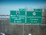
, at which point it becomes Grand Avenue and passes through the residential community of West Trenton
. CR 579 crosses CR 634, becoming Bear Tavern Road, and turns northwest as it passes near Trenton-Mercer Airport
, intersecting CR 600. The route interchanges with I-95
and heads into wooded residential areas, intersecting CR 647 before joining CR 637 on Jacobs Creek Road. Here, the road enters forested areas and crosses the Jacobs Creek into Hopewell Township
, heading north. CR 579 splits from CR 637 and continues northwest onto Bear Tavern Road, crossing the Jacobs Creek again and turning north into a mix of fields, woods, and homes. The route crosses CR 546
and continues through farmland and woodland with a few residences. The route becomes Harbourton-Rocktown Road and comes to a junction with CR 623 before passing through more forested areas and coming to the CR 518
intersection.
 A short distance later, CR 579 continues into West Amwell Township
in Hunterdon County
, continuing through more rural areas of farms, woods, and homes before intersecting Route 31. The two routes run concurrent
to the northwest on the border between West Amwell Township to the west and East Amwell Township
to the east, becoming a three-lane road with a center left-turn lane that crosses entirely into East Amwell Township before resuming along the border of East and West Amwell Townships. The road becomes a divided highway
and crosses entirely into East Amwell Township again before it comes to an interchange with US 202
, where Route 31 heads north along US 202. CR 579 becomes two-lane undivided Linvale-Harbourton Road and heads into the residential community of Ringoes
in East Amwell Township, forming a brief concurrency with Route 179. The route splits from Route 179 at the CR 602 intersection and heads north on John Ringo Road, passing homes and fields before crossing under the Black River and Western Railroad
. The road heads into agricultural areas and intersects CR 604, at which point CR 579 becomes Ringoes-Croton Road and forms the border between East Amwell Township to the west and Raritan Township
to the east before running between Delaware Township to the west and Raritan Township to the east. The road turns more to the northwest as it passes a mix of woods and residential subdivisions, coming to an intersection with CR 523
. CR 579 turns southwest for a brief concurrency with CR 523 before winding northwest again along Ringoes-Croton Road. The road passes a mix of farms, woods, and residential neighborhoods before running north into agricultural areas.
The route crosses Route 12 and continues through rural areas of farms, woods, and homes, entering Franklin Township
. Here, the road runs through open farmland and comes to the CR 616 inersection, where CR 579 turns northwest into the residential community of Quakertown. The road passes more rural residences and farms before turning north at the CR 615 junction and intersecting CR 513
in the community of Pittstown
. CR 579 has a brief concurrency with CR 513, forming the border between Alexandria Township
to the west and Franklin Township to the east. CR 579 splits from CR 513 by heading northwest onto Pittstown-Bloomsbury Road. The road continues along the border between Alexandria Township to the southwest and Union Township
to the northeast through farmland, woodland, and some housing areas, reaching an intersection with CR 625. The road enters more forested surroundings with some homes prior to the CR 614 intersection. A short distance past CR 614, the route becomes the border between Alexandria Township to the southwest and Bethlehem Township
to the northeast, passing some farms and development before heading into forested areas of Musconetcong Mountain
. The road winds across the mountain and fully enters Bethlehem Township. Upon passing over Norfolk Southern's Lehigh Line, CR 579 continues into Bloomsbury
and becomes Church Street. In Bloomsbury, the road passes through residential areas and crosses another railroad line at-grade. After crossing the Musconetcong River
into Greenwich Township
, Warren County
, CR 579 immediately reaches its northern terminus at Route 173.
County highway
A county highway is a road in the United States and in the Canadian province of Ontario that is designated and/or maintained by the county highway department...
in the U.S. state
U.S. state
A U.S. state is any one of the 50 federated states of the United States of America that share sovereignty with the federal government. Because of this shared sovereignty, an American is a citizen both of the federal entity and of his or her state of domicile. Four states use the official title of...
of New Jersey
New Jersey
New Jersey is a state in the Northeastern and Middle Atlantic regions of the United States. , its population was 8,791,894. It is bordered on the north and east by the state of New York, on the southeast and south by the Atlantic Ocean, on the west by Pennsylvania and on the southwest by Delaware...
. The highway extends 37.24 miles (59.9 km) from John Fitch Parkway (Route 29) in Trenton
Trenton, New Jersey
Trenton is the capital of the U.S. state of New Jersey and the county seat of Mercer County. As of the 2010 United States Census, Trenton had a population of 84,913...
to Route 173 in Greenwich Township
Greenwich Township, Warren County, New Jersey
Greenwich Township is a Township in Warren County, New Jersey, United States. As of the United States 2010 Census, the township population was 5,712. The township is located in the far eastern region of the Lehigh Valley....
.
Mercer County
Trenton, New Jersey
Trenton is the capital of the U.S. state of New Jersey and the county seat of Mercer County. As of the 2010 United States Census, Trenton had a population of 84,913...
, Mercer County
Mercer County, New Jersey
As of the census of 2000, there were 350,761 people, 125,807 households, and 86,303 families residing in the county. The population density was 1,552 people per square mile . There were 133,280 housing units at an average density of 590 per square mile...
, heading north on two-lane undivided Sullivan Way. The road crosses the Delaware and Raritan Canal
Delaware and Raritan Canal
The Delaware and Raritan Canal is a canal in central New Jersey, United States, built in the 1830s that served to connect the Delaware River to the Raritan River. It was intended as an efficient and reliable means of transportation of freight between Philadelphia, Pennsylvania and New York City,...
and passing under an abandoned railroad and makes a turn to the northwest. The route passes between the Trenton Country Club to the southwest and the Trenton Psychiatric Hospital to the northeast as it enters Ewing Township
Ewing Township, New Jersey
-Demographics:As of the 2010 Census, there were 35,790 people, 13,171 households, and 7,980 families residing in the township. There were 13,926 housing units. The racial makeup of the township was 63.1% White, 27.6% African American, 0.3% Native American, 4.3% Asian, 0.0% Pacific Islander, 2.2%...
. CR 579 enters and crosses CR 643, heading into wooded areas as it passes the Katzenbach School for the Deaf. The route passes under a railroad line that is part of CSX's Trenton Subdivision
Trenton Subdivision
The Trenton Subdivision is a railroad line owned by CSX Transportation in the U.S. states of Pennsylvania and New Jersey. The line runs from Park Junction in Philadelphia, Pennsylvania northeast to Manville, New Jersey along a former Reading Company line....
and SEPTA's West Trenton Line
West Trenton Line (SEPTA)
The West Trenton Line is a SEPTA Regional Rail line connecting Center City Philadelphia to West Trenton, New Jersey.-Route:The West Trenton Line connects Center City, Philadelphia with the West Trenton section of Ewing, New Jersey...
near the West Trenton station
West Trenton (SEPTA station)
West Trenton is the northern terminus of the SEPTA West Trenton Line. It is officially located at Grand & Railroad Avenues in Ewing, New Jersey, however this address only applies to the southbound station house on the west side of the tracks...
, at which point it becomes Grand Avenue and passes through the residential community of West Trenton
West Trenton, New Jersey
West Trenton, New Jersey is a section of the Trenton suburb of Ewing Township, located just northwest of the capital's city limits.It is home to the New Jersey State Police Headquarters, Trenton-Mercer Airport, Trenton Country Club , New Jersey Manufacturers Insurance Company, The Homasote Company,...
. CR 579 crosses CR 634, becoming Bear Tavern Road, and turns northwest as it passes near Trenton-Mercer Airport
Trenton-Mercer Airport
Trenton-Mercer Airport , formerly known as Mercer County Airport, is a public airport located in Ewing, New Jersey, four miles northwest of the central business district of Trenton, a city in Mercer County, New Jersey...
, intersecting CR 600. The route interchanges with I-95
Interstate 95 in New Jersey
Interstate 95 is a major Interstate Highway that traverses the full extent of the East Coast of the United States, from Florida to Maine...
and heads into wooded residential areas, intersecting CR 647 before joining CR 637 on Jacobs Creek Road. Here, the road enters forested areas and crosses the Jacobs Creek into Hopewell Township
Hopewell Township, Mercer County, New Jersey
As of the 2010 United States Census, the township's population was 17,304. The racial makeup of the township was 86.7% White, 2.1% African American, 0.1% Native American, 8.9% Asian, 0.0% Pacific Islander, 0.5% from other races, and 1.7% from two or more races...
, heading north. CR 579 splits from CR 637 and continues northwest onto Bear Tavern Road, crossing the Jacobs Creek again and turning north into a mix of fields, woods, and homes. The route crosses CR 546
County Route 546 (New Jersey)
County Route 546, abbreviated CR 546, is a county highway in the U.S. state of New Jersey. The highway begins at the Washington Crossing Bridge at Titusville, New Jersey and extends from Route 29 in Hopewell Township to U.S...
and continues through farmland and woodland with a few residences. The route becomes Harbourton-Rocktown Road and comes to a junction with CR 623 before passing through more forested areas and coming to the CR 518
County Route 518 (New Jersey)
County Route 518 is a county highway in the U.S. state of New Jersey. The highway extends from Route 165 in Lambertville to Lincoln Highway in Franklin Township...
intersection.
Hunterdon and Warren counties
West Amwell Township, New Jersey
The Delaware River separates West Amwell from the Commonwealth of Pennsylvania.-Demographics:As of the census of 2000, there were 2,383 people, 949 households, and 696 families residing in the township. The population density was 109.7 people per square mile . There were 984 housing units at an...
in Hunterdon County
Hunterdon County, New Jersey
Hunterdon County is a county located in the western section of the U.S. state of New Jersey. As of the 2010 United States Census, the population was 128,349. It is part of the New York Metropolitan Area. Its county seat is Flemington....
, continuing through more rural areas of farms, woods, and homes before intersecting Route 31. The two routes run concurrent
Concurrency (road)
A concurrency, overlap, or coincidence in a road network is an instance of one physical road bearing two or more different highway, motorway, or other route numbers...
to the northwest on the border between West Amwell Township to the west and East Amwell Township
East Amwell Township, New Jersey
-History:During the American Revolutionary War, a small but important skirmish occurred in East Amwell when local militia under Capt. John Schenck ambushed a party of British dragoons near Larison's Corner...
to the east, becoming a three-lane road with a center left-turn lane that crosses entirely into East Amwell Township before resuming along the border of East and West Amwell Townships. The road becomes a divided highway
Divided Highway
Divided Highway is a compilation album by American rock band The Doobie Brothers, released in 2003. . All tracks are taken from the albums Cycles and Brotherhood .-Track listing:...
and crosses entirely into East Amwell Township again before it comes to an interchange with US 202
U.S. Route 202 in New Jersey
U.S. Route 202 is a U.S. Highway running from New Castle, Delaware northeast to Bangor, Maine. In the U.S. state of New Jersey, the route runs from the New Hope-Lambertville Toll Bridge over the Delaware River at the Pennsylvania border in Delaware Township, Hunterdon County near Lambertville...
, where Route 31 heads north along US 202. CR 579 becomes two-lane undivided Linvale-Harbourton Road and heads into the residential community of Ringoes
Ringoes, New Jersey
Ringoes is an unincorporated area located within East Amwell Township, in Hunterdon County, New Jersey. The community is served by the United States Postal Service as ZIP Code 08551. As of the United States 2000 Census, the population for ZIP Code Tabulation Area 08551 was 5,082.-History:Ringoes is...
in East Amwell Township, forming a brief concurrency with Route 179. The route splits from Route 179 at the CR 602 intersection and heads north on John Ringo Road, passing homes and fields before crossing under the Black River and Western Railroad
Black River and Western Railroad
The Black River and Western Railroad is a short-line railroad operating in Hunterdon County, New Jersey between Flemington and Ringoes. The railroad features vintage steam and diesel powered locomotives...
. The road heads into agricultural areas and intersects CR 604, at which point CR 579 becomes Ringoes-Croton Road and forms the border between East Amwell Township to the west and Raritan Township
Raritan Township, New Jersey
Raritan Township is a Township in Hunterdon County, New Jersey, United States. As of the United States 2010 Census, the township population was 22,185...
to the east before running between Delaware Township to the west and Raritan Township to the east. The road turns more to the northwest as it passes a mix of woods and residential subdivisions, coming to an intersection with CR 523
County Route 523 (New Jersey)
County Route 523 is a county highway in the U.S. state of New Jersey. The highway extends from Main Street in Stockton to Hillside Avenue in Bedminster Township.-Hunterdon County:...
. CR 579 turns southwest for a brief concurrency with CR 523 before winding northwest again along Ringoes-Croton Road. The road passes a mix of farms, woods, and residential neighborhoods before running north into agricultural areas.
The route crosses Route 12 and continues through rural areas of farms, woods, and homes, entering Franklin Township
Franklin Township, Hunterdon County, New Jersey
-Demographics:As of the census of 2000, there were 2,990 people, 1,091 households, and 890 families residing in the township. The population density was 130.7 people per square mile . There were 1,125 housing units at an average density of 49.2 per square mile...
. Here, the road runs through open farmland and comes to the CR 616 inersection, where CR 579 turns northwest into the residential community of Quakertown. The road passes more rural residences and farms before turning north at the CR 615 junction and intersecting CR 513
County Route 513 (New Jersey)
County Route 513 is a county highway in the U.S. state of New Jersey. The highway extends from Kingwood Avenue in Frenchtown to Lakeside Road in West Milford...
in the community of Pittstown
Pittstown, New Jersey
Pittstown is an unincorporated area within portions of Alexandria Township and Franklin Township in Hunterdon County, New Jersey, United States, named after William Pitt. The area is served as United States Postal Service ZIP Code 08867...
. CR 579 has a brief concurrency with CR 513, forming the border between Alexandria Township
Alexandria Township, New Jersey
-Demographics:As of the census of 2000, there were 4,698 people, 1,535 households, and 1,290 families residing in the township. The population density was 170.6 people per square mile . There were 1,598 housing units at an average density of 58.0 per square mile...
to the west and Franklin Township to the east. CR 579 splits from CR 513 by heading northwest onto Pittstown-Bloomsbury Road. The road continues along the border between Alexandria Township to the southwest and Union Township
Union Township, Hunterdon County, New Jersey
-Demographics:As of the census of 2000, there were 6,160 people, 1,666 households, and 1,162 families residing in the township. The population density was 324.8 people per square mile . There were 1,725 housing units at an average density of 90.9 per square mile...
to the northeast through farmland, woodland, and some housing areas, reaching an intersection with CR 625. The road enters more forested surroundings with some homes prior to the CR 614 intersection. A short distance past CR 614, the route becomes the border between Alexandria Township to the southwest and Bethlehem Township
Bethlehem Township, New Jersey
Bethlehem Township falls under the 'Northern New Jersey' climate zone. According to the Office of the New Jersey State Climatologist at Rutgers University, the Northern climate zone covers about one-quarter of New Jersey and consists mainly of elevated highlands and valleys which are part of the...
to the northeast, passing some farms and development before heading into forested areas of Musconetcong Mountain
Musconetcong Mountain
Musconetcong Mountain is a ridge in the Highlands region of New Jersey running south of and parallel to the Musconetcong River. The ridge travels through Alexandria, Holland, Bethlehem and Lebanon Township.-Central Delaware Valley American Viticultural Area:...
. The road winds across the mountain and fully enters Bethlehem Township. Upon passing over Norfolk Southern's Lehigh Line, CR 579 continues into Bloomsbury
Bloomsbury, New Jersey
Bloomsbury is a Borough in Hunterdon County, New Jersey, United States. As of the 2010 United States Census, the borough population was 870.Bloomsbury was incorporated as a borough by an Act of the New Jersey Legislature on March 30, 1905, from portions of Bethlehem Township.The Borough of...
and becomes Church Street. In Bloomsbury, the road passes through residential areas and crosses another railroad line at-grade. After crossing the Musconetcong River
Musconetcong River
The Musconetcong River is a tributary of the Delaware River in northwestern New Jersey in the United States. It flows through the rural mountainous country of northwestern New Jersey. Part of it is a National Wild and Scenic River....
into Greenwich Township
Greenwich Township, Warren County, New Jersey
Greenwich Township is a Township in Warren County, New Jersey, United States. As of the United States 2010 Census, the township population was 5,712. The township is located in the far eastern region of the Lehigh Valley....
, Warren County
Warren County, New Jersey
Warren County is a county located in the U.S. state of New Jersey. As of the 2010 Census, the population was 108,692. Its county seat is Belvidere...
, CR 579 immediately reaches its northern terminus at Route 173.