
Ingleborough
Encyclopedia
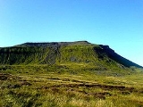
Ingleborough is the second highest mountain in the Yorkshire Dales
. It is one of the Yorkshire Three Peaks
, the other two being Whernside
and Pen-y-ghent
. Ingleborough is frequently climbed as part of the Yorkshire Three Peaks Challenge, which is a 24-mile (38-km) circular challenge walk starting and finishing in Horton in Ribblesdale
. If done anti-clockwise Ingleborough is the last mountain climbed, and ascent is from Chapel-le-Dale
.
word burh
, meaning "a fortified place"; in this case, a hill fort
. On the top of Ingleborough the remains of an old walled enclosure have been discovered inside which foundations of Iron Age
huts have been found.
, being at the highest point of a large triangle of land with corners at Ingleton
, Ribblehead
and Settle
. The hill is connected to its nearest higher neighbour, Whernside, by a low col or mountain pass
at Ribblehead at approximately 296m.
Ingleborough throws out a ridge to the north-east which develops into a summit, Simon Fell
, and another summit further down, Park Fell. An ill-defined ridge going south-east from the summit breaks into two large areas of limestone plateau at about 1300 feet (396.2 m); both plateaux contain summits and these are the subsidiary summits of Norber and Moughton. On the slopes of the former are the famed Norber Boulders. Continuing south-east the high land is broken by a divide which carries the minor road from Austwick
to Helwith Bridge. On the other side of the divide rises the low summit of Smearsett Scar along with its subsidiaries, Pot Scar and Giggleswick Scar; from here the land falls away to the River Ribble
at Settle.
On the western side of Ingleborough is a large limestone plateau appropriately known as White Scars, below which runs the 6.5 kilometres (4 mi) White Scar Caves
, the entrance series of which has been developed as a show cave
. The plateau is bounded by Raven Scar, the longest unbroken cliff in the district, and on top of it is the pothole of Meregill Hole. On the southern side (to the west of the Clapham path) is a similar plateau, this one containing potholes such as Fluted Hole and Pillar Hole.
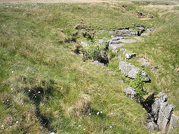 The plateau to the north of Norber, an area known as The Allotment, is particularly rich in potholes; one of these, Long Kin East, can be followed by all and sundry for a distance of 100 yards (91.4 m). Also located here is Juniper Gulf, which descends 420 feet (128 m) underground through an arduous rift, dominated by a small geological fault.
The Smearsett Scar region is not devoid of interesting features either; here can be found the Celtic Wall, the Ebbing and Flowing Well (which has now stopped ebbing and flowing) and a glacial hollow known as the Happy Valley.
routes to its summit. The most frequently-used starting point is probably the village of Ingleton
, which lies about 6 km to the southwest. An ascent from here is about 7.5 miles (12.1 km) there and back. The route follows a walled lane, Fell Lane, before emerging onto a flat area, Crina Bottom, scattered with potholes including the considerable Quaking Pot. A steep climb through the limestone cliffs leads to the summit.
The hill may also be climbed from Horton in Ribblesdale
six miles (10 km) to the east, following a route crossing extensive areas of limestone pavement
in the region of Sulber Nick. This is the route of descent of the Three Peaks Walk and has been heavily improved
by the National Trust after going in just thirty years from no path at all to a serious example of footpath erosion
. Another route on this flank is from the isolated farmstead of Crummack.
There is also a route from Clapham
that follows the Ingleborough Estate nature trail, before passing the Craven Fault
, the showcave of Ingleborough Cave
, the ravine of Trow Gill and the pothole
of Gaping Gill
. It then crosses a marshy area and climbs up to the shoulder of Little Ingleborough before following the ridge to the summit. The return to Clapham can be varied by taking the Horton-in-Ribblesdale path for two miles (3 km) before striking south through more limestone pavement to the small top of Norber; a descent past the famed Norber Boulders finishes a walk of eleven and half miles that Wainwright
considered to be the finest walk in the Yorkshire Dales.
There is a northern route from the Hill Inn at Chapel-le-Dale
, the route of ascent used by the Three Peaks Walk and the shortest way up the mountain, being just 3 miles (4.8 km) from village to summit. An interesting walk across a limestone plateau with many caves, including Great Douk Caves and Meregill Hole, is followed by a steep and tedious climb to the shoulder of the subsidiary summit of Simon Fell
at 2000 feet (609.6 m), a mile to the north-east of the summit. The passage from here to the summit is high-level and exhilarating, but requires some scrambling.
Finally there are unwaymarked routes heading NE across Simon Fell and Souther Scales Fell both of which reach a steep descent just beyond the triangulation pillar on Park Fell to reach the Right of Way at New Close. Both routes give commanding views of the area.
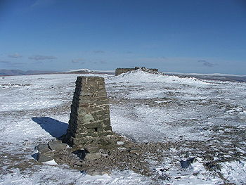 The summit is a broad plateau half a mile in circumference carpeted with dry turf. There is an Ordnance Survey
trig point
(number S. 5619) at the highest point, near the south-western corner. Just to the north is a well-built windshelter with a view indicator or toposcope
built into its centre. Between them is a large cairn
. At the point where the Ingleton path reaches the summit rim is an even larger cairn; this, remarkably, is the remains of a battlemented round tower (a hospice
), built in 1830. The celebrations on the day of its opening ceremony became so alcoholic, however, that parts of it were thrown down there and then, the rest being destroyed later. Along the northern and eastern edges is the shattered wall of a military camp, believed to be Roman
. For the view, which is far-reaching and superb, see here. The hill fort which covers 15 acres (60,702.9 m²) and which the defensive wall can still be seen although much robbed for stone, contains the remains of several stone circle
s. It is now thought that this was in fact Celtic, the Brigantes
tribe the largest tribe in Iron Age Britain a collection of smaller units amalgamated into one tribe. The fort was known to the Romans as the Kings fort. It may be that this was a base for Venutius after his 'divorce' from Cartimandua
the Brigantes Queen who was a supporter of the Roman invaders, unlike Venutius who led several rebellions. What we do know is that this fort was used all year, which was unusual for such a location, but at the time of the Romans the climate was much milder, the Romans for example cultivated grapes in Newcastle.
of the underlying rock. The base of the mountain is composed of ancient Silurian and Ordovician rocks and it is on these that Ingleton stands. A belt of Carboniferous Limestone
, the 'Great Scar Limestone', some 600 feet (182.9 m) thick, lies on top of this. Due to the limestone's permeability
, all the streams flowing down from the mountain are engulfed upon reaching it, falling into a number of potholes. Above lies the layered Yoredale Series of sedimentary rocks, predominantly shale
and sandstone
, and generally concealed by the peat
but revealed in the escarpments about 1700 feet (518.2 m) up. There are also layers of harder limestone sandwiched between the softer rocks which have been eroded faster, and which protect the layers beneath them, leading to the 'tiered' effect. The whole mountain, however, is protected from erosion by a cap of Millstone Grit
, approximately 100 feet (30.5 m) tall. The rock above the Millstone Grit layer has been eroded away, which explains the flatness of the summit.
in degrees
. The furthest peak visible is Manod Mawr
in Snowdonia
, North Wales 103 miles (165.8 km) away on a bearing of 218 degrees.
Yorkshire Dales
The Yorkshire Dales is the name given to an upland area in Northern England.The area lies within the historic county boundaries of Yorkshire, though it spans the ceremonial counties of North Yorkshire, West Yorkshire and Cumbria...
. It is one of the Yorkshire Three Peaks
Yorkshire three peaks
The mountains of Whernside , Ingleborough and Pen-y-ghent are collectively known as the Three Peaks. The peaks, which form part of the...
, the other two being Whernside
Whernside
Whernside is a mountain in the Yorkshire Dales and is one of the Yorkshire Three Peaks, the other two being Ingleborough and Pen-y-ghent. It is the highest point in the ceremonial county of North Yorkshire,Mickle Fell in southern Teesdale is the highest point within the boundaries of the historic...
and Pen-y-ghent
Pen-y-ghent
Pen-y-ghent is a fell in the Yorkshire Dales. It is one of the Yorkshire Three Peaks, the other two being Ingleborough and Whernside. It lies some 3 km east of Horton in Ribblesdale...
. Ingleborough is frequently climbed as part of the Yorkshire Three Peaks Challenge, which is a 24-mile (38-km) circular challenge walk starting and finishing in Horton in Ribblesdale
Horton in Ribblesdale
Horton in Ribblesdale is a small village and civil parish in the Craven district of North Yorkshire, England. It is situated in Ribblesdale on the Settle–Carlisle Railway to the west of Pen-y-ghent....
. If done anti-clockwise Ingleborough is the last mountain climbed, and ascent is from Chapel-le-Dale
Chapel-le-Dale
Chapel-le-Dale is a hamlet in the Yorkshire Dales, England, very near Ribblehead Viaduct. The hamlet is in close proximity to Ingleborough and several potholes, the best known being Great Douk Cave. The source of the River Doe is nearby.-External links:*...
.
Name
The second part of the name Ingleborough is derived from the Old EnglishOld English language
Old English or Anglo-Saxon is an early form of the English language that was spoken and written by the Anglo-Saxons and their descendants in parts of what are now England and southeastern Scotland between at least the mid-5th century and the mid-12th century...
word burh
Burh
A Burh is an Old English name for a fortified town or other defended site, sometimes centred upon a hill fort though always intended as a place of permanent settlement, its origin was in military defence; "it represented only a stage, though a vitally important one, in the evolution of the...
, meaning "a fortified place"; in this case, a hill fort
Hill fort
A hill fort is a type of earthworks used as a fortified refuge or defended settlement, located to exploit a rise in elevation for defensive advantage. They are typically European and of the Bronze and Iron Ages. Some were used in the post-Roman period...
. On the top of Ingleborough the remains of an old walled enclosure have been discovered inside which foundations of Iron Age
British Iron Age
The British Iron Age is a conventional name used in the archaeology of Great Britain, referring to the prehistoric and protohistoric phases of the Iron-Age culture of the main island and the smaller islands, typically excluding prehistoric Ireland, and which had an independent Iron Age culture of...
huts have been found.
Geography
Ingleborough is situated in the south-western corner of the Yorkshire DalesYorkshire Dales
The Yorkshire Dales is the name given to an upland area in Northern England.The area lies within the historic county boundaries of Yorkshire, though it spans the ceremonial counties of North Yorkshire, West Yorkshire and Cumbria...
, being at the highest point of a large triangle of land with corners at Ingleton
Ingleton, North Yorkshire
Ingleton is a village and civil parish in the Yorkshire Dales in North Yorkshire, England. It is famous for walking, hiking and caving. Favourite walks are the Ingleton Waterfalls Trail and the climb up Ingleborough which is one of the famous Three Peaks. Directly from the village visitors can...
, Ribblehead
Ribblehead
Ribblehead is the area of moorland at the head of the River Ribble in the area known as Ribblesdale, in the Yorkshire Dales National Park, England....
and Settle
Settle
Settle is a small market town and civil parish within the Craven district of North Yorkshire, England. It is served by the Settle railway station, which is located near the town centre, and Giggleswick railway station which is a mile away. It is from Leeds Bradford Airport...
. The hill is connected to its nearest higher neighbour, Whernside, by a low col or mountain pass
Mountain pass
A mountain pass is a route through a mountain range or over a ridge. If following the lowest possible route, a pass is locally the highest point on that route...
at Ribblehead at approximately 296m.
Ingleborough throws out a ridge to the north-east which develops into a summit, Simon Fell
Simon Fell (Yorkshire Dales)
Simon Fell is a subsidiary summit on the north east ridge of Ingleborough, a mountain in the Yorkshire Dales in Northern England.With a height of and a prominence of , it is classified as a Hewitt....
, and another summit further down, Park Fell. An ill-defined ridge going south-east from the summit breaks into two large areas of limestone plateau at about 1300 feet (396.2 m); both plateaux contain summits and these are the subsidiary summits of Norber and Moughton. On the slopes of the former are the famed Norber Boulders. Continuing south-east the high land is broken by a divide which carries the minor road from Austwick
Austwick
Austwick is a village and civil parish in the Craven district of North Yorkshire, England, about north west of Settle. The village is on the edge of the Yorkshire Dales National Park....
to Helwith Bridge. On the other side of the divide rises the low summit of Smearsett Scar along with its subsidiaries, Pot Scar and Giggleswick Scar; from here the land falls away to the River Ribble
River Ribble
The River Ribble is a river that runs through North Yorkshire and Lancashire, in northern England. The river's drainage basin also includes parts of Greater Manchester around Wigan.-Geography:...
at Settle.
On the western side of Ingleborough is a large limestone plateau appropriately known as White Scars, below which runs the 6.5 kilometres (4 mi) White Scar Caves
White Scar Caves
White Scar Caves is a network of caves under Ingleborough in the Chapel-le-Dale valley of the Yorkshire Dales National Park in the North of England.Discovered in August 1923 by two amateur geologists, Christopher Long and J.H...
, the entrance series of which has been developed as a show cave
Show cave
Show caves — also called tourist caves, public caves, and in the United States, commercial caves — are caves that are managed by a government or commercial organization and made accessible to the general public, usually for an entrance fee...
. The plateau is bounded by Raven Scar, the longest unbroken cliff in the district, and on top of it is the pothole of Meregill Hole. On the southern side (to the west of the Clapham path) is a similar plateau, this one containing potholes such as Fluted Hole and Pillar Hole.
The Smearsett Scar region is not devoid of interesting features either; here can be found the Celtic Wall, the Ebbing and Flowing Well (which has now stopped ebbing and flowing) and a glacial hollow known as the Happy Valley.
Ascents
There are several popular hillwalkingHillwalking
In the British Isles, the terms hillwalking or fellwalking are commonly used to describe the recreational outdoor activity of walking on hills and mountains, often with the intention of visiting their summits...
routes to its summit. The most frequently-used starting point is probably the village of Ingleton
Ingleton, North Yorkshire
Ingleton is a village and civil parish in the Yorkshire Dales in North Yorkshire, England. It is famous for walking, hiking and caving. Favourite walks are the Ingleton Waterfalls Trail and the climb up Ingleborough which is one of the famous Three Peaks. Directly from the village visitors can...
, which lies about 6 km to the southwest. An ascent from here is about 7.5 miles (12.1 km) there and back. The route follows a walled lane, Fell Lane, before emerging onto a flat area, Crina Bottom, scattered with potholes including the considerable Quaking Pot. A steep climb through the limestone cliffs leads to the summit.
The hill may also be climbed from Horton in Ribblesdale
Horton in Ribblesdale
Horton in Ribblesdale is a small village and civil parish in the Craven district of North Yorkshire, England. It is situated in Ribblesdale on the Settle–Carlisle Railway to the west of Pen-y-ghent....
six miles (10 km) to the east, following a route crossing extensive areas of limestone pavement
Limestone pavement
A limestone pavement is a natural karst landform consisting of a flat, incised surface of exposed limestone that resembles an artificial pavement. The term is mainly used in the UK where many of these landforms have developed distinctive surface patterning resembling block of paving...
in the region of Sulber Nick. This is the route of descent of the Three Peaks Walk and has been heavily improved
Soil conservation
Soil conservation is a set of management strategies for prevention of soil being eroded from the Earth’s surface or becoming chemically altered by overuse, acidification, salinization or other chemical soil contamination...
by the National Trust after going in just thirty years from no path at all to a serious example of footpath erosion
Erosion
Erosion is when materials are removed from the surface and changed into something else. It only works by hydraulic actions and transport of solids in the natural environment, and leads to the deposition of these materials elsewhere...
. Another route on this flank is from the isolated farmstead of Crummack.
There is also a route from Clapham
Clapham, North Yorkshire
Clapham is a village in the Craven district of North Yorkshire, England. It was previously in the West Riding of Yorkshire. It lies within the Yorkshire Dales National Park 6 miles north west of Settle just off the A65.-History:...
that follows the Ingleborough Estate nature trail, before passing the Craven Fault
Craven Fault
The Craven Fault is the name applied by geologists to the group of crustal faults in the Pennines that form the south edge of the Askrigg Block. It is evident at the surface in the contrast of limestone with millstone grit. It is coincident with the south edge of the Yorkshire Dales National Park...
, the showcave of Ingleborough Cave
Ingleborough Cave
Ingleborough Cave is a show cave close to the village of Clapham, North Yorkshire, England adjacent to where the water from Gaping Gill resurges....
, the ravine of Trow Gill and the pothole
Pothole
A pothole is a type of disruption in the surface of a roadway where a portion of the road material has broken away, leaving a hole.- Formation :...
of Gaping Gill
Gaping Gill
Gaping Gill is a natural cave in North Yorkshire, England. It is one of the unmistakable landmarks on the southern slopes of Ingleborough – a deep pothole with the stream Fell Beck flowing into it...
. It then crosses a marshy area and climbs up to the shoulder of Little Ingleborough before following the ridge to the summit. The return to Clapham can be varied by taking the Horton-in-Ribblesdale path for two miles (3 km) before striking south through more limestone pavement to the small top of Norber; a descent past the famed Norber Boulders finishes a walk of eleven and half miles that Wainwright
Alfred Wainwright
Alfred Wainwright MBE was a British fellwalker, guidebook author and illustrator. His seven-volume Pictorial Guide to the Lakeland Fells, published between 1955 and 1966 and consisting entirely of reproductions of his manuscript, has become the standard reference work to 214 of the fells of the...
considered to be the finest walk in the Yorkshire Dales.
There is a northern route from the Hill Inn at Chapel-le-Dale
Chapel-le-Dale
Chapel-le-Dale is a hamlet in the Yorkshire Dales, England, very near Ribblehead Viaduct. The hamlet is in close proximity to Ingleborough and several potholes, the best known being Great Douk Cave. The source of the River Doe is nearby.-External links:*...
, the route of ascent used by the Three Peaks Walk and the shortest way up the mountain, being just 3 miles (4.8 km) from village to summit. An interesting walk across a limestone plateau with many caves, including Great Douk Caves and Meregill Hole, is followed by a steep and tedious climb to the shoulder of the subsidiary summit of Simon Fell
Simon Fell (Yorkshire Dales)
Simon Fell is a subsidiary summit on the north east ridge of Ingleborough, a mountain in the Yorkshire Dales in Northern England.With a height of and a prominence of , it is classified as a Hewitt....
at 2000 feet (609.6 m), a mile to the north-east of the summit. The passage from here to the summit is high-level and exhilarating, but requires some scrambling.
Finally there are unwaymarked routes heading NE across Simon Fell and Souther Scales Fell both of which reach a steep descent just beyond the triangulation pillar on Park Fell to reach the Right of Way at New Close. Both routes give commanding views of the area.
The summit
Ordnance Survey
Ordnance Survey , an executive agency and non-ministerial government department of the Government of the United Kingdom, is the national mapping agency for Great Britain, producing maps of Great Britain , and one of the world's largest producers of maps.The name reflects its creation together with...
trig point
Trig point
A triangulation station, also known as a triangulation pillar, trigonometrical station, trigonometrical point, trig station, trig beacon or trig point, and sometimes informally as a trig, is a fixed surveying station, used in geodetic surveying and other surveying projects in its vicinity...
(number S. 5619) at the highest point, near the south-western corner. Just to the north is a well-built windshelter with a view indicator or toposcope
Toposcope
A toposcope or topograph is a marker erected on hills, mountains or high places which indicates the direction, and usually the distance, to notable landscape features which can be seen from that point...
built into its centre. Between them is a large cairn
Cairn
Cairn is a term used mainly in the English-speaking world for a man-made pile of stones. It comes from the or . Cairns are found all over the world in uplands, on moorland, on mountaintops, near waterways and on sea cliffs, and also in barren desert and tundra areas...
. At the point where the Ingleton path reaches the summit rim is an even larger cairn; this, remarkably, is the remains of a battlemented round tower (a hospice
Hospice
Hospice is a type of care and a philosophy of care which focuses on the palliation of a terminally ill patient's symptoms.In the United States and Canada:*Gentiva Health Services, national provider of hospice and home health services...
), built in 1830. The celebrations on the day of its opening ceremony became so alcoholic, however, that parts of it were thrown down there and then, the rest being destroyed later. Along the northern and eastern edges is the shattered wall of a military camp, believed to be Roman
Roman Britain
Roman Britain was the part of the island of Great Britain controlled by the Roman Empire from AD 43 until ca. AD 410.The Romans referred to the imperial province as Britannia, which eventually comprised all of the island of Great Britain south of the fluid frontier with Caledonia...
. For the view, which is far-reaching and superb, see here. The hill fort which covers 15 acres (60,702.9 m²) and which the defensive wall can still be seen although much robbed for stone, contains the remains of several stone circle
Stone circle
A stone circle is a monument of standing stones arranged in a circle. Such monuments have been constructed across the world throughout history for many different reasons....
s. It is now thought that this was in fact Celtic, the Brigantes
Brigantes
The Brigantes were a Celtic tribe who in pre-Roman times controlled the largest section of what would become Northern England, and a significant part of the Midlands. Their kingdom is sometimes called Brigantia, and it was centred in what was later known as Yorkshire...
tribe the largest tribe in Iron Age Britain a collection of smaller units amalgamated into one tribe. The fort was known to the Romans as the Kings fort. It may be that this was a base for Venutius after his 'divorce' from Cartimandua
Cartimandua
Cartimandua or Cartismandua was a queen of the Brigantes, a Celtic people in what is now Northern England, in the 1st century. She came to power around the time of the Roman conquest of Britain, and formed a large tribal agglomeration that became loyal to Rome...
the Brigantes Queen who was a supporter of the Roman invaders, unlike Venutius who led several rebellions. What we do know is that this fort was used all year, which was unusual for such a location, but at the time of the Romans the climate was much milder, the Romans for example cultivated grapes in Newcastle.
Geology
The striking appearance of Ingleborough from all directions and from a great distance is due to the unusual geologyGeology of Yorkshire
In Yorkshire there is a very close relationship between the major topographical areas and the geological period in which they were formed. The rocks of the Pennine chain of hills in the west are of Carboniferous origin whilst those of the central vale are Permo-Triassic...
of the underlying rock. The base of the mountain is composed of ancient Silurian and Ordovician rocks and it is on these that Ingleton stands. A belt of Carboniferous Limestone
Carboniferous limestone
Carboniferous Limestone is a term used to describe a variety of different types of limestone occurring widely across Great Britain and Ireland which were deposited during the Dinantian epoch of the Carboniferous period. They were formed between 363 and 325 million years ago...
, the 'Great Scar Limestone', some 600 feet (182.9 m) thick, lies on top of this. Due to the limestone's permeability
Permeability (fluid)
Permeability in fluid mechanics and the earth sciences is a measure of the ability of a porous material to allow fluids to pass through it.- Units :...
, all the streams flowing down from the mountain are engulfed upon reaching it, falling into a number of potholes. Above lies the layered Yoredale Series of sedimentary rocks, predominantly shale
Shale
Shale is a fine-grained, clastic sedimentary rock composed of mud that is a mix of flakes of clay minerals and tiny fragments of other minerals, especially quartz and calcite. The ratio of clay to other minerals is variable. Shale is characterized by breaks along thin laminae or parallel layering...
and sandstone
Sandstone
Sandstone is a sedimentary rock composed mainly of sand-sized minerals or rock grains.Most sandstone is composed of quartz and/or feldspar because these are the most common minerals in the Earth's crust. Like sand, sandstone may be any colour, but the most common colours are tan, brown, yellow,...
, and generally concealed by the peat
Peat
Peat is an accumulation of partially decayed vegetation matter or histosol. Peat forms in wetland bogs, moors, muskegs, pocosins, mires, and peat swamp forests. Peat is harvested as an important source of fuel in certain parts of the world...
but revealed in the escarpments about 1700 feet (518.2 m) up. There are also layers of harder limestone sandwiched between the softer rocks which have been eroded faster, and which protect the layers beneath them, leading to the 'tiered' effect. The whole mountain, however, is protected from erosion by a cap of Millstone Grit
Millstone Grit
Millstone Grit is the name given to any of a number of coarse-grained sandstones of Carboniferous age which occur in the Northern England. The name derives from its use in earlier times as a source of millstones for use principally in watermills...
, approximately 100 feet (30.5 m) tall. The rock above the Millstone Grit layer has been eroded away, which explains the flatness of the summit.
The view
Important mountain peaks visible from Ingleborough are listed here, clockwise from north, with their distance in miles and bearingBearing (navigation)
In marine navigation, a bearing is the direction one object is from another object, usually, the direction of an object from one's own vessel. In aircraft navigation, a bearing is the actual compass direction of the forward course of the aircraft...
in degrees
Degree (angle)
A degree , usually denoted by ° , is a measurement of plane angle, representing 1⁄360 of a full rotation; one degree is equivalent to π/180 radians...
. The furthest peak visible is Manod Mawr
Manod Mawr
Manod Mawr is a mountain in North Wales and forms part of the Moelwynion.Although known as a mountain in the eastern Moelwyns, it and its sister peaks are sometimes known as the Ffestiniog hills....
in Snowdonia
Snowdonia
Snowdonia is a region in north Wales and a national park of in area. It was the first to be designated of the three National Parks in Wales, in 1951.-Name and extent:...
, North Wales 103 miles (165.8 km) away on a bearing of 218 degrees.
North
- Wild Boar FellWild Boar FellWild Boar Fell is a mountain in Mallerstang on the eastern edge of Cumbria, England. At , it is either the 4th highest fell in the Yorkshire Dales or the 5th, whether counting nearby High Seat or not...
, 15 miles, 5 degrees - Mickle FellMickle FellMickle Fell is a mountain in the Pennines, the range of hills and moors running down the middle of Northern England. It is 788 m high and lies slightly off the main watershed of the Pennines, about ten miles south of Cross Fell....
, 31 miles, 7 degrees - High Seat, 17 miles, 12 degrees
- Great Knoutberry HillGreat Knoutberry HillGreat Knoutberry Hill, also commonly known as Widdale Fell, is a mountain located near Dent at the heads of Ribblesdale, Dentdale and Wensleydale in the Yorkshire Dales National Park. The Cumbria/North Yorkshire border runs over the fell...
, 8 miles, 21 degrees - Great Shunner FellGreat Shunner FellGreat Shunner Fell is the third highest mountain in the Yorkshire Dales, North Yorkshire, England, and the highest point in Wensleydale; at 716 metres above sea level.The Pennine Way passes over its summit, on the way from Hawes to Keld...
, 16 miles, 26 degrees - Lovely SeatLovely SeatLovely Seat is a fell in the Yorkshire Dales National Park in North Yorkshire, England which reaches a height of 675 metres . It is situated at grid reference five kilometres north of the town of Hawes, and is part of the high ground which separates Wensleydale from Swaledale. It is the highest...
, 15 miles, 34 degrees - Dodd Fell HillDodd Fell HillDodd Fell Hill is a Marilyn in the Yorkshire Dales, in North Yorkshire, England....
, 9 miles, 45 degrees - Yockenthwaite Moor, 11 miles, 69 degrees
- Buckden PikeBuckden PikeBuckden Pike is a mountain at the head of Wharfedale, a valley in the Yorkshire Dales, that stands above the village of Buckden. At , it narrowly misses out on being the highest peak in the area, the title instead going to nearby Great Whernside...
, 14 miles, 79 degrees - Plover HillPlover HillPlover Hill is an area of moorland north of Pen-y-ghent in the Yorkshire Dales, England and connected to it by an unbroken area of high ground. Whilst the area is now on Access Land the main right of way footpaths come directly from the north off Foxup Road and directly from the south from the...
, 7 miles, 87 degrees
East
- Great WhernsideGreat WhernsideGreat Whernside is a mountain in the Yorkshire Dales, England, not to be confused with the better known Whernside, some to the west. Its summit is the highest point of the eastern flank of Wharfedale above Kettlewell...
, 16 miles, 92 degrees - Pen-y-ghentPen-y-ghentPen-y-ghent is a fell in the Yorkshire Dales. It is one of the Yorkshire Three Peaks, the other two being Ingleborough and Whernside. It lies some 3 km east of Horton in Ribblesdale...
, 6 miles, 98 degrees - Fountains FellFountains FellFountains Fell is a mountain in the Yorkshire Dales, England. The main summit has a height of and a relative height or topographic prominence of and thus qualifies as a Marilyn. Its subsidiary south top reaches and qualifies as a Nuttall...
, 8 miles, 105 degrees - Thorpe Fell TopThorpe Fell TopThorpe Fell Top is the top of the hill of Burnsall and Thorpe Fell in the Yorkshire Dales, itself forming part of a larger wedge of ground between Wharfedale and Skipton....
, 19 miles, 119 degrees - Ilkley MoorIlkley MoorIlkley Moor is part of Rombalds Moor, the moorland between Ilkley and Keighley in West Yorkshire, England, United Kingdom. The peat bogs rise to 402 m above sea level...
, 30 miles, 128 degrees - Rye Loaf Hill, 10 miles, 132 degrees
- Boulsworth HillBoulsworth HillBoulsworth Hill is a large expanse of moorland, the highest point of the South Pennines of south-eastern Lancashire, England, separating the District of Pendle from Calderdale....
, 27 miles, 155 degrees - Kinder ScoutKinder ScoutKinder Scout is a moorland plateau in the Dark Peak of the Derbyshire Peak District in England. Part of the moor, at 636 m above sea level, is the highest point in the Peak District, the highest point in Derbyshire, and the highest point in the East Midlands. It is accessible from the villages of...
, 58 miles, 159 degrees - Shining TorShining TorShining Tor is a hill in the Peak District of England, between the towns of Buxton and Macclesfield, lying on the border between Derbyshire and Cheshire. Its summit is the highest point in Cheshire...
, 65 miles, 166 degrees - Pendle HillPendle HillPendle Hill is located in the north-east of Lancashire, England, near the towns of Burnley, Nelson, Colne, Clitheroe and Padiham, an area known as Pendleside. Its summit is above mean sea level. It gives its name to the Borough of Pendle. It is an isolated hill, separated from the Pennines to the...
, 21 miles, 169 degrees
South
- Winter Hill, 38 miles, 188 degrees
- White Hill, 11 miles, 203 degrees
- Fair Snape FellFair Snape FellFair Snape Fell is one of the larger hills in the Forest of Bowland in Lancashire, England. It occupies a position in the very south of the main range of fells, alongside and just to the north of Parlick, joined by a ridge...
, 19 miles, 208 degrees - Moel SiabodMoel SiabodMoel Siabod is a mountain in Snowdonia, North Wales, which sits isolated above the villages of Betws-y-Coed and Capel Curig. At 872m it is the highest peak in the Moelwynion mountain range. The UK National Mountain Centre, Plas-y-Brenin, is located at the foot of Moel Siabod...
, 99 miles, 221 degrees - Ward's StoneWard's StoneWard's Stone is the highest hill in the Forest of Bowland. Its flat top hides two trig points nearly a kilometre apart. The western trig point sits atop of large rocks, including one, the Ward's Stone, that is so large it attracts boulderers and climbers....
, 13 miles, 223 degrees - Carnedd LlewelynCarnedd LlewelynCarnedd Llewelyn, usually spelt Carnedd Llywelyn in Welsh, is a mountain massif in the Carneddau range in Snowdonia, north-west Wales...
, 95 miles, 224 degrees - Caton Moor, 12 miles, 236 degrees
- Warton Crag, 15 miles, 266 degrees
West
- SnaefellSnaefellSnaefell is the highest mountain and the only summit higher than on the Isle of Man, at above sea level. The summit is crowned by a train station, cafe, and several communications masts.- Views :...
, 84 miles, 275 degrees - Black CombeBlack CombeBlack Combe is a fell in the south-west corner of the Lake District National Park, just four miles from the Irish Sea. It lies near the west coast of Cumbria in the borough of Copeland and more specifically, an area known as South Copeland...
, 38 miles, 280 degrees - Old Man of ConistonOld Man of ConistonThe Old Man of Coniston is a fell in the Furness Fells in the English Lake District. It is high, and lies to the west of the village of Coniston and the lake of the same name, Coniston Water. The fell is sometimes known by the alternate name of Coniston Old Man, or simply The Old Man...
, 33 miles, 296 degrees - Scafell PikeScafell PikeScafell Pike is the highest mountain in England at . It is located in Lake District National Park sometimes confused with the neighbouring Sca Fell, to which it is connected by the col of Mickledore...
, 38 miles, 302 degrees - Great GableGreat GableGreat Gable is a mountain lying at the very heart of the English Lake District, appearing as a pyramid from Wasdale , but as a dome from most other directions. It is one of the most popular of the Lakeland fells, and there are many different routes to the summit...
, 40 miles, 304 degrees - GrasmoorGrasmoorGrasmoor is a mountain in the north-western part of the Lake District, northern England. It is the highest peak in a group of hills between the villages of Lorton, Braithwaite and Buttermere, and overlooks Crummock Water....
, 45 miles, 309 degrees - HelvellynHelvellynHelvellyn is a mountain in the English Lake District, the apex of the Eastern Fells. At above sea level, it is the third highest peak in both the Lake District and England...
, 35 miles, 315 degrees - High StreetHigh Street (Lake District)High Street is a fell in the English Lake District. At 828 metres , its summit is the highest point in the far eastern part of the national park. The fell is named after the Roman road which ran over the summit.-History and Naming:...
, 29 miles, 321 degrees - Great CoumGreat CoumGreat Coum is a hill in the Yorkshire Dales. Despite this it actually lies in Cumbria.Its neighbours include Crag Hill, Green Hill and Gragareth....
, 6 miles, 337 degrees - The CalfThe CalfThe Calf, at 676 m, is the highest top in the Howgill Fells, an area of high ground in the north-west of the Yorkshire Dales in the county of Cumbria. It can be ascended from the town of Sedbergh to the south, by way of Cautley Spout from the east, or up the long valley of Langdale from the...
, 15 miles, 342 degrees - YarlsideYarlsideYarlside is a hill in the Howgill Fells, Cumbria, England....
, 15 miles, 347 degrees - Cross FellCross FellCross Fell is the highest point in the Pennine Hills of northern England and the highest point in England outside of the Lake District.The summit, at , is a stony plateau, part of a long ridge running North West to South East, which also incorporates Little Dun Fell at and Great Dun Fell at...
, 37 miles, 355 degrees - WhernsideWhernsideWhernside is a mountain in the Yorkshire Dales and is one of the Yorkshire Three Peaks, the other two being Ingleborough and Pen-y-ghent. It is the highest point in the ceremonial county of North Yorkshire,Mickle Fell in southern Teesdale is the highest point within the boundaries of the historic...
, 4 miles, 359 degrees