
Ingleton, North Yorkshire
Encyclopedia
Ingleton is a village and civil parish
in the Yorkshire Dales
in North Yorkshire
, England. It is famous for walking, hiking and caving. Favourite walks are the Ingleton Waterfalls Trail
and the climb up Ingleborough
which is one of the famous Three Peaks
. Directly from the village visitors can ascend the 2373 feet (723.3 m) of Ingleborough and take in a view of the Yorkshire Dales from its summit. The more experienced try the Three Peaks Challenge
, with Ingleborough, Whernside
and Pen-y-ghent
offering 25 miles (40.2 km) of outstanding natural beauty. The River Doe
and the River Twiss
join together in the town to form the source of the River Greta
, which flows into nearby Lancashire
.
Throughout history, the Romans
, Celts, Vikings and Normans
have left their mark on Ingleton and its surrounding area. Set against a backdrop of wooded valleys and cave
s, the village nestles at the foot of Ingleborough - probably the most easily recognised of the Three Peaks. Full of character and fascinating history, Ingleton is a thriving tourist attraction
. Nearby are the White Scar Caves
and Ingleborough Cave
, show-caves popular with tourists and Gaping Gill
, whose 365 ft (111.3 m) cavern can be visited by tourists on spring and autumn bank holiday
s when a winch is set up. For more experienced cavers, the area has a labyrinth
of challenging pothole
s and caves. This is due to the 300 million year old limestone
rock of the area, which has gradually been dissolved by groundwater.
Ingleton Primary and Ingleton Middle School are the village schools, which are followed by Settle College.
In 1933 an open-air swimming pool
was dug out and built by local volunteers. The European (Objective 5b) Community Fund, the National Lottery and private donations have been used recently to improve and modernize the pool.
The hamlet
of Yarlsber lies south-east of Ingleton.
Civil parish
In England, a civil parish is a territorial designation and, where they are found, the lowest tier of local government below districts and counties...
in the Yorkshire Dales
Yorkshire Dales
The Yorkshire Dales is the name given to an upland area in Northern England.The area lies within the historic county boundaries of Yorkshire, though it spans the ceremonial counties of North Yorkshire, West Yorkshire and Cumbria...
in North Yorkshire
North Yorkshire
North Yorkshire is a non-metropolitan or shire county located in the Yorkshire and the Humber region of England, and a ceremonial county primarily in that region but partly in North East England. Created in 1974 by the Local Government Act 1972 it covers an area of , making it the largest...
, England. It is famous for walking, hiking and caving. Favourite walks are the Ingleton Waterfalls Trail
Ingleton Waterfalls Trail
Ingleton Waterfalls Trail is a well-known circular trail beginning and ending in the village of Ingleton in the English county of North Yorkshire, now maintained by the Ingleton Scenery Company...
and the climb up Ingleborough
Ingleborough
Ingleborough is the second highest mountain in the Yorkshire Dales. It is one of the Yorkshire Three Peaks, the other two being Whernside and Pen-y-ghent. Ingleborough is frequently climbed as part of the Yorkshire Three Peaks Challenge, which is a 24-mile circular challenge walk starting and...
which is one of the famous Three Peaks
Yorkshire three peaks
The mountains of Whernside , Ingleborough and Pen-y-ghent are collectively known as the Three Peaks. The peaks, which form part of the...
. Directly from the village visitors can ascend the 2373 feet (723.3 m) of Ingleborough and take in a view of the Yorkshire Dales from its summit. The more experienced try the Three Peaks Challenge
Three Peaks Challenge
Three Peaks may refer to:* National Three Peaks Challenge, a mountain endurance challenge in Great Britain* Three Peaks yacht race, a yacht race in the United Kingdom...
, with Ingleborough, Whernside
Whernside
Whernside is a mountain in the Yorkshire Dales and is one of the Yorkshire Three Peaks, the other two being Ingleborough and Pen-y-ghent. It is the highest point in the ceremonial county of North Yorkshire,Mickle Fell in southern Teesdale is the highest point within the boundaries of the historic...
and Pen-y-ghent
Pen-y-ghent
Pen-y-ghent is a fell in the Yorkshire Dales. It is one of the Yorkshire Three Peaks, the other two being Ingleborough and Whernside. It lies some 3 km east of Horton in Ribblesdale...
offering 25 miles (40.2 km) of outstanding natural beauty. The River Doe
River Doe
The River Doe is a river in North Yorkshire, England.The river emerges near God's Bridge close to the settlement of Chapel-le-Dale and flows through Twisleton in a southwesterly direction to Ingleton, where it meets the River Twiss to form the River Greta. The river forms part of the River Lune...
and the River Twiss
River Twiss
The River Twiss is a river in the county of Yorkshire, England. The source of the river is Kingsdale Beck which rises at Kingsdale Head at the confluence of Back Gill and Long Gill in the Yorkshire Dales. Beneath Keld Head, it changes its name to the River Twiss...
join together in the town to form the source of the River Greta
River Greta (Lune)
The River Greta is a river flowing through Lancashire and North Yorkshire in the north of England.The river is formed by the confluence of the River Twiss and the River Doe at Ingleton....
, which flows into nearby Lancashire
Lancashire
Lancashire is a non-metropolitan county of historic origin in the North West of England. It takes its name from the city of Lancaster, and is sometimes known as the County of Lancaster. Although Lancaster is still considered to be the county town, Lancashire County Council is based in Preston...
.
Throughout history, the Romans
Roman Britain
Roman Britain was the part of the island of Great Britain controlled by the Roman Empire from AD 43 until ca. AD 410.The Romans referred to the imperial province as Britannia, which eventually comprised all of the island of Great Britain south of the fluid frontier with Caledonia...
, Celts, Vikings and Normans
Normans
The Normans were the people who gave their name to Normandy, a region in northern France. They were descended from Norse Viking conquerors of the territory and the native population of Frankish and Gallo-Roman stock...
have left their mark on Ingleton and its surrounding area. Set against a backdrop of wooded valleys and cave
Cave
A cave or cavern is a natural underground space large enough for a human to enter. The term applies to natural cavities some part of which is in total darkness. The word cave also includes smaller spaces like rock shelters, sea caves, and grottos.Speleology is the science of exploration and study...
s, the village nestles at the foot of Ingleborough - probably the most easily recognised of the Three Peaks. Full of character and fascinating history, Ingleton is a thriving tourist attraction
Tourist attraction
A tourist attraction is a place of interest where tourists visit, typically for its inherent or exhibited cultural value, historical significance, natural or built beauty, or amusement opportunities....
. Nearby are the White Scar Caves
White Scar Caves
White Scar Caves is a network of caves under Ingleborough in the Chapel-le-Dale valley of the Yorkshire Dales National Park in the North of England.Discovered in August 1923 by two amateur geologists, Christopher Long and J.H...
and Ingleborough Cave
Ingleborough Cave
Ingleborough Cave is a show cave close to the village of Clapham, North Yorkshire, England adjacent to where the water from Gaping Gill resurges....
, show-caves popular with tourists and Gaping Gill
Gaping Gill
Gaping Gill is a natural cave in North Yorkshire, England. It is one of the unmistakable landmarks on the southern slopes of Ingleborough – a deep pothole with the stream Fell Beck flowing into it...
, whose 365 ft (111.3 m) cavern can be visited by tourists on spring and autumn bank holiday
Bank Holiday
A bank holiday is a public holiday in the United Kingdom or a colloquialism for public holiday in Ireland. There is no automatic right to time off on these days, although the majority of the population is granted time off work or extra pay for working on these days, depending on their contract...
s when a winch is set up. For more experienced cavers, the area has a labyrinth
Labyrinth
In Greek mythology, the Labyrinth was an elaborate structure designed and built by the legendary artificer Daedalus for King Minos of Crete at Knossos...
of challenging pothole
Pothole
A pothole is a type of disruption in the surface of a roadway where a portion of the road material has broken away, leaving a hole.- Formation :...
s and caves. This is due to the 300 million year old limestone
Limestone
Limestone is a sedimentary rock composed largely of the minerals calcite and aragonite, which are different crystal forms of calcium carbonate . Many limestones are composed from skeletal fragments of marine organisms such as coral or foraminifera....
rock of the area, which has gradually been dissolved by groundwater.
Ingleton Primary and Ingleton Middle School are the village schools, which are followed by Settle College.
In 1933 an open-air swimming pool
Lido
The Lido is an 11 km long sandbar located in Venice, northern Italy, home to about 20,000 residents. The Venice Film Festival takes place at the Lido every September.-Geography:...
was dug out and built by local volunteers. The European (Objective 5b) Community Fund, the National Lottery and private donations have been used recently to improve and modernize the pool.
The hamlet
Hamlet (place)
A hamlet is usually a rural settlement which is too small to be considered a village, though sometimes the word is used for a different sort of community. Historically, when a hamlet became large enough to justify building a church, it was then classified as a village...
of Yarlsber lies south-east of Ingleton.
External links
- The Official Ingleton Village website Maintained and supported by Ingleton and District Tradespeople Association. Supporting and financing the Tourist Information Centre and local businesses and tourism.
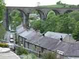
- Ingleton Viaduct, the story of a 800 foot monument to railway company irrationality
- The Original Ingleton Village website (non profit making) financing important tourism projects around the village, flower beds on the A65 village entrance, colourful hanging baskets around the village.Maintained voluntarily by local people in the village.
- Ingleton Middle School