
Wild Boar Fell
Encyclopedia
Wild Boar Fell is a mountain
(or more accurately a fell
) in Mallerstang
on the eastern edge of Cumbria
, England
. At 708 metres (2,323 ft), it is either the 4th highest fell in the Yorkshire Dales
or the 5th, whether counting nearby High Seat
(709 m) or not. (In fact neither of these are, at present, in the Yorkshire Dales National Park, although there are plans to extend its boundaries in the near future to include Mallerstang).
The nearest high point is Swarth Fell
which is a mile-long (1.5 km) ridge to the south, at . To the east, on the opposite side of the narrow dale, are High Seat
and Hugh Seat
.
which inhabited the area over 500 years ago. But it is unusual, for this area of Viking settlement, that its old Norse
name seems to have disappeared, whereas the names of many of its features, such as The Nab, Dolphinsty, etc., retain their Norse origin.
In earlier times, probably up to the mid nineteenth century, the Millstone Grit, or gritstone
, which forms the flat top of the fell, was used for making millstones. Some partly formed millstones can be seen on the eastern flank of the fell - and also on the corresponding western flank of Mallerstang Edge on the opposite side of the dale. Sand (composed of Millstone Grit) from the beach of Sand Tarn was used by local people to sharpen knives and scythes; they made "strickles" by sticking the sand to wooden blocks with tar.
A tusk, claimed to be of "the last wild boar caught on the fell", is kept in Kirkby Stephen
parish church.
During World War II Wild Boar Fell was sometimes used for training tank crews from the army base at Warcop
in the handling of tanks in difficult terrain.
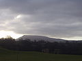
its true profile is seen, not dissimilar to Ingleborough
, with steep sides and a flat top (consisting of a cap of millstone grit
).
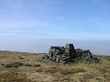
The classic route for walking up Wild Boar is via the bridle way from Hazelgill Farm, ascending west to High Dophinsty before following Scriddles ridge top to Blackbed Scar. Once there you are on Wild Boar Fell's table top plateau, a rather boggy expanse. The summit is marked by a trig point
and Sand Tarn
is about 300 m (1,000 ft) to the west, just below the summit.
The views from the top make a spectacular panorama. The Howgills, Pennines
, the Lake district
fells, the Yorkshire Three Peaks
can all be seen and, on a clear day, there is even a glimpse of the sea at Morecambe
Bay.
A common feature of many Pennine dales
and Lake District
fells are the groups of cairn
s on the high ground. There is a fine cluster of "stone men" on The Nab of Wild Boar Fell - and a smaller group on subsidiary peak, Little Fell (559 m, 1834 ft) at , 2 km to the north. There seems little agreement on when, why, or by which people such cairns were built. (One common suggestion, that they were built by shepherds as markers for paths, may explain some of the cruder "piles of stones"; but groups like those on The Nab surely need a more convincing explanation).
Mountain
Image:Himalaya_annotated.jpg|thumb|right|The Himalayan mountain range with Mount Everestrect 58 14 160 49 Chomo Lonzorect 200 28 335 52 Makalurect 378 24 566 45 Mount Everestrect 188 581 920 656 Tibetan Plateaurect 250 406 340 427 Rong River...
(or more accurately a fell
Fell
“Fell” is a word used to refer to mountains, or certain types of mountainous landscape, in Scandinavia, the Isle of Man, and parts of northern England.- Etymology :...
) in Mallerstang
Mallerstang
Mallerstang is a civil parish in the extreme east of Cumbria, and, geographically, a dale at the head of the upper Eden Valley. Originally part of Westmorland, it lies about south of the nearest town, Kirkby Stephen...
on the eastern edge of Cumbria
Cumbria
Cumbria , is a non-metropolitan county in North West England. The county and Cumbria County Council, its local authority, came into existence in 1974 after the passage of the Local Government Act 1972. Cumbria's largest settlement and county town is Carlisle. It consists of six districts, and in...
, England
England
England is a country that is part of the United Kingdom. It shares land borders with Scotland to the north and Wales to the west; the Irish Sea is to the north west, the Celtic Sea to the south west, with the North Sea to the east and the English Channel to the south separating it from continental...
. At 708 metres (2,323 ft), it is either the 4th highest fell in the Yorkshire Dales
Yorkshire Dales
The Yorkshire Dales is the name given to an upland area in Northern England.The area lies within the historic county boundaries of Yorkshire, though it spans the ceremonial counties of North Yorkshire, West Yorkshire and Cumbria...
or the 5th, whether counting nearby High Seat
High Seat (Yorkshire Dales)
High Seat is a fell in the dale of Mallerstang, Cumbria. With a summit at 709 metres, it is the fourth highest fell in the Yorkshire Dales, although outside the National Park, after Whernside, Ingleborough and Great Shunner Fell...
(709 m) or not. (In fact neither of these are, at present, in the Yorkshire Dales National Park, although there are plans to extend its boundaries in the near future to include Mallerstang).
The nearest high point is Swarth Fell
Swarth Fell
Swarth Fell is an approximately 1 mile stretch of high ground situated to the south of Wild Boar Fell, of which it is a continuation...
which is a mile-long (1.5 km) ridge to the south, at . To the east, on the opposite side of the narrow dale, are High Seat
High Seat (Yorkshire Dales)
High Seat is a fell in the dale of Mallerstang, Cumbria. With a summit at 709 metres, it is the fourth highest fell in the Yorkshire Dales, although outside the National Park, after Whernside, Ingleborough and Great Shunner Fell...
and Hugh Seat
Hugh Seat
Hugh Seat is a mountain, or more accurately a fell, in Mallerstang on the eastern edge of Cumbria, England. It lies on the present border between Cumbria and the Yorkshire Dales National Park....
.
History
The fell gets its name from the wild boarBoar
Wild boar, also wild pig, is a species of the pig genus Sus, part of the biological family Suidae. The species includes many subspecies. It is the wild ancestor of the domestic pig, an animal with which it freely hybridises...
which inhabited the area over 500 years ago. But it is unusual, for this area of Viking settlement, that its old Norse
Old Norse
Old Norse is a North Germanic language that was spoken by inhabitants of Scandinavia and inhabitants of their overseas settlements during the Viking Age, until about 1300....
name seems to have disappeared, whereas the names of many of its features, such as The Nab, Dolphinsty, etc., retain their Norse origin.
In earlier times, probably up to the mid nineteenth century, the Millstone Grit, or gritstone
Gritstone
Gritstone or Grit is a hard, coarse-grained, siliceous sandstone. This term is especially applied to such sandstones that are quarried for building material. British gritstone was used for millstones to mill flour, to grind wood into pulp for paper and for grindstones to sharpen blades. "Grit" is...
, which forms the flat top of the fell, was used for making millstones. Some partly formed millstones can be seen on the eastern flank of the fell - and also on the corresponding western flank of Mallerstang Edge on the opposite side of the dale. Sand (composed of Millstone Grit) from the beach of Sand Tarn was used by local people to sharpen knives and scythes; they made "strickles" by sticking the sand to wooden blocks with tar.
A tusk, claimed to be of "the last wild boar caught on the fell", is kept in Kirkby Stephen
Kirkby Stephen
Kirkby Stephen is a civil parish and small market town in Cumbria, in North West England which historically, is part of Westmorland. The town is located on the A685, surrounded by sparsely populated hill country, and about from the two nearest larger towns, Kendal and Penrith...
parish church.
During World War II Wild Boar Fell was sometimes used for training tank crews from the army base at Warcop
Warcop
Warcop is a village and civil parish in the Eden district of Cumbria, England. It is near the A66 road and is north of Kirkby Stephen.It had its own railway station, Warcop railway station from 1862 to 1962...
in the handling of tanks in difficult terrain.
Geography
Wild Boar Fell is a dramatic sight and a landmark for many miles around. Approached from the north it gives the misleading impression that it is a peak (see photo, above left). But from the south of the dale at AisgillAisgill
Aisgill is the southernmost of the hamlets that comprise the parish of Mallerstang in the English county of Cumbria. It is on the B6259 road, at the head of Mallerstang dale, just before the boundary between Cumbria and North Yorkshire....
its true profile is seen, not dissimilar to Ingleborough
Ingleborough
Ingleborough is the second highest mountain in the Yorkshire Dales. It is one of the Yorkshire Three Peaks, the other two being Whernside and Pen-y-ghent. Ingleborough is frequently climbed as part of the Yorkshire Three Peaks Challenge, which is a 24-mile circular challenge walk starting and...
, with steep sides and a flat top (consisting of a cap of millstone grit
Millstone Grit
Millstone Grit is the name given to any of a number of coarse-grained sandstones of Carboniferous age which occur in the Northern England. The name derives from its use in earlier times as a source of millstones for use principally in watermills...
).
The classic route for walking up Wild Boar is via the bridle way from Hazelgill Farm, ascending west to High Dophinsty before following Scriddles ridge top to Blackbed Scar. Once there you are on Wild Boar Fell's table top plateau, a rather boggy expanse. The summit is marked by a trig point
Trig point
A triangulation station, also known as a triangulation pillar, trigonometrical station, trigonometrical point, trig station, trig beacon or trig point, and sometimes informally as a trig, is a fixed surveying station, used in geodetic surveying and other surveying projects in its vicinity...
and Sand Tarn
Tarn (lake)
A tarn is a mountain lake or pool, formed in a cirque excavated by a glacier. A moraine may form a natural dam below a tarn. A corrie may be called a cirque.The word is derived from the Old Norse word tjörn meaning pond...
is about 300 m (1,000 ft) to the west, just below the summit.
The views from the top make a spectacular panorama. The Howgills, Pennines
Pennines
The Pennines are a low-rising mountain range, separating the North West of England from Yorkshire and the North East.Often described as the "backbone of England", they form a more-or-less continuous range stretching from the Peak District in Derbyshire, around the northern and eastern edges of...
, the Lake district
Lake District
The Lake District, also commonly known as The Lakes or Lakeland, is a mountainous region in North West England. A popular holiday destination, it is famous not only for its lakes and its mountains but also for its associations with the early 19th century poetry and writings of William Wordsworth...
fells, the Yorkshire Three Peaks
Yorkshire three peaks
The mountains of Whernside , Ingleborough and Pen-y-ghent are collectively known as the Three Peaks. The peaks, which form part of the...
can all be seen and, on a clear day, there is even a glimpse of the sea at Morecambe
Morecambe
Morecambe is a resort town and civil parish within the City of Lancaster in Lancashire, England. As of 2001 it has a resident population of 38,917. It faces into Morecambe Bay...
Bay.
A common feature of many Pennine dales
Dale (origin)
A dale is an open valley. The name is used when describing the physical geography of an area. It is used most frequently in the Lowlands of Scotland and in the North of England, where the term "fell" commonly refers to the mountains or hills that flank the dale.The word dale comes from the Old...
and Lake District
Lake District
The Lake District, also commonly known as The Lakes or Lakeland, is a mountainous region in North West England. A popular holiday destination, it is famous not only for its lakes and its mountains but also for its associations with the early 19th century poetry and writings of William Wordsworth...
fells are the groups of cairn
Cairn
Cairn is a term used mainly in the English-speaking world for a man-made pile of stones. It comes from the or . Cairns are found all over the world in uplands, on moorland, on mountaintops, near waterways and on sea cliffs, and also in barren desert and tundra areas...
s on the high ground. There is a fine cluster of "stone men" on The Nab of Wild Boar Fell - and a smaller group on subsidiary peak, Little Fell (559 m, 1834 ft) at , 2 km to the north. There seems little agreement on when, why, or by which people such cairns were built. (One common suggestion, that they were built by shepherds as markers for paths, may explain some of the cruder "piles of stones"; but groups like those on The Nab surely need a more convincing explanation).