

Yorkshire three peaks
Encyclopedia
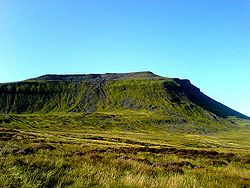
Whernside
Whernside is a mountain in the Yorkshire Dales and is one of the Yorkshire Three Peaks, the other two being Ingleborough and Pen-y-ghent. It is the highest point in the ceremonial county of North Yorkshire,Mickle Fell in southern Teesdale is the highest point within the boundaries of the historic...
(736 m (2,415 ft)), Ingleborough
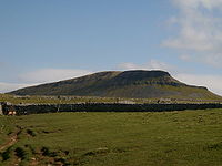
Ingleborough
Ingleborough is the second highest mountain in the Yorkshire Dales. It is one of the Yorkshire Three Peaks, the other two being Whernside and Pen-y-ghent. Ingleborough is frequently climbed as part of the Yorkshire Three Peaks Challenge, which is a 24-mile circular challenge walk starting and...
(723 m (2,372 ft)) and Pen-y-ghent
Pen-y-ghent
Pen-y-ghent is a fell in the Yorkshire Dales. It is one of the Yorkshire Three Peaks, the other two being Ingleborough and Whernside. It lies some 3 km east of Horton in Ribblesdale...
(694 m (2,277 ft)) are collectively known as the
(Yorkshire) Three Peaks. The peaks, which form part of the
Pennine range
Pennines
The Pennines are a low-rising mountain range, separating the North West of England from Yorkshire and the North East.Often described as the "backbone of England", they form a more-or-less continuous range stretching from the Peak District in Derbyshire, around the northern and eastern edges of...
, encircle the heads of the valleys of the River Ribble
River Ribble
The River Ribble is a river that runs through North Yorkshire and Lancashire, in northern England. The river's drainage basin also includes parts of Greater Manchester around Wigan.-Geography:...
and of Chapel-le-Dale
Chapel-le-Dale
Chapel-le-Dale is a hamlet in the Yorkshire Dales, England, very near Ribblehead Viaduct. The hamlet is in close proximity to Ingleborough and several potholes, the best known being Great Douk Cave. The source of the River Doe is nearby.-External links:*...
in the Yorkshire Dales National Park in the North of England
England
England is a country that is part of the United Kingdom. It shares land borders with Scotland to the north and Wales to the west; the Irish Sea is to the north west, the Celtic Sea to the south west, with the North Sea to the east and the English Channel to the south separating it from continental...
.
Geology
In common with neighbouring fellFell
“Fell” is a word used to refer to mountains, or certain types of mountainous landscape, in Scandinavia, the Isle of Man, and parts of northern England.- Etymology :...
s, the Three Peaks are carved from an almost flat-lying succession of sedimentary strata
Stratum
In geology and related fields, a stratum is a layer of sedimentary rock or soil with internally consistent characteristics that distinguish it from other layers...
of Carboniferous
Carboniferous
The Carboniferous is a geologic period and system that extends from the end of the Devonian Period, about 359.2 ± 2.5 Mya , to the beginning of the Permian Period, about 299.0 ± 0.8 Mya . The name is derived from the Latin word for coal, carbo. Carboniferous means "coal-bearing"...
age. The lower slopes of each of the fells are formed from alternating bands of sandstone
Sandstone
Sandstone is a sedimentary rock composed mainly of sand-sized minerals or rock grains.Most sandstone is composed of quartz and/or feldspar because these are the most common minerals in the Earth's crust. Like sand, sandstone may be any colour, but the most common colours are tan, brown, yellow,...
and limestone
Limestone
Limestone is a sedimentary rock composed largely of the minerals calcite and aragonite, which are different crystal forms of calcium carbonate . Many limestones are composed from skeletal fragments of marine organisms such as coral or foraminifera....
assigned by geologists to the Visean
Viséan
The Visean, Viséan or Visian is an age in the ICS geologic timescale or a stage in the stratigraphic column. It is the second stage of the Mississippian, the lower subsystem of the Carboniferous. The Visean lasted from 345.3 ± 2.1 to 328.3 ± 1.6 Ma...
age Wensleydale Group. The upper slopes of each of the fells is formed from alternating bands of coarse sandstone (or 'gritstone
Gritstone
Gritstone or Grit is a hard, coarse-grained, siliceous sandstone. This term is especially applied to such sandstones that are quarried for building material. British gritstone was used for millstones to mill flour, to grind wood into pulp for paper and for grindstones to sharpen blades. "Grit" is...
') and mudstone
Mudstone
Mudstone is a fine grained sedimentary rock whose original constituents were clays or muds. Grain size is up to 0.0625 mm with individual grains too small to be distinguished without a microscope. With increased pressure over time the platey clay minerals may become aligned, with the...
all of which are assigned to the Namurian
Namurian
The Namurian is a stage in the regional stratigraphy of northwest Europe with an age between roughly 326 and 313 Ma . It is a subdivision of the Carboniferous system or period and the regional Silesian series. The Namurian is named for the Belgian city and province of Namur where strata of this age...
age Stainmore Group but which were formerly referred to as the Yoredale Series
Yoredale Series
The Yoredale Series, in geology, is a local phase of the lower Carboniferous rocks of the north of England. The name was introduced by J. Phillips on account of the typical development of the phase in Yoredale , Yorkshire....
. These alternations are considered to be a classic British example of cyclothems
Cyclothems
In geology, cyclothems are alternating stratigraphic sequences of marine and non-marine sediments, sometimes interbedded with coal seams. Historically, the term was defined by the European coal geologists that worked in coal basins formed during the Carboniferous and earliest Permian periods...
. Differential weathering
Weathering
Weathering is the breaking down of rocks, soils and minerals as well as artificial materials through contact with the Earth's atmosphere, biota and waters...
and erosion
Erosion
Erosion is when materials are removed from the surface and changed into something else. It only works by hydraulic actions and transport of solids in the natural environment, and leads to the deposition of these materials elsewhere...
of the various bands has given Ingleborough and Pen-y-ghent a distinctive, stepped appearance.
Considerable areas of the flanks of each of the fells are covered by peat
Peat
Peat is an accumulation of partially decayed vegetation matter or histosol. Peat forms in wetland bogs, moors, muskegs, pocosins, mires, and peat swamp forests. Peat is harvested as an important source of fuel in certain parts of the world...
whilst other areas are blanketed by glacial till notably across the southern and eastern slopes of Pen-y-ghent. Fringing Ingleborough on each side however are impressive areas of limestone pavement
Limestone pavement
A limestone pavement is a natural karst landform consisting of a flat, incised surface of exposed limestone that resembles an artificial pavement. The term is mainly used in the UK where many of these landforms have developed distinctive surface patterning resembling block of paving...
.
Extensive networks of cave
Cave
A cave or cavern is a natural underground space large enough for a human to enter. The term applies to natural cavities some part of which is in total darkness. The word cave also includes smaller spaces like rock shelters, sea caves, and grottos.Speleology is the science of exploration and study...
s have developed within the limestone strata such as the White Scar Caves
White Scar Caves
White Scar Caves is a network of caves under Ingleborough in the Chapel-le-Dale valley of the Yorkshire Dales National Park in the North of England.Discovered in August 1923 by two amateur geologists, Christopher Long and J.H...
, and potholes which attract cavers
Caving
Caving—also occasionally known as spelunking in the United States and potholing in the United Kingdom—is the recreational pastime of exploring wild cave systems...
from all over the country. It is home to England's highest waterfall
Waterfall
A waterfall is a place where flowing water rapidly drops in elevation as it flows over a steep region or a cliff.-Formation:Waterfalls are commonly formed when a river is young. At these times the channel is often narrow and deep. When the river courses over resistant bedrock, erosion happens...
at Gaping Gill
Gaping Gill
Gaping Gill is a natural cave in North Yorkshire, England. It is one of the unmistakable landmarks on the southern slopes of Ingleborough – a deep pothole with the stream Fell Beck flowing into it...
, where the Fell Beck drops 110 m (361 ft) vertically down a pothole, into Britain's second largest cavern. The beck re-emerges further down the mountain adjacent to Ingleborough Cave
Ingleborough Cave
Ingleborough Cave is a show cave close to the village of Clapham, North Yorkshire, England adjacent to where the water from Gaping Gill resurges....
, where visitors can take a guided tour of a floodlit part of the cave system. Whernside, being more rounded, is visually less imposing than its neighbours, but its summit is the highest point in Yorkshire
Yorkshire
Yorkshire is a historic county of northern England and the largest in the United Kingdom. Because of its great size in comparison to other English counties, functions have been increasingly undertaken over time by its subdivisions, which have also been subject to periodic reform...
.
History
The area is rich in historical interest. The summit of Ingleborough has the remains of a huge Iron AgeIron Age
The Iron Age is the archaeological period generally occurring after the Bronze Age, marked by the prevalent use of iron. The early period of the age is characterized by the widespread use of iron or steel. The adoption of such material coincided with other changes in society, including differing...
hill fort
Hill fort
A hill fort is a type of earthworks used as a fortified refuge or defended settlement, located to exploit a rise in elevation for defensive advantage. They are typically European and of the Bronze and Iron Ages. Some were used in the post-Roman period...
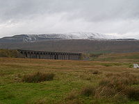
, while the Settle-Carlisle Railway
Settle-Carlisle Railway
The Settle–Carlisle Line is a long main railway line in northern England. It is also known as the Settle and Carlisle. It is a part of the National Rail network and was constructed in the 1870s...
runs between the mountains, crossing Ribblehead Viaduct
Ribblehead Viaduct
Ribblehead Viaduct is a railway viaduct across the valley of the River Ribble at Ribblehead, in North Yorkshire, northern England. The viaduct is a Grade II* listed building and a Scheduled Ancient Monument.-Description:...
at the foot of Whernside.
Leisure
- The Pennine WayPennine WayThe Pennine Way is a National Trail in England. The trail runs from Edale, in the northern Derbyshire Peak District, north through the Yorkshire Dales and the Northumberland National Park and ends at Kirk Yetholm, just inside the Scottish border. The path runs along the Pennine hills, sometimes...
visits Horton and crosses the summit of Pen-y-ghent. - The Ribble WayRibble WayThe Ribble way is a long distance walk between the Lancashire coast and the Yorkshire Dales National Park largely following the course of the River Ribble....
follows the River Ribble from its source near the foot of Whernside to its mouth near Preston.
The Three Peaks walk
The Three Peaks walk of Pen-y-ghent, Whernside and Ingleborugh is probably the original three peak walk within the UK. The first recorded ascent of the three hills was in July 1887 by J.R. Wynne-Edwards and D.R. Smith in a time of 10 hours. The walk covers a distance of 37.5 km (23.3 mi) to 42 km (26.1 mi) (depending on route) circuit of all three peaks with nearly 1600 m (5,249 ft) of ascent and descent. A challenge that may walkers aim for when undertaking the walk is to complete the walk in under 12 hours, though as Alfred WainwrightAlfred Wainwright
Alfred Wainwright MBE was a British fellwalker, guidebook author and illustrator. His seven-volume Pictorial Guide to the Lakeland Fells, published between 1955 and 1966 and consisting entirely of reproductions of his manuscript, has become the standard reference work to 214 of the fells of the...
says in his book Wainwright in the Yorkshire Dales “Some people have chosen to regard the walk as a race, and this is to be greatly regretted, walking is a pleasure to be enjoyed in comfort”. The route most walkers take varies from the fell race in that most traverse the 'nose' of Pen-y-ghent from Brackenbottom Moor and do not ascend from the Pennine Way. Additionally, Whernside is generally traversed along the right-of-way to the east following the railway line, all of which can add extra distance to the route.
For most people the route starts in the village of Horton-in-Ribblesdale, though many start from various points in the circular route, such as Chapel-le-Dale
Chapel-le-Dale
Chapel-le-Dale is a hamlet in the Yorkshire Dales, England, very near Ribblehead Viaduct. The hamlet is in close proximity to Ingleborough and several potholes, the best known being Great Douk Cave. The source of the River Doe is nearby.-External links:*...
. Historically Chapel-le-Dale was the starting point though this probably changed when the, Pen-y-ghent Cafe started running their clocking in and out service for walkers in 1968. The cafe did run a free safety-service for walkers, however thas been temporarily suspended, but walkers can still register the beginning and end of their walk at Pen-y-ghent Cafe. Those that complete the walk within 12 hours are invited to pay to join the Pen-y-ghent Cafe's privately owned 'Three Peaks of Yorkshire Club'.
The Yorkshire Dales National Park runs a voluntary Friends of the Three Peaks
Friends of the Three Peaks
The Friends of the Three Peaks are a group of individuals and organisations who want to protect and enhance the special qualities of the distinctive and inspirational landscapes of the Three Peaks area in the Yorkshire Dales National Park....
project. The proceeds of this go towards the upkeep of the paths on the route. Certificates, medals and membership forms are awarded by local participating businesses.
The walking challenge
Understandably the Three Peaks Walk is seen by many as a challenge and it has become very popular for charity sponsored walks and Saturdays in early summer can see several hundred walkers make their way round the route.The races
In addition to it being seen as a walking challenge it has also become a race for fell runners and cyclo-cross cyclists.- The Three Peaks RaceThree Peaks RaceThe Australian Three Peaks Race is a short-handed offshore sailing and endurance mountain running event held in Tasmania, the southern-most state of Australia, over the Easter long weekend...
, has been held annually since 1954 and traditionally started at the Hill Inn until 1975, when the start moved to Horton. In 2008 this race was also the World Long Distance Mountain Running ChallengeWorld Long Distance Mountain Running ChallengeThe World Long Distance Mountain Running Challenge is an annual international mountain running competition organised by the World Mountain Running Association ....
. - The Three Peaks Cyclo-Cross race follows a longer, 61 km (38 mi), route across the peaks.
Media
The Three Peaks were featured on the TV programme Seven Natural WondersSeven Natural Wonders
Seven Natural Wonders was a television series that was broadcast on BBC Two from 3 May to 20 June 2005. The programme took an area of England each week and, from votes by the people living in that area, showed the 'seven natural wonders' of that area in a programme.The programmes were:The series...
as one of the wonders of Yorkshire.
 |
 |