
Whernside
Encyclopedia
Whernside is a mountain
in the Yorkshire Dales
and is one of the Yorkshire Three Peaks
, the other two being Ingleborough
and Pen-y-ghent
. It is the highest point in the ceremonial county
of North Yorkshire
,Mickle Fell
in southern Teesdale
is the highest point within the boundaries of the historic county
of Yorkshire
.
with the summit lying on the county border with Cumbria
.
In shape Whernside forms a long ridge, running roughly north–south.
that heads north via Smithy Hill, Grain Ings before turning west to Knoutberry Haw and then south to Whernside itself. From the summit the ROW heads initially south then steeply southwest down a stepped path to the small village of Bruntscar. If climbed as part of the Yorkshire Three Peaks
Challenge (which is normally done anti-clockwise) Whernside will be climbed following the route from up Ribblehead to descend to Bruntscar.
There are however other routes up/down the mountain which are not Rights of Way.
A path heads directly west from the triangulation pillar to reach the road that is Deepdale Lane near White Shaw Moss.
An alternative route heads directly north across Knoutberry Haw to pass Whernside Tarns and reaches the Craven Way at Boot of the Wold.
Following the southern descent for 0.76 miles (1.2 km), instead of turning steeply southeast towards Bruntscar a path continues south running adjacent the wall passing Combe Scar and West Fell to reach the limestone pavements at Ewe's Top.
Finally, 275 yards (251.5 m) south of the triangulation pillar an old route (partly fenced off) descends (initially very steeply) for 1.3 miles (2 km) to reach a road 275 yards (251.5 m) southwest of Winterscales Farm, this is the old route of the Three Peaks Challenge. Walkers should select this route with care as it is no longer maintained, boggy, badly eroded and requires extreme care over the final steep ascent/descent. The current route of the Three Peaks fell race
runs approximately 440 yards (402.3 m) north of this old ascent along open moor.
All paths are on Access Land and make an interesting change from the Right of Way ascents/descents.
and Morecambe Bay
, including (with the aid of binoculars) Blackpool Tower
, some 40 miles (64.4 km) away.
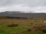
Whernside lies about 2 miles (3 km) northwest of Ribblehead Viaduct
on the Settle–Carlisle Railway
.
Whernside is sometimes confused with the lower peaks of Great Whernside
17 miles (27 km) away) and Little Whernside, which are both to the east of Whernside. The word "Whern" is believed to refer to querns (millstone
s) whilst "side" is derived from the Norse "Saettr", meaning an area of summer pasture.
Mountain
Image:Himalaya_annotated.jpg|thumb|right|The Himalayan mountain range with Mount Everestrect 58 14 160 49 Chomo Lonzorect 200 28 335 52 Makalurect 378 24 566 45 Mount Everestrect 188 581 920 656 Tibetan Plateaurect 250 406 340 427 Rong River...
in the Yorkshire Dales
Yorkshire Dales
The Yorkshire Dales is the name given to an upland area in Northern England.The area lies within the historic county boundaries of Yorkshire, though it spans the ceremonial counties of North Yorkshire, West Yorkshire and Cumbria...
and is one of the Yorkshire Three Peaks
Yorkshire three peaks
The mountains of Whernside , Ingleborough and Pen-y-ghent are collectively known as the Three Peaks. The peaks, which form part of the...
, the other two being Ingleborough
Ingleborough
Ingleborough is the second highest mountain in the Yorkshire Dales. It is one of the Yorkshire Three Peaks, the other two being Whernside and Pen-y-ghent. Ingleborough is frequently climbed as part of the Yorkshire Three Peaks Challenge, which is a 24-mile circular challenge walk starting and...
and Pen-y-ghent
Pen-y-ghent
Pen-y-ghent is a fell in the Yorkshire Dales. It is one of the Yorkshire Three Peaks, the other two being Ingleborough and Whernside. It lies some 3 km east of Horton in Ribblesdale...
. It is the highest point in the ceremonial county
Ceremonial counties of England
The ceremonial counties are areas of England to which are appointed a Lord Lieutenant, and are defined by the government as counties and areas for the purposes of the Lieutenancies Act 1997 with reference to the metropolitan and non-metropolitan counties of England and Lieutenancies Act 1997...
of North Yorkshire
North Yorkshire
North Yorkshire is a non-metropolitan or shire county located in the Yorkshire and the Humber region of England, and a ceremonial county primarily in that region but partly in North East England. Created in 1974 by the Local Government Act 1972 it covers an area of , making it the largest...
,Mickle Fell
Mickle Fell
Mickle Fell is a mountain in the Pennines, the range of hills and moors running down the middle of Northern England. It is 788 m high and lies slightly off the main watershed of the Pennines, about ten miles south of Cross Fell....
in southern Teesdale
Teesdale
Teesdale is a dale, or valley, of the east side of the Pennines in England. Large parts of Teesdale fall within the North Pennines Area of Outstanding Natural Beauty - the second largest AONB in England and Wales. The River Tees rises below Cross Fell, the highest hill in the Pennines, and its...
is the highest point within the boundaries of the historic county
Historic counties of England
The historic counties of England are subdivisions of England established for administration by the Normans and in most cases based on earlier Anglo-Saxon kingdoms and shires...
of Yorkshire
Yorkshire
Yorkshire is a historic county of northern England and the largest in the United Kingdom. Because of its great size in comparison to other English counties, functions have been increasingly undertaken over time by its subdivisions, which have also been subject to periodic reform...
.
with the summit lying on the county border with Cumbria
Cumbria
Cumbria , is a non-metropolitan county in North West England. The county and Cumbria County Council, its local authority, came into existence in 1974 after the passage of the Local Government Act 1972. Cumbria's largest settlement and county town is Carlisle. It consists of six districts, and in...
.
In shape Whernside forms a long ridge, running roughly north–south.
Routes
There is a Right of Way footpath running from the east at RibbleheadRibblehead
Ribblehead is the area of moorland at the head of the River Ribble in the area known as Ribblesdale, in the Yorkshire Dales National Park, England....
that heads north via Smithy Hill, Grain Ings before turning west to Knoutberry Haw and then south to Whernside itself. From the summit the ROW heads initially south then steeply southwest down a stepped path to the small village of Bruntscar. If climbed as part of the Yorkshire Three Peaks
Yorkshire three peaks
The mountains of Whernside , Ingleborough and Pen-y-ghent are collectively known as the Three Peaks. The peaks, which form part of the...
Challenge (which is normally done anti-clockwise) Whernside will be climbed following the route from up Ribblehead to descend to Bruntscar.
There are however other routes up/down the mountain which are not Rights of Way.
A path heads directly west from the triangulation pillar to reach the road that is Deepdale Lane near White Shaw Moss.
An alternative route heads directly north across Knoutberry Haw to pass Whernside Tarns and reaches the Craven Way at Boot of the Wold.
Following the southern descent for 0.76 miles (1.2 km), instead of turning steeply southeast towards Bruntscar a path continues south running adjacent the wall passing Combe Scar and West Fell to reach the limestone pavements at Ewe's Top.
Finally, 275 yards (251.5 m) south of the triangulation pillar an old route (partly fenced off) descends (initially very steeply) for 1.3 miles (2 km) to reach a road 275 yards (251.5 m) southwest of Winterscales Farm, this is the old route of the Three Peaks Challenge. Walkers should select this route with care as it is no longer maintained, boggy, badly eroded and requires extreme care over the final steep ascent/descent. The current route of the Three Peaks fell race
Three Peaks Race
The Australian Three Peaks Race is a short-handed offshore sailing and endurance mountain running event held in Tasmania, the southern-most state of Australia, over the Easter long weekend...
runs approximately 440 yards (402.3 m) north of this old ascent along open moor.
All paths are on Access Land and make an interesting change from the Right of Way ascents/descents.
General
On a clear day the views from the summit to the west can be spectacular, with views of the Lake DistrictLake District
The Lake District, also commonly known as The Lakes or Lakeland, is a mountainous region in North West England. A popular holiday destination, it is famous not only for its lakes and its mountains but also for its associations with the early 19th century poetry and writings of William Wordsworth...
and Morecambe Bay
Morecambe Bay
Morecambe Bay is a large bay in northwest England, nearly due east of the Isle of Man and just to the south of the Lake District National Park. It is the largest expanse of intertidal mudflats and sand in the United Kingdom, covering a total area of 310 km².-Natural features:The rivers Leven,...
, including (with the aid of binoculars) Blackpool Tower
Blackpool Tower
Blackpool Tower Eye is a tourist attraction in Blackpool, Lancashire in England which was opened to the public on 14 May 1894. . Inspired by the Eiffel Tower in Paris, it rises to 518 feet & 9 inches . The tower is a member of the World Federation of Great Towers...
, some 40 miles (64.4 km) away.
Whernside lies about 2 miles (3 km) northwest of Ribblehead Viaduct
Ribblehead Viaduct
Ribblehead Viaduct is a railway viaduct across the valley of the River Ribble at Ribblehead, in North Yorkshire, northern England. The viaduct is a Grade II* listed building and a Scheduled Ancient Monument.-Description:...
on the Settle–Carlisle Railway
Settle-Carlisle Railway
The Settle–Carlisle Line is a long main railway line in northern England. It is also known as the Settle and Carlisle. It is a part of the National Rail network and was constructed in the 1870s...
.
Whernside is sometimes confused with the lower peaks of Great Whernside
Great Whernside
Great Whernside is a mountain in the Yorkshire Dales, England, not to be confused with the better known Whernside, some to the west. Its summit is the highest point of the eastern flank of Wharfedale above Kettlewell...
17 miles (27 km) away) and Little Whernside, which are both to the east of Whernside. The word "Whern" is believed to refer to querns (millstone
Millstone
Millstones or mill stones are used in windmills and watermills, including tide mills, for grinding wheat or other grains.The type of stone most suitable for making millstones is a siliceous rock called burrstone , an open-textured, porous but tough, fine-grained sandstone, or a silicified,...
s) whilst "side" is derived from the Norse "Saettr", meaning an area of summer pasture.
External links
- Computer generated summit panoramas Whernside index
- Photos of Whernside and surrounding area on geograph.org.uk