
Cross Fell
Encyclopedia
Cross Fell is the highest point in the Pennine Hills
of northern England
and the highest point in England outside of the Lake District
.
The summit, at 893 metres (2,930 ft), is a stony plateau
, part of a 12.5 km (7.8 mi) long ridge running North West to South East, which also incorporates Little Dun Fell at 842 metres (2,762 ft) and Great Dun Fell
at 849 metres (2,785 ft). The three adjoining fell
s form an escarpment
that rises steeply above the Eden Valley
on its south western side and drops off more gently on its north eastern side towards the South Tyne
and Tees
Valleys.
Cross Fell summit is crowned by a cross-shaped dry-stone shelter. On a clear day there are excellent views from the summit across the Eden Valley to the mountains of the Lake District. On the northern side of Cross Fell there are also fine views across the Solway Firth
to the Southern Uplands
of Scotland
.
The fell is prone to dense hill fog and fierce winds. A shrieking noise induced by the Helm Wind
is a characteristic of the locality. It can be an inhospitable place for much of the year. In ancient times it was known as "Fiends Fell" and believed to be the haunt of evil spirits. It has been speculated that this last feature may be why the fell became known as Cross Fell ("cross" meaning "angry").
A conspicuous local feature is the golf ball shaped radar installation on the summit of Great Dun Fell
. This was built in the 1980s and supports civil air traffic control over the North Atlantic. The original site was built on the summit in 1949.
. Where this bed surfaces, there are steep rock faces. There are also strata
of shale
and gritstone
that surface on the fell. On the south and west facing slopes of Cross Fell the rock faces have been broken up by frost action to give a scree
slope made up of large boulders. The local terrain shows obvious evidence of recent glaciation and is covered by thin soil and acidic peat
.
Cross Fell, Great Dun Fell and Little Dun Fell form a block of high terrain which is all over 800 metres (2,625 ft) in altitude. This is the largest block of high ground in England and tends to retain snow-cover longer than neighbouring areas. Snow can be found in gullies on the north side of Cross Fell as late as May in most years. In some years, lying snow has been known to persist until July and fresh snowfall in June (mid-summer in the Northern Hemisphere) is common.
Precipitation
on Cross Fell averages around 280 centimetres (110 in) per year. Local flora includes a number of rare alpine plants such as the Starry Saxifrage and a mountain Forget-me-not
. Cross Fell is covered by what is known as "siliceous alpine and boreal grassland". It is the southernmost outlier of this vegetation type, which is common to highlands in Scotland and Scandinavia. It is a designated Special Area of Conservation
(SAC). Local farmers are required to keep free-roaming sheep off the tops of the fells in order to avoid damaging the natural flora.
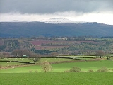
Cross Fell is a conspicuous feature in the landscape. It dominates the skyline on almost the entire 20 miles (32 km) length of the A66 trunk road
between Penrith
and Stainmore
. It can also be seen from Helvellyn
summit in the Lake District and from high ground throughout Dumfriesshire
and Northumberland
.
Pennines
The Pennines are a low-rising mountain range, separating the North West of England from Yorkshire and the North East.Often described as the "backbone of England", they form a more-or-less continuous range stretching from the Peak District in Derbyshire, around the northern and eastern edges of...
of northern England
Northern England
Northern England, also known as the North of England, the North or the North Country, is a cultural region of England. It is not an official government region, but rather an informal amalgamation of counties. The southern extent of the region is roughly the River Trent, while the North is bordered...
and the highest point in England outside of the Lake District
Lake District
The Lake District, also commonly known as The Lakes or Lakeland, is a mountainous region in North West England. A popular holiday destination, it is famous not only for its lakes and its mountains but also for its associations with the early 19th century poetry and writings of William Wordsworth...
.
The summit, at 893 metres (2,930 ft), is a stony plateau
Plateau
In geology and earth science, a plateau , also called a high plain or tableland, is an area of highland, usually consisting of relatively flat terrain. A highly eroded plateau is called a dissected plateau...
, part of a 12.5 km (7.8 mi) long ridge running North West to South East, which also incorporates Little Dun Fell at 842 metres (2,762 ft) and Great Dun Fell
Great Dun Fell
Great Dun Fell is the second-highest hill in the Pennine range, United Kingdom, lying two miles south along the watershed from Cross Fell, its higher neighbour...
at 849 metres (2,785 ft). The three adjoining fell
Fell
“Fell” is a word used to refer to mountains, or certain types of mountainous landscape, in Scandinavia, the Isle of Man, and parts of northern England.- Etymology :...
s form an escarpment
Escarpment
An escarpment is a steep slope or long cliff that occurs from erosion or faulting and separates two relatively level areas of differing elevations.-Description and variants:...
that rises steeply above the Eden Valley
River Eden, Cumbria
The River Eden is a river that flows through Cumbria, England on its way to the Solway Firth.-Course of river:The Eden rises in Black Fell Moss, Mallerstang, on the high ground between High Seat, Yorkshire Dales and Hugh Seat. Here it forms the boundary between the counties of Cumbria and North...
on its south western side and drops off more gently on its north eastern side towards the South Tyne
River Tyne
The River Tyne is a river in North East England in Great Britain. It is formed by the confluence of two rivers: the North Tyne and the South Tyne. These two rivers converge at Warden Rock near Hexham in Northumberland at a place dubbed 'The Meeting of the Waters'.The North Tyne rises on the...
and Tees
River Tees
The River Tees is in Northern England. It rises on the eastern slope of Cross Fell in the North Pennines, and flows eastwards for 85 miles to reach the North Sea between Hartlepool and Redcar.-Geography:...
Valleys.
Cross Fell summit is crowned by a cross-shaped dry-stone shelter. On a clear day there are excellent views from the summit across the Eden Valley to the mountains of the Lake District. On the northern side of Cross Fell there are also fine views across the Solway Firth
Solway Firth
The Solway Firth is a firth that forms part of the border between England and Scotland, between Cumbria and Dumfries and Galloway. It stretches from St Bees Head, just south of Whitehaven in Cumbria, to the Mull of Galloway, on the western end of Dumfries and Galloway. The Isle of Man is also very...
to the Southern Uplands
Southern Uplands
The Southern Uplands are the southernmost and least populous of mainland Scotland's three major geographic areas . The term is used both to describe the geographical region and to collectively denote the various ranges of hills within this region...
of Scotland
Scotland
Scotland is a country that is part of the United Kingdom. Occupying the northern third of the island of Great Britain, it shares a border with England to the south and is bounded by the North Sea to the east, the Atlantic Ocean to the north and west, and the North Channel and Irish Sea to the...
.
The fell is prone to dense hill fog and fierce winds. A shrieking noise induced by the Helm Wind
Helm Wind
The Helm Wind is a named wind in Cumbria, England, a strong north-easterly wind which blows down the south-west slope of the Cross Fell escarpment. It is the only named wind in the British Isles, although many other mountain regions in Britain exhibit the same phenomenon when the weather conditions...
is a characteristic of the locality. It can be an inhospitable place for much of the year. In ancient times it was known as "Fiends Fell" and believed to be the haunt of evil spirits. It has been speculated that this last feature may be why the fell became known as Cross Fell ("cross" meaning "angry").
A conspicuous local feature is the golf ball shaped radar installation on the summit of Great Dun Fell
Great Dun Fell
Great Dun Fell is the second-highest hill in the Pennine range, United Kingdom, lying two miles south along the watershed from Cross Fell, its higher neighbour...
. This was built in the 1980s and supports civil air traffic control over the North Atlantic. The original site was built on the summit in 1949.
Local geography
Cross Fell and the adjoining fells are mainly a bed of hard, carboniferous limestoneCarboniferous limestone
Carboniferous Limestone is a term used to describe a variety of different types of limestone occurring widely across Great Britain and Ireland which were deposited during the Dinantian epoch of the Carboniferous period. They were formed between 363 and 325 million years ago...
. Where this bed surfaces, there are steep rock faces. There are also strata
Stratum
In geology and related fields, a stratum is a layer of sedimentary rock or soil with internally consistent characteristics that distinguish it from other layers...
of shale
Shale
Shale is a fine-grained, clastic sedimentary rock composed of mud that is a mix of flakes of clay minerals and tiny fragments of other minerals, especially quartz and calcite. The ratio of clay to other minerals is variable. Shale is characterized by breaks along thin laminae or parallel layering...
and gritstone
Gritstone
Gritstone or Grit is a hard, coarse-grained, siliceous sandstone. This term is especially applied to such sandstones that are quarried for building material. British gritstone was used for millstones to mill flour, to grind wood into pulp for paper and for grindstones to sharpen blades. "Grit" is...
that surface on the fell. On the south and west facing slopes of Cross Fell the rock faces have been broken up by frost action to give a scree
Scree
Scree, also called talus, is a term given to an accumulation of broken rock fragments at the base of crags, mountain cliffs, or valley shoulders. Landforms associated with these materials are sometimes called scree slopes or talus piles...
slope made up of large boulders. The local terrain shows obvious evidence of recent glaciation and is covered by thin soil and acidic peat
Peat
Peat is an accumulation of partially decayed vegetation matter or histosol. Peat forms in wetland bogs, moors, muskegs, pocosins, mires, and peat swamp forests. Peat is harvested as an important source of fuel in certain parts of the world...
.
Cross Fell, Great Dun Fell and Little Dun Fell form a block of high terrain which is all over 800 metres (2,625 ft) in altitude. This is the largest block of high ground in England and tends to retain snow-cover longer than neighbouring areas. Snow can be found in gullies on the north side of Cross Fell as late as May in most years. In some years, lying snow has been known to persist until July and fresh snowfall in June (mid-summer in the Northern Hemisphere) is common.
Precipitation
Precipitation (meteorology)
In meteorology, precipitation In meteorology, precipitation In meteorology, precipitation (also known as one of the classes of hydrometeors, which are atmospheric water phenomena is any product of the condensation of atmospheric water vapor that falls under gravity. The main forms of precipitation...
on Cross Fell averages around 280 centimetres (110 in) per year. Local flora includes a number of rare alpine plants such as the Starry Saxifrage and a mountain Forget-me-not
Forget-me-not
Myosotis is a genus of flowering plants in the family Boraginaceae that are commonly called Forget-me-nots. Its common name was calqued from the French, "ne m'oubliez pas" and first used in English in c. 1532. Similar names and variations are found in many languages.-Description:There are...
. Cross Fell is covered by what is known as "siliceous alpine and boreal grassland". It is the southernmost outlier of this vegetation type, which is common to highlands in Scotland and Scandinavia. It is a designated Special Area of Conservation
Special Area of Conservation
A Special Area of Conservation is defined in the European Union's Habitats Directive , also known as the Directive on the Conservation of Natural Habitats and of Wild Fauna and Flora...
(SAC). Local farmers are required to keep free-roaming sheep off the tops of the fells in order to avoid damaging the natural flora.
Cross Fell is a conspicuous feature in the landscape. It dominates the skyline on almost the entire 20 miles (32 km) length of the A66 trunk road
A66 road
The A66 is a major road in northern England which in part follows the course of the Roman road from Scotch Corner to Penrith. It runs from east of Middlesbrough in the ceremonial county of North Yorkshire to Workington in Cumbria...
between Penrith
Penrith, Cumbria
Penrith was an urban district between 1894 and 1974, when it was merged into Eden District.The authority's area was coterminous with the civil parish of Penrith although when the council was abolished Penrith became an unparished area....
and Stainmore
Stainmore
Stainmore is a civil parish in the Eden District of Cumbria, England, including the villages of North Stainmore and South Stainmore. It has a population of 253.- Geography :...
. It can also be seen from Helvellyn
Helvellyn
Helvellyn is a mountain in the English Lake District, the apex of the Eastern Fells. At above sea level, it is the third highest peak in both the Lake District and England...
summit in the Lake District and from high ground throughout Dumfriesshire
Dumfriesshire
Dumfriesshire or the County of Dumfries is a registration county of Scotland. The lieutenancy area of Dumfries has similar boundaries.Until 1975 it was a county. Its county town was Dumfries...
and Northumberland
Northumberland
Northumberland is the northernmost ceremonial county and a unitary district in North East England. For Eurostat purposes Northumberland is a NUTS 3 region and is one of three boroughs or unitary districts that comprise the "Northumberland and Tyne and Wear" NUTS 2 region...
.