
Grasmoor
Encyclopedia
Grasmoor is a mountain
in the north-western part of the Lake District
, northern England
. It is the highest peak in a group of hills between the villages of Lorton
, Braithwaite
and Buttermere
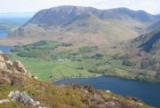
, and overlooks Crummock Water
.
Grasmoor is distinguished by its steep western flank, dropping dramatically to Crummock Water. This face is however not suitable for rock climbers as there is little clean rock, although Alfred Wainwright
describes a challenging route up the face in his Pictorial Guides to the Lakeland Fells. To the east the fell
is linked to others by Crag Hill
and Coledale Hause. Grasmoor is also home to the most extensive scree slopes in the North Western Fells.
element grise, meaning wild boar. This element appears in other Lake District place names, including Grisedale Pike
and Grizedale Forest
.
occupy the area between the rivers Derwent and Cocker, a broadly oval swathe of hilly country, elongated on a north-south axis. Two roads cross from east to west, dividing the fells into three convenient groups. The central sector, rising between Whinlatter Pass
and Newlands Pass
, includes Grasmoor.
The highest ground in the North Western Fells is an east-west ridge in this central sector, beginning with Grasmoor above Crummock Water and then gradually descending eastwards over Crag Hill, Sail
, Scar Crags
and Causey Pike
. Grasmoor has the greatest elevation, although Crag Hill stands at the hub of the range.
From the valley floor near Little Town at the eastern end, the ridge requires four miles (6 km) of gradual ascent to attain the summit of Grasmoor. Starting at the shores of Crummock Water in the west, the same is achieved by a single slope of scree in less than a quarter of the distance. Grasmoor is Lakeland's terminal height par excellence.
The summit area is a gently domed promenade of moss and short grass, running along the ridgeline with a narrow constriction in the middle. This is created primarily by the scooped-out bowl of Dove Crags on the northern face. To the east of this plateau are broad smooth slopes descending to a wide unnamed col
at 2368 ft (721.8 m). This connects onward to Crag Hill. At the western end the summit area narrows, culminating at the subsidiary top of Grasmoor End (2,445 ft) which crowns the western face. Great fans of scree descend to the lakeside road below. Grasmoor has one minor ridge which descends south westward over Lad Hows (1,397 ft) before a steeper fall to the valley floor.
To the south of Grasmoor is the valley of Rannerdale, which flows to Crummock Water between Lad Hows and the neighbouring Wandope
. This drainage is supplemented by Cinderdale Beck, separating Lad Hows from the main body of the fell. The northern flank of the ridge stands above Liza Beck. This stream also makes due west for Crummock Water, but is diverted northward by the low top of Lanthwaite Hill to join the Cocker after its exit from the lake. An area of lowland to the north west is thus annexed to Grasmoor from the natural territory of Whiteside
.
Kirkstile Formation. These are laminated mudstone
and siltstone
, typical of the Skiddaw
range. There is no history of mining beneath the slopes of Grasmoor.
. There are many smaller cairns and the top is characterised by sheep-mown grass. The view is extensive although robbed of some foreground by the extent of the summit. All of the major Lakeland ranges are in sight with the exception of the Far Eastern Fells
, with High Stile
above Crummock Water
perhaps the highpoint. This is best seen from the western end of the plateau.
in the east. Coledale Hause connects to Hopegill Head
and the fells to the north, providing further indirect possibilities.
The summit was conquered by a Rolls Royce in 1982.
Mountain
Image:Himalaya_annotated.jpg|thumb|right|The Himalayan mountain range with Mount Everestrect 58 14 160 49 Chomo Lonzorect 200 28 335 52 Makalurect 378 24 566 45 Mount Everestrect 188 581 920 656 Tibetan Plateaurect 250 406 340 427 Rong River...
in the north-western part of the Lake District
Lake District
The Lake District, also commonly known as The Lakes or Lakeland, is a mountainous region in North West England. A popular holiday destination, it is famous not only for its lakes and its mountains but also for its associations with the early 19th century poetry and writings of William Wordsworth...
, northern England
England
England is a country that is part of the United Kingdom. It shares land borders with Scotland to the north and Wales to the west; the Irish Sea is to the north west, the Celtic Sea to the south west, with the North Sea to the east and the English Channel to the south separating it from continental...
. It is the highest peak in a group of hills between the villages of Lorton
Lorton, Cumbria
Lorton is a civil parish in the district of Allerdale, in the county of Cumbria, England, containing two small villages - Low Lorton and High Lorton, both approximately four miles south of Cockermouth. At the time of the 2001 census, the parish had a total population of 250 people...
, Braithwaite
Braithwaite
Braithwaite is a village in the northern Lake District, in Cumbria, England. Historically within Cumberland, it lies just to the west of Keswick and to the east of the Grisedale Pike ridge, in the Borough of Allerdale. It forms part of the civil parish of Above Derwent.The eastern end of the...
and Buttermere
Buttermere
Buttermere is a lake in the English Lake District in North West England. The adjacent village of Buttermere takes its name from the lake. Historically within the former county of Cumberland, the lake is now within the county of Cumbria. It is owned by the National Trust, forming part of their...
, and overlooks Crummock Water
Crummock Water
Crummock Water is a lake in the Lake District in Cumbria, North West England situated between Buttermere to the south and Loweswater to the north. Crummock Water is two and a half miles long, three quarters of a mile wide and 140ft deep. The River Cocker is considered to start at the north of the...
.
Grasmoor is distinguished by its steep western flank, dropping dramatically to Crummock Water. This face is however not suitable for rock climbers as there is little clean rock, although Alfred Wainwright
Alfred Wainwright
Alfred Wainwright MBE was a British fellwalker, guidebook author and illustrator. His seven-volume Pictorial Guide to the Lakeland Fells, published between 1955 and 1966 and consisting entirely of reproductions of his manuscript, has become the standard reference work to 214 of the fells of the...
describes a challenging route up the face in his Pictorial Guides to the Lakeland Fells. To the east the fell
Fell
“Fell” is a word used to refer to mountains, or certain types of mountainous landscape, in Scandinavia, the Isle of Man, and parts of northern England.- Etymology :...
is linked to others by Crag Hill
Crag Hill
Crag Hill is a mountain in the North Western part of the English Lake District. It was formerly known as Eel Crag; however, the Ordnance Survey now marks Eel Crag as referring to the northern crags of the fell....
and Coledale Hause. Grasmoor is also home to the most extensive scree slopes in the North Western Fells.
Name
Grasmoor takes its name from the Old NorseOld Norse
Old Norse is a North Germanic language that was spoken by inhabitants of Scandinavia and inhabitants of their overseas settlements during the Viking Age, until about 1300....
element grise, meaning wild boar. This element appears in other Lake District place names, including Grisedale Pike
Grisedale Pike
Grisedale Pike is a fell in the Lake District, Cumbria, England situated west of the town of Keswick in the north-western sector of the national park. At a height of 791 m it is the 40th highest Wainwright in the Lake District; it also qualifies as a Hewitt, Marilyn and Nuttall...
and Grizedale Forest
Grizedale Forest
Grizedale Forest is a 24.47 km² area of woodland in the Lake District of North West England, located to the east of Coniston Water and to the south of Hawkshead. It comprises a number of hills, small tarns and the settlements of Grizedale and Satterthwaite...
.
Topography
The North Western FellsNorth Western Fells
The North Western Fells are a group of hills in the English Lake District. Including such favourites as Catbells and Grisedale Pike, they occupy an oval area beneath the Buttermere and Borrowdale valley systems...
occupy the area between the rivers Derwent and Cocker, a broadly oval swathe of hilly country, elongated on a north-south axis. Two roads cross from east to west, dividing the fells into three convenient groups. The central sector, rising between Whinlatter Pass
Whinlatter Pass
The Whinlatter Pass is a mountain pass in the English Lake District. It is located on the B5292 road linking Braithwaite, to the west of Keswick, with High Lorton to the south of Cockermouth....
and Newlands Pass
Newlands Pass
The Newlands Pass, also known as Newlands Hause, is a mountain pass in the English Lake District. It is located on an unclassified road linking the Newlands Valley, to the west of Keswick and Derwent Water, with the village of Buttermere...
, includes Grasmoor.
The highest ground in the North Western Fells is an east-west ridge in this central sector, beginning with Grasmoor above Crummock Water and then gradually descending eastwards over Crag Hill, Sail
Sail (Lake District)
Sail is a hill in the English Lake District, lying between Derwentwater and Crummock Water.-Topography:The North Western Fells occupy the area between the rivers Derwent and Cocker, a broadly oval swathe of hilly country, elongated on a north-south axis. Two roads cross from east to west, dividing...
, Scar Crags
Scar Crags
Scar Crags is a fell in the north western part of the English Lake District in the county of Cumbria. It is one of the Coledale group of fells situated seven kilometres south west of Keswick and reaches a height of 672 metres .-Topography:...
and Causey Pike
Causey Pike
Causey Pike is a fell in the English Lake District. It is situated in the Newlands Valley, 5 km south west of the town of Keswick. Even though it has a modest height of 637 metres it is one of the most distinctive fells when viewed from the Derwent Water and Keswick area due to its...
. Grasmoor has the greatest elevation, although Crag Hill stands at the hub of the range.
From the valley floor near Little Town at the eastern end, the ridge requires four miles (6 km) of gradual ascent to attain the summit of Grasmoor. Starting at the shores of Crummock Water in the west, the same is achieved by a single slope of scree in less than a quarter of the distance. Grasmoor is Lakeland's terminal height par excellence.
The summit area is a gently domed promenade of moss and short grass, running along the ridgeline with a narrow constriction in the middle. This is created primarily by the scooped-out bowl of Dove Crags on the northern face. To the east of this plateau are broad smooth slopes descending to a wide unnamed col
Mountain pass
A mountain pass is a route through a mountain range or over a ridge. If following the lowest possible route, a pass is locally the highest point on that route...
at 2368 ft (721.8 m). This connects onward to Crag Hill. At the western end the summit area narrows, culminating at the subsidiary top of Grasmoor End (2,445 ft) which crowns the western face. Great fans of scree descend to the lakeside road below. Grasmoor has one minor ridge which descends south westward over Lad Hows (1,397 ft) before a steeper fall to the valley floor.
To the south of Grasmoor is the valley of Rannerdale, which flows to Crummock Water between Lad Hows and the neighbouring Wandope
Wandope
Wandope is a fell in the north-western area of the English Lake District. It lies to the east of Crummock Water and south of Crag Hill...
. This drainage is supplemented by Cinderdale Beck, separating Lad Hows from the main body of the fell. The northern flank of the ridge stands above Liza Beck. This stream also makes due west for Crummock Water, but is diverted northward by the low top of Lanthwaite Hill to join the Cocker after its exit from the lake. An area of lowland to the north west is thus annexed to Grasmoor from the natural territory of Whiteside
Whiteside (Lake District)
Whiteside is a fell in the north-western area of the English Lake District. It stands at the western end of the Grisedale Pike- Hopegill Head ridge overlooking Crummock Water.-Topography:...
.
Geology
The surface rocks of Grasmoor are composed primarily of the OrdovicianOrdovician
The Ordovician is a geologic period and system, the second of six of the Paleozoic Era, and covers the time between 488.3±1.7 to 443.7±1.5 million years ago . It follows the Cambrian Period and is followed by the Silurian Period...
Kirkstile Formation. These are laminated mudstone
Mudstone
Mudstone is a fine grained sedimentary rock whose original constituents were clays or muds. Grain size is up to 0.0625 mm with individual grains too small to be distinguished without a microscope. With increased pressure over time the platey clay minerals may become aligned, with the...
and siltstone
Siltstone
Siltstone is a sedimentary rock which has a grain size in the silt range, finer than sandstone and coarser than claystones.- Description :As its name implies, it is primarily composed of silt sized particles, defined as grains 1/16 - 1/256 mm or 4 to 8 on the Krumbein phi scale...
, typical of the Skiddaw
Skiddaw
Skiddaw is a mountain in the Lake District National Park in England. With a summit at 931 m above sea level it is the fourth highest mountain in England. It lies just north of the town of Keswick, Cumbria, and dominates the skyline in this part of the northern lakes...
range. There is no history of mining beneath the slopes of Grasmoor.
Summit and view
The top of the fell lies toward the western end of the summit plateau, marked by a huge sprawling cairnCairn
Cairn is a term used mainly in the English-speaking world for a man-made pile of stones. It comes from the or . Cairns are found all over the world in uplands, on moorland, on mountaintops, near waterways and on sea cliffs, and also in barren desert and tundra areas...
. There are many smaller cairns and the top is characterised by sheep-mown grass. The view is extensive although robbed of some foreground by the extent of the summit. All of the major Lakeland ranges are in sight with the exception of the Far Eastern Fells
Far Eastern Fells
The Far Eastern Fells are a group of hills in the English Lake District. Reaching their highest point at High Street they occupy a broad area to the east of Ullswater and Kirkstone Pass. Much quieter than the central areas of Lakeland they offer in general easier but less exciting walking as the...
, with High Stile
High Stile
High Stile is a mountain in the western part of the Lake District in northwest England. It is the eleventh highest English Marilyn, standing 807 metres high, and has a relative height of 362 metres ....
above Crummock Water
Crummock Water
Crummock Water is a lake in the Lake District in Cumbria, North West England situated between Buttermere to the south and Loweswater to the north. Crummock Water is two and a half miles long, three quarters of a mile wide and 140ft deep. The River Cocker is considered to start at the north of the...
perhaps the highpoint. This is best seen from the western end of the plateau.
Ascents
The obvious way is direct up the screes from Lanthwaite on the Crummock Water road, picking through the rock scenery above to appear on Grasmoor End from the north west. This involves 2000 ft (609.6 m) of ascent in about half a mile. From the same starting point a detour along Liza Beck/ Gasgale Gill can be used to give access to the northern slopes. A way can then be found almost direct to the summit around the rim of Dove Crags. From Rannerdale a choice of routes arises, either climbing the Lad Hows ridge or following Red Gill a little to the west. Finally Coledale Hause can be used to gain the main ridge between Crag Hill and Grasmoor. This can be reached from Lanthwaite or as the first objective of a longer march from BraithwaiteBraithwaite
Braithwaite is a village in the northern Lake District, in Cumbria, England. Historically within Cumberland, it lies just to the west of Keswick and to the east of the Grisedale Pike ridge, in the Borough of Allerdale. It forms part of the civil parish of Above Derwent.The eastern end of the...
in the east. Coledale Hause connects to Hopegill Head
Hopegill Head
Hopegill Head is a fell in the English Lake District in Cumbria. It is located nine kilometres west of the town of Keswick and is well seen from the B5292 road which crosses the Whinlatter Pass.-Topography:...
and the fells to the north, providing further indirect possibilities.
The summit was conquered by a Rolls Royce in 1982.