

Great Palm Island
Encyclopedia
Great Palm Island, also known as Palm Island, or by the Aboriginal
name Bwgcolman; is a tropical island with a resident community of about 2,000 people. The island has an area of 55 km² (21.2 sq mi). The official area figure of 70.9 km² refers to Aboriginal Shire of Palm Island and includes nine smaller islands. It is in Queensland
, Australia
, off the east coast of northern Queensland
, situated 65 kilometres (40.4 mi) northwest of Townsville, and 800 kilometres (497.1 mi) north of the Tropic of Capricorn
. The Australia Post
lists the local post office as Palm Island
, QLD. It is the main island of the Greater Palm group, and consists of small bay
s, sandy beach
es and steep forest
ed mountains rising to a peak of 548 metres (1,797.9 ft).
where extraction and fishing are regulated.
 Great Palm Island is often termed a classic "tropical paradise" given its natural endowments, but it has had a troubled history since the European settlement of Australia
.
The local government is the Palm Island Aboriginal Shire Council, which has jurisdiction over ten of the islands in the Greater Palm group.
While the Australia Post lists the local post office as Palm Island, QLD, there is no formal name for the settled areas of the island. Other names include or have included the Mission, Palm Island settlement, Palm Island Aborigines settlement, and Palm Island Community.
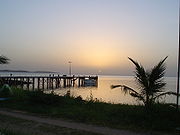
There are three settled areas. One settled area is at the southeast end of the airport. To the north on the west coast is a settled area with a pier and the government center—some locals call this the Mission. Beyond a mountain to the north is a third settled area by Coolgaree Bay.
The islands in the area were named the "Palm Isles" by explorer James Cook
in 1770 as he sailed up the eastern coast of Australia on his first voyage
.
It is estimated that the population of the island at the time of Cook's visit was about 200 Manbarra people.
The name "Great Palm Island" for the island goes back at least as far as 1866.
Beginning in 1918 the island was used by the Queensland Government
as a settlement for Aborigines.
As an end result, the island population is now a mix of Manbarra and other Aboriginal peoples, with few jobs and a shortage of housing.
 At 55 km² (21.2 sq mi), Great Palm Island is nearly twice the size of Norfolk Island
and of a similar size to Magnetic Island
.
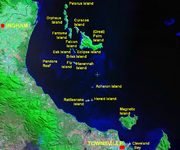
According to a Queensland government source, there are sixteen islands that make up the Greater Palm group.
The majority of these are micro-islands. Major islands within the Greater Palm group are Great Palm Island, Fantome Island
, and Orpheus Island. Notable neighbouring islands outside the Greater Palm group include Rattlesnake Island
, which is used for Air Force
bombing practice, and Magnetic Island
, an island suburb of Townsville.
Topographically, the island is dominated in the center by the tallest peak Mount Bentley, and in the southwest by Mount Lindsay. The surface is covered by rainforest
, with small areas cleared for settlements and the airstrip. The Palm Island airstrip
nestles along a narrow low flatland at the southwest corner of the island.
Surrounding waters include Challenger (Gowyarowa) Bay, which is between Great Palm Island, Curacoa (Noogoo)
, and Fantome Island
s.
Local bays of the island are listed in Table 1.
There are three man-made bodies of fresh water on the island, including Bamboo Dam near the peak of Mount Bentley, and Solomon Dam.
 Great Palm Island is rich in natural beauty, both fauna and flora, however it has been impacted by human settlement and introduced species. Great Palm Island's rich volcanic soil supports tropical flora such as mangrove
s, eucalypt
forest, rainforest
s, hoop pine
, mango
, banana
, pawpaw (papaya)
and wild plum
trees.
The surrounding bays have a diverse marine fauna including coral trout
, crayfish
and coral reef
s.
There has been significant dumping of car bodies and other environmental pollution on the island.
There are hundreds of brumbies
on the island, they are considered to be community-owned.
Many of them have been tortured, starved to death, and beaten by local teenagers. A local Aboriginal, Wayne Coolwell, has been quoted as saying "I don't like to accuse my own people of things like this, but it's self-evident...and cruelty is cruelty, and when you see the photographs and you hear the stories, there's obviously a real problem on that island."
 As an island in northern Queensland
, Great Palm Island is vulnerable to cyclone
s. In March 1997 Cyclone Justin passed over the Cairns coastline and remained near Great Palm Island causing a great deal of flash flood
ing. Peaking at Category 4, at landfall it was a Category 2 cyclone; it caused significant damage in the Cairns region during its relatively long, 3½ week life.
In April 2000 category 2 Cyclone Tessi passed directly over Great Palm Island, but caused little damage.
in the Coral Sea
in the vicinity of Halifax Bay
. The ocean surrounding the island is in the Great Barrier Reef Marine Park
.
Under the zoning authority of the Great Barrier Reef Marine Park Authority (GBRMPA), the ocean on the western side of the island is in a Habitat Protection zone. The rest of the island is surrounded by a Conservation zone. These zones exist to protect the park from excess extraction and fishing.
There are seven named reefs adjacent to the island, known as nearshore fringing reef
s. The designation of the seven varies; for example, the seventh of the seven is called Great Palm Reef (No 7), 18-054G, Great Palm Reef G, and Reef 18054G.
As designated by the GBRMPA, Great Palm Island has the number 18-054, and the seven reefs are a, b, c, d, e, f, and g.
In Table 2 are the ten islands of the Greater Palm group in the jurisdiction
of the Palm Island Aboriginal Shire Council
. Two islands and one rock are in the Hinchinbrook jurisdiction. These are Orpheus (Goolboddi), Pelorus
(Yanooa) or North Palm Island, and Albino Rock. Albino Rock is part of Orpheus Island National Park. The remaining rocks owned by the Commonwealth are in the jurisdiction of the GBRMPA. Table 3 lists additional micro-islands.
Indigenous Australians
Indigenous Australians are the original inhabitants of the Australian continent and nearby islands. The Aboriginal Indigenous Australians migrated from the Indian continent around 75,000 to 100,000 years ago....
name Bwgcolman; is a tropical island with a resident community of about 2,000 people. The island has an area of 55 km² (21.2 sq mi). The official area figure of 70.9 km² refers to Aboriginal Shire of Palm Island and includes nine smaller islands. It is in Queensland
Queensland
Queensland is a state of Australia, occupying the north-eastern section of the mainland continent. It is bordered by the Northern Territory, South Australia and New South Wales to the west, south-west and south respectively. To the east, Queensland is bordered by the Coral Sea and Pacific Ocean...
, Australia
Australia
Australia , officially the Commonwealth of Australia, is a country in the Southern Hemisphere comprising the mainland of the Australian continent, the island of Tasmania, and numerous smaller islands in the Indian and Pacific Oceans. It is the world's sixth-largest country by total area...
, off the east coast of northern Queensland
North Queensland
North Queensland or the Northern Region is the northern part of the state of Queensland in Australia. Queensland is a massive state, larger than most countries, and the tropical northern part of it has been historically remote and undeveloped, resulting in a distinctive regional character and...
, situated 65 kilometres (40.4 mi) northwest of Townsville, and 800 kilometres (497.1 mi) north of the Tropic of Capricorn
Tropic of Capricorn
The Tropic of Capricorn, or Southern tropic, marks the most southerly latitude on the Earth at which the Sun can be directly overhead. This event occurs at the December solstice, when the southern hemisphere is tilted towards the Sun to its maximum extent.Tropic of Capricorn is one of the five...
. The Australia Post
Australia Post
Australia Post is the trading name of the Australian Government-owned Australian Postal Corporation .-History:...
lists the local post office as Palm Island
Palm Island, Queensland
Palm Island is an Aboriginal community located on Great Palm Island, also called by the Aboriginal name "Bwgcolman", an island on the Great Barrier Reef in North Queensland, Australia The settlement is also known by a variety of other names including "the Mission", Palm Island Settlement or Palm...
, QLD. It is the main island of the Greater Palm group, and consists of small bay
Bay
A bay is an area of water mostly surrounded by land. Bays generally have calmer waters than the surrounding sea, due to the surrounding land blocking some waves and often reducing winds. Bays also exist as an inlet in a lake or pond. A large bay may be called a gulf, a sea, a sound, or a bight...
s, sandy beach
Beach
A beach is a geological landform along the shoreline of an ocean, sea, lake or river. It usually consists of loose particles which are often composed of rock, such as sand, gravel, shingle, pebbles or cobblestones...
es and steep forest
Forest
A forest, also referred to as a wood or the woods, is an area with a high density of trees. As with cities, depending where you are in the world, what is considered a forest may vary significantly in size and have various classification according to how and what of the forest is composed...
ed mountains rising to a peak of 548 metres (1,797.9 ft).
Great Barrier Reef Marine Park
The Great Barrier Reef Marine Park protects a large part of Australia's Great Barrier Reef from damaging activities. Fishing and the removal of artefacts or...
where extraction and fishing are regulated.
Human habitation
History of Australia (1788-1850)
The history of Australia from 1788–1850 covers the early colonies period of Australia's history, from the arrival of the First Fleet of British ships at Sydney to establish the penal colony of New South Wales in 1788 to the European exploration of the continent and establishment of other colonies...
.
The local government is the Palm Island Aboriginal Shire Council, which has jurisdiction over ten of the islands in the Greater Palm group.
While the Australia Post lists the local post office as Palm Island, QLD, there is no formal name for the settled areas of the island. Other names include or have included the Mission, Palm Island settlement, Palm Island Aborigines settlement, and Palm Island Community.
There are three settled areas. One settled area is at the southeast end of the airport. To the north on the west coast is a settled area with a pier and the government center—some locals call this the Mission. Beyond a mountain to the north is a third settled area by Coolgaree Bay.
The islands in the area were named the "Palm Isles" by explorer James Cook
James Cook
Captain James Cook, FRS, RN was a British explorer, navigator and cartographer who ultimately rose to the rank of captain in the Royal Navy...
in 1770 as he sailed up the eastern coast of Australia on his first voyage
First voyage of James Cook
The first voyage of James Cook was a combined Royal Navy and Royal Society expedition to the south Pacific ocean aboard HMS Endeavour, from 1768 to 1771...
.
It is estimated that the population of the island at the time of Cook's visit was about 200 Manbarra people.
The name "Great Palm Island" for the island goes back at least as far as 1866.
Beginning in 1918 the island was used by the Queensland Government
Government of Queensland
The Government of Queensland is commonly known as the "Queensland Government".The form of the Government of Queensland is prescribed in its Constitution, which dates from 1859, although it has been amended many times since then...
as a settlement for Aborigines.
As an end result, the island population is now a mix of Manbarra and other Aboriginal peoples, with few jobs and a shortage of housing.
Geography
Norfolk Island
Norfolk Island is a small island in the Pacific Ocean located between Australia, New Zealand and New Caledonia. The island is part of the Commonwealth of Australia, but it enjoys a large degree of self-governance...
and of a similar size to Magnetic Island
Magnetic Island
Magnetic Island is an island offshore from the city of Townsville, Queensland, Australia. This mountainous island in Cleveland Bay has effectively become a suburb of Townsville, with 2,107 permanent residents. The island is accessible from Townsville Breakwater to Nelly Bay Harbour by ferry...
.
According to a Queensland government source, there are sixteen islands that make up the Greater Palm group.
The majority of these are micro-islands. Major islands within the Greater Palm group are Great Palm Island, Fantome Island
Fantome Island
Fantome Island is one of the islands in the Great Palm Island group. It is neighboured by Great Palm Island and is north-east of Townsville, Queensland on the east coast of Australia. The Aboriginal name for this island is Eumilli Island. The island is small with an area of and is surrounded by...
, and Orpheus Island. Notable neighbouring islands outside the Greater Palm group include Rattlesnake Island
Rattlesnake Island, Queensland
Rattlesnake Island is one of the islands South of the Great Palm Island group, northwest of Magnetic Island and directly east of Rollingstone in the Halifax Bay....
, which is used for Air Force
Royal Australian Air Force
The Royal Australian Air Force is the air force branch of the Australian Defence Force. The RAAF was formed in March 1921. It continues the traditions of the Australian Flying Corps , which was formed on 22 October 1912. The RAAF has taken part in many of the 20th century's major conflicts...
bombing practice, and Magnetic Island
Magnetic Island
Magnetic Island is an island offshore from the city of Townsville, Queensland, Australia. This mountainous island in Cleveland Bay has effectively become a suburb of Townsville, with 2,107 permanent residents. The island is accessible from Townsville Breakwater to Nelly Bay Harbour by ferry...
, an island suburb of Townsville.
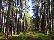
Topographically, the island is dominated in the center by the tallest peak Mount Bentley, and in the southwest by Mount Lindsay. The surface is covered by rainforest
Rainforest
Rainforests are forests characterized by high rainfall, with definitions based on a minimum normal annual rainfall of 1750-2000 mm...
, with small areas cleared for settlements and the airstrip. The Palm Island airstrip
Palm Island Airport
Palm Island Airport is an airport in Palm Island, Queensland, Australia.- Aerial photos and maps :...
nestles along a narrow low flatland at the southwest corner of the island.
Surrounding waters include Challenger (Gowyarowa) Bay, which is between Great Palm Island, Curacoa (Noogoo)
Curacoa Island
Curacoa Island is one of the islands in the Great Palm Island group. The nearest island is Great Palm Island, after which the group is named. Curacoa Island is uninhabited.The Aboriginal term for this island is Noogoo Island.-External links:*...
, and Fantome Island
Fantome Island
Fantome Island is one of the islands in the Great Palm Island group. It is neighboured by Great Palm Island and is north-east of Townsville, Queensland on the east coast of Australia. The Aboriginal name for this island is Eumilli Island. The island is small with an area of and is surrounded by...
s.
Local bays of the island are listed in Table 1.
| Bay | Notes |
|---|---|
| Cannon (Numbullabudgee) | by Wallaby (Nullaree) Point |
| Bullumbooroo | |
| North East (Othoorakool) | |
| Barber | within view of Barber (Boodthean) Island |
| Mundy | |
| Butler (Surrumbroo) | at the southeast end of the airport |
| Pencil | |
| Casement | at the northwest end of the airport |
| Regina | |
| Coolgood | has a pier, a settled area is inland |
| Coolgaree Bay | a settled area is inland |
There are three man-made bodies of fresh water on the island, including Bamboo Dam near the peak of Mount Bentley, and Solomon Dam.
Natural environment and cyclones
Mangrove
Mangroves are various kinds of trees up to medium height and shrubs that grow in saline coastal sediment habitats in the tropics and subtropics – mainly between latitudes N and S...
s, eucalypt
Eucalyptus
Eucalyptus is a diverse genus of flowering trees in the myrtle family, Myrtaceae. Members of the genus dominate the tree flora of Australia...
forest, rainforest
Rainforest
Rainforests are forests characterized by high rainfall, with definitions based on a minimum normal annual rainfall of 1750-2000 mm...
s, hoop pine
Araucaria cunninghamii
Araucaria cunninghamii is a species of Araucaria known as Moreton Bay Pine, or Hoop Pine. Other less commonly used names include Colonial Pine, Richmond River Pine, Queensland Pine, Alloa, Ningwik, or Pien, the wood is sometimes called Arakaria)...
, mango
Mango
The mango is a fleshy stone fruit belonging to the genus Mangifera, consisting of numerous tropical fruiting trees in the flowering plant family Anacardiaceae. The mango is native to India from where it spread all over the world. It is also the most cultivated fruit of the tropical world. While...
, banana
Banana
Banana is the common name for herbaceous plants of the genus Musa and for the fruit they produce. Bananas come in a variety of sizes and colors when ripe, including yellow, purple, and red....
, pawpaw (papaya)
Papaya
The papaya , papaw, or pawpaw is the fruit of the plant Carica papaya, the sole species in the genus Carica of the plant family Caricaceae...
and wild plum
Plum
A plum or gage is a stone fruit tree in the genus Prunus, subgenus Prunus. The subgenus is distinguished from other subgenera in the shoots having a terminal bud and solitary side buds , the flowers in groups of one to five together on short stems, and the fruit having a groove running down one...
trees.
The surrounding bays have a diverse marine fauna including coral trout
Trout
Trout is the name for a number of species of freshwater and saltwater fish belonging to the Salmoninae subfamily of the family Salmonidae. Salmon belong to the same family as trout. Most salmon species spend almost all their lives in salt water...
, crayfish
Crayfish
Crayfish, crawfish, or crawdads – members of the superfamilies Astacoidea and Parastacoidea – are freshwater crustaceans resembling small lobsters, to which they are related...
and coral reef
Coral reef
Coral reefs are underwater structures made from calcium carbonate secreted by corals. Coral reefs are colonies of tiny living animals found in marine waters that contain few nutrients. Most coral reefs are built from stony corals, which in turn consist of polyps that cluster in groups. The polyps...
s.
There has been significant dumping of car bodies and other environmental pollution on the island.
There are hundreds of brumbies
Brumby
A Brumby is a free-roaming feral horse in Australia. Although found in many areas around the country, the best-known brumbies are found in the Australian Alps region in south-eastern Australia. Today, most of them are found in the Northern Territory, with the second largest population in Queensland...
on the island, they are considered to be community-owned.
Many of them have been tortured, starved to death, and beaten by local teenagers. A local Aboriginal, Wayne Coolwell, has been quoted as saying "I don't like to accuse my own people of things like this, but it's self-evident...and cruelty is cruelty, and when you see the photographs and you hear the stories, there's obviously a real problem on that island."
North Queensland
North Queensland or the Northern Region is the northern part of the state of Queensland in Australia. Queensland is a massive state, larger than most countries, and the tropical northern part of it has been historically remote and undeveloped, resulting in a distinctive regional character and...
, Great Palm Island is vulnerable to cyclone
Cyclone
In meteorology, a cyclone is an area of closed, circular fluid motion rotating in the same direction as the Earth. This is usually characterized by inward spiraling winds that rotate anticlockwise in the Northern Hemisphere and clockwise in the Southern Hemisphere of the Earth. Most large-scale...
s. In March 1997 Cyclone Justin passed over the Cairns coastline and remained near Great Palm Island causing a great deal of flash flood
Flash flood
A flash flood is a rapid flooding of geomorphic low-lying areas—washes, rivers, dry lakes and basins. It may be caused by heavy rain associated with a storm, hurricane, or tropical storm or meltwater from ice or snow flowing over ice sheets or snowfields...
ing. Peaking at Category 4, at landfall it was a Category 2 cyclone; it caused significant damage in the Cairns region during its relatively long, 3½ week life.
In April 2000 category 2 Cyclone Tessi passed directly over Great Palm Island, but caused little damage.
The surrounding ocean
Great Palm Island is inside the Great Barrier ReefGreat Barrier Reef
The Great Barrier Reef is the world'slargest reef system composed of over 2,900 individual reefs and 900 islands stretching for over 2,600 kilometres over an area of approximately...
in the Coral Sea
Coral Sea
The Coral Sea is a marginal sea off the northeast coast of Australia. It is bounded in the west by the east coast of Queensland, thereby including the Great Barrier Reef, in the east by Vanuatu and by New Caledonia, and in the north approximately by the southern extremity of the Solomon Islands...
in the vicinity of Halifax Bay
Halifax Bay
Halifax Bay is a region located around a bay in the Coral Sea, situated on the Australian coast in Far North Queensland. It is bordered by the town of Ingham to the north, city of Townsville to the south and Great Palm Island off the coast to the east....
. The ocean surrounding the island is in the Great Barrier Reef Marine Park
Great Barrier Reef Marine Park
The Great Barrier Reef Marine Park protects a large part of Australia's Great Barrier Reef from damaging activities. Fishing and the removal of artefacts or...
.
Under the zoning authority of the Great Barrier Reef Marine Park Authority (GBRMPA), the ocean on the western side of the island is in a Habitat Protection zone. The rest of the island is surrounded by a Conservation zone. These zones exist to protect the park from excess extraction and fishing.
There are seven named reefs adjacent to the island, known as nearshore fringing reef
Fringing reef
A fringing reef is one of the three main types of coral reefs recognized by most coral reef scientists. It is distinguished from the other two main types in that it has either an entirely shallow backreef zone or none at all...
s. The designation of the seven varies; for example, the seventh of the seven is called Great Palm Reef (No 7), 18-054G, Great Palm Reef G, and Reef 18054G.
As designated by the GBRMPA, Great Palm Island has the number 18-054, and the seven reefs are a, b, c, d, e, f, and g.
Greater Palm group
Great Palm Island is the largest of the islands in the Greater Palm group. While originally named the "Palm Isles", many names are currently used for the group. Great Palm Island group and Palm Islands are two such names. The nearest island to the group is Pandora Reef.In Table 2 are the ten islands of the Greater Palm group in the jurisdiction
Local Government Area
A local government area is an administrative division of a country that a local government is responsible for. The size of an LGA varies by country but it is generally a subdivision of a state, province, division, or territory....
of the Palm Island Aboriginal Shire Council
Palm Island Aboriginal Shire Council
The Aboriginal Shire of Palm Island is a special Local Government Area of Queensland, Australia, managed by the Palm Island Aboriginal Shire Council under a Deed of Grant in Trust granted to the community on 27 October 1986. It is located on Palm Island, near the north Queensland city of...
. Two islands and one rock are in the Hinchinbrook jurisdiction. These are Orpheus (Goolboddi), Pelorus
Pelorus Island
Pelorus Island is the northernmost island of the Great Palm Island group. It is located 800 meters north of Orpheus Island. Pelorus is surrounded by spectacular fringing reefs that can be accessed by snorkeling right off the beach...
(Yanooa) or North Palm Island, and Albino Rock. Albino Rock is part of Orpheus Island National Park. The remaining rocks owned by the Commonwealth are in the jurisdiction of the GBRMPA. Table 3 lists additional micro-islands.
| Island name | Aboriginal name | Group size | Brushfire risk | GBRMPA reef designation |
|---|---|---|---|---|
| Curra-cao or Curacoa Island Curacoa Island Curacoa Island is one of the islands in the Great Palm Island group. The nearest island is Great Palm Island, after which the group is named. Curacoa Island is uninhabited.The Aboriginal term for this island is Noogoo Island.-External links:*... |
Noogoo or Inoogoo | major | medium | 18-052 |
| Fantome Island Fantome Island Fantome Island is one of the islands in the Great Palm Island group. It is neighboured by Great Palm Island and is north-east of Townsville, Queensland on the east coast of Australia. The Aboriginal name for this island is Eumilli Island. The island is small with an area of and is surrounded by... |
Eumilli | major | medium | 18-053 |
| Great Palm Island or Palm Island | Bwgcolman | major | high | 18-054 |
| Havannah Island Havannah Island Havannah Island is one of the islands in the Great Palm Island group. The nearest island is Great Palm Island, after which the group is named.Havannah Island is the southernmost island from Palm Island and is under the flight path from Townsville.... |
major | medium | 18-065 | |
| Brisk Island Brisk Island Brisk Island is an island in the Great Palm Island group. The nearest island is Great Palm Island, after which the group is named.The Aboriginal name for Brisk Island is Culgarool Island.... |
Culgarool | micro-island | medium | shared with Falcon Island |
| Eclipse Island | Garoogubbee | micro-island | not rated | 18-058 |
| Esk Island Esk Island Esk Island is one of the islands in the Great Palm Island group. The nearest island is Great Palm Island, after which the group is named.The Aboriginal term for this island is Soopun Island.... |
Soopun | micro-island | not rated | 18-059 |
| Barber Island | Boodthean | micro-island | not rated | 18-061 |
| Falcon Island Falcon Island Falcon Island is one of the islands in the Great Palm Island group, off the eastern coast of Queensland, Australia. The nearest island is Great Palm Island, after which the group is named.The Aboriginal term for this island is Carbooroo Island.... |
Carbooroo | micro-island | not rated | 18-062 |
| Fly Island Fly Island Fly Island is one of the islands in the Great Palm Island group. The nearest island is Great Palm Island, after which the group is named.Fly Island is a few hundred metres northwest of Havannah Island and 50 km southeast of Ingham. The nearest island to the west is Pandora Reef.- References :... |
micro-island | not rated | 18-064 |
| Island name | GBRMPA reef designation |
|---|---|
| Paluma Rock | 18-056 |
| Albino Rock (AKA White Rock) | 18-057 |
| Dido Rock | 18-060 |
| Chilcott Rocks | 18-063 |
| Hayman Rock. | |