
Magnetic Island
Encyclopedia
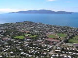
Magnetic Island is an island 8 kilometres (5 mi) offshore from the city of Townsville, Queensland
, Australia. This 52 km² (20.1 sq mi) mountainous island in Cleveland Bay has effectively become a suburb of Townsville, with 2,107 permanent residents. The island is accessible from Townsville Breakwater to Nelly Bay Harbour by ferry. There is a large 27 km² (10.4 sq mi) World Heritage National Park and bird sanctuary and excellent walking tracks can be taken between the populated bays and to a number of tourist destinations such as the World War II
forts.
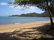
The island has long become established as a holiday destination with many hotels and several resorts in operation to cater for all levels of service. The public facilities and infrastructure on the island are managed by the Townsville City Council. The island is part of the Electoral district of Townsville
in the Queensland Legislative Assembly
. The island is also part of the Federal seat of Herbert
, which is represented by Ewan Jones.
as he passed the island when sailing up the east coast of Australia in 1770. People have since explored the general area of Magnetic Island with various instruments to discover what might have caused the effect that Cook reported, but nothing has been discovered.
, which is mostly located on the steep hilly interior and rugged north-western side. The highest point on the island is Mount Cook reaching 497 m (1,630.6 ft) above sea level.
Magnetic Island is famous for its angling opportunities. Fish around the island include: Blue and Black Marlin, Sailfish, Mackerel, Wahoo, Giant Trevally, Dogtooth Tuna, Coral Trout, Mahi Mahi, Tuna, Red Emperor and Sea Perch.
The pressure of coastal development has, in recent years, begun to make a significant impact on the island, which lies in the World Heritage listed Great Barrier Reef Marine Park
. At present many millions of dollars in development are planned for the island and the impact of these has led to considerable opposition from some residents who fear the effects this development will have on the environmental values of Magnetic's lowlands which are not protected by the national park; these areas represent only 20% of the whole island, and of this 20%, most is freehold land and is already developed.
well before European exploration of the area. These populations were known to have permanent camps at a number of bays, and had the ability to travel to the mainland using canoes. A number of Aboriginal burial sites are known to exist on the island, but have so far not been discovered by European development or exploration of the island. Aboriginal middens and cave drawings can still be found in a number of bays around Magnetic Island. Folklore of the Wulguru tribe, who inhabited the island, recounts a long history of inhabitation and annual migration to the mainland to avoid the traveling tribes from Papua New Guinea
and the Torres Strait
, who used the northern trade winds to travel south from their native lands in order to head-hunt indigenous tribes along the northern coasts of Australia. This head-hunting activity near-ceased following the arrival of missionaries, led by Samual MacFarlane to the Torres Straits in 1871.
The first European accounts of the island come from Captain James Cook
who, in 1770, while navigating the Australian coast, called the island Magnetical Island, as a magnetic pull interfering with his vessel's compass appeared to emanate from the island. J.M. Black, funded by Robert Towns
, founded the township of Townsville on the mainland nearby. As Townsville developed though the mid-19th century, Magnetic Island became a valuable location for the gathering of hoop pine
and granite
, the latter of which was used in the reclamation of land for the Port of Townsville, and for construction of Townsville's Customs House.
was named after its popularity as a picnic spot for European tourists from the mainland during the 19th century, before Magnetic Island was first inhabited by Europeans. In the mid-19th century the island became a popular location for the collection of stone and coral needed for development on the mainland. In 1875 the island was set aside as a quarantine
station although it took another ten years for the proper facilities to be set up at West Point.
By 1890 a resort had been started in Picnic Bay. In 1898 Robert Hayles Sn. was so impressed by the potential of Magnetic Island he sold his other interests to build a resort on the island. Hayles was responsible for much of the development of Magnetic Island through tourism. In 1901 he started a regular ferry service to the island with his ship the Bee. Twelve months later this ship was wrecked on the rocks at Nobby Head, Picnic Bay and the Phoenix was built by Hayles' sons to replace the vessel. The Hayles company remained operating services to Magnetic Island with a large number of different vessels until the 1970s.
due to its proximity to Townsville, an important military base, and its views over Cleveland Bay, a significant anchorage and assembly point for large fleets and convoys operating in the south Pacific. As such, the Magnetic Battery
, an artillery battery and observation post, was built in the hinterland of Florence, Horseshoe and Arthur Bays. Picnic Bay also became a popular defence force rest and relaxation camp following the commandeering of a resort in the bay in 1939.
 The four villages of the island, which contain the lion's share of the population of 2107 (as of the census of population 2006) are all located in the eastern part along the coast, from north to south: Horseshoe Bay
, Arcadia Bay
, Nelly Bay
, Picnic Bay
. Additionally, there is a small settlement West Point, that stretches southward from the namesake West Point of the island and contains the remaining 35 inhabitants.
• Bay Days Festival (September - October)
Queensland
Queensland is a state of Australia, occupying the north-eastern section of the mainland continent. It is bordered by the Northern Territory, South Australia and New South Wales to the west, south-west and south respectively. To the east, Queensland is bordered by the Coral Sea and Pacific Ocean...
, Australia. This 52 km² (20.1 sq mi) mountainous island in Cleveland Bay has effectively become a suburb of Townsville, with 2,107 permanent residents. The island is accessible from Townsville Breakwater to Nelly Bay Harbour by ferry. There is a large 27 km² (10.4 sq mi) World Heritage National Park and bird sanctuary and excellent walking tracks can be taken between the populated bays and to a number of tourist destinations such as the World War II
World War II
World War II, or the Second World War , was a global conflict lasting from 1939 to 1945, involving most of the world's nations—including all of the great powers—eventually forming two opposing military alliances: the Allies and the Axis...
forts.
The island has long become established as a holiday destination with many hotels and several resorts in operation to cater for all levels of service. The public facilities and infrastructure on the island are managed by the Townsville City Council. The island is part of the Electoral district of Townsville
Electoral district of Townsville
The district of Townsville is an electoral district of the Legislative Assembly in the Australian state of Queensland. The seat is one of four within the Townsville urban area in North Queensland, and covers the Eastern and Northern suburbs of the City of Townsville as well as Magnetic Island and...
in the Queensland Legislative Assembly
Queensland Legislative Assembly
The Queensland Legislative Assembly is the unicameral chamber of the Parliament of Queensland. Elections are held approximately once every three years. Voting is by the Optional Preferential Voting form of the Alternative Vote system...
. The island is also part of the Federal seat of Herbert
Division of Herbert
The Division of Herbert is an Australian Electoral Division in Queensland. Eligible voters within the Division elect a single representative, known as the member for Herbert, to the Australian House of Representatives. The division was first contested at the 1901 election...
, which is represented by Ewan Jones.
Naming
The name of the island came about because of the apparent "magnetic" effect it had on the ship's compass of Captain CookJames Cook
Captain James Cook, FRS, RN was a British explorer, navigator and cartographer who ultimately rose to the rank of captain in the Royal Navy...
as he passed the island when sailing up the east coast of Australia in 1770. People have since explored the general area of Magnetic Island with various instruments to discover what might have caused the effect that Cook reported, but nothing has been discovered.
Natural heritage
The island is a haven for wildlife. 54% of the island is Magnetic Island National ParkMagnetic Island National Park
Magnetic Island is a national park in Queensland, Australia, 1122 km northwest of Brisbane, lying just off the coast from the city of Townsville. It occupies more than half of the area of Magnetic Island. Most of the park is in the western part of the island....
, which is mostly located on the steep hilly interior and rugged north-western side. The highest point on the island is Mount Cook reaching 497 m (1,630.6 ft) above sea level.
Magnetic Island is famous for its angling opportunities. Fish around the island include: Blue and Black Marlin, Sailfish, Mackerel, Wahoo, Giant Trevally, Dogtooth Tuna, Coral Trout, Mahi Mahi, Tuna, Red Emperor and Sea Perch.
The pressure of coastal development has, in recent years, begun to make a significant impact on the island, which lies in the World Heritage listed Great Barrier Reef Marine Park
Great Barrier Reef Marine Park
The Great Barrier Reef Marine Park protects a large part of Australia's Great Barrier Reef from damaging activities. Fishing and the removal of artefacts or...
. At present many millions of dollars in development are planned for the island and the impact of these has led to considerable opposition from some residents who fear the effects this development will have on the environmental values of Magnetic's lowlands which are not protected by the national park; these areas represent only 20% of the whole island, and of this 20%, most is freehold land and is already developed.
Pre-European settlement
Yunbunam, as Magnetic Island was known by the island's traditional inhabitants, had a semi-permanent population of Australian AboriginesAustralian Aborigines
Australian Aborigines , also called Aboriginal Australians, from the latin ab originem , are people who are indigenous to most of the Australian continentthat is, to mainland Australia and the island of Tasmania...
well before European exploration of the area. These populations were known to have permanent camps at a number of bays, and had the ability to travel to the mainland using canoes. A number of Aboriginal burial sites are known to exist on the island, but have so far not been discovered by European development or exploration of the island. Aboriginal middens and cave drawings can still be found in a number of bays around Magnetic Island. Folklore of the Wulguru tribe, who inhabited the island, recounts a long history of inhabitation and annual migration to the mainland to avoid the traveling tribes from Papua New Guinea
Papua New Guinea
Papua New Guinea , officially the Independent State of Papua New Guinea, is a country in Oceania, occupying the eastern half of the island of New Guinea and numerous offshore islands...
and the Torres Strait
Torres Strait
The Torres Strait is a body of water which lies between Australia and the Melanesian island of New Guinea. It is approximately wide at its narrowest extent. To the south is Cape York Peninsula, the northernmost continental extremity of the Australian state of Queensland...
, who used the northern trade winds to travel south from their native lands in order to head-hunt indigenous tribes along the northern coasts of Australia. This head-hunting activity near-ceased following the arrival of missionaries, led by Samual MacFarlane to the Torres Straits in 1871.
The first European accounts of the island come from Captain James Cook
James Cook
Captain James Cook, FRS, RN was a British explorer, navigator and cartographer who ultimately rose to the rank of captain in the Royal Navy...
who, in 1770, while navigating the Australian coast, called the island Magnetical Island, as a magnetic pull interfering with his vessel's compass appeared to emanate from the island. J.M. Black, funded by Robert Towns
Robert Towns
Robert Towns was an Australian businessman, pastoralist, and founder of Townsville, Queensland.Towns was born at Longhorsley, Northumberland, England, on 10 November 1794. This is the date usually given, and it agrees with his death notice in the Sydney Morning Herald of 12 April 1873 which stated...
, founded the township of Townsville on the mainland nearby. As Townsville developed though the mid-19th century, Magnetic Island became a valuable location for the gathering of hoop pine
Araucaria cunninghamii
Araucaria cunninghamii is a species of Araucaria known as Moreton Bay Pine, or Hoop Pine. Other less commonly used names include Colonial Pine, Richmond River Pine, Queensland Pine, Alloa, Ningwik, or Pien, the wood is sometimes called Arakaria)...
and granite
Granite
Granite is a common and widely occurring type of intrusive, felsic, igneous rock. Granite usually has a medium- to coarse-grained texture. Occasionally some individual crystals are larger than the groundmass, in which case the texture is known as porphyritic. A granitic rock with a porphyritic...
, the latter of which was used in the reclamation of land for the Port of Townsville, and for construction of Townsville's Customs House.
European settlement and development
Picnic BayPicnic Bay, Queensland
Picnic Bay refers to both a bay on the south-east corner of Magnetic Island and the island's main town. At the 2006 census, Picnic Bay had a population of 360....
was named after its popularity as a picnic spot for European tourists from the mainland during the 19th century, before Magnetic Island was first inhabited by Europeans. In the mid-19th century the island became a popular location for the collection of stone and coral needed for development on the mainland. In 1875 the island was set aside as a quarantine
Quarantine
Quarantine is compulsory isolation, typically to contain the spread of something considered dangerous, often but not always disease. The word comes from the Italian quarantena, meaning forty-day period....
station although it took another ten years for the proper facilities to be set up at West Point.
By 1890 a resort had been started in Picnic Bay. In 1898 Robert Hayles Sn. was so impressed by the potential of Magnetic Island he sold his other interests to build a resort on the island. Hayles was responsible for much of the development of Magnetic Island through tourism. In 1901 he started a regular ferry service to the island with his ship the Bee. Twelve months later this ship was wrecked on the rocks at Nobby Head, Picnic Bay and the Phoenix was built by Hayles' sons to replace the vessel. The Hayles company remained operating services to Magnetic Island with a large number of different vessels until the 1970s.
World War II
Magnetic Island became an important defensive position during World War IIWorld War II
World War II, or the Second World War , was a global conflict lasting from 1939 to 1945, involving most of the world's nations—including all of the great powers—eventually forming two opposing military alliances: the Allies and the Axis...
due to its proximity to Townsville, an important military base, and its views over Cleveland Bay, a significant anchorage and assembly point for large fleets and convoys operating in the south Pacific. As such, the Magnetic Battery
Magnetic Battery
The Magnetic Battery, Fort War or The Forts, as it is commonly referred, is a former Australian Royal Navy artillery battery in the hinterland of Horseshoe. Florence and Arthur Bays on Magnetic Island. Built in 1942/43 the battery operated from July 1943 until the end of World War II...
, an artillery battery and observation post, was built in the hinterland of Florence, Horseshoe and Arthur Bays. Picnic Bay also became a popular defence force rest and relaxation camp following the commandeering of a resort in the bay in 1939.
Post-war era
The island slowly expanded following the end of the Second World War. In late December 1971 Cyclone Althea hit the North Queensland coast directly crossing Magnetic Island. The island, along with much of the mainland, was devastated with 90% of the island's houses damaged or destroyed, some simply lifted off their foundations and tossed into trees. The island, along with the mainland, soon recovered.Villages
Horseshoe Bay, Queensland
Horseshoe Bay is a village on Magnetic Island, Queensland, Australia. It is considered the tourist strip of the island. From September 2006, Horseshoe Bay was undergoing a string of housing development behind the existing residential area to the southern part of the bay. It is also a major...
, Arcadia Bay
Arcadia, Queensland
Arcadia is a village and town on Magnetic Island, Australia. Arcadia is more residential focused with around 97% of the dwellings being Housing or unit type dwellings....
, Nelly Bay
Nelly Bay, Queensland
Nelly Bay is a village on Magnetic Island, and a suburb of the City of Townsville, Australia. A tourism hub on the island, it is especially significant as the site of the ferry terminal, which links it to Townsville...
, Picnic Bay
Picnic Bay, Queensland
Picnic Bay refers to both a bay on the south-east corner of Magnetic Island and the island's main town. At the 2006 census, Picnic Bay had a population of 360....
. Additionally, there is a small settlement West Point, that stretches southward from the namesake West Point of the island and contains the remaining 35 inhabitants.
| Nr. | Community | Area km² |
Population 2006 |
Population Density |
|---|---|---|---|---|
| 1 | Horseshoe Bay Horseshoe Bay, Queensland Horseshoe Bay is a village on Magnetic Island, Queensland, Australia. It is considered the tourist strip of the island. From September 2006, Horseshoe Bay was undergoing a string of housing development behind the existing residential area to the southern part of the bay. It is also a major... |
9.7 | 484 | 49.9 |
| 2 | Arcadia Bay Arcadia, Queensland Arcadia is a village and town on Magnetic Island, Australia. Arcadia is more residential focused with around 97% of the dwellings being Housing or unit type dwellings.... |
5.2 | 257 | 49.4 |
| 3 | Nelly Bay Nelly Bay, Queensland Nelly Bay is a village on Magnetic Island, and a suburb of the City of Townsville, Australia. A tourism hub on the island, it is especially significant as the site of the ferry terminal, which links it to Townsville... |
5.2 | 973 | 187.1 |
| 4 | Picnic Bay Picnic Bay, Queensland Picnic Bay refers to both a bay on the south-east corner of Magnetic Island and the island's main town. At the 2006 census, Picnic Bay had a population of 360.... |
2.8 | 359 | 128.2 |
| 5 | West Point | 28.4 | 35 | 1.2 |
| Magnetic Island | 51.3 | 2107 | 41.1 |
Annual events
Annual events include:- Great Tropical Jazz Party (August)
• Bay Days Festival (September - October)