

Geology of Gloucestershire
Encyclopedia
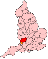
Gloucestershire
Gloucestershire is a county in South West England. The county comprises part of the Cotswold Hills, part of the flat fertile valley of the River Severn, and the entire Forest of Dean....
is one of the most geologically
Geology
Geology is the science comprising the study of solid Earth, the rocks of which it is composed, and the processes by which it evolves. Geology gives insight into the history of the Earth, as it provides the primary evidence for plate tectonics, the evolutionary history of life, and past climates...
and scenically diverse counties in England
England
England is a country that is part of the United Kingdom. It shares land borders with Scotland to the north and Wales to the west; the Irish Sea is to the north west, the Celtic Sea to the south west, with the North Sea to the east and the English Channel to the south separating it from continental...
, with rocks from the Precambrian
Precambrian
The Precambrian is the name which describes the large span of time in Earth's history before the current Phanerozoic Eon, and is a Supereon divided into several eons of the geologic time scale...
through to the Jurassic
Jurassic
The Jurassic is a geologic period and system that extends from about Mya to Mya, that is, from the end of the Triassic to the beginning of the Cretaceous. The Jurassic constitutes the middle period of the Mesozoic era, also known as the age of reptiles. The start of the period is marked by...
represented. These varying rock-types are responsible for the three major areas of the county, each with its own distinctive scenery and land-use - the Forest of Dean
Forest of Dean
The Forest of Dean is a geographical, historical and cultural region in the western part of the county of Gloucestershire, England. The forest is a roughly triangular plateau bounded by the River Wye to the west and north, the River Severn to the south, and the City of Gloucester to the east.The...
in the west, bordering Wales
Wales
Wales is a country that is part of the United Kingdom and the island of Great Britain, bordered by England to its east and the Atlantic Ocean and Irish Sea to its west. It has a population of three million, and a total area of 20,779 km²...
, the Cotswolds
Cotswolds
The Cotswolds are a range of hills in west-central England, sometimes called the Heart of England, an area across and long. The area has been designated as the Cotswold Area of Outstanding Natural Beauty...
in the east, and in between, the Severn Vale.
Forest of Dean
The Forest of DeanForest of Dean
The Forest of Dean is a geographical, historical and cultural region in the western part of the county of Gloucestershire, England. The forest is a roughly triangular plateau bounded by the River Wye to the west and north, the River Severn to the south, and the City of Gloucester to the east.The...
, situated between the rivers Severn and Wye
River Wye
The River Wye is the fifth-longest river in the UK and for parts of its length forms part of the border between England and Wales. It is important for nature conservation and recreation.-Description:...
, is formed of a raised basin of palaeozoic rocks folded in the Variscan Orogeny
Variscan orogeny
The Variscan orogeny is a geologic mountain-building event caused by Late Paleozoic continental collision between Euramerica and Gondwana to form the supercontinent of Pangaea.-Naming:...
, similar to the South Wales coalfield
South Wales Coalfield
The South Wales Coalfield is a large region of south Wales that is rich with coal deposits, especially the South Wales Valleys.-The coalfield area:...
to the west. Underlain by great thicknesses of the Old Red Sandstone
Old Red Sandstone
The Old Red Sandstone is a British rock formation of considerable importance to early paleontology. For convenience the short version of the term, 'ORS' is often used in literature on the subject.-Sedimentology:...
, the basin is filled with Carboniferous
Carboniferous
The Carboniferous is a geologic period and system that extends from the end of the Devonian Period, about 359.2 ± 2.5 Mya , to the beginning of the Permian Period, about 299.0 ± 0.8 Mya . The name is derived from the Latin word for coal, carbo. Carboniferous means "coal-bearing"...
limestones, sandstones and coal measures
Forest of Dean Coalfield
The Forest of Dean Coalfield, lying under the Forest of Dean, in northwest Gloucestershire, is one of the smaller coalfields in the British Isles, although intensive mining during the 19th and 20th centuries has had enormous influence on the landscape, history, culture and economy of the area.For...
- all of which have contributed to the industrial history of the region. Sometimes called ‘the prettiest coal-field in Britain’, the Forest’s main coal output was in the 18th, 19th and early 20th centuries, although for hundreds of years coal has been won in the area via ‘free-mines’, which could only be operated by local people known as Freeminer
Freeminer
Freeminer is an ancient title given to a coal or iron miners in the Forest of Dean, Gloucestershire, England, who have earned the right to mine personal plots, known as gales.-History of Freemining:...
s. One or two survive today. Small-scale mining has been enabled by the exposed nature of the coalfield, with seams often outcropping at surface. Iron-ore has been extracted from labyrinthine mines or 'Scowles' in the limestone since at least Roman
Ancient Rome
Ancient Rome was a thriving civilization that grew on the Italian Peninsula as early as the 8th century BC. Located along the Mediterranean Sea and centered on the city of Rome, it expanded to one of the largest empires in the ancient world....
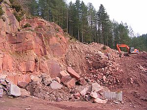
times. Several large quarries are still at work in the area, providing Carboniferous limestone for road surfacing and also Pennant sandstone
Sandstone
Sandstone is a sedimentary rock composed mainly of sand-sized minerals or rock grains.Most sandstone is composed of quartz and/or feldspar because these are the most common minerals in the Earth's crust. Like sand, sandstone may be any colour, but the most common colours are tan, brown, yellow,...
(see picture) - a popular building stone used notably by Thomas Telford
Thomas Telford
Thomas Telford FRS, FRSE was a Scottish civil engineer, architect and stonemason, and a noted road, bridge and canal builder.-Early career:...
for the Over road bridge
Over Bridge
Over Bridge is a single span stone arch bridge spanning the canalised West Channel of the River Severn near Gloucester. It links Over to Alney Island....
, spanning the River Severn
River Severn
The River Severn is the longest river in Great Britain, at about , but the second longest on the British Isles, behind the River Shannon. It rises at an altitude of on Plynlimon, Ceredigion near Llanidloes, Powys, in the Cambrian Mountains of mid Wales...
near Gloucester
Gloucester
Gloucester is a city, district and county town of Gloucestershire in the South West region of England. Gloucester lies close to the Welsh border, and on the River Severn, approximately north-east of Bristol, and south-southwest of Birmingham....
.
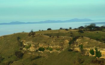
Wye Valley
The Wye Valley Area of Outstanding Natural Beauty is an internationally important protected landscape straddling the border between England and Wales. It is one of the most dramatic and scenic landscape areas in southern Britain....
defines the western edge of Dean as well as the England/Wales border. Impressive cliffs have been cut by the river in lower Dolomitic sections of the Carboniferous Limestone
Carboniferous limestone
Carboniferous Limestone is a term used to describe a variety of different types of limestone occurring widely across Great Britain and Ireland which were deposited during the Dinantian epoch of the Carboniferous period. They were formed between 363 and 325 million years ago...
, most notably at the popular ‘Symonds Yat
Symonds Yat
Symonds Yat is a village in the Forest of Dean and a popular tourist destination, straddling the River Wye and the borders of the English counties of Herefordshire and Gloucestershire, it is within a few miles of the Welsh border...
’ viewpoint, which affords one of the most famous views in England. Other ‘Karst
KARST
Kilometer-square Area Radio Synthesis Telescope is a Chinese telescope project to which FAST is a forerunner. KARST is a set of large spherical reflectors on karst landforms, which are bowlshaped limestone sinkholes named after the Kras region in Slovenia and Northern Italy. It will consist of...
’ features such as caves, rock pillars and sink holes abound in this area.
On the north-east edge of Dean the Silurian
Silurian
The Silurian is a geologic period and system that extends from the end of the Ordovician Period, about 443.7 ± 1.5 Mya , to the beginning of the Devonian Period, about 416.0 ± 2.8 Mya . As with other geologic periods, the rock beds that define the period's start and end are well identified, but the...
period is represented by the distinctive inlier of May Hill
May Hill
May Hill is a hill between Gloucester and Ross-on-Wye, whose summit is on the western edge of Gloucestershire, though its northern slopes are in Herefordshire....
, which rises to some 970 feet, crowned with a pine plantation. This isolated hill lies on the north-south Malvern
Malvern Hills
The Malvern Hills are a range of hills in the English counties of Worcestershire, Herefordshire and a small area of northern Gloucestershire, dominating the surrounding countryside and the towns and villages of the district of Malvern...
fault line and affords superb views from its summit of the Severn Vale, with the Cotswolds forming the horizon beyond. A high degree of faulting complicates the geology of the May Hill area, causing outcrops of Wenlock limestone and Downton Castle sandstone on its flanks, as well as a possibly Precambrian section of the core of the hill exposed at Huntley quarry. The hilltop is of Llandovery age May Hill sandstone.
Severn Vale
To the east is the wide fertile Severn Vale, floored by TriassicTriassic
The Triassic is a geologic period and system that extends from about 250 to 200 Mya . As the first period of the Mesozoic Era, the Triassic follows the Permian and is followed by the Jurassic. Both the start and end of the Triassic are marked by major extinction events...
'New Red' sandstones and marls of the Mercia Mudstones group (formerly known as the 'Keuper
Keuper
The Keuper is a lithostratigraphic unit in the subsurface of large parts of west and central Europe. The Keuper consists of dolostone, shales or claystones and evaporites that were deposited during the Middle and Late Triassic epochs...
'), and Jurassic
Jurassic
The Jurassic is a geologic period and system that extends from about Mya to Mya, that is, from the end of the Triassic to the beginning of the Cretaceous. The Jurassic constitutes the middle period of the Mesozoic era, also known as the age of reptiles. The start of the period is marked by...
lias clays further east. The Triassic
Triassic
The Triassic is a geologic period and system that extends from about 250 to 200 Mya . As the first period of the Mesozoic Era, the Triassic follows the Permian and is followed by the Jurassic. Both the start and end of the Triassic are marked by major extinction events...
deposits were formed in a Sahara
Sahara
The Sahara is the world's second largest desert, after Antarctica. At over , it covers most of Northern Africa, making it almost as large as Europe or the United States. The Sahara stretches from the Red Sea, including parts of the Mediterranean coasts, to the outskirts of the Atlantic Ocean...
-like desert when the British Isles lay about 15 degrees north
15th parallel north
The 15th parallel north is a circle of latitude that is 15 degrees north of the Earth's equatorial plane. It crosses Africa, Asia, the Indian Ocean, the Pacific Ocean, Central America, the Caribbean and the Atlantic Ocean....
of the equator
Equator
An equator is the intersection of a sphere's surface with the plane perpendicular to the sphere's axis of rotation and containing the sphere's center of mass....
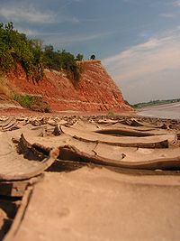
, whereas the clays represent deep-water sediments. The landscape here is flattish, with the only feature of note a rather weak low scarp which meanders across the vale from SW to NE marking the Triassic/Jurassic border. This is superbly illustrated at the ‘Garden Cliff’, Westbury-on-Severn
Westbury-on-Severn
Westbury-on-Severn is a rural village in England that is the centre of the large, rural parish, also called Westbury-on-Severn.-Location:The village is situated on the A48 road and bounded by the River Severn to the south and west.The village has a large parish church which is distinctive as the...
(see picture), where the river Severn has sliced a convenient ‘cut-away’ section of this transition from the red Triassic
Triassic
The Triassic is a geologic period and system that extends from about 250 to 200 Mya . As the first period of the Mesozoic Era, the Triassic follows the Permian and is followed by the Jurassic. Both the start and end of the Triassic are marked by major extinction events...
marl
Marl
Marl or marlstone is a calcium carbonate or lime-rich mud or mudstone which contains variable amounts of clays and aragonite. Marl was originally an old term loosely applied to a variety of materials, most of which occur as loose, earthy deposits consisting chiefly of an intimate mixture of clay...
s, through the thin Penarth Group (formerly 'Rhaetic') strata, to the lias clays and limestones of the lower Jurassic
Jurassic
The Jurassic is a geologic period and system that extends from about Mya to Mya, that is, from the end of the Triassic to the beginning of the Cretaceous. The Jurassic constitutes the middle period of the Mesozoic era, also known as the age of reptiles. The start of the period is marked by...
.
Towards the east side of the Severn Vale the Lias clays are overlain by the sands and limestones of the Middle Lias - well displayed on the slopes of Robinswood Hill, a Jurassic
Jurassic
The Jurassic is a geologic period and system that extends from about Mya to Mya, that is, from the end of the Triassic to the beginning of the Cretaceous. The Jurassic constitutes the middle period of the Mesozoic era, also known as the age of reptiles. The start of the period is marked by...
outlier overlooking the city of Gloucester
Gloucester
Gloucester is a city, district and county town of Gloucestershire in the South West region of England. Gloucester lies close to the Welsh border, and on the River Severn, approximately north-east of Bristol, and south-southwest of Birmingham....
. Further east, forming a rather unstable base to the Cotswold
Cotswolds
The Cotswolds are a range of hills in west-central England, sometimes called the Heart of England, an area across and long. The area has been designated as the Cotswold Area of Outstanding Natural Beauty...
escarpment, are the sands and clays of the Upper Lias.
Superficial deposits are widespread. Floodplain alluvium
Alluvium
Alluvium is loose, unconsolidated soil or sediments, eroded, deposited, and reshaped by water in some form in a non-marine setting. Alluvium is typically made up of a variety of materials, including fine particles of silt and clay and larger particles of sand and gravel...
accompanies the course of the Severn itself as well as tributaries such as the Leadon
River Leadon
The River Leadon is a river in Herefordshire and Gloucestershire, England, a tributary of the River Severn. It rises just south of the village of Acton Beauchamp, and flows south past Bosbury to the town of Ledbury, which takes its name from the river...
, Chelt
River Chelt
The River Chelt is a tributary of England's largest river, the Severn. The Chelt flows through the western edge of the Cotswolds and the town of Cheltenham, before its confluence with the river Severn at Wainlodes Hill...
, Frome
River Frome, Stroud
The River Frome, once also known as the Stroudwater, is a small river in Gloucestershire, England. It is to be distinguished from another River Frome in Gloucestershire, the Bristol Frome....
and Cam. Ancient terraces of former, more elevated floodplains mark the position of the major rivers through various glacial and inter-glacial periods in the last Ice Age
Ice age
An ice age or, more precisely, glacial age, is a generic geological period of long-term reduction in the temperature of the Earth's surface and atmosphere, resulting in the presence or expansion of continental ice sheets, polar ice sheets and alpine glaciers...
. A sheet of mainly Jurassic
Jurassic
The Jurassic is a geologic period and system that extends from about Mya to Mya, that is, from the end of the Triassic to the beginning of the Cretaceous. The Jurassic constitutes the middle period of the Mesozoic era, also known as the age of reptiles. The start of the period is marked by...
limestone fan gravel probably covered most of the vale in the past but has since been eroded away leaving isolated deposits, most notably the Cheltenham Sand, which forms a well-draining light soil in the Cheltenham-Gloucester region.
The Cotswolds
The Middle-Jurassic oolitic limestone series which forms the bulk of the CotswoldsCotswolds
The Cotswolds are a range of hills in west-central England, sometimes called the Heart of England, an area across and long. The area has been designated as the Cotswold Area of Outstanding Natural Beauty...
hills contains the best-known of the county’s rocks on account of its extensive use throughout the area as a building stone. All from churches to humble cottages have been imbued with a mellow, warm character from the golden yellow colour of the stone - to which many ‘honey-pot’ Cotswold towns owe their modern popularity and prosperity. The series is divided into the Inferior and Great Oolite
Oolite
Oolite is a sedimentary rock formed from ooids, spherical grains composed of concentric layers. The name derives from the Hellenic word òoion for egg. Strictly, oolites consist of ooids of diameter 0.25–2 mm; rocks composed of ooids larger than 2 mm are called pisolites...
Groups. The Inferior Oolite, capping the main north-west facing escarpment, comprises up to 100m of mainly oolitic limestones including the Cheltenham freestone - quarried most extensively at Leckhampton
Leckhampton
Leckhampton is a district in south Cheltenham, Gloucestershire, England. The area constitutes a civil parish and is part of the district of Cheltenham.-History:...
and used widely in the distinctive Regency architecture
Regency architecture
The Regency style of architecture refers primarily to buildings built in Britain during the period in the early 19th century when George IV was Prince Regent, and also to later buildings following the same style...
of Cheltenham
Cheltenham
Cheltenham , also known as Cheltenham Spa, is a large spa town and borough in Gloucestershire, on the edge of the Cotswolds in the South-West region of England. It is the home of the flagship race of British steeplechase horse racing, the Gold Cup, the main event of the Cheltenham Festival held...
. The Great Oolite, forming much of the rather barren Cotswold plateau, encompasses a variety of oolitic, shelly, sandy or marly limestone beds, many of which are used for building purposes such as dry-stone walling and roof tiles.
The limestones were predominantly laid down in a shallow warm continental sea, similar to that off the present-day Bahamas, and are rich in fossils of hard-shelled sea creatures such as brachiopods and sea urchins. Clay bands (e.g. the Fuller's Earth Clay at the base of the Great Oolite Series) represent deeper water periods. As the Cotswold dip-slope is followed toward the south-eastern county extremities these clays and mudstones begin to predominate as the Upper Jurassic period Oxford Clay
Oxford Clay
The Oxford Clay Formation is a Jurassic marine sedimentary rock formation underlying much of southeast England, from as far west as Dorset and as far north as Yorkshire. The Oxford Clay is of middle Callovian to lower Oxfordian age and comprises 2 main facies. The lower facies comprises the...
.
Most of the Cotswold rivers flow south-eastwards down the dip-slope, supplying the river Thames, whose headwaters lie at the bottom of the slope on the Upper Jurassic clays. Terrace deposits up to 6m thick of mainly local oolitic limestone gravels have been left by the river Thames in its upper course during glacial and peri-glacial periods. Downcutting and a gradual southerly migration of the river has left a succession of four terraces at varying heights, chiefly north of its present course.
Other areas
- GloucestershireGloucestershireGloucestershire is a county in South West England. The county comprises part of the Cotswold Hills, part of the flat fertile valley of the River Severn, and the entire Forest of Dean....
's oldest rocks occur at Chase End hill in the extreme north-west of the county, where PrecambrianPrecambrianThe Precambrian is the name which describes the large span of time in Earth's history before the current Phanerozoic Eon, and is a Supereon divided into several eons of the geologic time scale...
hornblendeHornblendeHornblende is a complex inosilicate series of minerals .It is not a recognized mineral in its own right, but the name is used as a general or field term, to refer to a dark amphibole....
-gneissGneissGneiss is a common and widely distributed type of rock formed by high-grade regional metamorphic processes from pre-existing formations that were originally either igneous or sedimentary rocks.-Etymology:...
of the Malvern Group forms the southern end of the Malvern HillsMalvern HillsThe Malvern Hills are a range of hills in the English counties of Worcestershire, Herefordshire and a small area of northern Gloucestershire, dominating the surrounding countryside and the towns and villages of the district of Malvern...
before plunging under the TriassicTriassicThe Triassic is a geologic period and system that extends from about 250 to 200 Mya . As the first period of the Mesozoic Era, the Triassic follows the Permian and is followed by the Jurassic. Both the start and end of the Triassic are marked by major extinction events...
cover. - Poorly exposed CambrianCambrianThe Cambrian is the first geological period of the Paleozoic Era, lasting from Mya ; it is succeeded by the Ordovician. Its subdivisions, and indeed its base, are somewhat in flux. The period was established by Adam Sedgwick, who named it after Cambria, the Latin name for Wales, where Britain's...
shales of Tremadoc age form an inlier extending from the TortworthTortworthTortworth is a hamlet, and civil parish, near Thornbury in South Gloucestershire, England. It has a population of 150, and is noted for a huge and ancient chestnut tree, believed to be over 1000 years old. The tree, in St...
area (between GloucesterGloucesterGloucester is a city, district and county town of Gloucestershire in the South West region of England. Gloucester lies close to the Welsh border, and on the River Severn, approximately north-east of Bristol, and south-southwest of Birmingham....
and BristolBristolBristol is a city, unitary authority area and ceremonial county in South West England, with an estimated population of 433,100 for the unitary authority in 2009, and a surrounding Larger Urban Zone with an estimated 1,070,000 residents in 2007...
) northwards to Tites Point on the River SevernRiver SevernThe River Severn is the longest river in Great Britain, at about , but the second longest on the British Isles, behind the River Shannon. It rises at an altitude of on Plynlimon, Ceredigion near Llanidloes, Powys, in the Cambrian Mountains of mid Wales...
. The SilurianSilurianThe Silurian is a geologic period and system that extends from the end of the Ordovician Period, about 443.7 ± 1.5 Mya , to the beginning of the Devonian Period, about 416.0 ± 2.8 Mya . As with other geologic periods, the rock beds that define the period's start and end are well identified, but the...
is also represented in the TortworthTortworthTortworth is a hamlet, and civil parish, near Thornbury in South Gloucestershire, England. It has a population of 150, and is noted for a huge and ancient chestnut tree, believed to be over 1000 years old. The tree, in St...
area, with rocks outcropping along a continuation of the Malvern fault belt south of the Severn. - CarboniferousCarboniferousThe Carboniferous is a geologic period and system that extends from the end of the Devonian Period, about 359.2 ± 2.5 Mya , to the beginning of the Permian Period, about 299.0 ± 0.8 Mya . The name is derived from the Latin word for coal, carbo. Carboniferous means "coal-bearing"...
rocks give rise to the Bristol CoalfieldBristol CoalfieldThe Bristol Coalfield is a geologically complex coalfield in the west of England. Comprising the coal-bearing rocks arranged around the Coalpit Heath Syncline and Kingsdown Anticline, it extends beneath the eastern parts of the city of Bristol and northwards through southern Gloucestershire...
in south-west GloucestershireGloucestershireGloucestershire is a county in South West England. The county comprises part of the Cotswold Hills, part of the flat fertile valley of the River Severn, and the entire Forest of Dean....
.
See also
- Geology of the UK
- GloucestershireGloucestershireGloucestershire is a county in South West England. The county comprises part of the Cotswold Hills, part of the flat fertile valley of the River Severn, and the entire Forest of Dean....
- Forest of DeanForest of DeanThe Forest of Dean is a geographical, historical and cultural region in the western part of the county of Gloucestershire, England. The forest is a roughly triangular plateau bounded by the River Wye to the west and north, the River Severn to the south, and the City of Gloucester to the east.The...
- Forest of Dean CoalfieldForest of Dean CoalfieldThe Forest of Dean Coalfield, lying under the Forest of Dean, in northwest Gloucestershire, is one of the smaller coalfields in the British Isles, although intensive mining during the 19th and 20th centuries has had enormous influence on the landscape, history, culture and economy of the area.For...
- CotswoldsCotswoldsThe Cotswolds are a range of hills in west-central England, sometimes called the Heart of England, an area across and long. The area has been designated as the Cotswold Area of Outstanding Natural Beauty...