

Geology of Cornwall
Encyclopedia
Cornwall
Cornwall is a unitary authority and ceremonial county of England, within the United Kingdom. It is bordered to the north and west by the Celtic Sea, to the south by the English Channel, and to the east by the county of Devon, over the River Tamar. Cornwall has a population of , and covers an area of...
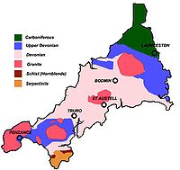
is dominated by its granite backbone, part of the Cornubian batholith
Cornubian batholith
The Cornubian batholith refers to the group of associated granite intrusions which underlie the south-western peninsula of Great Britain. The main exposed masses of the batholith are seen at Dartmoor, Bodmin Moor, St Austell, Carnmenellis, Land's End and the Isles of Scilly. It formed during the...
, formed during the Variscan orogeny
Variscan orogeny
The Variscan orogeny is a geologic mountain-building event caused by Late Paleozoic continental collision between Euramerica and Gondwana to form the supercontinent of Pangaea.-Naming:...
. Around this is an extensive metamorphic aureole (known locally as killas
Killas
Killas is a Cornish mining term for metamorphic rock strata of sedimentary origin which were altered by heat from the intruded granites in Devon and Cornwall, England. The term is used in both Devon and Cornwall.-Origin of killas:...
) formed in the mainly Devonian
Devonian
The Devonian is a geologic period and system of the Paleozoic Era spanning from the end of the Silurian Period, about 416.0 ± 2.8 Mya , to the beginning of the Carboniferous Period, about 359.2 ± 2.5 Mya...
slates that make up most of the rest of the county. There is an area of sandstone and shale of Carboniferous
Carboniferous
The Carboniferous is a geologic period and system that extends from the end of the Devonian Period, about 359.2 ± 2.5 Mya , to the beginning of the Permian Period, about 299.0 ± 0.8 Mya . The name is derived from the Latin word for coal, carbo. Carboniferous means "coal-bearing"...
age in the north east, and the Lizard peninsula is formed of a rare section of uplifted oceanic crust
Oceanic crust
Oceanic crust is the part of Earth's lithosphere that surfaces in the ocean basins. Oceanic crust is primarily composed of mafic rocks, or sima, which is rich in iron and magnesium...
.
Coasts
Great Britain
Great Britain or Britain is an island situated to the northwest of Continental Europe. It is the ninth largest island in the world, and the largest European island, as well as the largest of the British Isles...
, and is therefore exposed to the full force of the prevailing winds that blow in from the Atlantic Ocean
Atlantic Ocean
The Atlantic Ocean is the second-largest of the world's oceanic divisions. With a total area of about , it covers approximately 20% of the Earth's surface and about 26% of its water surface area...
. The coastline is composed mainly of resistant rocks that give rise in many places to impressive cliffs.
The north and south coasts have different characteristics. The north coast is more exposed and therefore has a wilder nature. The prosaically-named High Cliff, between Boscastle
Boscastle
Boscastle is a village and fishing port on the north coast of Cornwall, England, in the civil parish of Forrabury and Minster. It is situated 14 miles south of Bude and 5 miles north-east of Tintagel....
and St Gennys
St Gennys
St Gennys is a coastal civil parish and small settlement in north Cornwall, United Kingdom.The hamlet of St Gennys is situated approximately seven miles southwest of Bude. It is on high ground half-a-mile north of the coastal village of Crackington Haven, the major settlement in the parish...
, is the highest sheer-drop cliff in Cornwall at 735 ft (224 m). However, there are also many extensive stretches of fine golden sand which form the beaches that are so important to the tourist industry, such as those at St Ives
St Ives, Cornwall
St Ives is a seaside town, civil parish and port in Cornwall, England, United Kingdom. The town lies north of Penzance and west of Camborne on the coast of the Celtic Sea. In former times it was commercially dependent on fishing. The decline in fishing, however, caused a shift in commercial...
, Hayle
Hayle
Hayle is a small town, civil parish and cargo port in west Cornwall, United Kingdom. It is situated at the mouth of the Hayle River and is approximately seven miles northeast of Penzance...
, Perranporth
Perranporth
Perranporth is a small seaside resort on the north coast of Cornwall, England, United Kingdom. It is southwest of Newquay and northwest of Truro. Perranporth and its long beach face the Atlantic Ocean....
and Newquay
Newquay
Newquay is a town, civil parish, seaside resort and fishing port in Cornwall, England. It is situated on the North Atlantic coast of Cornwall approximately west of Bodmin and north of Truro....
. The only river estuary of any size on the north coast is that of the Camel
River Camel
The River Camel is a river in Cornwall, UK. It rises on the edge of Bodmin Moor and together with its tributaries drains a considerable part of North Cornwall. The river issues into the Celtic Sea area of the Atlantic Ocean between Stepper Point and Pentire Point having covered a distance of...
, which provides Padstow
Padstow
Padstow is a town, civil parish and fishing port on the north coast of Cornwall, England, United Kingdom. The town is situated on the west bank of the River Camel estuary approximately five miles northwest of Wadebridge, ten miles northwest of Bodmin and ten miles northeast of Newquay...
with a safe harbour.
The south coast, dubbed the "riviera", is somewhat more sheltered and there are several broad estuaries formed by drowned valleys or ria
Ria
A ria is a coastal inlet formed by the partial submergence of an unglaciated river valley. It is a drowned river valley that remains open to the sea. Typically, rias have a dendritic, treelike outline although they can be straight and without significant branches. This pattern is inherited from the...
s that offer safe anchorages to seafarers, such as at Falmouth
Falmouth, Cornwall
Falmouth is a town, civil parish and port on the River Fal on the south coast of Cornwall, England, United Kingdom. It has a total resident population of 21,635.Falmouth is the terminus of the A39, which begins some 200 miles away in Bath, Somerset....
and Fowey
Fowey
Fowey is a small town, civil parish and cargo port at the mouth of the River Fowey in south Cornwall, United Kingdom. According to the 2001 census it had a population of 2,273.-Early history:...
. Beaches on the south coast usually consist of coarser sand and shingle, interspersed with rocky sections of wave-cut platform
Wave-cut platform
A wave-cut platform, or shore platform is the narrow flat area often found at the base of a sea cliff or along the shoreline of a lake, bay, or sea that was created by the action of waves. Wave-cut platforms are often most obvious at low tide when they become visible as huge areas of flat rock...
.
Interior
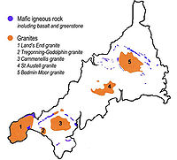
Granite
Granite is a common and widely occurring type of intrusive, felsic, igneous rock. Granite usually has a medium- to coarse-grained texture. Occasionally some individual crystals are larger than the groundmass, in which case the texture is known as porphyritic. A granitic rock with a porphyritic...
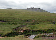
intrusions, such as Bodmin Moor
Bodmin Moor
Bodmin Moor is a granite moorland in northeastern Cornwall, England, United Kingdom. It is in size, and originally dates from the Carboniferous period of geological history....
, which contains the highest land within Cornwall. From east to west, and with approximately descending altitude, these are Bodmin Moor
Bodmin Moor
Bodmin Moor is a granite moorland in northeastern Cornwall, England, United Kingdom. It is in size, and originally dates from the Carboniferous period of geological history....
, the area north of St Austell
St Austell
St Austell is a civil parish and a major town in Cornwall, England, United Kingdom. It is situated on the south coast approximately ten miles south of Bodmin and 30 miles west of the border with Devon at Saltash...
(including St Austell Downs), the area south of Camborne
Camborne
Camborne is a town and civil parish in west Cornwall, England, United Kingdom. It is at the western edge of a conurbation comprising Camborne, Pool and Redruth....
and Redruth
Redruth
Redruth is a town and civil parish traditionally in the Penwith Hundred in Cornwall, United Kingdom. It has a population of 12,352. Redruth lies approximately at the junction of the A393 and A3047 roads, on the route of the old London to Land's End trunk road , and is approximately west of...
, and the Penwith
Penwith
Penwith was a local government district in Cornwall, England, United Kingdom, whose council was based in Penzance. The district covered all of the Penwith peninsula, the toe-like promontory of land at the western end of Cornwall and which included an area of land to the east that fell outside the...
or Land's End
Land's End
Land's End is a headland and small settlement in west Cornwall, England, within the United Kingdom. It is located on the Penwith peninsula approximately eight miles west-southwest of Penzance....
peninsula. These intrusions are the central part of the granite outcrops of south-west Britain, which include Dartmoor
Dartmoor
Dartmoor is an area of moorland in south Devon, England. Protected by National Park status, it covers .The granite upland dates from the Carboniferous period of geological history. The moorland is capped with many exposed granite hilltops known as tors, providing habitats for Dartmoor wildlife. The...
to the east in Devon
Devon
Devon is a large county in southwestern England. The county is sometimes referred to as Devonshire, although the term is rarely used inside the county itself as the county has never been officially "shired", it often indicates a traditional or historical context.The county shares borders with...
and the Isles of Scilly
Isles of Scilly
The Isles of Scilly form an archipelago off the southwestern tip of the Cornish peninsula of Great Britain. The islands have had a unitary authority council since 1890, and are separate from the Cornwall unitary authority, but some services are combined with Cornwall and the islands are still part...
to the west, the latter now being partially submerged.
The uplands are surrounded by more fertile, mainly pastoral
Pasture
Pasture is land used for grazing. Pasture lands in the narrow sense are enclosed tracts of farmland, grazed by domesticated livestock, such as horses, cattle, sheep or swine. The vegetation of tended pasture, forage, consists mainly of grasses, with an interspersion of legumes and other forbs...
farmland. Near the south coast, deep wooded valleys provide sheltered conditions for a flora that likes shade and a moist, mild climate. These areas are mainly of Devonian
Devonian
The Devonian is a geologic period and system of the Paleozoic Era spanning from the end of the Silurian Period, about 416.0 ± 2.8 Mya , to the beginning of the Carboniferous Period, about 359.2 ± 2.5 Mya...
sandstone
Sandstone
Sandstone is a sedimentary rock composed mainly of sand-sized minerals or rock grains.Most sandstone is composed of quartz and/or feldspar because these are the most common minerals in the Earth's crust. Like sand, sandstone may be any colour, but the most common colours are tan, brown, yellow,...
and slate
Slate
Slate is a fine-grained, foliated, homogeneous metamorphic rock derived from an original shale-type sedimentary rock composed of clay or volcanic ash through low-grade regional metamorphism. The result is a foliated rock in which the foliation may not correspond to the original sedimentary layering...
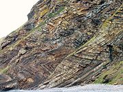
. The north east of Cornwall lies on Carboniferous
Carboniferous
The Carboniferous is a geologic period and system that extends from the end of the Devonian Period, about 359.2 ± 2.5 Mya , to the beginning of the Permian Period, about 299.0 ± 0.8 Mya . The name is derived from the Latin word for coal, carbo. Carboniferous means "coal-bearing"...
rocks known as the Culm Measures
Culm Measures
The Culm Measures are a geological formation of the Carboniferous period that occur in south-west England, principally in Devon and Cornwall. They are so called because of the occasional presence of a soft, sooty coal, which is known in Devon as culm....
. In places these have been subjected to severe folding, as can been seen on the north coast near Crackington Haven
Crackington Haven
Crackington Haven is a coastal village in Cornwall, United Kingdom. It is located in the civil parish of St Gennys at at the head of a cove on the Atlantic coast. The village is seven miles south-southwest of Bude and four miles north-northeast of Boscastle.Middle Crackington and Higher...
, spectacularly at the Whaleback Pericline on the beach just south of Bude
Bude
Bude is a small seaside resort town in North Cornwall, England, at the mouth of the River Neet . It lies just south of Flexbury, north of Widemouth Bay and west of Stratton and is located along the A3073 road off the A39. Bude is twinned with Ergué-Gabéric in Brittany, France...
and at several other locations.
Granite
Metamorphism
Metamorphism is the solid-state recrystallization of pre-existing rocks due to changes in physical and chemical conditions, primarily heat, pressure, and the introduction of chemically active fluids. Mineralogical, chemical and crystallographic changes can occur during this process...
and mineralisation
Mineralization (geology)
In geology, mineralization is the hydrothermal deposition of economically important metals in the formation of ore bodies or "lodes".The first scientific studies of this process took place in Cornwall, United Kingdom by J.W.Henwood FRS and later by R.W...
, and this led to Cornwall being one of the most important mining areas in Europe until the early 20th century. It is thought that tin ore (cassiterite
Cassiterite
Cassiterite is a tin oxide mineral, SnO2. It is generally opaque, but it is translucent in thin crystals. Its luster and multiple crystal faces produce a desirable gem...
) was exploited in Cornwall as early as the Bronze Age
Bronze Age
The Bronze Age is a period characterized by the use of copper and its alloy bronze as the chief hard materials in the manufacture of some implements and weapons. Chronologically, it stands between the Stone Age and Iron Age...
. Over the years, many other metals such as copper
Copper
Copper is a chemical element with the symbol Cu and atomic number 29. It is a ductile metal with very high thermal and electrical conductivity. Pure copper is soft and malleable; an exposed surface has a reddish-orange tarnish...
, lead
Lead
Lead is a main-group element in the carbon group with the symbol Pb and atomic number 82. Lead is a soft, malleable poor metal. It is also counted as one of the heavy metals. Metallic lead has a bluish-white color after being freshly cut, but it soon tarnishes to a dull grayish color when exposed...
, zinc
Zinc
Zinc , or spelter , is a metallic chemical element; it has the symbol Zn and atomic number 30. It is the first element in group 12 of the periodic table. Zinc is, in some respects, chemically similar to magnesium, because its ion is of similar size and its only common oxidation state is +2...
and silver
Silver
Silver is a metallic chemical element with the chemical symbol Ag and atomic number 47. A soft, white, lustrous transition metal, it has the highest electrical conductivity of any element and the highest thermal conductivity of any metal...
have all been mined in Cornwall
Mining in Cornwall
Mining in Cornwall and Devon began in the early Bronze Age approximately 2,150 BC and ended with the South Crofty tin mine in Cornwall closing in 1998...
. Alteration of the granite also gave rise to extensive deposits of china clay (kaolinite
Kaolinite
Kaolinite is a clay mineral, part of the group of industrial minerals, with the chemical composition Al2Si2O54. It is a layered silicate mineral, with one tetrahedral sheet linked through oxygen atoms to one octahedral sheet of alumina octahedra...
), especially in the area to the north of St Austell
St Austell
St Austell is a civil parish and a major town in Cornwall, England, United Kingdom. It is situated on the south coast approximately ten miles south of Bodmin and 30 miles west of the border with Devon at Saltash...
, and this remains one of Cornwall's most important industries.
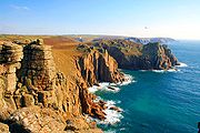
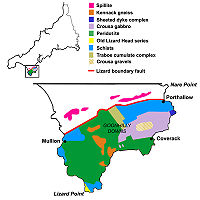
The Lizard peninsula
Great Britain
Great Britain or Britain is an island situated to the northwest of Continental Europe. It is the ninth largest island in the world, and the largest European island, as well as the largest of the British Isles...
's most complete example of an ophiolite. Much of the peninsula consists of the dark green and red rock, serpentinite
Serpentinite
Serpentinite is a rock composed of one or more serpentine group minerals. Minerals in this group are formed by serpentinization, a hydration and metamorphic transformation of ultramafic rock from the Earth's mantle...
, which forms cliffs as at Kynance Cove
Kynance Cove
Kynance Cove is a cove in southwest Cornwall, United Kingdom. It is situated on the Lizard peninsula approximately two miles north of Lizard Point...
, and can be carved and polished to create ornaments. This ultramafic rock forms a very infertile soil which covers the flat and marshy heaths of the Goonhilly Downs
Goonhilly Downs
Goonhilly Downs is a Site of Special Scientific Interest that forms a raised plateau in the central western area of the Lizard Peninsula in Cornwall, England, UK. Situated just south of Helston and the Naval Air Station at Culdrose, it is famous for its Goonhilly Satellite Earth Station, the...
.
Mining and quarrying
Extraction of tin began in Cornwall in prehistoric times and continued until the late 20th century. Historically extensive tinTin
Tin is a chemical element with the symbol Sn and atomic number 50. It is a main group metal in group 14 of the periodic table. Tin shows chemical similarity to both neighboring group 14 elements, germanium and lead and has two possible oxidation states, +2 and the slightly more stable +4...
and copper
Copper
Copper is a chemical element with the symbol Cu and atomic number 29. It is a ductile metal with very high thermal and electrical conductivity. Pure copper is soft and malleable; an exposed surface has a reddish-orange tarnish...
mining has occurred in Devon and Cornwall, as well as arsenic
Arsenic
Arsenic is a chemical element with the symbol As, atomic number 33 and relative atomic mass 74.92. Arsenic occurs in many minerals, usually in conjunction with sulfur and metals, and also as a pure elemental crystal. It was first documented by Albertus Magnus in 1250.Arsenic is a metalloid...
, silver, zinc and a few other metals. Granite, slate and aggregate
Construction Aggregate
Construction aggregate, or simply "aggregate", is a broad category of coarse particulate material used in construction, including sand, gravel, crushed stone, slag, recycled concrete and geosynthetic aggregates. Aggregates are the most mined material in the world...
are still quarried and china-clay
Kaolinite
Kaolinite is a clay mineral, part of the group of industrial minerals, with the chemical composition Al2Si2O54. It is a layered silicate mineral, with one tetrahedral sheet linked through oxygen atoms to one octahedral sheet of alumina octahedra...
extraction continues on a large scale.
There are ample supplies of granite worth the cost of shipping out of the county and much Cornish granite has been used in distant places. It is one of the most appropriate materials for memorials and examples are found in most parts of Cornwall. there are no active metalliferous mines remaining. However, tin deposits still exist in Cornwall
Cornwall
Cornwall is a unitary authority and ceremonial county of England, within the United Kingdom. It is bordered to the north and west by the Celtic Sea, to the south by the English Channel, and to the east by the county of Devon, over the River Tamar. Cornwall has a population of , and covers an area of...
, and there is talk of reopening South Crofty
South Crofty
South Crofty is a metalliferous Tin and Copper mine located in the village of Pool, Cornwall, England UK. An ancient mine, it has seen production for over 400 years, and extends almost two and a half miles across and down and has mined over 40 lodes. Evidence of mining activity in South Crofty has...
tin mine.
Geological studies were made worthwhile due to the economic importance of mines and quarries: about forty distinct minerals have been identified from type localities
Type locality (geology)
Type locality , also called type area or type locale, is the where a particular rock type, stratigraphic unit, fossil or mineral species is first identified....
in Cornwall, e. g. endellionite
Bournonite
Bournonite is a sulfosalt mineral species, a sulfantimonite of lead and copper with the formula PbCuSbS3.It was first mentioned by Philip Rashleigh in 1797 as an ore of antimony and was more completely described in 1804 by French crystallographer and mineralogist Jacques Louis de Bournon , after...
from St Endellion
St Endellion
St Endellion is a civil parish and village in north Cornwall, England, United Kingdom. The village and parish church are situated four miles north of Wadebridge....
.
See also
- Geography of CornwallGeography of CornwallThe geography of Cornwall describes the extreme southwestern peninsula of Great Britain west of the River Tamar. The population of Cornwall is greater in the less extensive west of the county than the east due to Bodmin Moor's location; however the larger part of the population live in rural areas...
- List of Cornish geologists and explorers
- Royal Geological Society of CornwallRoyal Geological Society of CornwallThe Royal Geological Society of Cornwall is a geological society based in Cornwall in the United Kingdom. It was founded in 1814 to promote the study of the geology of Cornwall, and is the second oldest geological society in the world....